The Miao Ethnic Minority is the 4Th Largest Ethnic Minority Group in China.
Miao Ethnic Culture in China :
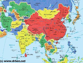
Asia Report - Map of Asia Entire . All Countries, Borders & Capitals
Full Geographical Overview Map of Asia Entire with Zoom & Scroll Functions, Relief Feautures, Oceans, Main Rivers and Capital Cities.
This Map of Asia includes all Asian Countries with Names and Borders, Disputed Border Regions in Asia, Capital Cities of all Asian Countries and Main Rivers and Mountain Ranges.
The Miao Ethnic Minority is ...
History of the Miao Ethnic Group in China :
The ancestors of the Miao minority in China immigrated into
Language :
The ...
Festivals of the Miao Ethnic Group - XXX and others :
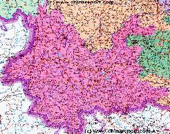
A Full and complete Map of China (PRC) identifying all Language Areas big and small in all Provinces and Autonomous Regions of China.
Map includes Turkic Languages (Uygur, Kazakh, Kirghiz, Salar & Uzbek), Mongolian Language and Sub-Divisions (Mongol, Tu, Daur and Dongxian), Tungusic Peoples (Oroqen, Evenki and Xibe) and Languages, Korean, Tajik (Tadzhik), Mon-Khmer (Kawa + Puman (or Pulang)), Hui, Uygur (Uighur), Tibeto-Bhurman Languages, Tai and Miao, Yao and She' Language Area's and Borders. Main Area's and sub-divisions of Han Languages (Northern Mandarin, Eastern Mandarin, South-Western Mandarin and Cantonese) further included. This color-coded ethno-linguistic Map (of 1967 AD) identifies at a glance most ethnic minority regions in China
Map China Ethno-Linguistic / Language Distribution China
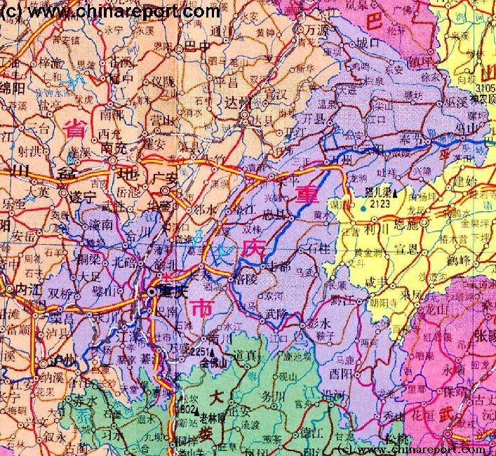
ChongqingCity Province Map 1A - Geographic Map
A Geographic overview Map of Chongqing City Province entire delineating provincial borders and parts of neighboring Shaanxi Province in the North, Hubei Province in the North and East, Hunan Province in the South-East, Guizhou Province in the South and Sichuan Province in the West. Includes Cities and Towns (shown by size), Main Monuments & Landmarks of Chongqing City Province such as the Three Gorges o/t Yangtze River, The 3 Gorges Dam, the lesser Three Gorges of the Daning River and the location of Miao and Tujia Ethnic Minority communities in Chongqing City Province. Other map features are the locations of Main Mountains (with Height), major highways, provincial railroads and main railroad-stations, and main waterways & rivers.
This Map further provides links to on site photos and information on the Cities and Main Monuments Other sites will be included in the Future.
Yunnan Province Geographic Map 1A
A Schematic overview Map of YunnanProvince entire and large parts of neighboring Regions of TibetAutonomousRegion, SichuanProvince,ChongqingCityProvince, GuizhouProvince, aswellasthenationsofLaos and Myanmar(Burma).
This Map Includes Cities and Towns (shown by size), the location of ethnic minority communities of various size, Main Monuments & landmarks of YunnanProvince, major highways and roads, provincial railroads, a variety of border passes intoBurmaandLaos, main mountains with height plus main waterways, rivers and lakes of this large region. Please browse the map and follow the links to more information.
Sichuan Province Geographic Map 1A
A Geographic overview Map of Sichuan Province entire, and parts of bordering regions of Qinghai Province, Gansu Province, Shaanxi Province, Chongqing City Province, Guizhou Province, Yunnan Province and Tibet AR. The Map clearly delineates Sichuan Province provincial borders. This Map Includes Cities and Towns (shown by size), Main Monuments & landmarks of Sichuan Province, Main Mountains (with Height), major highways, provincial railroads and main railroad-stations and main waterways & rivers. This Map further provides links to on site photos and information on the City and Area of Chengdu, nearby Cities & Villages. Other scenic or historical sites will be included in the Future.