Hotels in Kyŏngsŏng City
Ethnic Minorities in Kyŏngsŏng
Learn More about the Ethnic Nationalities in Kyŏngsŏng
Kyŏngsŏng & City Today :
History of Kyŏngsŏng :
Kyŏngsŏng Climate & Weather :
Kyŏngsŏng Basic Knowledge :
To The China Report Main Menu
This page was last updated on: August 30, 2013
The Kyŏngsŏng Report
Introduction to Kyŏngsŏng (--)
Kyŏngsŏng Landmarks & Monuments
Kyŏngsŏng City & Area Maps
Location : (....)
Elevation : no information available.
Surface Area:
Urban - No Data.
County of Kyŏngsŏng - no information available.
Go to www.drben.net webring
To Main Menu of All Websites at DrBen.Net
KoreasReport.com at
Tadjik
Camel Driver on the Silk Road, China
Tadjik Camel Driver on the Silk Road, China Photographic Print
Su, Keren
Found it at ChinaReport.com!
Alphabetically ordered list of Monuments, Landmarks and other sites of interest in and around Kyŏngsŏng
A Full listing of Kyŏngsŏng City Landmarks, Monuments, Hotspots and other sites of importance in alphabetical order. Search through the list to find your Full Report and Photo-Virtual Tour of each monument or landmark within Kyŏngsŏng in Kyŏngsŏng County of North Hamgyong Province in the Democratic Peoples Republic of Korea (North Korea).
Public Transport in Kyŏngsŏng
Main Railroad Station of Kyŏngsŏng - Photos and Introduction
The Main Station of Kyŏngsŏng is located central within the Central City District.
Book Hostels Online Now
Complete Listing of available Hotels in Kyŏngsŏng, Kyŏngsŏng County, North Hamgyong Province, Democratic Peoples Republic of Korea (North Korea).
Kyŏngsŏng has a -- Railroad Station, no information available.
No Information available at this Time.
Find out the Details in the History of Kyŏngsŏng
Be a 7Search.com Advertiser!
No Information available at this Time.
Be a 7Search.com Advertiser!
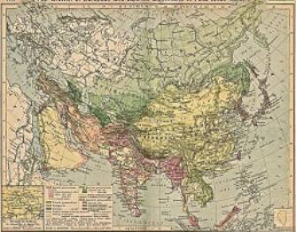
China Report - Colonialism - Growth of Colonies & Japan after 1801 AD
A Map drawing of the Eurasian continent , parts of North-East Africa and the Middle East in the 19Th Century between 1801 AD and 1900 AD. Focal points are the expansion of western colonial posessions of Portugal, Britain and France, as well as  Russia moving from West to East. Labeled seperately is the later Rise of the Empire of Japan in the East.
Included in this Map are the main cities across the continent with their brief histories and events during the 19Th Century. Marked in Colors for clarity are the various colonial and imperialist Nations. As relating to China; special attention is payed to so called Treaty Ports. The First Treaty Ports were forced open by Britain in the year 1841 AD, but counted over 80 in total by the end of the 19Th Century. The most important Treaty Ports in China are marked and described with a short history where the map allows.
Map China and Far East Colonies after 1801 AD
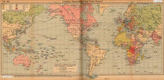
Colonialism - 1912 World Map of Colonial Possessions & Trade Routes.
A Map drawing of the World depicting the Colonial Possessions as they were distributed in 1912 AD. Superimposed and marked in colors are subsequent changes in Influences Spheres, colonies and possessions due to World War I ( 1914 AD - 1918 AD).
Included in this Map are the main cities across the continents with their brief histories and events during the late 19Th Century and early 20Th century, where relevant. Marked in Colors for clarity are the various colonial and imperialist Nations. As relating to China; special attention is payed to so called Treaty Ports. The First Treaty Ports were forced open by Britain in the year 1841 AD, but counted over 80 in total by the end of the 19Th Century.
Click through for Full Version !!
Check out MEGA - 100% Secure file-sharing by Kim.com !!
This page was last updated on: August 30, 2013
My Great Web page
Click Map to go to FUL Version !!
Kyŏngwŏn
Myongan, Myongan County, North Hamgyong Province, North Korea (D.P.R.K.).
Namyang, Onsong County, North Hamgyong Province, North Korea (D.P.R.K.).
No Information available at this Time.
The Korea Report
The Korea Report is part of the overall website www.AsiaReport.com & www.drben.net
Learn about what is new on this Site from below window.
Hi! from Doc Ben and Proud Staff
Click to Go to Large Scale Map 1A
Find DrBen and AsiaReport on Facebook with the latest from www.drben.net.
DrBen Nijhoff | Maak je eigen badge
Musan, Musan County, North Hamgyong Province, North Korea (D.P.R.K.).
Onsong, Onsong County, North Hamgyong Province, North Korea (D.P.R.K.).
Chongjin City, North Hamgyong Province, North Korea (D.P.R.K.).
Hoeryong City, North Hamgyong Province, North Korea (D.P.R.K.).
Puryong, Puryong County, North Hamgyong Province, North Korea (D.P.R.K.).
Orang, Orang County, North Hamgyong Province, North Korea (D.P.R.K.).
Kilju, Kilju County, North Hamgyong Province, North Korea (D.P.R.K.).
Kimch'aek City (formerly Sŏngjin), North Hamgyong Province, North Korea (D.P.R.K.).
Myongchon, Myongchon County, North Hamgyong Province, North Korea (D.P.R.K.).
Kyongsong, Kyongsong County, North Hamgyong Province, North Korea (D.P.R.K.).
Korea Embassies
Korea Online Sources
Asia Photo Galleries
DrBen.Net Home
China Provinces /Home
DrBen.Net Store
China
AsiaReport.com Home
Asia
Korea Home
Korea
Korea Maps
Koreas Introduction
North Korea
Pyongyang
Rason
South Pyongan
North Pyongan
Chagang
South Hwanghae
North Hwanghae
Kangwon
South Hamgyong
North Hamgyong
Ryanggang
Kyŏngwŏn (Saebyol), Kyŏngwŏn County, North Hamgyong Province, North Korea (D.P.R.K.).
Rason
Sonbong District, Rason City, North Hamgyong Province, North Korea (D.P.R.K.).