According to sparse information made available by the local Hainan Provincial Government and organs the population of Wuzhishan County-Level City is a total of some 110 thousand. In what is regarded as still very much a rural and remote area some 60% of this population is said to be of Li Ethnic Origins. There is no information on the other ethnic groups present.
For more information, please refer to ethnic minorities in Hainan Province.
Ethnic Minorities in Wuzhishan & County
Wuzhishan Today :
History of Wuzhishan:
Wuzhishan Climate & Weather :
Wuzhishan Basic Knowledge :
This page was last updated on: June 1, 2017
The Wuzhishan Report
Introduction to Wuzhishan County (--)
Wuzhishan Landmarks & Monuments
Wuzhishan & County Maps
Location : 20°02′34 North, 110°20′30 East
Elevation : The Wuzhi Shan with a height of 1840 meters (6040 ft) is the highest mountain on Hainan Island.
Surface Area: 1129 Square Kilometers.
The China Report
The Wuzhishan Report is part of the overall website www.ChinaReport.com & www.drben.net
Learn about what is new on this Site from below window.
ChinaReport.comat
LANDMARKS OF TONGZA:
Hainan Ethnic Museum
- Ethnic Nationality Cultural Museum (Minzu Bowuguan)(Li and Miao Customs Village)
- Qiongzhou University (Not a tourist landmark)
LANDMARKS OF WUZHISHAN COUNTY:
- Atuoling Provincial Forest Park
- Taiping-Shan Waterfall (some 5km from Tongza).
- Wuzhi Shan (Five Finger Mountain ) Natural Reserve (Technically not In Wuzhishan County).
- Wuzhishan Grand Canyon.
- Yingge Ling Mountain Forest Reserve.
There is no information available on the landmarks and Monuments of Wuzhishan County at this Time.
Public Transport in Wuzhishan
There is no Railway Station available in Wuzhishan. The nearest train station is found at Ledong Town of Ledong Li Autonomous County to the west / south-west. Ledong has a station of the Hainan Western-Ring High-Speed Railway which since 2017 connects to destinations around the Island Coast.
Wuzhishan County-Level City has no airport and no train station. This central part of the Island and its central town of Tongza can only be reached by road. Main road leading to Tongza Town is G224 National Road. This is also the main road in all of Wuzhishan County-Level City. Secondary roads leading to other counties are S313 and S314 Provincial Roads. All other roads are minor county roads of the X+number type.
No information available.
In 1949 during the establishment of the New China (Xinhua) in the shape of the Peoples Republic of China, the Minorities of Hainan Island, having played a crucial role in the insurrection against Japanese Occupation of the Island as well as in the invasion and Communist take-over of Hainan Island found themselves rewarded with Ethnic Autonomous Status of the Island. The first Communist Base Area of Hainan Island was set up in the town of Tongza in Wuzhishan County under the leadership of Li Ethnic Rebel and Hero Wang Guo Xing.
In 1955 Tongza was chosen as the logical location for the first local Government of Hainan Island and Tongza became the first Capital of Hainan Island during the Peoples Republic. This status was lost in 1988 when Haikou became the Capital of the Island.
The name of the central town of Tongza was changed to Wuzhishan in the year 2001.
Main Town is Tongza also known as Tonshi or Wuzhishan City. Some 8.8 kilometers east by south-east lies the town of Nansheng (Nancheng) which is named after the local Nancheng River which is also a part of Tongza Town. 16.6 kilometers to the north-west lies Panyang Town (Panyang Zhen). No other major towns exist but various villages lie surrounding the central town of Tongza.
The town of Tongza has a school, the Qiongzhong University.
There is no information available on life in current Wuzhishan on Hainan island.
Our pages on Wuzhishan Town and County do not contain Hotel Reviews. For an overview of Hotels & Resorts to book in Wuzhishan County, there are two available options.
For a Complete Overview of available Hotels & Resorts on all of Hainan Island, please click through and refer to "Hotel Booking on Hainan Island".
For an overview of Hotels specifically in Wuzhishan County, please refer to below button for information on the nearest available Hotels. Basic information by Hotel, includes map of the area and overview of Hotel locations within that area.
Qiongzhong Li and Miao Autonomous County, makes up the eastern border. Distance from Tongza Town to the Mountain proper is some 23.7 kilometers. The northernmost parts of Wuzhishan County-Level City are made up by the difficult to reach Yinggeling National Level Forest Nature Reserve which probably represents the most pristine natural environment to be found on the island today. The distance from Tongza Town to Yinggeling Mountain is some 29.7 kilometers and to the north of this protected natural forest lies the territory of Baishi Li Autonomous County whereas to the north-east one finds ones self within Qionzhong Li and Miao Autonomous County.
The central town of what used to be the rural county by the same name was known as Tongza or also Tongshi until the year 2001. Tongza, in Li Language translates to something alike Rice grown on top of a mountain, which is a natural name for a town and community as it is. Thus, for historic and cultural reasons the town is still often referred to by locals as Tongza (通什) rather than Wuzhishan. This central town is situated due north-west of Baoting, center of Baoting Li Autonomous County along G2224 National Road and sits at the point of confluence of no less than 3 local rivers. The largest of these rivers are the Tongsi River (Tongsi He) which flows the west of Tongza Town, and the Nancheng River which flows from the towns center in a generally eastward direction. In town this river is dammed in various places but outside of town it retakes its continuity. The third river is the Shanghao River (Shanghao He) which flows from the south-west of town northward to join with the Tongsi River as a tributary.
To most Foreigners Wuzhishan and its central town are that obscure that most randomly available travel guides give virtually no information about this administrative territory, the town of Tongza or any of the surrounding villages.
What is generally known about today′s Wuzhishan is that it is an off the beaten path travel destination, especially for foreigners. The area is mostly renowned for its last remaining vestiges of tropical forest on Hainan Island extending across the Limuling Mountain Range which forms the backbone of Hainan Island. The unique tropical forests of these mountains are endowed with some 1400 species of tropical wood and numerous species of plants, birds, insects and mammals not all of which may yet have been identified and other such as the Hainan Gibbon which are extinct in the other parts of island. The main tourist destination for tropical forest adventures is currently the Wuzhishan Mountain Nature Reserve, but the greater gem of Wuzhishan County is the 500 square kilometer large Yinggeling Primeval Forest Nature Reserve.
In fact, the the Yinggeling Forest had reportedly never been properly studied before a first team of scientists reviewed its biodiversity as part of a pilot
Juding
Tongza and Wuzhishan County-Level City have no airport. The nearest Airport is Sanya Phoenix International Airport which can be reached by Express Bus which reaches Sanya Poenix Airport in some 2.5 hours traveling time.
Airport : There is no airport in Wuzhishan County. Nor any military airfield.
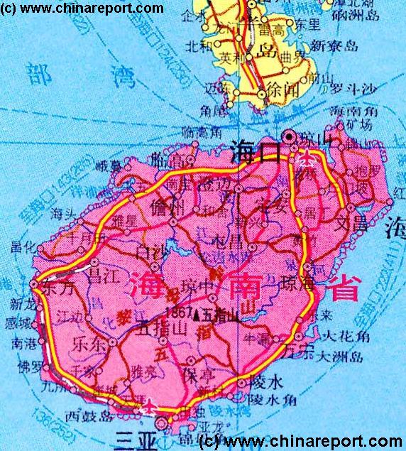
There are no Maps available on Wuzhishan County at this Time.
Wuzhishan County is named after the Wuzhi Shan (五指山 ; Wuzhi Mountain a.ka. "Five Finger Mountain", which with its 1840 meters (6040 ft) in height is the highest mountain on Hainan Island and in Hainan Province). As one may expect from a volcanic island, the Wuzhi Mountain is situated very near the center of Hainan Island. The County-Level City of Wuzhishan is situated adjacent the high mountain, which however is not a part of its administrative area.
Wuzhishan County-Level City is not a city urban zone but a large mountainous land area with the administrative status of a low-tier city. This large area is situated just to the south-west of the center of the island.
Clock-wise around Wuzhishan County is bordered to the north and north-west by Baisha Li Autonomous County, to the east by Qiongzhong Li and Miao
Geographically speaking, Wuzhishan County-Level City is more difficult to delineate. All of the territories of the County-Level City lie well above sea level. The main border markers seem to be first and foremost the Wuzhi Mountain itself, which as a part of neighboring
program for eco conservation and sustainable living in Southern China (PRC). As late as the year 2005 animal species previously unknown to man were being identified inside this vast tropical mountain forest. Among the many new species identified at the time one species was named the Yinggeling Tree Frog (Rhacophorus Yinggelingensis) after the unique forest habitat which it inhabits. In 2006 an expedition identified various species of Begonia and new orchid species along with some 79 other previously unknown life forms. In 2009 scientists identified a new tropical insect now named Dolichothyreus Stigmatus and a new tree species named Trigonobalanus Verticalata.
Since the year 2006 local park wardens and biologists work hand in hand with local Li minority people, as it is understood that the interest of the local people must be raised in order to protect the forest from infringements such as illegal logging of rare tropical woods, and poaching of endangered animals and species. Local villages are given a stake in the protection of the forest in return for Government support for ecology friendly tourism projects which help to bring financial resources to the otherwise disconnected villages of the innermost parts of Hainan Island. Ecotourism may also be a road to help preserve some of the endangered Li Ethnic Cultural traits by creating a limited market for their various handicrafts and local products.
Interestingly, although a new road is being built north of Tongza Town, partially
intended to connect to Yinggeling Forest Nature Reserve, the plan agreed upon by local authorities, the park and the Li communities is to allow for no more than 2000 tourists to visit the park per year. Being allowed a visit might thus be held as great honor and privilege. Presumably, the target audience will be an informed public especially looking for the chance to explore the forest and photograph species, although none of this has yet been revealed.
Predominantly due to its inhospitable terrain and up until recently deadly tropical diseases, the Yinggeling and Wuzhishan Mountains area is mostly uninhabited and thus can boast the largest surface area covered by original tropical vegetation of all the administrative area′s on Hainan Island. In addition to the attraction of the tropical forest the remoteness and difficult terrain have also allowed for the preservation of local villages, their unique ethnic architecture and essential parts of the original Li Nationality culture of Hainan Island. It is said that the most original and least changed Li ethnic villages on the island are to be found within Wuzhishan County-Level City with some of the Li Villages having a history going back some 300 years.
Although considered remote and not A-listed, day trippers do come to Wuzhishan County. Travelers can only reach the area and town by road. Organized tour packages are offered by local travel agencies taking some 2.5 hours to travel up G224 National Road from Sanya to take visitors on a tour of the local Li Ethnic Cultural Museum Village of some 40 hectares and/or boost their tour group further up the mountain for a tropical forest experience which may include wild water rafting, but in most cases stays limited to visit to the local Taiping-Shan waterfall and other scenic locations of Taiping Mountain situated at but some 5 kilometers from Tongza Town. More adventurous tourists can travel further north to the Wuzhishan Grand Canyon of the Maoyang River (Maoyang He), which apart for being a renowned scenic area offers opportunities for white water rafting and other water filled adventures.
Quite a different group of travelers passing through Tongza and Wuzhishan are the avid bicyclist which come to Hainan Island to enjoy the sunny weather, the challenge or leisure of bicycling and of course the clean air. Tongza, due to its mountain challenges is a favorite stop-over point on many a bicycling route including the more difficult terrain of the inland of the island.
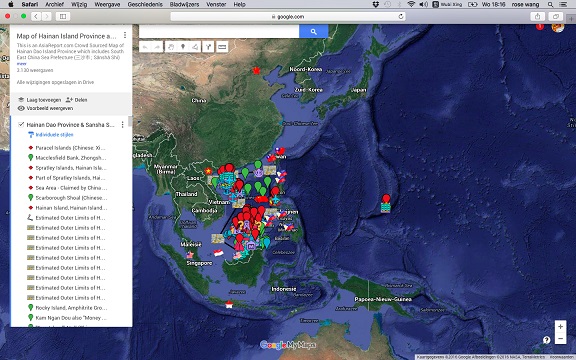
Asia Report - Map of Hainan Island Province including South China Sea Prefecture
This Google supported Satellite Map provides a clear overview of Hainan Island Province of the Peoples Republic of China, including its South China Sea Prefecture. Map of the South China Sea further includes parts of Taiwan and coastline, Gulf of Tonkin, coastline of Vietnam, Brunei, Borneo (Malaysia), and western Philippines.
Marked on the map for orientation are the names of major National Capitals, locally relevant cities, several towns and villages, names of oceans, islands in the South China Sea, as well as locations of interest such as naval bases, artificial islands, airfields, tourism locations, etc.
Browse the map and follow the links to more information, maps and photos of each location.