Ethnic Minorities in Changsha & Prefecture

Changsha, as ..
Learn More about the Ethnic Nationalities in Changsha
Changsha & City Today :
History of Changsha:
Changsha Climate & Weather :
Changsha Basic Knowledge :
To The China Report Main Menu
This page was last updated on: August 2, 2013
The Changsha Report
45007
Introduction to Changsha (长沙)
Changsha Landmarks & Monuments
Changsha City & Area Maps
Location : (....)
Elevation : 3494 Feet/ 1065 Meters.
Surface Area:
Urban - xxx
City Prefecture of Changsha - ?? sq Kilometers (?? sq miles)
Population: The Total Urban Population of Changsha City is aroundxxd with an additional xxx living in the rural area's of the City Prefecture.
Go to www.drben.net webring
To Main Menu of All Websites at DrBen.Net
ChinaReport.com at
Tadjik
Camel Driver on the Silk Road, China
Tadjik Camel Driver on the Silk Road, China Photographic Print
Su, Keren
Found it at ChinaReport.com!
Alphabetically ordered list of Monuments, Landmarks and other sites of interest in and Around Changsha
Full Documentary DVD set - Revealing China by Discovery Channel !!
Discovery Atlas - China revealed.
2006 Edition, full DVD disc set !!  Buy it Now.
A Full listing of Changsha City Landmarks, Monuments, Hotspots and other sites of importance in alphabetical order. Search through the list to find your Full Report and Photo-Virtual Tour of each monument or landmark within the City, or Region of Changsha in Hunan of China (PRC).
Public Transport in Changsha
Main Railroad Station of Guyuan - Photos and Introduction
The Main and only Railway Station of Changsha City, located due East of the City Center of Changsha and some distance away along the highway to the East. As the arrival point for many, the Main Station is home to a number of essential Services. As is the New Airport !
Book Hostels Online Now
Complete Listing of available Hotels in Changsha, Hunan Province, China (PRC).
Click to Go to Large Scale Map 1A


CD Universe - Buy Video Games for Nintendo Wii, PlayStation 3, XBox 360, PlayStation 2, XBox, Sony PSP, GameCube, PC Games at Every Day Low Prices
Night Market, Id Kah Square, Kashgar (Kashi), Chinese Turkestan, China
Night Market, Id Kah Square, Kashgar (Kashi), Chinese Turkestan, China Photographic Print
Poole, David
Kirkiz Women on the Pamir Plateau with Traditional Scythes, Kashgar, China
Kirkiz Women on the Pamir Plateau with Traditional Scythes, Kashgar, China Photographic Print
Su, Keren
Documentary Gift Box - Full History of the Shanxi Merchants & The First Draft Bank of China !
DVD - Shanxi BusinessMen, full 4 DVD disc set revealing the story of the Merchants Block from Shanxi !!  Buy it Now.
Changsha has a Railroad Station.
History :
Han Dynasty
Tang Dynasty
Ming Dynasty
Ching Dynasty
CHANGSHA, Aug 21, 2012 (Xinhua via COMTEX) --

Chinese archaeologists said a 2,100-year-old tomb famous as the final resting place of a perfectly preserved female corpse is being threatened by residents' rampant soil looting as local residents believed that good "feng shui" there produced "holy soil".

Mawangdui, a small hill in the eastern suburbs of Changsha, capital of central Hunan Province, is home to the grand tombs of the Marquis of Dai during the Han Dynasty (202 BC - 220 AD), as well as his wife and son.

In recent years, local residents have taken soil from the site to use for planting flowers or making marinated eggs, as they believe the site's good "feng shui" has produced a superior soil, said Li Jianming, curator of the Hunan Provincial Museum.

"Some citizens say the tomb's good feng shui creates better soil," Li said.

Most artifacts unearthed from the tombs are currently exhibited in the museum, but Li said the many holes left by those taking away soil have posed a threat to the tomb's external structures.

The Mawangdui site grabbed international attention when researchers found a female corpse that showed no signs of decay when her coffin was opened in the 1970s. An autopsy determined that the woman, identified as Lady Dai, died of a heart attack in her 50s.

Thousands of well-preserved artifacts uncovered from the tombs, including a very thin T-shaped silk painting, have also contributed to the fame of the site.

Hunan's archaeological authorities said Mawangdui is co-managed by the provincial museum and a nursing home, but it has no security guards, except two elderly ticket sellers and some volunteers sent by the hospital.

"We receive no funding or government subsidies, and our efforts can not stop the diggers' constant visits," said a hospital employee.

The security situation at Mawangdui is fairly common among ancient ruins in China's countryside, as experts said many such sites are hardly protected, making them easy targets for theft and damage.

Last year, part of the country's oldest fortification was destroyed by workers involved in a power plant project in a mountainous region of Henan Province. Local authorities said they lacked security personnel and did not learn about the damage until several months later, after construction work had progressed.

No Information available at this Time.
Find out the Details in the History of Changsha
Changsha
Changsha Home
Hunan Sources
Hunan Province
Hunan Province Home
China Offline Sources
AsiaReport.com Home
China Report Home
China Online Sources
China Online Store
China Maps
China
China Photo Galleries
China Report Club
Hunan Economy
Hunan Monuments
Hunan Maps
Hunan Minorities
Changsha Districts
Furong District
Suburban & Rural
Changsha Xian
Kaifu District
Hunan Transport
Hunan History
Be a 7Search.com Advertiser!
No Information available at this Time.
Tianqin District
Yuelu District
Yuhua District
Liuyang Shi
Ningxiang Xian
Wancheng Xian
Be a 7Search.com Advertiser!
Find DrBen and ChinaReport on Facebook with the latest from www.drben.net.
DrBen Nijhoff | Maak je eigen badge
China Report - Colonialism - Growth of Colonies & Japan after 1801 AD
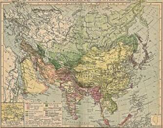
A Map drawing of the Eurasian continent , parts of North-East Africa and the Middle East in the 19Th Century between 1801 AD and 1900 AD. Focal points are the expansion of western colonial posessions of Portugal, Britain and France, as well as  Russia moving from West to East. Labeled seperately is the later Rise of the Empire of Japan in the East.
Included in this Map are the main cities across the continent with their brief histories and events during the 19Th Century. Marked in Colors for clarity are the various colonial and imperialist Nations. As relating to China; special attention is payed to so called Treaty Ports. The First Treaty Ports were forced open by Britain in the year 1841 AD, but counted over 80 in total by the end of the 19Th Century. The most important Treaty Ports in China are marked and described with a short history where the map allows.
Map China and Far East Colonies after 1801 AD
A Full Google Earth Supported Map of Anhui

View AsiaReport.com - Mastermap of Asia (entire). in a larger map
Tweets by @ChinaReportcom1
Follow and Respond to us on Twitter :
Check out MEGA - 100% Secure file-sharing by Kim.com !!