Maps of Ethnic Language Area's in Taiwan and mainland China.
Ethnographic and Linguistic Maps of Taiwan
Maps of neighboring Nations and Territories such as the Peoples Republic of China, TuJapan and The Philippines.
Relevant Maps of neighboring Nations of Taiwan
Maps of Taiwan within Asia; Geographic Maps, Schematics, etc.
Maps of Taiwan in Regional Context
For all historical Maps depicting Mongolia, Inner-Mongolia, the Silk Road Pathways in Central Asia and other Regions once conquered and ruled by the Mongolia People, etc - Please click through.
Historical Maps relevant to Taiwan
Taiwan Report Maps
Taiwan Maps - Index
AsiaReport.comat
The Taiwan Maps Index gives acces to all Maps relevant to the Nation of the Taiwan, neighboring regions and Area's of Specific Interest within the South China Sea, as used and/or produced by TaipeiReport.com. Please use these Maps to find your way easily around the Nation, Cities, Counties, Districts and Townships, National Parks and many Monuments & Landmarks.
Below is a Basic Listing of Maps of Taiwan (Nation), including Basic Geographical Maps, Geological, Ethnographical Maps and more.
General Maps of Taiwan
Satellite Images used as Maps; Republic of Mongolia, Tuva Republic, Inner Mongolia and parts of Manchuria and Siberia.
Satellite Image based Maps of Taiwan
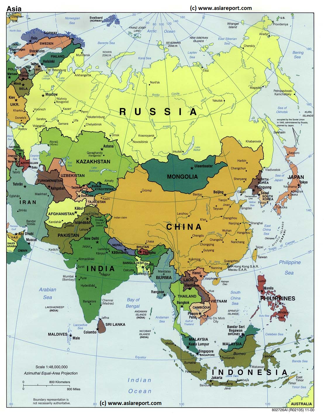
Asia Report - Map of Asia Entire - All Countries, Borders & Capitals
Full Geographical Overview Map of Asia Entire with Zoom & Scroll Functions, Relief Feautures, Oceans, Main Rivers and Capital Cities.
This Map of Asia includes all Asian Countries with Names and Borders, Disputed Border Regions in Asia, Capital Cities of all Asian Countries and Main Rivers and Mountain Ranges.
Click to Go to the Asia Report Main Menu Map, with Zoom and Scroll Functions. Mouse over the Country of your Interest and get short basic information on each Country.
Once more Click through to the Desired Country and Full Information, Photos, Maps and Photo-Virtual Walks of Cities, Towns, Villages, Monuments, Landmarks and Hotspots covered by www.DrBen.Net and www.AsiaReport.com.
SITE INFORMATION UNDER EDITING - MAP AVAILABLE NOW !!
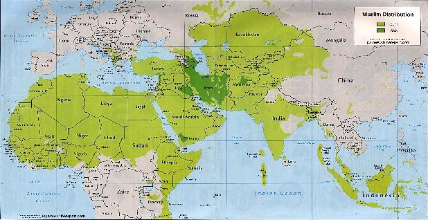
Asia Report - Maps - Distribution Islamic Faith Asia, Africa , Europe
A Demographic Map depicting the Distribution of the Islamic Faith in China and Asia, as well as Europe and the majority of the continent of Africa. Sunni Islamic Areas are depicted in Green, whereas the Shia (Minority) Areas are depicted Darker Green. The predominantly Muslim Xinjiang-Uygur Autonomous Region of China, Parts of Gansu Province and Small Ningxia Hui clearly stand out as the main muslim areas in China.
This page was last updated on: August 26, 2017
My Great Web page
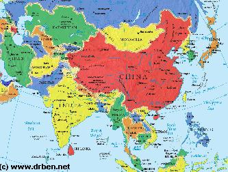
Asia Report - Map of Asia - Political: Mongolia and Bordering Nations of Asia
A Geographical overview Map of Asia entire depicting the current political borders of Asian nations, national Capitals and provincial Capital cities where possible.
This Map focusses on China (P.R.C.) and neighboring Nations of Central, North, East and South-East Asia with National Borders and National Capitals depicted and linked in.
Bordering Nations of the Peoples Republic of China are Bhutan, Nepal, India, parts of Pakistan, parts of Afghanistan, Tajikistan, parts of Uzbekistan, Kyrgyzstan, Kazakhstan, South-Central and Eastern parts of the Russian Federation including the Republic of Buryatia, the Republic of Mongolia, North Korea (D.P.R.K.), South Korea (R.O.K.), Japan, the de facto independent Island of Taiwan (Republic of China) and further the South-East Asian Nations of Vietnam, Laos, Cambodia, Thailand, MyanMar (Bhurma) and Bangladesh.
Map includes names of all Capitals of all 22 Chinese Provinces, Five Autonomous Regions (Inner Mongolia, NingxiaHui,Guangxi Zhuang, Tibet, Xinjiang), Two Special Administrative Regions and Four Municipalities (Beijing,Chongqing, Shanghai, Tianjin).Disputed border regions, the Main Deserts of the Gobi and Taklamakan, steppes and basins, Rivers, Lakes, Sea's and Oceans are included.
- Please browse the Map and follow the links to futher information on each location and destination of your choice. -
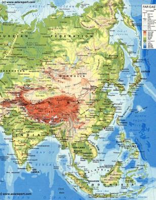
Asia Report - Map Geographic - Relief : Central, East & South-East Asia
A Geographical overview Map of Central, East and South-East Asia. This Relief Map depicts the Nations, Cities and main road and railroad connections.
This general Map focusses on the Republic of Mongolia, The Peoples Republic of China and neighboring Nations of Central, North, East and South-East Asia.
Bordering Nations of the Peoples Republic of China are Bhutan, Nepal, India, parts of Pakistan, parts of Afghanistan, Tajikistan, parts of Uzbekistan, Kyrgyzstan, Kazakhstan, South-Central and Eastern parts of the Russian Federation including the Buryatia and Khakassia Republics, the Republic of Mongolia, North Korea (D.P.R.K.), South Korea (R.O.K.), Japan, the de facto independent Island of Taiwan (Republic of China) and further the South-East Asian Nations of Vietnam, Laos, Cambodia, Thailand, MyanMar (Bhurma) and Bangladesh.
Map includes names of all Capitals of all 22 Chinese Provinces, Five Autonomous Regions (Inner Mongolia, NingxiaHui,Guangxi Zhuang, Tibet, Xinjiang), Two Special Administrative Regions and Four Municipalities (Beijing,Chongqing, Shanghai, Tianjin).Disputed border regions, the Main Deserts of the Gobi and Taklamakan, steppes and basins, Rivers, Lakes, Sea's and Oceans are included.
Please browse the Map and follow the links to futher information on each location and destination of your choice.
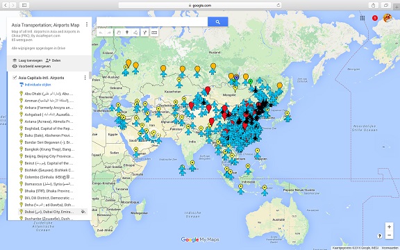
Asia China Mongolia Transportation - Airports & Railroads Satellite Map
This Satellite Image provides an overview of all International Airports in Asia, all Airports in China (PRC) and Mongolia. In addition all military airbases in China (PRC) listed.
Navigate map and click pins for additional information and video where available. Link through from any pin to location information and backgrounds.
Overview all transportation in the Peoples Republic of China and additional Asian Nations in one glance.
Direct Hotel & Resort booking + additional packages linked by location across China, Mongolia and neighboring Asian Nations.
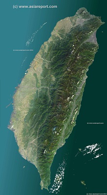
A Satellite Image based overview Map of the Island Nation of Taiwan entire (also identified historically as Formosa, Republic of China or sometimes as Chinese Taipei).
Map includes the entire main Island and several Island groups found nearby however not the Island Group of Penghu, and the Kinmen, Matsu and Wuchiu Island groups which are also claimed by China as part of Fujian Province and also not the Pratas Islands (Atolls)(Chinese: Dongsha Dao) and Taiping Island, a part of the Islands of the South China Sea, in case both claimed by Taiwan ROC and China PRC as parts of their territory and under factual control by Taiwan.
This Map clearly defines Nations, Provinces and Regions, as well as geographical features such as main mountain ranges, famous mountain peaks with heights, main rivers & lakes of the region, basins and plains, plus the locations and names of main cities, towns, monuments and landmarks.
Browse the Map and follow the Links where available to access more maps, information and photos on each location and landmark.
Taiwan Report Report - Map of Taiwan & Island Territories
A Satellite Image Map of the Nation of Taiwan and all Taiwanese Island Territories. This map delineates borders with neighboring Nations of Taiwan; The Philippines, The Peoples Republic of China (P.R.C.) and Japan. Map overviews main Island of Taiwan as well as surrounding Islands giving a Full Overview of all.
Other map features includes visible details of all administrative units in Taiwan, these being Cities, Counties, Districts and Townships, as well as main geographical features such mountain ranges, mountain peaks, rivers, valleys and lakes, name and location details of National Parks and other notable protected nature area's.
Mouse over Image, click map pins and link through to find more information on any map location or feature.
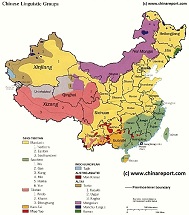
China Report - Map China Ethno-Linguistic / Language Distribution 1964
A Full and complete Map of China (PRC) identifying all Language Areas big and small in all Provinces and Autonomous Regions of China.
Map includes Turkic Languages (Uygur, Kazakh, Kirghiz, Salar & Uzbek), Mongolian Language and Sub-Divisions (Mongol, Tu, Daur and Dongxian), Tungusic Peoples (Oroqen, Evenki and Xibe) and Languages, Korean, Tajik (Tadzhik), Mon-Khmer (Kawa + Puman (or Pulang)), Hui, Uygur (Uighur), Tibeto-Bhurman Languages, Tai and Miao, Yao and She' Language Area's and Borders. Main Area's and sub-divisions of Han Languages (Northern Mandarin, Eastern Mandarin, South-Western Mandarin and Cantonese) further included. This color-coded ethno-linguistic Map (of 1967 AD) identifies at a glance most ethnic minority regions in China.
China Report - Map China Ethno-Linguistic / Language Distribution 02
A smaller rough schematic Map of China (PRC) identifying the Zones of in which the Main Groups of languages spoken throughout the Nation can be easily identified. The 4 main language groups; sino-tibetan languages, indo-european, austro-asiatic and altaic are further subdivided to region, province and Autonomous Regions as based on the 1964 Ethnoc-Linguistic Map.
Map further includes Turkic Languages (Uygur, Kazakh, Kirghiz, Salar & Uzbek), Mongolian Language and Sub-Divisions (Mongol, Tu, Daur and Dongxian), Tungusic Peoples (Oroqen, Evenki and Xibe) and Languages, Korean, Tajik (Tadzhik), Mon-Khmer (Kawa + Puman (or Pulang)), Hui, Uygur (Uighur), Tibeto-Bhurman Languages, Tai and Miao, Yao and She' Language Area's and Borders. Main Area's and sub-divisions of Han Languages (Northern Mandarin, Eastern Mandarin, South-Western Mandarin and Cantonese) further included. This color-coded ethno-linguistic Map (of 1967 AD) identifies at a glance most ethnic minority regions in China.
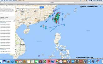
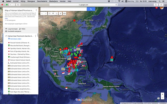
Asia Report - Map of Hainan Island Province including South China Sea
This Google supported Satellite Map provides a clear overview of Hainan Island Province of the Peoples Republic of China, including its South China Sea Prefecture. Map of the South China Sea further includes parts of Taiwan and coastline, Gulf of Tonkin, coastline of Vietnam, Brunei, Borneo (Malaysia), and western Philippines.
Marked on the map for orientation are the names of major National Capitals, locally relevant cities, several towns and villages, names of oceans, islands in the South China Sea, as well as locations of interest such as naval bases, artificial island, airfields, tourism locations, etc.
Browse the map and follow the links to more information, maps and photos of each location.
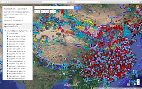
Asia Report - Map of the Peoples Republic of China
This Google supported Satellite Map provides a clear overview of thePeoples Republic of China, including all Provinces, All Cities and all Counties. Marked on the map for orientation are main geographical features such as mountains, mountain ranges, rivers, lakes, major National Capitals, locally relevant cities, all county towns and additional villages, names of oceans, islands in the South China Sea. In addition, transport is highlighted with the location of all International and Local airfields, as well as military air bases, nd train stations (where available). The final layer is reserved for historic monuments, landmarks, tourism locations, etc.
Browse the map and follow the links to more information, maps and photos of each location.