A Menu of all Satellite Image based Maps of Asia and parts there of, available from AsiaReportcom
Make use of the Maps to gain insight and overview of historic events in Asia's Nations, Territories, disputes and 5000 year long history. Regular additions and updates !!
By AsiaReport.com, Travel Guide to China, Tibet & Asia
- Asia Maps Library
Maps of Asia Online - Asia Maps Library
This page was last updated on: 17/10/2017
AsiaMaps.comat
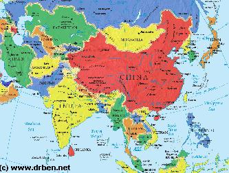
Asia Report - Map of Asia Entire - All Countries, Borders & Capitals
Full Geographical Overview Map of Asia Entire with Zoom & Scroll Functions, Relief Feautures, Oceans, Main Rivers and Capital Cities.
This Map of Asia includes all Asian Countries with Names and Borders, Disputed Border Regions in Asia, Capital Cities of all Asian Countries and Main Rivers and Mountain Ranges.
Click to Go to the Asia Report Main Menu Map, with Zoom and Scroll Functions. Mouse over the Country of your Interest and get short basic information on each Country.
Once more Click through to the Desired Country and Full Information, Photos, Maps and Photo-Virtual Walks of Cities, Towns, Villages, Monuments, Landmarks and Hotspots covered by www.DrBen.Net and www.AsiaReport.com.
SITE INFORMATION UNDER EDITING - MAP AVAILABLE NOW !!
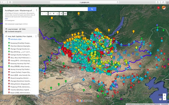
A Full Google Earth Supported Map of Asia (PRC) by AsiaReport.com
Asia Report introduced GMaps on All Levels of its Online Publishing's in April of 2009. Find Google Maps on nearly all Report & Photo Pages where appropriate and useful.
Adjacent Map gives direct access to the Asia Map by AsiaReport.com
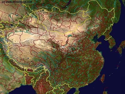
Asia Report - Map East Asia - Prefectures and Provinces.
A Satellite Image Map of the better part of East Asia focussing on the Peoples Republic of China and the Republic of Mongolia.
Map depicts all Prefectures within the Peoples Republic of China as well as the Provinces (Aimag) of the Republic of Mongolia. Further included are parts of neighboring nations of Kyrgyzstan, Kazakhstan, Tuva Republic, parts of Siberia and the Russian Federation, both Koreas (North and South), southernmost Japan, Taiwan, Northern Vietnam, Laos, the larger part of Myanmar (Burma), Eastern India (including Sikkim and Aranuchal Pradesh), Bangladesh, Nepal, the Kingdom of Bhutan, Bangladesh and occupied Tibet.
Browse the Map and navigate through to each City Prefecture, Rural Prefecture or Ethnic Minority Autonomous Prefecture within the Peoples Republic of China today. Full names are given where possible. Map further includes location of main cities where convenient for better understanding of Map and Locations.
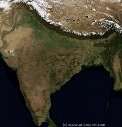
India, Pakistan, Nepal, Bhutan, Tibet AR- SatelliteImage
Overview Map 1A
A Satellite Image based overview Map of India entire, including a large part of North-West Pakistan, Nepal, Bhutan, Bangladesh and Tibet Autonomous Region of China. Parts of Yunnan Province of China and Myanmar (Burma) are also visible. This Map clearly defines Nations, Provinces and Regions, as well as geographical features such as main mountain ranges, famous mountain peaks with heights, main rivers & lakes of the region, basins and plains, plus the locations and names of main cities, towns, monuments and landmarks.
Browse the Map and follow the Links where available to access more maps, information and photos on each location and landmark.
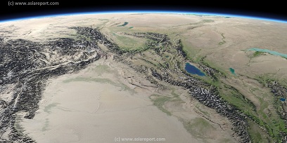
Asia Report - Map Image West Xinjiang AR & Central Asian neighbors
This Satellite Image provides a clear overview of West Xinjiang, Taklamakan Desert, North Pakistan, Afghanistan, Tajikistan, Kyrgyzstan, Kazakhstan and a large section of the (southern parts) Russian Federation.
Marked on the map for orientation are the names of major National and Provincial Capitals, cities, several towns and villages, oceans, sea's, lakes and rivers, as well as mountains, national borders, and locations of interest.
Browse the map and follow the links to more information, maps and photos of each location.
Asia Report - Map Image of Japan, Sea of Japan, Korean Peninsula
This Satellite Image based Map provides a clear overview of most of the Japanese Islands, the Sea of Japan and its Coastline and the Korean Peninsula, including sections of the countries of Japan, South Korea (ROK), North Korea (DPRK), the Peoples Republic of China, and Primorsky Krai Province of the Russian Federation. Marked on the map for orientatation are the names of major National and Provincial Capitals, cities, several towns and villages, oceans, sea's, lakes and rivers, as well as mountains, national borders, and locations of interest.
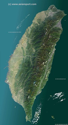
A Satellite Image based overview Map of the Island Nation of Taiwan entire (also identified historically as Formosa, Republic of China or sometimes as Chinese Taipei).
Map includes the entire main Island and several Island groups found nearby however not the Island Group of Penghu, and the Kinmen, Matsu and Wuchiu Island groups which are also claimed by China as part of Fujian Province and also not the Pratas Islands (Atolls)(Chinese: Dongsha Dao) and Taiping Island, a part of the Islands of the South China Sea, in case both claimed by Taiwan ROC and China PRC as parts of their territory and under factual control by Taiwan.
This Map clearly defines Nations, Provinces and Regions, as well as geographical features such as main mountain ranges, famous mountain peaks with heights, main rivers & lakes of the region, basins and plains, plus the locations and names of main cities, towns, monuments and landmarks.
Browse the Map and follow the Links where available to access more maps, information and photos on each location and landmark.
Mongolia Report - Map of Mongolia & Mongolian Territories
A Satellite Image Map of the Mongolia and all Mongolian Territories within the neighboring Nations of the Peoples Republic of China and Russian Federation. Map overviews Mongolia, Tuva Republic and Siberia in the Russian Federation, large parts of Xinjiang-Uighur Autonomous Region, Inner Mongolia Autonomous Region and Manchuria (North and North-Eastern China) giving a Full Overview of all. Clearly visible details of geographical features such as national borders, provincial divisions, mountain ranges, rivers, valleys and lakes, name and location details of Cities and Villages (clearly visible).
Mouse over Image, click map pins and link through to find more information on any map location or feature.
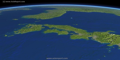
Taiwan Report Report - Map of Taiwan & Island Territories
A Satellite Image Map of the Nation of Taiwan and all Taiwanese Island Territories. This map delineates borders with neighboring Nations of Taiwan; The Philippines, The Peoples Republic of China (P.R.C.) and Japan. Map overviews main Island of Taiwan as well as surrounding Islands giving a Full Overview of all.
Other map features includes visible details of all administrative units in Taiwan, these being Cities, Counties, Districts and Townships, as well as main geographical features such mountain ranges, mountain peaks, rivers, valleys and lakes, name and location details of National Parks and other notable protected nature area's.
Mouse over Image, click map pins and link through to find more information on any map location or feature.