Location : 42°26′ 71.47 North, 129° 21′ 13.49 East
Elevation : --- meters, or ---- feet.
Helong County lies in the northern foothills of the Changbai Shan Mountain range (长白山). As such, the lands are hilly and there are wide variations in altitude. For more information, see: Helong City and County of Yanbian Korean Autonomous Prefecture.
Surface Area of Township: ---- Square kilometers (--- square miles).
Population: The Total Population of Nanping Township of Helong City County is: No Data available.
Nanping is a small, remote and out of the way border town situated due south-east of Helong City on the Tumen River overlooking North Hamyong Province of North Korea (D.P.R.K.). The Town is situated within the Tumen River valley at a modest distance downstream from the North Korean town of Musan (Hangul: 무산), the seat of Musan County (Hangul: 무산군) of North Hamyong Province (Hangul: 함경북도). Altogether, Nanping has a high percentage of ethnic Korean (Chaoxian) inhabitants which is reflected in the many Korean styled houses found mainly at the west side of Town. Currently, Nanping is the location of an official Sino-Korean "friendship
The China Report
The Jilin Report is part of the overall website www.ChinaReport.com & www.drben.net
Learn about what is new on this Site from below window.
The main landmark in the own of Nanping consist of the border crossing station, a huge facility which is situated in the center of town. The main road leads directly up to the border station and on to the slender and outdated bridge into North Korea (D.P.R.K.).
The other "Landmarks" would be the Main Street of Town which runs at a 90 degree angle to the main S202 Provincial Road lading up to the bridge. On the west and north side of town are orean styled residential buildings of considerable architctural interest. Along umen river in the upstream section of town a new square or parading groundis under construction.
A Full listing of Helong City Landmarks, Monuments, Hotspots and other sites of importance in alphabetical order. Search through the list to find your Full Report and Photo-Virtual Tour of each monument or landmark within the City.
There is no railroad station in the Town of Nanping. The main road leads down the valley and then up north-westward to Helong City. The other two roads that lead out of Nanping follow the western river bank of the Tumen River, one heading upstream (south) and one heading downstream (north).
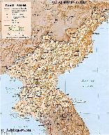
Map of Democratic Republic of North Korea (DPRK), main Cities and Provinces
An overview Map of North Korea (DPRK). This Map inludes Main Cities of North Korea and adjacent regions of South Korea (ROK) and Jilin Province and Liaoning Province of China (PRC).
Further included are Main Roads and Highway Connections, locations of main rivers and mountains, border cities on the Chinese Border and South Korean Border, the 12 main provinces of North Korea, trajectory of Korea's DMZ (De-Milititarized Zone), locations of main historic monuments & tourist sites of the Nation & Region, location of DPRK Main Army and Naval Bases and Yongbion and Yongbion Nuclear facility.
bridge" built in the 1950's and thus serves as an active border crossing point.
Due to to the overall history of the region, its inaccessibility until recently, and the extreme remoteness of Nanping Town even within Yanbian Korean Autonomous Prefecture, Nanping has never been very well known to the outside world. During the time of the Japanese occupation of Manchuria these were the mountainous and forested regions of the border were Korean guerilla's such Kim Il Song could hide out from pursuing troops.
Until at least the advent of the Peoples Republic of China in 1949 AD, and likely for some time thereafter, Nanping was literally the end of the road in what later became Yanbian Prefecture. That is, the one and only road in the wider area led from Yanji City, the Capital of Yanbian Prefecture, southward to Helong Town and from there directly to Nanping on the Korean border where it ended. Around and beyond lay mostly unexplored and undeveloped lands.
Even today, eventhough the road network has improved and railway lines have long been available in the regions, Nanping is not one of the major destinations of the region. The S202 Provincial road was extended to lead south-westward around Changbai Shan and way from Nanping. The political situation in North Korea, a nation which which only little communication exists even from this side of the border, has further discouraged travel to Nanping as no one can venture beyond. As a border crossing point Nanping has been dwarfed in importance by both the main act; the town of Tumen up in the north along the same river, as well as the crossing at Kaishantun, which is far easier and faster to reach from Yanji City.
As for Tumen; a wide highway, able to carry large and heavy military transports, connects from Yanji and its Airport directly through to Tumen City, where there is another strikingly similar "Sino-Korean Friendship Bridge" as well as a railway bridge crossing into North Korea. This is the most obvious border crossing which is therefor also carefully monitored by the Press. In the last 10 years a serious tourist zone, a park along the Tumen River has sprung up, catering to the needs of curious foreigners who come to take a safe peak across the border and see that most intruiging of nations of the earth.
The crossing at Kaishantun in Longjing City County is as yet far less known to the world at large as is Tumen. However, at Kaishantun, due east of Yanji another railway line leads directly down to the border and there is yet again a slender "Sino-Korean Friendship Bridge" leading across the Tumen River. As both Tumen and Kaishantun are far easier to reach from the City of Yanji, where the comfortable hotels are located, most visitors to the border head for these locations.
Thus, although it is the location of a Sino-Korean Friendship Bridge and a wonderful Korean ethnic enclave, the Nanping Crossing and the Town are not a tourist destination and does not receive many visitors. Citizens of Yanji City and area regard it as a far away place. Little news amkes its way out of Nanping to reach the internet.