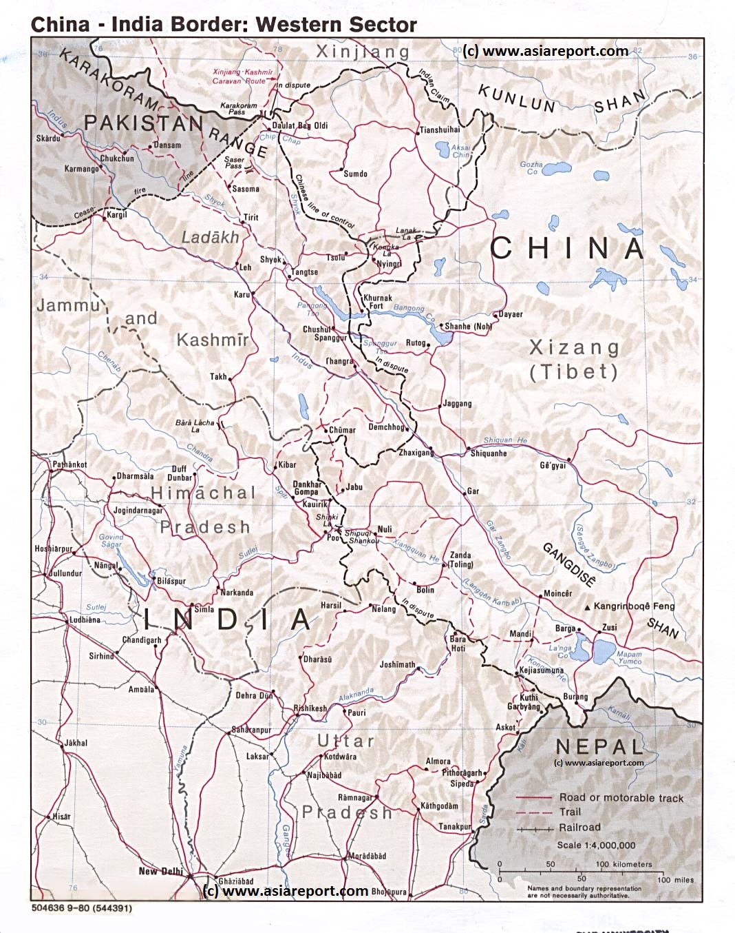
This Schematic Geographic relief Map gives a full overview of the so called Western Section of the border regions between India and China (P.R.C.), more specifically the regions included in this map range between the Pakistan occupied parts of Jammu and Kashmir in the west, the South Rim of the Taklamakan Desert (Kashgar and Hotan City Prefectures) and the Kunlun Mountain Range in the north, Ngari Prefecture in T.A.R. of the Chinese occupied Tibet and western parts of Nepal in the west and the Indian National Capital of (New) Delhi in the south.
Included parts, territories and regions are; southernmost parts of the Karakoram Mountain Range, Indus River Valley in both Pakistan controlled and India controlled Jammu and Kashmir, Ladakh Region, Aksay Chin disputed region since 1962 controlled by China (P.R.C.), Kunlun Mountain Range, Parts of the Altyn Tagh Mountains, parts of Ngari Prefecture of Tibet Autonomous Region, China (P.R.C.)., parts of Himachal Pradesh, Uttar Pradesh and Delhi Capital Territory in India.
Rivers and their basins depicted on this map are numerous, including:
Indus River (in Tibet, Ladakh and Jammu and Kashmir). Today, the along parts of its length, the Indus River represents the factual border between India and China (Tibet, as administered by China (P.R.C.). Special areas of interest in case are the Pangong Lake (or Bangong Co) and areas around the towns of Chushul (Indian controlled) and Demchok in the Ladakh Region.
Other rivers on this map: Chip Chap, Shyok, Spiti, Chandra River, Sutlej River, Yamuna River, Alaknanda, Ganges, Sangge Sangbo River (Chinese: Shiquan He), Gar Zangbo, Xiangquan He and Karnali River in Nepal.
Various of the western Tibetan Lakes are also depicted inside the sparsely inhabited but heavily militarized Ngari Prefecture.
Browse the Map and link through for more information by location where available.
DETAILS OF LOCATIONS OF SPECIAL INTEREST WITHIN XINJIANG-UIGHUR AR ARE HIGHLIGHTED BELOW THIS MAP (scroll down) >>>