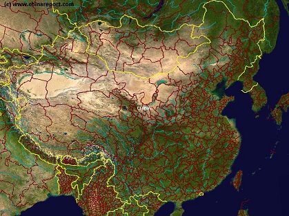
Satellite Image Overview of China (PRC) & Korea at Night + Cities
This Satellite Image provides an overview of all cities and provinces within the Peoples Republic of China and wider Regions.
Locations visible lie roughly between Kabul in Afghanistan in the West, Osaka in Japan in the East, Krasnoyarsk in the North and Sanya on Hainan Island in the South.
Find the large coastal cities and main Chinese Civilization Centres on the Chinese Plains between Beijing i/t North o/t Plains and Hong Kong, Macau and Guangzhou (Canton) in the Extreme South. Follow the Flow of the Yellow River and cities and towns strewn along it from Xining in Qinghai Province, through Lanzhou, Gansu and Yinchuan, Ningxia to flow along the Western Shanxi Province Border and find the black holes created by the Gobi and Taklamakan Deserts as wel as Tibet-Qinghai Plateaux.
China Report - China Satellite Image Based Maps Index
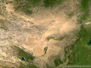
China Report - Map of the Gobi Desert & Yellow River Flow
A Satellite Image Map of the Entire Gobi Desert Region. Map overviews North-West Xinjiang Autonomous Region, Mongolia, Inner Mongolia and North and North-Eastern China giving a Full Overview of the Gobi Deserts. Clearly visible details of geographical features such as mountain ranges, rivers, valleys and lakes.
Map includes country borders, name and location details of Cities and Villages (clearly visible).
Mouse over Image to Reveal more information and follow the flow and path of the yellow river from Xining in Qinghai Province to the Bohai Sea. Details of old / former Yellow River flow (south of new) and new trajectory to the Bohai Sea.
- Online Sources
Maps Of China Online- Space based Imagery
This page was last updated on: 26/8/2017
ChinaReport.comat
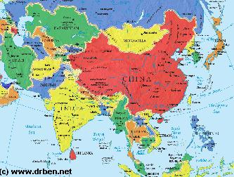
Asia Report - Map of Asia Entire - All Countries, Borders & Capitals
Full Geographical Overview Map of Asia Entire with Zoom & Scroll Functions, Relief Feautures, Oceans, Main Rivers and Capital Cities.
This Map of Asia includes all Asian Countries with Names and Borders, Disputed Border Regions in Asia, Capital Cities of all Asian Countries and Main Rivers and Mountain Ranges.
Click to Go to the Asia Report Main Menu Map, with Zoom and Scroll Functions. Mouse over the Country of your Interest and get short basic information on each Country.
Once more Click through to the Desired Country and Full Information, Photos, Maps and Photo-Virtual Walks of Cities, Towns, Villages, Monuments, Landmarks and Hotspots covered by www.DrBen.Net and www.AsiaReport.com.
SITE INFORMATION UNDER EDITING - MAP AVAILABLE NOW !!
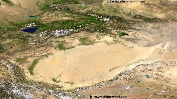
China Report - Xinjiang Maps - Former Lop Nur & Outflow Tarim River
A Satellite Image based Map of the Northern Lop Nor Basin (Former Lake) and the outflow of its feeding River the Tarim He (via the Kunqi River) into the Northern Basin at Lop Nur, Xinjiang Autonomous Region of Western China.
Details of former lake borders, dry river beds, the salt lake(s), dried out swamp area's and moving sand-dunes of the Taklamakan Desert and others are clearly visible. Due to a chronic lack of water during the last century, there are few inhabitants in this area and local villages have all (but) disappeared. No obvious signs of Civilization are visible from above (on this magnification scale).
China Report - Map o/t Taklamakan Desert & Tarim River Basin 1A
A Satellite Image Map of the entire Taklamakan Desert and the Tarim River Basin in Xinjiang-Autonomous Region of Western China.
Map gives explanation and backgrounds to Local Geography, the Flow of the Tarim River from the Pamir Mountains in the West to Lop Nur (Dry) in the East, ancient Oasis Cities of the Tarim Basin and Taklamakan Desert, the North and South Routes of the Silk Road in this Area, Past and Current Climate and Historic Backgrounds.
China Report - Map o/t Taklamakan Desert & Tarim River Basin 2a
A Second Satellite Image Map of the entire Taklamakan Desert and the Tarim River Basin in Xinjiang-Autonomous Region of Western China.
During the Time this Image was taken it was early spring; Mountains were snowcapped and a dust storm is blowing in the Central and Most Arid Regions of the Tarim River Basin.
Map gives explanation and backgrounds to Local Geography, the Flow of the Tarim River from the Pamir Mountains in the West to Lop Nur (Dry) in the East, ancient Oasis Cities of the Tarim Basin and Taklamakan Desert, the North and South Routes of the Silk Road in this Area, Past and Current Climate and Historic Backgrounds.
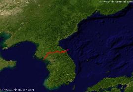
China Report - Jilin Maps - Jilin, Liaoning, North Korea, South Korea Sat. Map
A Satellite Image based Map of the North-Eastern (Manchuria) Chinese Province of Jilin (with parts of Liaoning Province), the Chinese-North Korean Border, Part of Russian Primorsky Krai (Maritime) Province of Siberia in the Russian Federation, and the Nations of North Korea (DPRK) and South Korea (DRK) on the Korean Peninsula.
Mouse over Map includes the Capital Cities of surrounding provinces and Nations, a rough sketched idea of the location of the Chinese-North Korean Border, the location of Border Towns and rivers, main mountain peaks in Jilin Province, cities and villages, the Yanbian Korean Autonomous Prefecture of Jilin Province in China and last but not least the roughly sketched location of the DMZ, the Demilitarized Zone between North- and South Korea established along the 38Th Parallel.
A Full Google Earth Supported Map of China (PRC) by Google.com
The China Report introduced GMaps on All Levels of its Online Publishing's in April of 2009. Find Google Maps on nearly all Report & Photo Pages where appropriate and useful.
Adjacent Map gives direct access to the Peoples Republic of China Map by Google Earth.
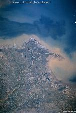
China Report - Map Image of the Mouth o/t Yellow River
A Satellite Image and Map of the mouth of the Yelllow River, China's second largest, at Dongying on the Coast of the Yellow Sea at Dongying in Shandong Province.
Map overviews the last estimated 100 Kilometers of the Yellow River including it final section and mouth. Clearly visible details are those of the Yellow River Flow, nearby Dongying and other villages, industrial area's and ports, as well as currents in the Bohai Gulf and Yellow Sea nearby, due to the waters of Sea and River mixing.
The Yellow River derives its name from the Color it begets from the influx of dust from the Yellow River flow.
View the Full Map and get more information on Dongying and the Yellow River Mouth. Follow the Links on the Map to on site photos and even more backgrounds.
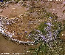
A SatelliteImage overview Map of the entireTibetanPlateauxincluding parts of bordering regions of Xinjiang-UyghurAR, Gansu Province, NingxiaHuiAR, Inner-MongoliaAR,Sichuan Province,andYunnan Province. Surrounding nations and Territories are: Myanmar (Burma), Bhutan, Sikkim, Nepal, Bangladesh, India, Kashmir and Pakistan.
This Map clearly defines Provinces and Regions, main mountain ranges, main rivers & lakes of the region, locations of main cities and landmarks.
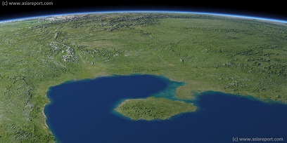
Asia Report - Map Image of South China, Gulf Tonkin, Hainan Island
This Satellite Image provides a clear overview of Hainan Island Province of China, The Gulf of Tonkin, large parts of Guangdong Province, Yunnan Province, Guanxi Zhuang Autonomous Region, Guizhou Province, Sichuan Province and Hunan Province of China; as well as parts of Northern Vietnam, Laos and Myanmar.
Marked on the map for orientatation are the names of major National and Provincial Capitals, cities, several towns and villages, oceans, sea's, lakes and rivers, as well as mountains, national borders, and locations of interest.
Browse the map and follow the links to more information, maps and photos of each location.
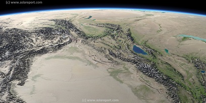
Asia Report - Map Image of West Xinjiang AR & Central Asian neighbors
This Satellite Image provides a clear overview of West Xinjiang, Taklamakan Desert, North Pakistan, Afghanistan, Tajikistan, Kyrgyzstan, Kazakhstan and a large section of the (southern parts) Russian Federation.
Marked on the map for orientatation are the names of major National and Provincial Capitals, cities, several towns and villages, oceans, sea's, lakes and rivers, as well as mountains, national borders, and locations of interest.
Browse the map and follow the links to more information, maps and photos of each location.
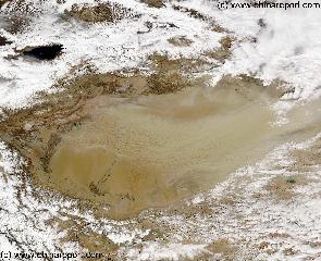
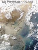
China Report - Satelite Image North-East China, Manchuria, Korean Peninsula
This Satellite Image clearly shows North-East China, Manchuria and the Korean Peninsula, all to varying degrees covered by a Haze of Gobi-Dust Cloud being caried from West to East. Clearly visible are the North-China plains, bordered in the North and East by a semi-continous mountain-range ( Damaqun Shan in the North near Beijing, more south-westernly Guancen Shan near Datong and then further South along the plains Taihan Shan (Luliang Shan ). East of these mountain-ranges are the Yellow River Basin and the Central Chinese Highlands, the Loess Lands of which are the origins of the Yellow Dust. Covering large parts of Ningxia, Henan, Shaanxi and Shanxi Provinces, the yellow river basin is dry and mainly in spring winds gather the dust. Part of the Yellow River's 5000 kilometer flow can be distinguished and is marked on this Map (Better Map Click Here). Names and locations of main cities in China, Russian Federation, North Korea (DPRK), South Korea (ROK) and Japan are marked. Follow the links where available.
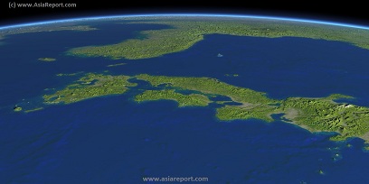
Asia Report - Map Image of Japan, Sea of Japan, Korean Peninsula
This Satellite Image based Map provides a clear overview of most of the Japanese Islands, the Sea of Japan and its Coastline and the Korean Peninsula, including sections of the countries of Japan, South Korea (ROK), North Korea (DPRK), the Peoples Republic of China, and Primorsky Krai Province of the Russian Federation. Marked on the map for orientation are the names of major National and Provincial Capitals, cities, several towns and villages, oceans, sea's, lakes and rivers, as well as mountains, national borders, and locations of interest.
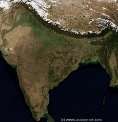
India, Pakistan, Nepal, Bhutan, Tibet AR- SatelliteImage
Overview Map 1A
A SatelliteImage based overview Map of India entire, including a large part of North-West Pakistan, Nepal, Bhutan, Bangladesh and Tibet Autonomous Region of China. Parts of Yunnan Province of China and Myanmar (Burma) are also visible.
This Map clearly defines Nations, Provinces and Regions, as well as geographical features such as main mountain ranges, famous mountain peaks with heights, main rivers & lakes of the region, basins and plains, plus the locations and names of main cities, towns, monuments and landmarks.
Browse the Map and follow the Links where available to access more maps, information and photos on each location and landmark.
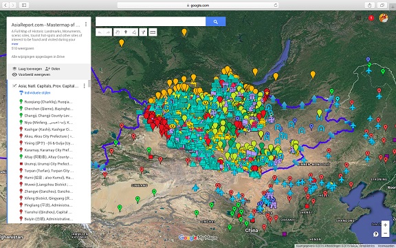
Asia Report - Map East Asia - Prefectures and Provinces.
A Satellite Image Map of the better part of East Asia focussing in the Peoples Republic of China and the Republic of Mongolia.
Map depicts all Prefectures within the Peoples Republic of China as well as the Provinces (Aimag) of the Republic of Mongolia. Further included are parts of neighboring nations of Kyrgyzstan, Kazakhstan, Tuva Republic, parts of Siberia and the Russian Federation, both Koreas (North and South), southernmost Japan, Taiwan, Northern Vietnam, Laos, the larger part of Myanmar (Burma), Eastern India (including Sikkim and Aranuchal Pradesh), Bangladesh, Nepal, the Kingdom of Bhutan, Bangladesh and occupied Tibet.
Browse the Map and navigate through to each City Prefecture, Rural Prefecture or Ethnic Minority Autonomous Prefecture within the Peoples Republic of China today. Full names are given where possible. Map further includes location of main cities where convenient for better understanding of Map and Locations.
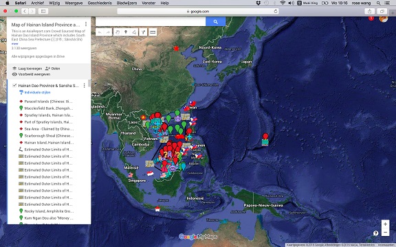
Asia Report - Map of Hainan Island Province including South China Sea
This Google supported Satellite Map provides a clear overview of Hainan Island Province of the Peoples Republic of China, including its South China Sea Prefecture. Map of the South China Sea further includes parts of Taiwan and coastline, Gulf of Tonkin, coastline of Vietnam, Brunei, Borneo (Malaysia), and western Philippines.
Marked on the map for orientatation are the names of major National Capitals, locally relevant cities, several towns and villages, names of oceans, islands in the South China Sea, as well as locations of interest such as naval bases, artificial island, airfields, tourism locations, etc.
Browse the map and follow the links to more information, maps and photos of each location.
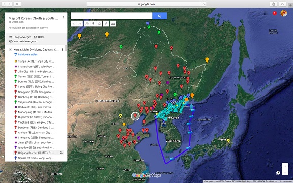
China Report - Jilin Maps - Jilin, Liaoning, North Korea, South Korea Sat. Map
A Satellite Google supported satellite image based Map of Manchuria (Jilin, Liaoning Province) and the entire Korean Peninsula. Map includes details of the Chinese-North Korean Border, Part of Russian Primorsky Krai (Maritime) Province of Siberia in the Russian Federation, and the Nations of North Korea (DPRK) and South Korea (DRK) on the Korean Peninsula.
Mouse over Map includes the Capital Cities of surrounding provinces and Nations, a rough sketched idea of the location of the Chinese-North Korean Border, the location of Border Towns and rivers, main mountain peaks in Jilin Province, cities and villages, the Yanbian Korean Autonomous Prefecture of Jilin Province in China and last but not least the roughly sketched location of the DMZ, the Demilitarized Zone between North- and South Korea established along the 38Th Parallel.
Mongolia Report - Map of Mongolia & Mongolian Territories
A Satellite Image Map of the Mongolia and all Mongolian Territories within the neighboring Nations of the Peoples Republic of China and Russian Federation. Map overviews Mongolia, Tuva Republic and Siberia in the Russian Federation, large parts of Xinjiang-Uighur Autonomous Region, Inner Mongolia Autonomous Region and Manchuria (North and North-Eastern China) giving a Full Overview of all. Clearly visible details of geographical features such as national borders, provincial divisions, mountain ranges, rivers, valleys and lakes, name and location details of Cities and Villages (clearly visible).
Mouse over Image, click map pins and link through to find more information on any map location or feature.
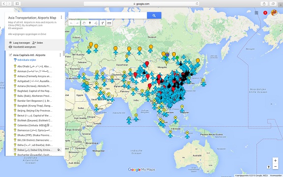
Asia China Mongolia Transportation - Airports & Railroads Satellite Map
This Satellite Image provides an overview of all International Airports in Asia, all Airports in China (PRC) and Mongolia. In addition all military airbases in China (PRC) listed.
Navigate map and click pins for additional information and video where available. Link through from any pin to location information and backgrounds.
Overview all transportation in the Peoples Republic of China and additional Asian Nations in one glance.
Direct Hotel & Resort booking + additional packages linked by location across China, Mongolia and neighboring Asian Nations.
Taiwan Report Report - Map of Taiwan & Island Territories
A Satellite Image Map of the Nation of Taiwan and all Taiwanese Island Territories. This map delineates borders with neighboring Nations of Taiwan; The Philippines, The Peoples Republic of China (P.R.C.) and Japan. Map overviews main Island of Taiwan as well as surrounding Islands giving a Full Overview of all.
Other map features includes visible details of all administrative units in Taiwan, these being Cities, Counties, Districts and Townships, as well as main geographical features such mountain ranges, mountain peaks, rivers, valleys and lakes, name and location details of National Parks and other notable protected nature area's.
Mouse over Image, click map pins and link through to find more information on any map location or feature.