Backgrounds o/t Tarim River Basin and Taklamakan Desert :
This page was last updated on: May 24, 2017
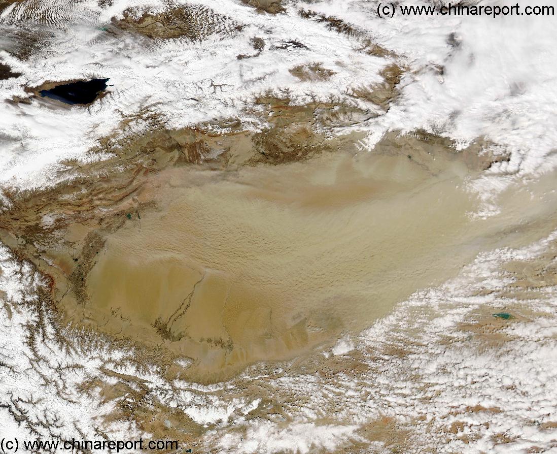
This Satellite Image Map gives an of the Tarim River Flow Area and the Taklamakan Desert in Xinjiang-Uygur Autonomous Region (and Gansu province) of North & Western China during a Spring Sand Storm. Scroll Up & Down, left and right to view the Entire Tarim River Flow, the Sands of the Taklamakan Desert and surrounding Mountain Ranges, which contribute for a large part to the local Climate, upwelling Oasis, Fast Running Rivers and Dry Desert conditions.
In Counter-clockwise direction The Taklamakan Desert and Tarim River Basin are bordered in the North by the Mighty Tian Shan Mountain Range on the other side of which lie Tajikistan and Kyrgyzstan. Upwind in the West lie the Pamir High Mountains and Mountain Plateaux, and the high mountain gateway into wild Afghanistan. In the South-West the River Basin and Desert are bordered by the Karakoram Range, an extension of the Himalayas and among the highest mountains in the world. On the other side lies
The China Report
Introduction to Satellite Map o/t Tarim River Basin and Taklamakan Desert -2A
The Taklamakan Desert is enclosed by Mountain Ranges in 3 directions, limiting its Sand Flows to the Tarim River Basin and Area's West and Down-wind in Gansu Province.
The Tarim River source is found in the Pamir Mountains in the extreme West of the Basin and this Image as the Kashgar River. It then flows past Kashgar, to turn North and East and flow along the North Rim of the Basin underneath the Tian Shan Mountains. Here the Aksu River joins up from the North, creating the 5Th Largest River in China (P.R.C.). The River Tarim follows the northern rim to end up in the North-East Corner of Lop Nur, where the Lost City Ruins of Loulan (Shanshan) are located.
Today Lop Nur is a dried empty Salt Bed of the former Lake. Earlier in history, in the 200 BC to 1000 AD Era Lop Nur was a large lake with adjoining marsh area's rich in fish and game. It hosted a rich and powerful Kingdom located strategically on the Chinese Section of the Silk Road. Loulan lasted, as a Chinese Protectorate through
Mountainous North Pakistan. Along the South, the Altyn Tagh Mountain Range provides a natural border with Tibet Autonomous Region of China. Last, in the East lie the remnants of famous Lop Nur, now dry and Salted. Lop Nur was the ending point of the
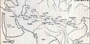
Map 1 of the Silk Road during the early Tang Dynasty Era. Clearly depicts the North & South Routes West of Dunhuang as well as the lost civilizations of Loulan and Hotan.
the powerul and expansive Tang Dynasty to beyond 1000 AD, after which climate conditions deteriorated. The flow of the Tarim River was changed many times in history, due to the shifting Sands of the Taklamakan Desert. As a result somewhere after 1000 AD Lop Nur slowly dried up and the Loulan Civilization, the Large Lakes, extensive swamps and wildlife were lost to Time (until 1899/1900 AD). Upstream Oasis Cities along the South Tarim River Basin rim suffered similar fates between 1000 AD and Today, although some Villagers and Remnants of Villages remain until this very day.
Today's Taklamakan Desert is even dryer than in the Past. During the heydays of the Han and Tang Dynasties, roughly between 200 BC and 1000 AD the Tarim River Basin supported not only Lop Nur but a string of Rivers along its Northern Rim, as well as its Southern Rim. Hence, the Tarim River Basin became the main route of the Silk Road in China. The Chinese
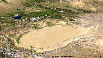
China Report - Map o/t Taklamakan Desert & Tarim River Basin 1A
A Clear Sky Satellite Image based Map of the entire Taklamakan Desert and the Tarim River Basin in Xinjiang-Autonomous Region of Western China.
During the Time this Image was taken it was early spring; Mountains were snowcapped and a dust storm is blowing in the Central and Most Arid Regions of the Tarim River Basin.