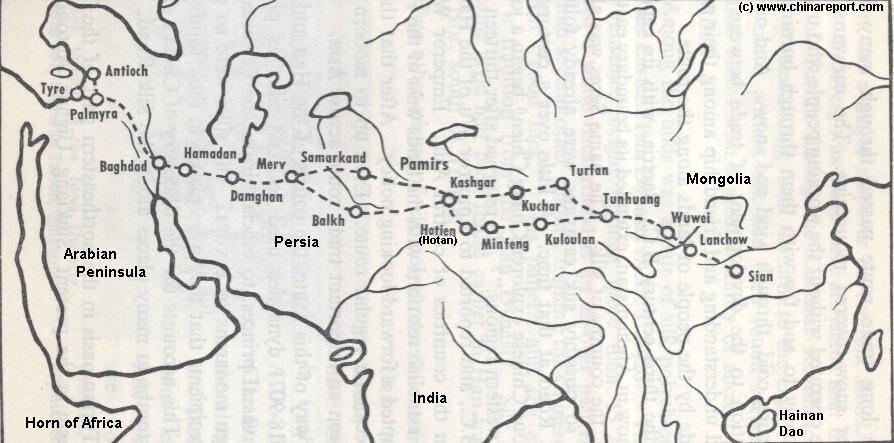
Most notable features of this specific map is the depiction of the split of the Silk Road into a North Route and South Route, west of Dunhuang in current day west Gansu Province. The North Route of the Silk Road historically passes from Jade Gate & Yu Men Pass along the flow of China's 5Th largest River, the Tarim, to pass by the Oasis of Turpan in current day Xinjiang Autonomous Region on the way to Kochar and Kashgar beyond. The South Route follows the Northern Edge of the Tibetan-Qinghai Plateaux from Yang Guan Pass - Sun Gate near Dunhuang, passing the forgotten cities of LouLan and Hotan on the way to Kashgar in Xinjiang AR and the Pamir High Mountains of Afghanistan.
The two routes rejoin at Kashgar. From Kashgar it was through Balkh in current day Afghanistan, still a restless tribal area, or more Northernly through Samarkand and Buchara in current day Uzbekistan, into Persia and on to the West.
Not depicted on this Map is the southern arm of the Silk Road, leading away to Pakistan and India's Ganges and Indus Valley's in the far South. A Later Silk Road bypass from Loulan in Lop Nor forming the South Route via Tibet into Nepal and India is also omitted as it was not yet in existence during the Han Dynasty but started operating in earnest in the 7Th Century during the Tang Dynasty.
The China Report
Map China - History - Silk Road 1 Early Han Dynasty Period
Lhasa
Gobi
Taklamakan
Gobi
Gobi
Tarim Basin
Hexi
Corridor
North
South
East
Designates Chinese Controlled Territory
ChinaReport.comat
The first Westerner to Explore and report on the full length of the Silk Road was Marco Polo (1254 AD - 1324/25 AD) who entered China through
Designates Persian Controlled Territory
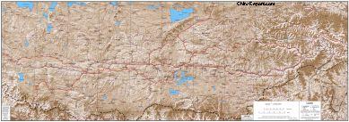
China Report - Tibet - Relief Map of Central Tibetan Plateau
A detailed Relief Map of Tibet - The Central Tibetan Plateau depicting the Main Cities and Roads in Tibet. Includes the Location of Mount Everest on the Tibetan-Nepalese Border.
Beijing) the Yuan Dynasty Capital at the Time. Marco Polo noted the 1000's of Buddha Statues and Murals near this Oasis (Mogao Caves) in his book "Il Milione" (Or Marco Polo's travels) making them world famous.
Many would follow in his foot-steps in Centuries after. Moroccan Ibn Battuta followed in the 14Th Century. The next famous western explorers
that we know of, came many centuries later during the 19Th Century. During this Time several explorers were active among whom a Russian and the Svedish Explorer Sven Hedin pushed deep into Central Asia. Hedin was the first to create detailed Maps of Tibet, the Pamir Mountains and the Taklamakan Desert. During one of his voyages (1899) in the Western Deserts Hedin re-discovered the ancient lost civilization of LouLan, an oasis Kingdom
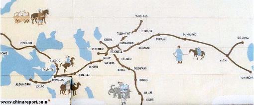
A 2nd Schematic Map of the Silk Road during the Roman Age. In 30 BC the Roman Empire started trading with India, which was already well known from the Conquest of Alexander the Great (+/- 330 BC). In the following 6 centuries the West would Trade with India and indirectly also with China through the Silk Road. The Silk Road only lost its Value after the European Age of Discovery and the Establishment of Maritime Trade Routes with India (16Th Century) and later China.
during the Han Dynasty Silk Road Era. Up to that Moment the City was lost for a 1000 years.
Designates Current Day Syrian Territory
Tian
Shan
Caspian
Sea
Lake Balkash
Aral
Compare Maps to explore the Silk Road - Follow Links to more Information & Photos on each Location !