Zhangye has a continental climate with the average sunlight of over 3000 hours annually.
Temperatures are the lowest and days and nights coldest in January, the hottest days of the year usually fall in July. The comfortable months for travel are from June to September, which is the Tourist High Season. Days may remain sunny throughout November counting chilly nights, nippy mornings and warm afternoons.
Average Temperature in Zhangye: 7 Degrees Celcius annually. Temperatures may range between Minus 20 Degrees Celcius and near + 40 Degrees in July.
Rainfall: Annual rainfalls are low with an average rainfall of 129 mm (Range: 104 millimeters-459 millimeters (4 inches-18 inches)) per year. Local agriculture and life depends on the waters of the HeiHe or Hei River, the Shandan River and local aquifers which derive their waters from the melting waters of Gletsjers on top of the Qilian Mountains.
Although water flows easily from fossets inside the luxury hotel rooms of today's tourists who drop into town, the outlying villages of Zhangye Prefecture have only resently been supplied with clean and fresh water. The struggle is however ongoing.
Lately, rainfall at Zhangye, inside the Hexi Corridor and in the wider regions of North and Western China have been decreasing. The last 3 years have seen a drop in rainfall leading to widespread droughts.
For the future of Zhangye, water conservancy and prevention (if possible) of climate change will be of the utmost importance. Save your water when visiting Zhangye !
Travel tips for Zhangye City and Prefecture: the abundance of clear skies and sunny days inside the Hexi Corridor bring with them the downside of an easy chance at an overdose of solar radiation. First thing to bring along on your trip are sunglasses (shades). Some high factor sun screen oil may also be put to good use, especially in the hottest month, july.
Uh-ooh, how did you say: Stop this Bus in Chinese, again ??!!
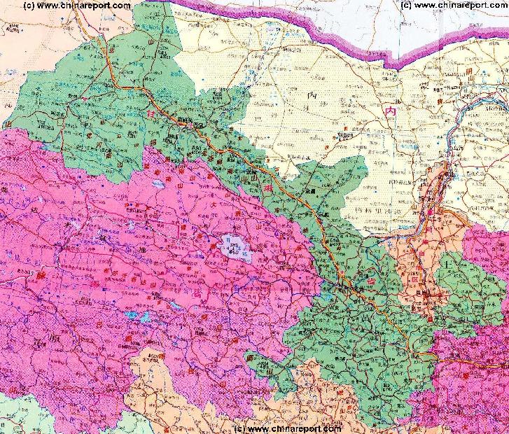
A Maps Index Page providing link to All Geographic & Historic Maps, Satellite Images and other Map materials on Zhangye City & City Prefecture, the National Highway 312 (Shanlin expressway or Lanzhou-Urumqi Highway), the Silk Road and Great Wall of China nearby Zhangye.
Furthermore this Map offers Link through to additional information and photos on Landmarks, Monuments and Sites of interest in Zhangye, Zhangye Prefecture and all related Regions of Gansu Province and China.
Map updated regularly with new Destinations !!
This page was last updated on: July 22, 2017
The Zhangye Report
Introduction to Zhangye
Zhangye Landmarks & Monuments
Zhangye & Area Maps
To be exact Zhangye City Prefecture consist of a central urban district which is the City of Zhangye, surrounded a 5 counties under its administrative responsibilities. Zhangye has been historically known as Ganzou since the Western Han Dynasty Era and is thus designated as Ganzhou District (甘州区). Apart from te City of Zhangye there are 4 counties plus one autonomous county. The 'regular' counties are Linze County (临泽县), Gaotai County (高台县) , Shandan County (山丹县) due East of Zhangye City located along Highway 312 , Minle County (民乐县). The one non-regular but Autonomous county
The China Report
The Zhangye Report is part of the overall website www.ChinaReport.com & www.drben.net
Learn about what is new on this Site from below window.
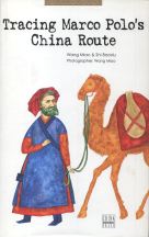
The beautiful Photo-Journey of Wang Miao and Shi Baoxiu, all the way from the Pamir Highlands in Central Asia, through North China to Beijing along the Silk Northern Route. A jewel of a Book !!
ChinaReport.comat
Among the many landmarks of Zhangye City and Area, the most renowned and readily available is its Great Buddha Temple (or Big Buddha Temple) which has a Towering Pagoda dated over 1400 years old, as well as a giant recling buddha statue. Find the Temple at the South End of town where it has 'always' been.
A Drum Tower dating from the Ming Dynasty (1368 AD - 1644 AD) stands at the Center of Town, making navigation easy. It's features are distinctly Ming, solid and otherwise not very remarkable.
Other more impressive ancient landmarks include the World Cultural Heritage Mati Si Buddhist Caves and their uniquely preserved Cave Art at Sunan, a relatively under-advertized section of the Great Wall of China, and then some other ancient Temples with remarkable architectural features and great historical value.
Zhangye City landmarks dating from a far more recent history include first and foremost a Monument dedicated to a part of the revolutionary Red Army that perished in 1935 AD during a lesser known episode of the Long March now known as the "Ningxia Campaign".
Zhangye is not merely known for its spectacular historic landmarks but also for its unique landscape and scenery. Bordered by the mighty Qilian Shan mountain range with tops going over 5500 meters, Zhangye lies surrounded by surprising green lands. Where horses graze on the Damaiyin Pasture Lands underneath the mountains, Egrets fly over the Heihe wetlands of Gaotai County in Zhangye City. The Hei River and its (once) extensive wetlands of Zhangye lie on an important migration route and its abundant waters in otherwise arid regions provide an essential stop-over on the way across the continent.
Much has been done by the local People and Provincial Authorities to preserve the natural variety of this special place leading to a recent increase of the Bird Population. Many come to Zhangye just to see them and enjoy their wild beauty!
A third spot of natural scenery is the complete opposite of this. At Danxia Landforms park there are only rocks and desert. The eroded hills make for colorfol patterns and are among the spectacular spots of the area.
A Last popular place to visit at Zhangye is its famous Horse Farm, the largest Army Horse Breeding Farm in China. The Farm is not located at Zhangye City but can be found due South-West of Zhangye, and 55 kilometers south of the historical Town of Shandan, just 66 kilometers East of Zhangye along Highway No.312 (Lanzhou-Urumqi Highway).
Click through to Learn all the specifics on Zhangye City & Prefecture Landmarks !
Zhangye Transport
Zhangye has no less than 3 railway stations. The main railway station is Zhangye Nongchang Si Station. Another option is to travel along the main Lanzhou-Urumqi Railway to Laosimiao Shoufei Station, which lies along the No. 312 National Highway. Take a Taxi from the Station and head along the highway just a small distance to end up at the Old City Center of Zhangye.
Bus Station and Destinations:
The Bus Station is known as Zhangye Nanguan Coach Bus Station. From Here one can take Buses to reach throughout the prefecture and wider Region. Among the destinations: Sunan, the Home of the Yugur Minority, which is also the place from which one can travel on by Taxi to the world famous Mati Si Buddhist Caves. Other directions, East to Shandan and West to Jiuquan and Jiayuguan.
The Eastern Bus Station, which is located south down Donghuan Nanlu from the Hexi Hotel, dispatches buses in the evening to Lanzhou, 3 of which are with sleeper seats (Y90 /15 hours). Buses leave every morning to Jiayuguan (Y25 / 5 hours) from this same Station.
Buses departing from the Southern Station head to Jiayuguan in the morning and Lanzhou in the early evening.
From Zhangye it is also easy to travel south into Qinghai Province. Buses follow the route of Highway G 227 to travel into the Mountains and via the vicinity of Mengyuan, to Datong and on to Xining, the capital of Qinghai province. The distance to this destination is just 347km, a small distance in these far flung regions. The Buses heading to Xining leave from the Xiguan Bus Station on Paoxuanlu for Y32, twice daily.
Air-Connections:
There is no airport. The nearest Airport is at Jiayuguan further West in Gansu. The second option is to head East to Lanzhou Tianzhu' National Airport much farther away.
Railroads, Railway and Station:
The Main railway station is located a small distance North-East of Town at the village of Taipincun, which is connected by a Main Road to the City Center. This leaves the Station at a distance of some 6 kilomters to the exact Center of Town, the Drum Tower.
Local mini-buses shuttle travelers back and forth to town for about Y3, take a Taxi and spend around Y10 to 15 for the Ride.
Zhangye is a major Station along the Lanzhou-Urumqi Railway Line. Each day there are a few trains traveling to and beyond Zhangye in both directions. As blessing for travelers the entire railroad has recently been modernized, resulting in better and faster connections. Now there is a nightly express train that leaves Lanzhou at about 10pm and arrives in Zhangye some 12 hours later.
Anyone intending to travel further west to Jiayuguan can travel there in about 4 hours by train. Other local trains leave regularly for Jiayuguan to the West or Shandan, Wuwei and Lanzhou beyond in the East. A slow train to Jiayuguan will take around 9 hours, a considerable time during which one can admire the scenery or enjoy some sleep.
Getting tickets at the Zhangye station can be a bit of a tricky business, especially outside of tourist season. Things are best arranged via the front desk of your local Hotel, who will be happy to help you, or via the Train Station itself. A good second option is the local CITS, China International Travel Service Office.
Road-Connections:
China National Highway 312 from Lanzhou to Urumqi, also known as the Shanlin Expressway, passes Zhangye immediatly south of Town, and continues East via Shandan and Wuwei, via the Lanzhou's National Airport at Tianzhu' to Lanzhou. The distance to Lanzhou is about 450 Kilometers. The Highway 312 leads West from Zhangye, to JiuQuan and Jiayuguan, then on to Yumen and Anxi and into neighboring Xinjiang-Uygur Autonomous Region. It ends far away at Yining in Xinjiang-Uighur AR, near the border of The Republic of Kazakhstan.
A second major traffic artery in the Region, China National Highway No. 227 (G227) runs from Zhangye (roughly) southwards into neighboring Qinghai Province and up to the Tibetan High Plateaux to end at Xining the Capital of Qinghai Province. This road is 347 kilometers in length and passes along a number of mountainous regions where various minority goups make their home. Among the main ethnic capitals along this road is Mengyuan in Qinghai. In the wider vicinity of Town live the Tu, Yugur and Salar Minorities.
As for Zhangye City Prefecture the highest altitudes are found in southeast where the highest Top of the Qilian Mountains reaches 5,564 meters (18,254 feet). The lowest point within Zhangye Prefecture, at 1284 meters (4,212 feet), is found in the northwest.
Surface Area (of County): 40,874 Square kilometers (16,177 square miles).
Population: The Total Population of Zhangye City Prefecture is around 1.260.000, of which the urban citizens of Zhangye City count a total of 260.000.
Moon
Canyon
Today's Zhangye has been doing remarkable well in recent years.
The southern Skyline of the ancient Town is still dominated by the ancient wooden Pagoda of erected as the pride of the town, 1400 years ago during the Sui Dynasty (589 AD - 618 AD).
Due to the abundant waters and irrigation from the Black and Shandan rivers Zhangye is a good spot to sustain agriculture which has been quite developed here for millenia. A green homeland at the beginning of an increasingly bleak silk road and an unusual Oasis in these western regions throughout most of its history Zhangye has gained the name of having "lush southern-type fields in the desert". It shares this reputation with other such Oasis, like Zhongwei on the Gansu Province-Ningxia AR Border and various other green spot along the desert and Yellow River flow trajectory.
Zhangye, known for its green and lush landscapes is one of 12 national key commodity grain bases of China. In fact, for centuries the Town has been almost mythically known as a beautiful and richly endowed place in the otherwise rugged
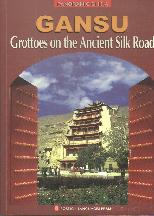
Source Book
"Gansu - Grottoes on the Ancient Silk Road"
( available from our Online Store )
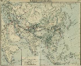
Map of China during the Rule of the Han Dynasty (206 BC - 221 AD) with the main trading roads of the Empire, the Silk Road and location of Huixian marked.
Zhangye City Prefecture, which is the wider administrative District of the Province with its Capital at Zhangye, borders on Inner-Mongolia Autonomous Region in the North and North-West, and on Qinghai Province in the South and South-West.
In the North the border is formed by Heli Mountain and Longshou Mountain, where as in the south the borders of the administrative district are formed by the Qilian Mountains, who in turn are the Outermost Layer of Mountains belonging to massive the Tibetan Plateaux. Qinghai Province of Today is essentially the Eastern Half of the Nation of Tibet. Hence, the multitude of Minorities in the wider Region.
Zhangye (simplified Chinese: 张掖) is a silk road city located inside the Hexi Corridor which naturally shapes the borders of Western Gansu Province. Due to its elongated shape this corridor was thus also known as "The neck of China".
Surrounded by flat lands with lush green and abundant water in an otherwise Mountainous Region, Zhangye is of unique scenery giving rise to the local saying: "If you didn't look at the Snow on the Qilian Mountains you would mistake it for a place along the South Bank of the Yangtze (River)".
Although the majority of the Hexi Corridor is flat, forming a perfect highway corridor between otherwise near impassable mountains, the location Zhangye is an especially auspicious spot including two rivers and an aquifer spring oasis. The main river in Zhangye Prefecture is the HeiHe, the Black River. The Hei River is also known as Ejin River. The second river is the Shandan River.
As summarized in short above, Zhangye City knows quite its history. In fact, it was founded over 2000 years ago, officially during the Han Dynasty, but probably long before.
During the early Han Dynasty Zhangye was no less than the Capital City of the North-Western Regions of China, and thus it became the corner-stone and stepping-off point for the Han Dynasty Emmissaries who would help explore, found and later dominate the trading routes that would become famous in history as "The Silk Road".
Already during the succesful years of the Han Dynasty, "China's first Golden Age", Zhangye grew to be
A Schematic Map of the Eurasian Trade Routes existing in the 13Th Century. Clearly marked in Red Accent on the Map are the cities of the network of land-bound trading routes through Central Asia known as the Silk Road (the path of Marco Polo and others).
You Tube Video - A Drive through Zhangye and beyond
Hexi Corridor owing it the nickname "Golden Zhangye".
Products: Chinese date, apple, pear, garlic, honey, wine, cashmere, and lately potatoes.
A relatively new feature of Zhangye is "European Street," on which the buildings are supposedly built in a European style. The Street includes a modern Marble Statue of Marco Polo. A couple buildings have a European-inspired facade, but the street's way too wide to be European, and the buildings were built quite hastily. Still, not unpleasant to the eye compared to other sites in Zhangye.
Head to the eastern part of Town to find the somewhat acclaimed Ganchuan Snacks Street or Market Street. At this friendly spot one can try various local snacks and cuisine, adding a multitude of flavors to your cultural experience. The place is open virtually 24-7, opening at 6 AM and lasting until about 3 or 4 in the morning.
Zhangye City, Gansu Province, Shandan County, combined with study and practice to carry out the scientific concept of development activities, the county-depth analysis of the situation, based on the actual work, the scientific integration of various types of agriculture-related projects, steadily pushing forward the pilot work of new rural areas throughout the county.
In the potato industry, the county completed an area of 13 hectares, focusing on the promotion of a soil test ridge Fertilization and two furrow irrigation water-saving production technology, large-scale implementation of a national commodity grain base in the construction of high-quality potatoes, seed-breeding base construction and the original species breeding net cellar storage shed and construction projects, and gradually building a standardized production base, create high-yielding mu
demonstration base, the breeding of special potato seeds.
Grapes are a more traditional product which has received attention. In terms of facilities, a standardized grape canopy model has been adopted and currently over 157 sections have been covered.
This is also important in terms of the Province Wide water conservancy project.
In order to use water more efficiently the Government recently the completed a large scale investment of 5.48 million yuan in Zhangye's rural areas to improve access to clean water and expand its safe drinking water projects.
It is hoped that this will solve the drinking water security issues in three rural township's near Zhangye City.
Famous for and relying economically on its important agriculture, Zhangye City and Prefecture have seen continued construction of large irrigated areas and water-saving transformation project during the year 2008 and 2009.
26 kilometers of new irrigation channels have been dug and prepared during this Time.
A total investment of 9.12 million yuan to complete the Temple ditch, two water reservoirs in the mouth reinforcement task. 10.15 million yuan of investment to start the construction of the main stream of Maying River ecological control of soil and water conservation works, water and soil erosion area of 24.75 square kilometers; cattle and sheep industries, the new District 3 sheep breeding, the development of two villages sheep, professional agency 8 months, adding 50 more than 160 big sheep, keeping sheep fattening county amounted to 1,150,000. Standardization of the establishment of beef cattle farming village model 2, model 20 households, the construction of four residential cattle, add three more than 106 households in the size of cattle, a total of 1224; urban-rural integration, the completion of 18 new rural pilot the village planning and design work, the year 3000 mission of rural transformation危旧房; rural roads, built 60 kilometers of secondary roads, rural road 60 kilometers pass, pass the village of Highway 100 km.
Local delicacies are: Wujiang Rice, Zhangye Wine made of local grapes , Xiaohe Chinese Dates, Mingle Garlic, Huangsheng, Rape Seed, Gaotai Capsicum. Unhealthy local products: Zhangye Rice Wine (Zhangye huangjiu), Zhangye Nan Wine (Zhangye nanjiu) and Siluchun Spirits (Siluchun baijiu).
Traditional handicraft products include the caracteristic papercuts of Zhangye and Region, various local styles of embroideries.
In the northwest of the downtown area, Ganquan Park leads people to believe they are in the classical gardens of Suzhou. Wandering in the Zhangye Forest Park, one sees boundless mountains and successive dunes in the distance and enjoys the sunshine on the beach. The largest horse farm in Asia, Shandan Horse Farm is situated in the majestic Mt. Qilian. In summer, Hongyashan Reservoir is an ideal place to escape the heat. All of these make a trip to Zhangye unforgettable.
Zhangye yearly holds its Mati Si Temple Tourist Festival, other than that there is the Minghai Desert Travelling Festival and the Wenshu Temple Fair.
Zhangye City Prefecture counts no less than 26 ethnic groups apart from the National majority, the Han People. Among the many, the largest ethnic communities are formed by the Hui, the Tibetans, the Uygur, the Zhuang and the Yugur.
85% of all Yugurs in China, some 35.000, are living within Zhangye City Prefecture, of whom most are concentrated at Sunan Yugur Autonomous County (肃南裕固族自治县), of which the main town and administrative Capital is Hongwansi Town (红湾寺镇).
Sunan County counts a surface area of some 20,456 Square Kilometers and has over 10 indigenous minority ethnic groups. The main Ethnic Groups in Sunan are Yugur, Tibetan and Han. The rare Monguor are also represented.
The only other autonomously ruled ethnic enclave of the Yugur can be found at neighboring Jiuquan City, more to the West, where some 15000 Yugur live at Jiuquan Huangnibao Yugur Autonomous Township. Inside of Sunan County lies another ethnic enclave Xishui Tibetan Township. Xishui is a majority Tibetan Town, but other ethnic identities share this hometown.
One of the main Tourist Hotspots and historic Monuments of Zhangye Prefecture, the Mati Si grottoes is situated in Sunan Yugur Autonomous County, located at some 62 kilometers distance from Zhangye City. The spectacular features of this tourist zone do not only include the Mati Si ancient buddhist cave arts but also the national protected scenery of prairies and forests above which the beautiful snow-covered tops of the Qilian Mountains. After admiring the scenery and spectacular cave arts, one can easily head over to Sunan and have a meeting with the Yugur People, to enjoy their colorful wares and many other cultural traits.
Besides the unique nationality culture, Zhangye yearly holds its Mati Temple Tourist Festival involving lots of Buddhism and even more Yugur Culture which attract thousands of tourists from home and abroad.
Xishui Tibetan Township today has a surface area of 894 square kilometers and counts 5 ethnic groups. They are the Tibetan, Yugur, Hui, Mongol and the Han. Tibetans amount to over 90% of the township population and members of other groups all have kinship relations with them. At this remote location, the ethnic community is very close knit, and it can be said that "everyone knows eachother". With the Tibetan, Mongol and Yugur cultures historically dominated by Buddhist influences, the local culture of Xishui Township is overwhelmingly Tibetan. Historically, different ethnic groups in Zhangye intensively interact with each other. As a result, it is one of the model area's in China where the harmonious cultural landscape of multiethnic coexistence preached by the Government is achieved to a large extend. Naturally, economic strains and enlarged mobility with influx of migrants can cause stress on local regulations and political wishes.
The Holy Mountain of the Xishui Township people and Sunan County is the Da Gu Shan, which carries no less than 3 pagoda's atop its Icy ridges. Long undisturbed as the guardian of the Town, Dagushan has recently seen the roar of Chinese development arrive.
Xishui Tibetan Township is currently the location of the Xiaogushan Hydro-electric Power Project, a damming project of the Hei River. The proposed aim of this Project is to alleviate the increasing power shortage in Zhangye city and the Hexi Corridor. Usually, when there is not enough power, lights in the City will remain on, however the rural area's are cut off from electricity. It is hoped that with the building of the Dam enough electricity can be generated to make continued economic development of these far western regions possible, and include each rural village. Naturally, ensured supply of electricity is a base necessity for development of village economies and the fighting of rural poverty in Gansu Province.
(Persian Ambassadors to China,active since the 7Th Century AD, had earlier use the name Kam-Giou for the same Town).
Much has been made of the fact that Marco Polo didn not just stop for replenishments but (according to historians) stayed at Zhangye for one whole year. Thus, as one of the rarer sections in his travel decriptions, Marco Polo describes more than only landmarks, local products and the route he traveled in- and out, in this case he discusses the religions of the Town and mentions the existance of Christians there. According to Marco Polo there were no less than 3 Christian Churches in Town around the year 1270 AD. However, no proof of their existance at Zhangye has ever been found. It is currently believed that the churches did exist but were constructed of wood, hence no significant remains can be found today.
It is almost euqally unclear what happened to the Chistians at Zhangye. After Marco Polo's journey the ruling Mongol Yuan Dynasty with tolerance towards
Ethnic Minorities was exchanged for the far less tolerant Ming Dynasty who ruled from 1368 AD to 1644 AD. It is known that the Ming practiced an active policy against foreign religions, hence both Lamaism and Christianity were outlawed. As during the founding years of the Ming Dynasty the various Islamic Groups centered around Kashgar and the Taklamakan Desert had grown very numerous and active, it is likely that the Christians and probably Tibetans were annihilated in religious warfare.
Perhaps we shall never know the answers. The mention of these Christians in the far East, however, would later arouse much interest and resulted in heated debate in Western European Nations whether or not those Christian were surviving remnants of the Great Empire founded by Alexander the Great, or where somehow converts of other Missions on the Silk Road. Eventually, various daring explorers set off to locate these Lost Christians in the East and solve various other open questions that had arisen from the sparse information provided by Marco Polo and very few others.
Other words of Marco Polo reveal some details on the many buddhist inhabitants of the Town and Region. In this manner Marco Polo describes the many buddhist monasteries including the Big Buddha Temple of Zhangye. What is less mentioned by the local tourist authorities is the fact that Marco Polo also bluntly stated that the local citizenry behaved "like animals". The observation that sparked this emotion was the fact that local Men could have many wives, as many as thirty depending on financial means. Marco Polo was especially offended by the fact that Men could have intercourse with any woman, no matter if she was a close relative or not. In fact, according to him incestuous relations were considered quite normal.
A last credit is given to Marco Polo for (apparently) describing Zhangye's now Famous Buddhist Caves of the Silk Road. This is the Third Reason to visit Zhangye.
Head out to Sunan Yugur Autonomous County to visit the World Cultural Heritage wonder of the Mati Si and their unique preserved cave art of a lost Era.
During the Time of Marco Polo Ganzou (Zhangye) was of greater importance than its neigboring Towns. For instance both Jiuquan and Jiayuguan, later of high importance during the Ming Dynasty, were sub-ordinate to the Governor of Ganzou at the Time. Ganzou is named by Marco Polo as the Capital of Tangut (Gansu) Province, with which he referred to the Tanguts (Xixia).
You Tube Video - Impression of beautiful Zhangye in Gansu Province - advertizement of the Provincial Tourism Agency
Today it is renowned for its beautiful Mountains, famed buddhist heritage, the silk road monuments, its green pastures and wetlands, as well as its multi-ethnic culture.
Zhangye City Prefecture counts no less than 26 Ethnic Peoples, apart from the national majority, the Han. The main groups are the Hui, the Tibetans and the Yugur,the latter of whom have their own ethnic township near Zhangye.
The City and vicinity are blessed with numerous streams derived from the Qilian Mountains, abundant sunlight almost year round and a fertile type of soil, making it an important agricultural center for Gansu Province and the rest of China.
Main landmarks include the Marco Polo described Great Buddha Temple, a Towering Town Pagoda, a section of the Great Wall of China, Buddhist Caves, some Temples with remarkable architectural features and great historical value, the Hehei wetlands with their abundant wildlife, the colorful rock formations of Danxia and a Monument dedicated to a Red Army that perished in 1935 AD during a lesser known episode of
the Long March known as the Ningxia Campaign, and a giant Horse Farm run by the current Peoples' Liberation Army among lush green pastures.
(More information on all landmarks below on this Page).
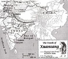
Route Map of Xuanzang's "Journey to The West" (India).
a thriving City, a center of commerce, an important administrative center and military strongpoint, and a market city for international trade. Here, at roughly halfway the length of the Hexi Corridor was where many traders from Central Asia traveled to pick up wares at the local Market, bundle them up and carry them back to the West by Caravan.
Although after the Fall of the Han Dynasty the Rule of these territories temporarily reverted to the leaders of native local Population, Zhangye would be conquered again and included in the Empire of the Northern Qi Dynasty (a part of the so called Six Dynasty Period 420 AD - 589 AD).
For centuries it a stop-over on the busy and once more flourishing Silk Road of the Tang Dynasty (618 AD - 907 AD) and, overtime, it was included as a integral part of the Chinese Nation. A renowned traveler from this Era, known as the Monk Xuan Zang traveled from the Capital of China
at Chang'An (Xi'An) through Zhangye to reach the Yumen - Jade Gate at Dunhuang where he managed to slip out of the Empire on his way to India, homeland of Sakayamuni Buddha. He returned to a Heroes welcome and is largely credited with the spread of Buddhism in China during the Tang Dynasty (618 AD - 907 AD).
Although the Mongols descended upon the Continent and established the Yuan Dynasty to Rule the Cathay Khanate (China) they adopted Chinese Features and left the town of Zhangye untouched. It was during this period, in the second half of the 13Th Century when Marco Polo reached the town from the Silk Road pathways in the West. Since Marco Polo stayed for a long period, around a year, he had ample time to get acquainted with the Town, the region, the monuments and its people. However, sadly, Marco Polo wrote far less than one might have expected. The few things Marco Polo did mention led to many questions in the West, since in his writings he had reported a community of Christians in these remote far Eastern Regions. Soon other
Westerners would follow in an attempt to find out some answers.
The later revival of Chinese Power during the early Ming Dynasty in which the Silk Road as well as the Great Wall defenses nearby played an important role in National Finance and Pride, left some distinct architecture specific for that era. Zhangye remained steadily inside the Chinese Empire throughout most of the following Centuries, although at the end of the Qing Dynasty (1368 AD - 1644 AD various Islamic Uprisings occurred. Thus, even today a visit to Zhangye is a visit to a distinctly Chinese City with according architecture and features, regardless of its multitude of ethnic peoples.
For the Complete History of Zhangye City & Prefecture, click through to the History of Zhangye Page.
As described in the main introduction to Gansu Province it was thus of strategic historic importance over the last 2000 years, the Era of the land-bound Silk Road.
In the history of this famous Silk Road Zhangye city is of special significance for two reasons: first of all it was historically the first part of the Silk Road trajectory that was subjected during the early Han Dynasty Era (206 BC - 221 AD). Thus, Zhangye was the founding stone upon which later Military achievements were built.
This fact is still reflected in the name of the city today, as Zhangye literally means "extending the arm". This term Zhangye in turn is an abbreviation of the statement; "to extend the arm of the country, through to the Western Realm" (张国臂掖,以通西域). Another more vicious translation coined is "Cutting away the Arms of Huns, and extending the Glory of The Empire". This is a semi-modern term and name for the town however. The original name chosen by the Han once the region and town were subjected militarily and included into the Chinese Empire was Ganzhou (甘州). Thus, the later Han Dynasty Province which was founded upon the cornerstone of Zhangye was named GANsu, which remains the name of the Province today.
Furthermore, even today the City of Zhangye is known to the Provincial and National Administration as Ganzou District. For all practicalities however, most people use Zhangye to designate the Capital Town today.
During the Han Dynasty Reign Zhangye became an important administrative base from which various military and diplomatic operations embarked. From here, emmissaries of the Han King embarked on their dangerous travels to the West, first to explore these regions, then to forge aliances with various tribes, in order to later and finally overpower them. This was the very process that forged the earliest Silk Road path. Zhangye of the Time was the political, economic and cultural center of the remore North-Western Province of the growing Empire. As the Han successes followed upon eachother, over time Zhangye slowly grew into a major administrative City and stop-over on the Silk Road pathway into Chang'An (Xi'An), the National Capital. It retained this function for the full time the Silk Road was in operations, which was well into the 16Th Century.
Reflecting this important function as the Capital of the North-West, many famous figures in Silk Road history passed through Town. Among these Imperial Envoy Zhang Qian - credited with the first opening of a western route, general Ban Chao-credited with defeating the Xiong-Nu (Western Mongolian) Tribes, Buddhist monks Fa Xian and Xuan Zang, the latter credited with bringing buddhist knowledge to China during the Tang Dynasty, and many others. Chinese and Non-Chinese. (Chinese: 额济纳河 Ejina-he, Mongolian: Etsin-gol, Edzin-gol), also known as the Heihe River (黑河, lit. "black river"), is a major river system that originates on the northern Gansu side of the Qilian Shan mountains.
The Ejin River , also known as the Heihe River , is a major river system that originates on the northern side of the Qilian Shan mountains in Gansu Province. The river is around 800 km long two major branches: the western branch flows from Zhangye through Gaotai and well North of Jiuquan, while the eastern branch flows through Ganzhou. The two branches merge near Gaotai Town and flows north into the Inner Mongolia Autonomous Region, where the river terminates in the Ejin Basin in the Gobi Desert just South of the border with the Republic of Mongolia.