Qinghai Province is a Chinese Province with a unique history as it was only absorbed into The Peoples Republic of China in 1959 AD. Until 1950 AD, when a Chinese Military campaign into East Tibet took place, Qinghai Province did not exist other than as an inseperable part of the Tibetan Region and The Nation of Tibet.
Ethnic Minority Groups of Qinghai Province :
Among things due to its geographic position along main crossroads of Civilizations the Province of Qinghai is home to a variety of ethnic groups. Some derive their history from the Central Asian Steppes and the wars and great human tracks along the ancient Silk Road, others find their origins upon the Tibetan Plateaux of which Qinghai Province is but a lesser part. All minority groups prsent have all been living in Qinghai for many generations.
According to the offcial Chinese Government Census Qinghai Province is currently home to 55 ethnic groups, which means that all but two of the 57 Chinese ethnic groups in China are supposedly represented. This is however practically untrue and somewhat confusing or misleading.
Today Ethic minorities make up more than 2.38 million, or 45.5 percent of the total population of Qinghai Province. Of them the far majority are Tibetan, Hui, Tu, Salar and Mongolian. The Tibetan people account for 21.89 percent of the province’s population, the islamic Hui 15.89 percent, Tu 3.85 percent, Salar 1.85 percent, and Mongolian 1.71 percent. The remainder are Han imigrants of whom more and more are entering Qinghai Province.
Main minority groups in Qinghai Province are the Tibetans, the Mongolians and The islamic Kazakhs, but there are a number of other smaller minority groups in the Province, all with their own destinct cultures, dress, festivals and religious beliefs. These smaller groups are the Yugur, the Salar (Sala) and the Tu People.
Qinghai is mainly known for its Tibetan Population as it is roughly encompasses the Eastern Half of (former) Tibet.
Among the ethnic groups near uniquely found in Qinghai Province are the Salar ethnicity. This small but distinct islamic ethnic group mainly reside inside the Xunhua Salar Autonomous County in the extreme East of Qinghai Province. Other Salar reside in their communities in Hualong Autonomous County of the Hui Nationality within Qinghai Province, and nearby in bordering Gansu Province in Jishishan Autonomous County.
TheAveragealtitudeinQinghaiis3000meters(9600feet), thus verygenerallyspeakingQinghai Province has acontinentalhighplateauxclimate.
The climate on the Tibetan Plateaux various remarkable from location to location but in general is characterized by short cool summers and long freezing winters.
Qinghai is known for its dry mountain winds and cold weather. The annual mean temperature is -5° °C to + 8°C and the annual precipitation is around for all of Qinghai is 250 to 550 mm. As should be expected from a high mountainous plateaux the precipitation however varies significantly between regions. The southeast area receives more rain than other area's of Qinghai with 450-600 ml of rainfalls annually.
Due to drastic temperature fluctuations from day to night throughout the year, the summer period is the best time to visit Qinghai. Not only are various minority Festivals held in this period, in summer roads are open making it possible to travel to the remotest corners of the Territory. In winter the road to Golmud is often closed and the Tanggula Pass which connects into Tibet Autonomous Region and through to Lhasa suffers from high winds and abundant snows.
During the hot summer monthswhenmostofthecoastalregionisbakinginunbearableheat, many tourists from the Southern and Eastern parts of China travel to QinghaiProvince, as the climate of Xining in July and August is quite mild and comfortable, making the city an ideal summer retreat.Itisbecomingthenewtouristhighseason.
Climate in Qinghai Province :
Main Pillars of the economy today are miningandpetro-chemicalindustries.Qinghaiisespeciallyrichinmineralswho'sdepositsareincreasinglyexploited.Minerals foundinabundanceincludeKainite,asbestos, glauber's salt, silica and boron. Especially boron is found in no higher quantity than in Qinghai Province.
Qinghai Province is also surprisingly rich in Oil, Petrolandnaturalgasreserves.TheQaidamBasinintheNorth-WestisthecenterofOilandGasIndustryaswellasthesceneoffranticminingactivity.
Map China Ethno-Linguistic / Language Distribution China
InsurfaceareaQinghai is byfarthe largest of China's Provinces. It is located in the Western parts of the Nation. Roughly speaking it makes up the north-eastern half of the famed region of Tibet (which existed in independence from at least 1913 until the 1950's).
Qinghai Province measures some 1.200 kilometers from east to west and 800 kilometers from North to South. The average altitude in Qinghai Province is 3000 meters but peaks reach far higher to 6500 meters and sometimes beyond. Thus, around 54% of the Province lies at altitudes between 4,000 and 5,000 meters. Main Mountains of the Province are Mount Tanggula with a height of 6205 meters in the extreme southwest of the province, Mount Arjin and Mount Kunlun. Less famous but equally impressive are the Buka Daban measuring 6860 meters and located in the far west in a barren zone on the border with Xinjiang-Uyghur Autonomous Region, Altun Shan (5798 meters) on the border with Gansu Province south of Dunhuang and Aksay Kazakh Autonomous Township, and last three peaks of the Bayan Har Mountains bordering on Sichuan Province, Dalongsai Peak (Height 5496 Meters), Bayan Har Shan (Height 5266 Meters) and Nyaindo Yuze Shan (Height 5369 Meters).
The Topography of Qinghai Province Autonomous Region can generally be divided into three distinct and very different zones. These are the East, the North-West and the South-West.
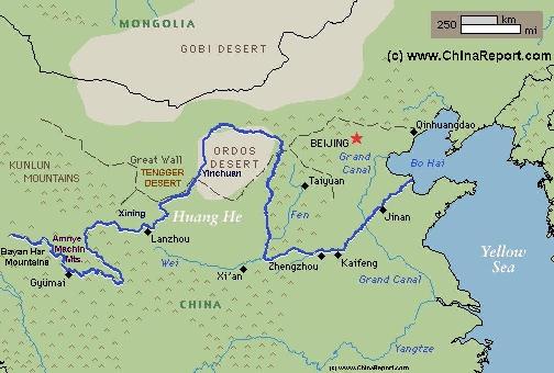
The most hospitable regions for human inhabitation can be found in the East of Qinghai Province around the Capital City of Xining and the giant Qinghai Lake. Naturally, this is where most of the population of Qinghai Province resides. The entire Eastern Region of Qinghai is made up of grassy highlands which are nevertheless intersected by ranges high mountains. The Highland zones lie at altitudes between 2500 and 3000 meters, however the surrounding mountains rise up to 5000 meters and slightly more. The Southern Zone of East Qinghai Province is especially rugged. There, wedged between the Amnye Machin Mountains and peak, and the even higher Bayan Har Mountains in the South lies the source of the Yellow River (Huanghe), China's second largest river. The Bayan Har Mountains form a natural border with Sichuan Province to the South, and to a lesser extend the South-Qinghai Basin in the South-West.
In the North and North-West landscapes are surprisingly different consisting mainly of high altitude deserts interspersed with salt lakes and high peaks. The center of the North-West is the very large Qaidam Basin in the middle of which sits the largest population center of the region, the City of Golmud. It is a barren region which suffers especially from high winds and harsh cold snow-blown winters.There are few roads, many salty marshes and bogs but few pasture-lands.
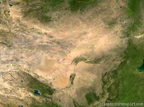
Map of the Gobi Desert & Yellow River Flow
Satellite Image Map of the Gobi Desert Region. Map overviews North-West Xinjiang Autonomous Region, Mongolia, Inner Mongolia and North and North-Eastern China giving a Full Overview of the Gobi Deserts and Yellow River Basin. Map includes country borders, name + location of Cities and Villages (clearly visible).
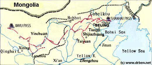
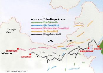
China Report - Map of the Great Wall during the Ming Dynasty
Satellite image of China and North-East Asia, with a super-imposed schematic Map of the location and Path of the Great Wall as constructed during the Reign of the Ming Dynasty. Included for reference are City names, geographical features of landscape, Names and locations of Passes on the Great Wall of China.
Capital of Qinghai Province - Xining
Surface Area / Size -721.000 square kilometers (278,000 sq. miles)
Population - 5 Million 390.000 (2004). Natural growth rate of the population +9.87‰.
Map Great Wall China - Layers of Dynasties and Era's
A Schematic Map of China and East-Asia, with a super-imposed schematic of the various layers of the Great Wall of China.
Features Pre-Qin Dynasty Wall, Qin Dynasty Wall, Western Han Great Wall of China, the (Northern) Jin Dynasty Great Wall and finally the Ming Dynasty Great Wall as mainly remains today.
Main Features are Names and locations location of Passes on the Great Wall of China, outer layer and inner layer. Includes Shanhai Pass, Huangya Guan (Yellow Cliff) Pass, JiYunGuan Pass, Ningwu Guan Pass, Pingxin Guan, YaMen Guan Pass, Pian Guan Pass, JiaYuGuan pass, YuMen Guan Pass (Jade Gate) and Yang Guan Pass.
Further included for reference are City names, geographical features of landscape and main mountain ranges. Updates occur several times a year adding new pass locations and photo-virtual tours of Passes throughout China.
A Schematic Map of Historical Tibet, today Tibet Autonomous Region, Qinghai Province and a part of Sichuan province.
Included for reference are current International Borders, provincial borders, locations and names of main cities and towns, main rivers and lakes, mountains,importantTibetan-BuddhistMonasteries and other places of significance.
Further Reports link to More Photos and History & Backgrounds of each City, Town or Ethnic Community of Yugur, Dongxiang Tibetan, Lhoba, Kazakh, Mongol or others where available.
Today Tibet only exists as Tibet Autonomous Region of China. Tourist visits require an aditional visa !
Huang-
Ren
HaiBei
Hai-
Dong
Hainan
Golmud
Golog
Yushu
Baima
Mts
Shan
Tangula
Wenquan
Serxu
Yushu
Madoi
Main Rivers and Waterways of Qinghai Province :
The Main Rivers in Qinghai are the Yangtze River and the Yellow River (Huanghe He), which both spring from regions in the South of the Province. Others are the Shule River, Datong River, the Buh River, the Qagan Us River, Urt Moron River, Narin River, Togton River, Tongtian River, the Dam Qu (River), Zha Qu, Ji Qu River and finally the Qu River itself.
In the south notable main rivers include the Yellow River and the Lancang, Jinsha and Yalong Rivers which all spring from roughly the same region near Yushu Tibetan
Autonomous County. Thus Yushu is also known among the native Tibetans as the 'Source of Rivers'. Many minor rivers and streams cut through the mountainous Province.
Main Cities & Population Centres of Qinghai Province :
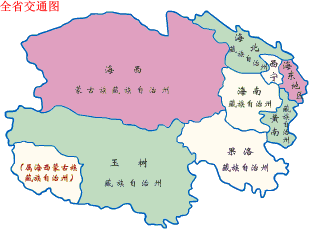
Xining (西宁市), Golmud -Ge'ermu or Geermu (格尔木), Haiyan in Haibei Tibetan Autonomous Prefecture (海北藏族自治州), Ping'An in Haidong Tibetan Autonomous Prefecture (海东地区), Gonghe in Hainan Tibetan Autonomous Prefecture (海南藏族自治州), Tongren in Huangnan Tibetan Autonomous Prefecture (黄南藏族自治州), Delingha in Haixi Mongol & Tibetan Autonomous Prefecture (海西蒙古族藏族自治州), Yushu (Gyêgu) in Yushu Tibetan Autonomous Prefecture (玉树藏族自治州) , Maqen in Golog Tibetan Autonomous Prefecture (果洛藏族自治州).
Qinghai Province is divided into 1 City Prefecture - Xining, 1 Prefecture - Haidong and 6 Ethnic States (Autonomous Prefectures). Such Prefectures are further subdivided into Counties.
Transportation & Travel Connections in Qinghai Province :
RAILROADS IN QINGHAI:
Currently the most important railroad in Qinghai Province is the now internationally famous Tibet Express, in China known as the Xizang or Qinzang Railway. This railway connects the Capital of China,Beijing,withLhasa, CapitalofTibet(AR).Intotaltheentirerailroadmeasures1956 kilometers (1215 miles),alargeandratherwildsection of which lies within Qinghai Province.Infact,therailroadconnectsthroughLanzhoutoXiningandfromtherewestwardtoDaQaidamfromwhereitdescendstoGolmudandfurtheracrosstheTanggulaMountainsanddownintoTibetAutonomousRegion.
The railroad between Xining in East Qinghai and the Golmud in West Qinghai was the first section that was added to the existing railroad network in China. This 815 kilometer (506 miles) long line was completed by 1984 AD.
After further preperations construction was started on an even more challenging line, connecting from Golmud across the 6000+ meter high Tanggula Mountains into Tibet Autonomous Region and the end station at Lhasa. Conditions in this region are difficult most times of the year. In addition the Tangula Pass included in the Xining to Lhasa railway line reaches a staggering 5,072 meters (16,640 feet) above sea-level making it a formidable obstacle for any combustion engine. The Tanggula railway station (located at 5,068 meters) is the highest station in the world and already an extreme tourist destination.
Regardless, technical obstacles were surmounted and the 1142 kilometer (709 mile) section between Golmud and Lhasa was inaugurated on 1 July 2006 by president Hu Jintao to much national applause. Eversince a journey on the railway line has become one of the Great Railroad Experiences of the world.
Apart from the highest railroad mountain passing in the world at Tangula Pass, the railroad includes spectacular tunnels such as the 1,338 meter long Fenghuoshan tunnel which today is counted as is the highest rail tunnel in the world at 4,905 meters above sea level. The spectacular Guanjiao tunnel on the railway line from Xining to Golmud with its 4,010 meter length is the longest railway tunnel in Qinghai Province (and China) and the railroad section from Golmud down to Lhasa includes another lenghty tunnel, the 3,345-meter long Yangbajing tunnel.
According to the Chinese Railways more than 960 kilometers, or over 80% of the Golmud-Lhasa section, lies at an altitude 4,000 meters or more. There are 675 bridges on the Qingzang Railroad in Qinghai Province and Tibet Autonomous Region, totalling together 159.88 kilometers of railway.
Another notable fact is that some 550 kilometers of the railway are laid on permafrost, which means supposedly permanently frosen but otherwise boggy grounds. So far this has not caused major disruptions of the Line.
As noted historically the first and foremost Route into Qinghai Province is through the City of Lanzhou in Gansu Province which has both a strategic and historical connection with the Capital of Qinghai, Xining.
Until some twenty years ago road connections in Qinghai were nothing like they are today. Roads were sparse, narrow and often cut or threatened by rockfalls, flash floodings and winter snows. Today roads in Qinghai are still sparse. Officially the total length of operational roads and highways in the Province total 17,200 kilometers and rising. The traditional main route into Qinghai Province leads through Lanzhou, the Capital of neighboring Gansu Province which lies at a relatively short distance. This is the Highway G109 or Lanzhou-Xining Expressway. Lanxi for short.
From Xining the highway transport network radiates to all parts of the province.
AIRPORTS IN QINGHAI:
TherearecurrentlythreeairportsavailableinQinghaiProvince.The main airport in Qinghai ProvinceisXiningCaojiabuNationalAirport.QinghaiProvince has directflightconnections
A Full and complete Map of China (PRC) identifying all Language Areas big and small in all Provinces and Autonomous Regions of China.
Map includes Turkic Languages (Uygur, Kazakh, Kirghiz, Salar & Uzbek), Mongolian Language and Sub-Divisions (Mongol, Tu, Daur and Dongxian), Tungusic Peoples (Oroqen, Evenki and Xibe) and Languages, Korean, Tajik (Tadzhik), Mon-Khmer (Kawa + Puman (or Pulang)), Hui, Uygur (Uighur), Tibeto-Bhurman Languages, Tai and Miao, Yao and She' Language Area's and Borders. Main Area's and sub-divisions of Han Languages (Northern Mandarin, Eastern Mandarin, South-Western Mandarin and Cantonese) further included. This color-coded ethno-linguistic Map (of 1967 AD) identifies at a glance most ethnic minority regions in China
The third topographical zone in Qinghai Province is the South-West which consist of a high-altitude plateaux which sits at an average altitude of some 3500 meters (14.000 feet). In the South this part of Qinghai Province is separated from Tibet Autonomous Region (i.e. the rest of Tibet) by the impressive Tanggula Mountains (Tangula orDangla Shan), a mountain range with peaks of 6500 meters. China's largest river, the Yangtze (Jiang) originates from this part of Qinghai Province and its source can be found in the western sections of the Tanggula Mountains just North of the 6205 meter heigh Tanggula Peak. Another important river, the Mekong River which
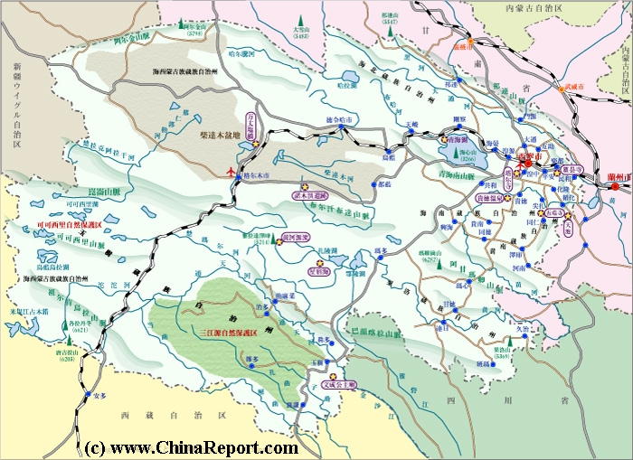
Geographical overview of Qinghai Province(EastTibet)inWest-Chinawiththemainregions,populationcenters,lakes, landmarks, monumentsandscenicsights.
supplies most of the South-East Asian mainland (Vietnam, Laos, Cambodia) originates in the Eastern Tanggula Mountains as the Lancang River (Lancang Jiang). Several other main rivers, such as the Yalong River and Jinsha River, originate in this region as well. Eventually all of these rivers flow across the border and southward into Sichuan Province.
Most of this southern region of Qinghai consist of grassy lands and although there are few towns and villages, the region is fairly well populated. Even today the population of south Qinghai Province consist of semi-nomadic herders raising goats, sheep and yak. They are mainly minority people; Tibetans, Tu, Yugur and Kazakhs. The Han immigrants into the region are mainly settled in- and near Xining.
Qinghai Province is named after the Qinghai Lake (also known by it's Mongolian name as Kuku Nor), is the largest inland fresh-water lake in China. The Qinghai lake covers some 4340 Square Kilometers and with its unique wildlife and varied landscapes and sceneries is regarded as one the Jewels of the Province.
Today, Qinghai Province ranks among the poorest provinces in China and is a region with an exceptionally high unemployment rate. Although for years the Central Government has invested massively in infra-structure projects the situation has only been marginally improved. Most economic activity takes place in the Eastern regions of the Province in- and around the Capital Xining. The City of Golmud in the West is another economic hotspot.
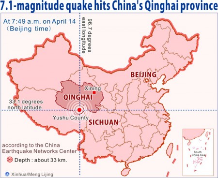
Qinghai Province, as is the wider region is susceptible to heavy earthquakes. The latest earthquake struck in April of 2010 devastating the Southern Basin centering on the Town of Yuchu (Yuechi or Tibetan: Gyêgu).
Qinghai falls under the responsibilities of the Lanzhou Military Command and Region.
There are but 16 museums in Qinghai Province. The Top Tourist attractions of Qinghai Province are considered to be the the Ta'Er (kumbum) Monastery, The Dongguan Great Mosque of Xining first built in 1379 AD, the Giant Qinghai Lake which lies only 100 kilometers west of Xining, and the the natural sceneries of the Province among which first and foremost the Mengda Nature Reserve. Next in popularity are the various minority communities near Xining and in South Qinghai Province. There are however many more smaller worthwhile things to see and places to visit.
Much less talked about let alone highlighted or visited are the remnants of The Great Wall of China in Qinghai Province.
Yes, that is correct: sections of the Great Wall of China are found in the Eastern-most parts of Tibet as well, where it functioned to prevent a complicated military bypass of the main Chinese Defenses along the Northern Hexi Corridor (in nearby Gansu Province), as well as the demarcation of the border with non-Han Tribes, in effect the border of China. Not much discussed by Chinese Tour-agencies nor published on in popular tour-guides, West of this (lesser) part of the Great Wall lay the territory of the Tibetans, for centuries ruled by the Lama's of the Yellow Hat sect of Tibetan Buddhism. Although Xining functioned as a major
Schematic Map depicting the multiple layers of the Great Wall of circling Beijing and North and North-East China.
Chinese Military strongpoint since the 16Th Century, the main defenses of entire West China centered on the City of Lanzhou more to the East on the Yellow River.
Apart from this issue as a background, Qinghai Province has a rich and long history in connection with the Han Peoples and other peoples of the Region through the Silk Road and other trading paths of the wider region. Contacts ran South to Burma and India, as well as Westward with the many nomadic Peoples of Central Asia. First contacts with the Han were established very early during the Warring States Period but were further developed after the rise of China during the Chi'In Dynasty (221 BC - 206 BC) and succeeding Han Dynasty (206 BC - 221 AD).
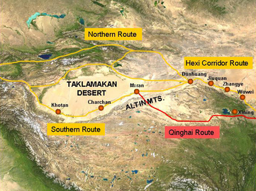
The main pathway of the Silk Road, established around 100 BC and developed thereafter, led westward out of Chang'An (Xi'An), across the Yellow River at Lanzhou, to travel around the Tibetan Plateaux and the current Province of Qinghai through the Hexi Mountain Corridor to the West. A minor secondary route out of Lanzhou passed however through Xining and across the Northern Edge of the Tibetan Plateux to rejoin the main path at the lost City of Miran which was only refound by Aurel Stein in the early 20Th Century.
This ancient route still exist today Century as a minor provincial road through barren regions.
Schematic depiction of the main pathways o/t silk road passing along the north-rim of the Giant Tibetan Plateaux and the secondary path bypassing the Hexi Corridor through Xining.
'Qinghai' , is best understood as a Province when viewing a 3D Relief Map of the entire region of Tibet making up the vast proportion of the lower lying regions of the Tibet Region with the largest populations. in the Past these regions were identified as the Tibetan Provinces of Amdo and Kham(do).
'Qinghai' then was first created as Qinghai in the 1920's and became a province under the second Republic of China in 1928 AD, after Chiang Kai-Shek took power over the Kuomintang 'National' Party.
Subsequently parts of it fell under control of the so-called Five Ma's or the Ma Clique of Warlords.
The Tibetans regarded it as a part of independent Tibet. This was the situation until one of the earlier decisions of the establishing Government of the Peoples Republic of China once more named Qinghai as a Province of China. From this and other issues, a conflict arose with the then functional and nominal Government of Tibet located in Lhasa.
SatelliteImageofChinaandotherpartsofAsiaatnight,clearlyshowingtheTibetanPlateuxasablackgap. Since population has grown, population centers grown and connected to electric power-grids. Regarless many parts of Qinghai Province are virtually uninhabitable.
The second route into Qinghai Province leads from Chengdu City to the West, then North-West into North-Western Sichuan Province. This route keeps south of the Bayan Har Mountains with create a natural border with Sichuan and passes through the Towns of Garze and Serxu (both with large Tibetan Minorities) across the Provincial Border into the South Qinghai Basin. The first leg of the route past Garze is made up National Road G317, but after reaching Manigange Village (Xiang) one turns onto Provincial Road S217, a narrow winding path. Once within Qinghai Province, the S217 conects to road S307, then not much later to National Highway G214 connecting to Yushu, the main population center in this area, and its Airport.
The third route was the last established. This is the G109 National Road which passes from Lhasa in Tibet (Autonomous Region) northward to Nagqu, and from there to Amdo and through the Tangula Mountains into Qinghai. After crossing the Tangula Mountain pass the road winds it way between the mountains and past several villages before reaching Golmud. The Road connection to travel Eastward to Xining lies further North at Da Qaidam, near the border with Gansu Province.
As noted historically the first and foremost Route into Qinghai Province is through the City of Lanzhou in Gansu Province which has both a strategic and historical connection with the Capital of Qinghai, Xining.
Ratedasone of the five mainpasturelands in China, Qinghai Provincehas 36.46 hectares of pastureland, accounting for 50.54 percent of the province’s total area.
FacilitatedbynowthreeairportsintheProvincethetourismindustryfocussesontraditionallyonXining,andcurrentlymoreandmoreontheminoritycommunitiesinNorth-EastandSouthQinghai.AfewyearsagoYushuairportwasthethirdairporttobeopened,connectingvisitorsdirectlyfromXiningtotheYushu (Gyêgu) Tibetan Autonomous Prefecture (玉树藏族自治州).Theopeningofthe1180kilometerlongQinghai-TibetanRailway(or Xinzang Railway) had opened an entirely new chapter in the economic development of Qinghai Province and the Tibet Region.
TibetandTibetansarefashionableifnot'Hot'inChinaandeveryyearmoremiddle-classvisitorsfromChina'slargecitiescome and have a brief and superficial encounter with the Tibetan Culture (as it is presented by main stream Tourism industry).
The traditional specialities for which Qinghai is well-known within China itself are mainly marmot skin, various styles of carpetry, lambskin, and handicraft articles such as silver ware, ornaments and Zang-style knives. In the past, the Tibetan Antilope, considered as the main mascot of Eastern Tibet, was hunted for its skin. Up to as recently as the 1980's and 90's they were in danger of becoming extinct due to the fact that shawls made of Tibetan Antilope hair could fetch high prices of tens of thousands of dollars on the International Market.
Since the year 2003 a complete ban on hunting the Tibetan Antilope is enforced, resulting in a reversal of fortune for the animals. Today they are well over 50.000 in number.
XINING CITY:
The City of Xining is the largest City in Qinghai Province and traditionally the focal point of Han influence in Eastern Tibet (now Qinghai Province). Today it is well connected City served by both the Tibet (Qinzang) Railroad and the Xining Caojiaba Airport. More and more foreign travelers pass through Xining.
Although the City counts well over 1 million citizens Xining is a fairly unremarkable place. There are but a few historic monuments in Town and entertainment is not abundant. On the other hand there are many markets providing for a vibrant streetlife in Town. The largest of these markets is the Shujing Xiang Market found near the West Gate (Xi Men).
The main historic landmarks of the City are but Three. These are the Great Mosque of Xining, the Beishan Si or North Mountain Temple and the various markets which reflects the customs cultures and needs of the Local People, many of whom are of minority origins.
The Great Mosque of Xining was founded in the early years of the Ming Dynasty Era (1368 AD - 1644 AD) , after the defeat of Yuan Dynasty or Mongol loyalist armies in the region in the aftermath of the fall of the Mongol Yuan Dynasty (1271 AD - 1386 AD) in China. The original Mosque was constructed on Han Chinese orders as as a gesture of appeasement from the Han to the Muslim Tribes of this specific region. With their allegiance sorted, these ethnic groups were officially included within China and allowed to stay and graze their herdes on the mountain slopes of Qinghai and along the Hexi Corridor of Gansu Province, just inside the protection of the Great Wall of China. In the centuries that followed they settled in these remote regions, keeping much of their own culture and identity. Their descendants can still be found living in the mountainous regions surrounding the Capital of Xining.
Beishan Si is of far lesser historic significance and is mainly known for the excellent view of the City to be had from the North Mountain.
XINING REGION:
There are three main scenic sights in East Qinghai Province. Two of these lie relatively close to the provincial Capital of Xining with its airport, the third -Mengda Nature Reserve-lies at considerable distance and travel time away from Xining and is far more difficult to include into a travel itenerary.
The closest historic and cultural destination to Xining is the Kumbum Monastery, known in Chinese as Ta'Er Si. The Kumbum Monastery is important and interesting for many varied reasons but mainly because of its religious function as the second of the six important Monasteries of the dominant Yellow Hat Sect of Tibetan Buddhism-Lamaism. In history the Kumbum Monastery was second in importance the Drepung Monastery in Lhasa (Tibet AR), which was for a long time the center of religious power in the Nation. The key of the Holy Status of the Monastery lie in its historic origins as it was built on the site of the Birthplace of the main inspiring figure of the Yellow Hat Sect, Tsongkapa. According to legend, Tsongkapa was born in 1357 AD under a Tree that stood on this location. Only a few years later the mother of Tsongkapa and some locals established a stupa in comemmoration of the birth, providing a first recognizable buddhist prayer site. In 1583 AD the Monastery itself was established, after which the complex grew into one of the main bastion of this particular line of thought. The Main Shrine Hall of the Monastery is a golden roofed Hall known as the 'Golden Tiled Temple' throughout Tibet and Mongolia, which was supposedly built around the original Tsongkapa Birth-place Tree, since known as the 'Tree of Merit'.
Today Kumbum Monastery is the main tourist attraction in East Qinghai Province, located at only 26 kilometers from the City near the village of Huangzhong. In 1990 AD the monastery was nearly destroyed in an earthquake and the following heavy snows of an unusually harsh winter, damaging many of its buildings, however in the aftermath the Provincial Government provided funds for a nearly complete restauration of the entire complex. Eversince the Monastery with its unique Tibetan athmosphere has grown each year in popularity. Visitors to the Monastery are allowed to view 6 main Temple Halls of the Complex, but certainly not all of the buildings and halls. A great experience is the scenic clockwise around hiking Tour around the monastery guided by Buddhist Monks.
Although no photography is allowed inside all Temple Halls, there is plenty to witness, see and photograph on each and every visit.
The second scenic site to be found in the vicinity of Xining is Tso Ngon or Lake Qinghai in Chinese terms, the largest inland lake in China. The eastern shore of the Lake lies at only a 100 kilometers distance from the City making it a viable destination for a worthwhile daytrip.
The Fifth popular scenic location to be visited in the 'vicinity' of Xining is the Mengda Nature Reserve. This destination lies at some 190 kilometers from Xining. A proper visit requires a long day-trip and possibly a stay-over for an in-depth experience.
The main attractions of the Park are found not only in the natural scenery surrounding the Tian Chi - 'Heavenly Lake' but equally in the presence of the Sala, or the Salar Minority Peoples as well as the nearby flow of the Yellow River (Huang He). In fact the route to Mengda Nature Reserve leads along the gorges of the Yellow River and other spectacular sights.
The Lake Tian Chi is a native home of the Sala who revere it as their God, and is considered equally by local Tibetan Buddhists.
Travel comfortably from Xining to Xunhua from where the journey continues for 1 and a half more hours to the Town of Huang He (not to be mistaken with Huanghe in Central Qinghai near Madoi, known as the source of the Yellow River) by Bus or Car. The Bus stop is at the Town of Huanghe from where it is another 4 kilometers walking to the Gate and Ticket Office. Travel the length on foot or succumb to the persistent offers for riding animals from the local peasantry.
Once inside the gate there is yet another exhausting but spectacular one hour hour hike up to the Lake. Once at the Lake one can enjoy a rest at the Lake Shore or walk around the Lake, climbing peaks overviewing it in turn.
After an exhausting hike one can return to Huang He Town to get a taste of Sala Culture, however the village should be counted as an attraction by itself. Those who, not surpisingly cannot muster the energy can stay over and explore the village another day.
Noteably, busses pass through Huang He village on the way to Dajehe Town, from where a connection can be made to Linxia , an autonomous Hui enclave and Garrison Town just across the border in Gansu Province and only a short hop from Lanzhou, the largest City in Western China.
The sixth last but certainly not least important scenic site and historical monument in Qinghai should be considered the Great Wall of China built along the eastern rim of the Tibetan Plateaux. These sections, not much published on and apparently unvisited today were originally constructed during the Ming Dynasty, when a The Great Wall of China reached it highest state of development.
Although the main defenses of this very large region faced Northward and Westward and were formed by the main outer line of the Great Wall which runs North of Lanzhou and along the northern edge of the Hexi Corridor, additional sections were built west of Lanzhou and East of Xining, mainly in order to prevent an out-flanking maneuver of the Main Defense Line and Force. There was however also a deeper hidden motive behind its construction. Although at the Time of the early Ming Dynasty (1368 AD - 1644 AD) the Tibetans had accepted allegiance to the Chinese Imperial Throne in Beijing and posed no threat, earlier during the advance of the Mongol Armies on China preceding 1271 AD and the establishment of the Yuan Dynasty the Tibetans had been close to signing allegiance with Genghis Khan and his now infamous Mongols against the Han Chinese. Thus, the Wall also served as a back-up just in case the Tibetans would change their minds later and turn upon their nominal masters.
Thus, the Great Wall of China in Qinghai Province is not part of the main defensive line that has been so hailed by many throughout the centuries. The Wall, of which remains are located somewhere between Xining and Lanzhou should be regarded as only of secondary importance, perhaps this is one reason why it goes nearly unmentioned today.
Schematic overview Map of Qinghai Province depicting main roads and rail-connections, main mountains and rivers, plus landmarks and locations of interest.
species can be found and hopefully seen in relative abundance. The most famous viewing spot and breeding colony is Niao Dao or Bird watching island, which lies on the Western Shore of the lake at a far greater distance to the City, some 300 kilometers.
Not in the list of tourist magnets but certainly worth a mention is the flow of the Yellow River through Qinghai Province. Although the source of the Yellow River, China's second largest, lies amid rough terrain in central Qinghai Province far from Xining the flow of the mighty and famous river can be reached from Xining. In fact. A visit to the Yellow River could combine well with a hike into Mengda Nature Reserve and a visit to its Heavenly Lake.
Apart from these main well-known and popular places to visit in Eastern Qinghai province in the Region of Xining there are a small number of other historic and interesting monuments which should be noted. Due South of Xining these are the Bainqen memorial Pagoda of Gonghe, the Hejin Mosque and the ethnic enclave Town of Guide, The Town Mosque of Hualong Town, The Kanbula Forest north of Jianca, the Longwu Temple south of Jianca, the Xihai Lake and the Wutun Temple of Tongren City.
West of Xining in Ping'An travelers can visit the Qutan Temple which is also known as the 'Small Imperial Palace in Qinghai'.
North of Xining are yet more sites and ethnic enclaves. The Northern Regions are the home of the Kazakhe, the Tu, The Yugur and the Dongxiang. Monumental sites include various temples and mosque reflecting the faith of the local ethnic group. These are in order of estimated distance to Xining the Youning Temple, the Guanghui Temple, The Haomen Mosque west of Menyuan Autonomous Township, the Baihu Temple outside Muri and finally the Gaggao Temple due north-west of Ganca Village.
Last but not least are the wild and adventurous destinations of the snow-capped A’Nyemaqen Mountain, overlooking the source of the Yellow River, Sun-and-Moon Hill, and Longyang Gorge Reservoir of the Yellow River
China Report - Schematic Map of the Yellow River Flow Path 01A
A Full Schematic Map of the entire flow path of the Yellow River. Map overviews Qinghai Province, Parts of Sichuan Province, Gansu Province, Ningxia Hui Autonomous Region, parts of the Republic of Mongolia, Inner Mongolia Autonomous Region, Shaanxi Province, Shanxi Province, Henan Province and finally Shandong Province, giving a Full Overview of the length of the Yellow River. Clearly visible details of geographical features such as mountain ranges, rivers, valleys and lakes. The Map includes main cities along the River, popular and famous scenic spots, the dams and water reservoirs on the Huang He and other relevant informations.
Click the links to find more information on each individual location !
According to the Year 2000 National Census there were 104.500 Salar in China (P.R.C.) of whom most in Xunhua County.
The Tu are an ethnic minority that lives primary along the Huang and Datong rivers in the Huzhu Tu Autonomous County in northeast Qinghai Province. The rest are scattered mostly in the eastern part of Qinghai Province. The Tu are similar ethnically to the Muslim Dongxiang and Bonan. What sets the Tu apart is that they are Buddhists. They regard themselves as Mongolians or White Mongols and what sets them apart from the Mongolians and Mongols is that have intermarried more with Chinese and live in an area traditionally occupied by non-Mongolians.
The Tu are also known as the Huzhu, Guanting, Mongols, Monguor, and White Mongols. A 1990 census counted 192,000 of them. They speak an Altaic language similar to Mongolian and have no written language of their own (they use Chinese characters for writing). Most belong to the Yellow Hat sect of Tibetan Buddhism. Families have traditionally sent at least one son to a monastery to be a monk.
Another unique group in Qinghai are the Yugur of whom only a small number remain in the Peoples Republic of China. Currently there are only 3000, a few of which live in ethnic enclaves near the Town of Yushu in South-Eastern Qinghai Province.
The main Festival of the Yugur is the yearly horse racing event which is held near Yushu (stricken by an earthquake April 14Th 2010) and draws Yugur's and others from far away. Despite its remoteness the Yugur Festival is increasingly drawing outside visitors.
Members of the Kazakh Ethnicity in Qinghai Province mainly reside in Central North-West Qinghai Province near Golmud and along the Northern Rim of the Tibetan Plateaux. They derive their ancestry from the Silk Road history and contacts with Central Asia, originated in Kazakhstan and today are left concentrated in the Haixi Mongolian, Tibetan and Kazakh Autonomous Prefecture near Golmud and the Aksay Kazakh Autonomous County which lies just across the Provincial Border south of Dunhuang in Gansu Province.
ETHNIC FESTIVALS IN QINGHAI PROVINCE:
Although there is a significant population of Ethnic Mongolians within Qinghai Province, the main Mongol Festival of Nadaam is celebrated with a giant gathering of the Mongolians in Ulanbataar, in the Republic of Mongolia. Naturally, lesser celebrations of Nadaam are organized within the ethnic Mongolian enclave of Qinghai Province, at Haixi Mongolian Autonomous Prefecture.
Other than the Nadam Festival, the Mongolian Minority in China have mainly adopted the (Han) Chinese Festivals of Spring Festival (Chinese New Year), Mid-Autumn Festival or Autumn Harvest etcetera.
The main Festival of the Yugur is the yearly horse racing event which is held near Yushu and draws Yugur's and others from far away. Despite its remoteness the Yugur Festival is increasingly drawing outside visitors.
Every September according to Islamic calendar is called Ramadan, which lasts for 29 or 30 days. During this period, Muslim people must finish their pre-fasting meal before sunrise and they are not allowed to eat or drink anything in the daytime no matter how hungry or thirsty they are. Smoking, alcohol and gambling are always prohibited but are especially forbidden during Ramadan.
Naturally, during this Time the Salar and Kazakh Minorities of change their habits and afterwards enjoy and rejoice celebrating their 'Sugar Festival'.
The energy sector in Qinghai Province is well developed. Due to large scale funding by the central Government, especially sine 2005 AD nearly all of the Province is supplied by a central electric energy grid. Qinghai Province is especially well off in terms of hydro-electric power. Large dams on the upper flows of the Yellow River (Huang He), the Jinsha and Yangzte River (Yangtze Jiang), the Lancang River (known further downstream as the Mekong) and several other main rivers have been constructed, completely altering the energy situation (and water household) in Qinghai Province. A previously remote and severely under-developed region with where only basic lifestyles were viable has progressed rapidly towards energy independence.
Today the province of Qinghai counts 178 hydropower stations with a total installed generation capacity of 21.66 million kilowatts and an annual generation capacity of 77 billion kwh. More energy infra-structure projects are under development, including wind-turbine parks.
which is the largest artificial reservoir in China, and the Dulan International Game Land.
MONUMENTSANDSIGHTSOFSOUTH-WESTQINGHAIPROVINCE:
Another Great Way to get acquainted with the Mother River is to travel by Road from Xining to Yushu (Gyêgu) Tibetan Autonomous Prefecture (玉树藏族自治州) passing by the Ramsar wetlands of Elin Lake (better known outside China as Ngoring Hu or Ngoring Lake) west of Madoi. The Lake, located about halfway the distance to Yushu is considered to be the first Lake that the water of the Yellow River reaches after it flows from the ground at its source near Yushu (Gyêgu)Town.
As the Yellow River is considered to be 'The Mother River' which gave birth to all of Chinese Civilization, both its source and its Eling Lake (Ngoring Hu) are revered as utterly sanctified by the Han People. The Lake is equally revered by Tibetans and a large Monument is established on the Lake Shore for ritual and tourism purposes.
The Yellow River flows from the Lake through Madoi, so the River can be seen in Town as well.
Travel from Madoi on to Yushu past the 5266 meter tall Bayan Har Mountain to reach down through Qingshuihe and Xiwu to Yushu.
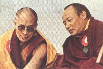
Yushu itself is known to travelers mainly as the location of the largest yearly ethnic celebration in Western China (or East Tibet), however there is also the magnificent Yushu Monastery which is situated on a hilltop North of the Town overlooking the Valley. Do not miss out on a visit to the Monastery if you are in Town (although the recent earthquake has once more damaged the Monastery severly). As you will find only slighly hinted at or completely ignored by your Tour Guide and most Travel Guides, especially the Chinese written and edited, Yushu Region is the birth region of Jetsun Jamphel Ngawang Lobsang Yeshe Tenzin Gyatso, usually shortened to Tenzin Gyatso (born Lhamo Döndrub) aka the current 14th Dalai Lama. The Dalai Lama was (re)born (re-incarnated) on July the 6Th of 1935 in Amdo Region of Tibet, and it is he who is currently the most important religious figure the Yushu Monastery has seen in its history. Enjoy the Tour and wonder about Yushu and the extra-ordinary Life of the Dalai Lama.
Among Tibetans the Town and Region are also known as 'the source of the Rivers', meaning that according to Tibetans the life giving water of the three most important rivers in China and South-East Asia flow from this source region. The Rivers in case are of course in order of importance, the Yangtze River (Jiangtse Jiang), the Yellow River (Huang He) and the Lancang River, which more southernly outside Tibet and China is known as the Mekong River.
Although technically speaking this is not entirely true (the Yangzte River source lies considerably more to the West) however even more than these three main rivers sprout from the Yushu Region, so it is truly an important source of water.
Visiting the true source of the Yellow River in Qumarleb County (of YushuPrefecture) requires a well-prepared expedition using 4 wheeled vehicles and possibly horse or mule. An attempt can best be made during the summer months when weather is fairest, however the warm weather creates the disadvantage of melting permafrost, turning the unpaved trail to the source near the foot of Bayan Har Shan into a swamp.
Yushu can today be reached from Xiningby aircraft,howeverinthiscaseonemissesoutontheYellowRiver.
Apart from Yushu the ethnic Jewel in the richly decorated ethnic crown of Qinghai Province, there are various other locations of interest to be visited in these sparsely inhabited high-altitude regions.
Already mentioned is the Ngoring Lake near Madoi.
The Tibetan word for the lake translate as “ long blue lake” which describes the view of the lake as it is during the bright but short summers in region. The Ngoring Lake is not easily reached as it lies at a staggering 4.272 meters above sea level. The blue colors of the Lake are caused by its salinity. With a surface area of 610 square kilometres, the lake is large but surprsingly shallow with an average depth of only 17.6 meters. Regardless, the lake(s) hide some significant treasures.
Today they also serve as a protected wildlife sanctuary for a rare species of fish known as the Platypharodon extremus. The fish was first identified in this lake in 1891 AD, and is only found in Qinghai Tibet. Furthermore, not visible to anyone an ancient ice lens is buried under the North Rim of the Ngoring Lake. In 2007 AD, this ice-sheet was determined to be a kind of deep-buried lake ice, formed some 35.000 to 45.000 years ago, at which time the annual mean air temperature upon the Eastern Tibetan Plateaux (Qinghai) was about −10°Celcius, considerably lower than today.
The Ngoring Lake together with adjacent Gyaring Lake are considered Holy Entities in the traditions of The Tibetan People.
The scenery of the Lake is truly magnificent, with on wind-free days a mirror like salty lake reflecting snow-capped mountain peaks in the distance. Magnificent scenery is to be found year-round, however, the wildlife the Lake is specifically famous for can best be seen in abundance during the breeding season of migratory birds, when the lake-region is teeming with life and otherwise rare
Originally Niao Dao was indeed an Island, however this is no longer the case as the water-levels in Qinghai lake have since dropped significantly. Today only one true island remains in the Lake, which can be visited by means of small boat tour which takes visitors around the Island and along main scenic views of the lake and scenery. Stay-overs are required for a proper bird-watching experience at Niao Dao.
Those who come to view the rare birds that visit the region do so mainly from May until early June during the breeding season. At other times wildlife is sparse, the birds have once more taken to the skies and visits are likely uneventful.
The Fourth impressive and worthwhile Landmark and Monument to visit in the Xining Region is the Longyang Gorge of the Yellow River with its largest man-made lake in China, highest Dam in Asia, and the second largest hydro-electric power-station in China.
Nevertheless,unemploymentishighandlarge swaths of Qinghai Province are qualified by the National Government as impoverished. ManypoorvillagershavebecomemigrantsworkersinthefactoriesandcitiesofSouth-Chinaandthecoast.ManynativesoftheregionaredisgruntledandfeeluneasywithwhattheyseeasaninvasionofHanimmigrantswho-through better education and opportunity- takethebetterjobsintheProvince.InthisrespecttheXinzangRailwayandplannedmodernizedAirportofLhasahaveonlyservedtoaggravatetensions.
The Qinghai Earthquake that struck the already impoverished region of Gyegu or Yushu Tibetan Autonomous County in south Qinghai on April 14Th 2010 has killed over 2200 people
and rendered further 10 thousands homeless and in need of shelter and further help. Although the first response fase of the disaster response has been completed, the suffering for local inhabitants continues. Left homeless, many have been evacuated to other area's and cities. Throughout 2010 and possibly beyond reconstruction will be underway. Electricity has been restored to region since a few days after the main
The Gyaring and Ngoring Lake lie inside the administrative unit of the Golog (or Guoluo) Tibetan Autonomous Prefecture (simplified Chinese: 果洛藏族自治州) an impoverished region which is also known (mainly among biologists) for the presence of its Sanjiangyuan National Nature Reserve (SNNR) (三江源国家级自然保护区).
In reality this large Wildlife and Ecological Reserve is spread across the Prefecture and includes many other area's within southern and eastern parts of Qinghai however the Regions east of Ngoring Lake, the Amnye Machin Mountains (Kekexili) and the source of the Yellow River are the most easily accessible regions.
The significance of the Park lies in the unique international approach that is used to mange this large region, and hopefully shield it from the negative influences of human development. Among things mining, construction, hunting and herding in these regions are strictly managed and monitored. In the most restricted zones almost no human activities are allowed. As these are also among the wildest regions in China, there is little risk of trespassing or disturbance by none locals.
In Total the 'Park' covers a surface area of about 363,000 km2, which makes up exactly 50.4% of Qinghai.
Included in it wholly or partially are 18 counties of the four Tibetan Autonomous Prefectures Yushu, Guoluo, Hainan, and Huangnan, and Haixi Mongol and Tibetan Autonomous Prefecture.
The Story of the Invasion of Tibet by Chinese Forces and the subsequent Flight of the Dalai Lama. Must See ! - No longer available.
Left on Photo; H.H. The 14Th Dalai Lama.
On July the 6Th of 1935 the village of Takster or Hongya Cun (红崖村) in Amdo Region of Tibet (today South-East Qinghai's Ping'An County of Haidong Tibetan Autonomous Prefecture (海东地区)), saw the birth of one Lhamo Döndrub, who according to Tibetan Religious Beliefs was found to be the re-incarnation of the Dalai Lama, a 'Living Buddha'. He lives today as Gyalwa Tenzin Gyatso or H.H. the 14Th Dalai Lama and is widely respected and revered by Tibetans and others around the World. The Tibetan Government in Exile is located in Dharamsala, North India.
In 1950 AD, the Chinese Army launched an armed invasion into independent Amdo and Khamdo regions (Provinces) of Tibet, defeating a small but chanceless Tibetan armed force hurriedly assembled in defense of the Nation.
In 1951, a seventeen point agreement between the Tibetan Government and the People's Republic of China, putting Chinese proposed policies into effect.
Armed resistance broke out in Amdo and eastern Kham in June 1956.
In 1 March 1959 a large scale uprising occurred throughout all Tibetan regions in response to rumors of a Chinese kidnapping plot involving the whisking away of the Dalai Lama, the Nations spiritual Leader, to Beijing. Not long after the Dalai Lama fled to Nepal and India beyond, establishing a Government in Exile, and leaving Tibet and the Tibetans -for the time being- under the rule and control of the Peoples Republic of China and its Government.
In 1991 AD a sizeable earthquake struck the Xining Region, destroying large parts of the Kumbum (or Ta'Er) Monastery.
March the 10Th of 2008, the 49th anniversary of the failed uprising in 1959 in Tibet saw the rising of large scale protest in Tibet Autonomous Region which subsequently spread to all native Tibetan Regions within the Peoples Republic of China. Although suppressed, tensions between Tibetans, Han and Hui simmer.
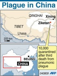
In early august of 2009 AD parts of East Qinghai saw a micro-epidemic and scare of the bubonic plague (yersinia pestis), a relatively rare but lethal infectious disease also known as the 'Black Death' for the skin lesions involved.
The provincial government quarantined the small town of Ziketan (near Xinghai) with a population 10.000 souls. The first patient was a 32 year old nomadic herdsman who died not much later. In total three people in Qinghai are reported to have succumbed to the bubonic plague, all relatives of the first patient, and another 11 people were confirmed infected with the deadly lung infection and sickened during the course of the plague scare.
The government moved to quarantine the town and started wide-scale disinfection operations which were succesful in preventing further spread of this airborne disease.
On April 14Th of 2010 a 6.9 scale earthquake struck the Yushu County and wider Qinghai Region devastating Towns.
For more Information on the History of Qinghai as a part of the Region of Tibet, please read:
As stipulated by the Government of the Peoples Republic of China in the Section 'Tibet as an inseparable part of China' part of the document 'Tibet - The 'Roof of the World' , from the series China - Facts & Figures ; ISBN: 7-119-01259-2 / Z502 and Published by Beijing Foreign Language Press (BFL) in 1990 AD, Beijing :
"Historical changes and Development
China is a united multi-ethnic country that has been formed through longstanding cooperation between Hans and Tibetans, Mongolians, Uygurs and many other nationalities. Friendly contacts between the Tibetan People and the people of other nationalities, mainly Han, began long ago.
In the early 7Th Century, Tibetan National hero Songtsen Gampo unified Tibet and founded the Tufan Regime, with Lhasa as the capital. Songtsen Gampo paid great attention to the advanced production technologies and outstanding political and cultural achievements of the Han People and sent envoys to the Tang Dynasty Emperors to seek marriage alliance.
In 641 AD Emperor Taizong sent special envoys to escort Princess Wen Cheng to Tibet to marry Songtsen Gampo. Then the Tang Emperor sent a large number of Han craftsmen to Tibet, which promoted the development and the economy and culture of Tibet.
In 710 AD responding to the request of King Chide Zugdan of Tibet, the Tang Emperor Zongzong sent Princess Jin Cheng to Tibet to marry him. Afterwards they often sent envoys to each other.
In 821 and 822 AD the envoys of the two Governments met twice in Chang'An (present day Xi'An) and Lhasa to form an alliance and created a tablet that is still in front of Lhasa's Jokhang Monastery today. The inscription on the stele describes the friendship between the Han and the Tibetan People.
In the middle of the 9Th Century, Tibet was split because of internal conflicts. The King of Tufan was assassinated by religious believers. Since then Tibet was divided into numerous Tribes that fought eachother for about 400 years.
In 1253 AD, Emperor Xianzong of the Yuan Dynasty (1271 AD - 1368 AD) sent troops to Tibet to end the confusion and unified Tibet. From then on Tibet fell under the jurisdiction of the Yuan Dynasty and became a part of China
(Note ChinaReport.com : China was at that Time a Mongol Territory known as the Cathay Khanate. This made China part of Mongolia). In 1260 AD Kublai Khan made the Sagya Leader Basaba the State Tutor (later the Imperial Tutor (in China at the Court in Khanbalik=Beijing) .
In 1264 AD, the Buddhist Affairs Administrative Office was founded, and Basaba was made director of the office and put in charge of the work of Budhism in the country and of the affairs of Tibet. Three Pacification Commissioners Offices were established in Tibet during the Yuan Dynasty, which were the first ooficial organizational system establsihed by the central government to excercise complete sovereignty over Tibet.
In 1268 AD, Kublai Khan sent officials to Tibet to establish census register and fix taxes. Thirteen Wanhu (an official with an enfeoffment of 10.000 households) were appointed, and Sagya officials were appointed to supervise the collection of taxes. A local administrative management system of combining political power with religion was establishment under the jurisdiction of the Central Government.
In the middle of the Fourteenth century (1300 to 1400 AD), the Yuan Dynasty was replaced by the Ming. In regard to Tibet, the Government of the Ming Dynasty (1368 AD - 1644 AD) basically followed the administrative method of the Yuan. According to statistics from the Board of Rites of the Ming Dynasty, about 3000 to 4000 Tibetans came to the capital (Beijing) to pay their tribute each year in the 6Th decade of the 15Th Century. During the 300 year rule of the Ming Dynasty, the Tibetan and Han Peoples lived in harmony, promoting the stable development of the country.
In the middle of the seventeenth century, the Qing Dynasty (1644AD - 1911AD) replaced the Ming Dynasty and strengthened the administration of Tibet. Emperors Shunzi and Kangxi conferred in 1653 AD and 1713 AD the titles Dalai Lama and Bainqen Erdini (Panchen Lama) of the Gelugpa sect on the two Living Buddhas. From then on the positions of Dalai and Bainqen were confirmed by the Central Regime (I.e. the Chinese Emperor).
In 1728 AD, the Qing Regime sent an Imperial Commissioner to be stationed in Tibet, and in 1751 AD the Tibetan local Government was established.
In 1793 AD, the Imperially Approved Regulations concerning Tibetan Affairs were issued. It stipulated that the Imperial Commissioner stationed in Tibet conduct Tibetan affairs together with Dalai and Bainqen. Regulations concerning Government officials, the military, the administration of Justice, defense,
public finance and so were also stipulated in explicit terms.
In the 1720's and 1790's the Qing Government used military force twice in Tibet. The first time it put down the rebellion of the Junggar Tribesmen from Mongolia and the second time it counter-attacked the incursion by the Ghurka's winning complete victory in both operations.
In 1888 AD and 1904 AD Britain sent troops directly to invade Tibet which the Tibetan People fought firmly against with their primitive weapons. Unfortunatly the struggle failed because of the corrupt Qing Government, although Tibet did not become a colony of the Imperialists.
After the Qing Dynasty fell in 1911 AD, the imperialists attempted to train trusted followers in the higher ruling group to take advantage of the Civil War in China's inland and instigate the fight for the independence of Tibet. However, this attempt to seperate Tibet from China was frustrated by the Tibetan People and other patriotic personages of China.
In 1930, the Kuomintang Government sent officials to Tibet to make connections and in the same year the Tibetan local government also sent a representative to Nanjing (then the seat of the 'Kuomintang National Government'which was at war with the Communist Party of China) and set up a resident Tibetan Office there.
In 1934 AD, the Kuomintang government sent officials from the Mongolian and Tibetan Affairs Committee to Tibet to handle Tibetan affairs.
The ascension of the 14Th Dalai Lama in 1940 AD and that of the 10Th Bainqen Erdini in 1949 AD were approved by the central government (in 1940 by the Kuomintang National Government led by Chiang-Kai Chek, in 1949 - under research) according to the old system, and both the ceremonies were presided over by the president of the Mongolian and Tibetan Affairs Committee.
Thus history shows that Tibet (and thus Qinghai) has been part of China's territory since ancient Times.
Groups in the West and in other parts of the country. The ethnic groups involved are mainly the Hui(hui), the Tibetans and the Uygurs, who agitate against the Han immigrants to the Region (and their peers in Government) as well as against each other.
In order not to further feed discussions on the Independence of Tibet from The Peoples Republic of China, the Great Wall of China sections within eastern Qinghai designating an ancient border with the Tibetan Territories may go under-advertised.
The Great Wall of China reaches its Highest Point somewhere between Lanzhou, the Capital of neighboring Gansu Province and the City of Wuwei (Liangzhou) in the Hexi
Corridor in Gansu Province, due North of Xining. Around the City of Wuwei many remnants of the ancient Great Wall can be found (Read: Wuwei Report-section). From the 3000 meter high pass south-east of Wuwei on down onto the Tibetan Plateaux and into current-day Qinghai Province of China runs a secondary root of the Great Wall. This is the Great Wall of China marking the border with the Territories since the Tang Dynasty (618 AD - 907 AD) (intermittently) under autonomous rule of the 'Kings of Tibet' (as they are known in China today).
The Great Wall near Xining was re-discovered by the Non-Chinese via the grand journey undertaken by William Geil along the Great Wall of China in 1908 AD, recording and delivering the first Foreign Photos of the Great Wall of China in its (almost) entirety. According to Geil's original writings, his party followed the Wall southward from the Pass near Wuwei to reach 'the site with 10.000 depictions (of the Buddha) near the Kumbum (Ta'Er) Monastery, located some 26 kilometers from Xining. As described by Geil, this section of the Great Wall was un-mapped at the time, and the Geil Party examined a section which they found at 5 kilometers due south-west of the Kumbum Monastery. At this location the Wall was measured to be 3 meters in thickness and still reaching some 6 meters in height along this particular stretch.
What was dubbed the 'Tibetan Curve' by Geil, then leads further southward to meet up with the Yellow River which thunders through the Tibetan Plateaux at high speed presenting an unpassable barrier at the thus historically famous Longyang Gorge. Thus a bypass of the Hexi Corridor defenses was effectively plugged. Today the Fourth Landmark and Monument to visit in the Xining Region the Longyang Gorge of the Yellow River is home to the largest man-made lake in China, the highest Dam in Asia, and the second largest hydro-electric power-station in China. The exact locations of Great Wall remnants near and along Longyang Gorge and the
routes to them are not clear. DrBen.Net & ChinaReport.com are planning an expedition to find out the necessary further information.
One of the most notable sections of the Yellow River can be found only a 150 kilometers south of the provincial Capital Xining in Gonghe County. This section, known as the Longyang Gorge (Longyang Xia), is a famous part of the upper reaches of Yellow River. Not only is the Longyang Gorge situated at an altitude of 2.700 meters (8,858 feet) above sea level it is also the largest man-made reservoir (383 square kilometers) in the Nation. The Lake was created by the construction of the the highest dam in Asia which is some 1,227 meters long and 178 meters (about 584 feet) high and includes the second largest hydro-electric power-station in The Peoples Republic of China.
'Longyang' means 'the steep cliff and clough' in Tibetan language and the Longyang Gorge was famous in history as a narrow gorge through which the Yellow River thundered passed as an impressively angered and monumental flow. Originally the Longyang Gorge is some 40 kilometers (24.85 miles) in Length and extremely narrow measuring only 40 meters (131.23 feet) in width at its narrowest point.
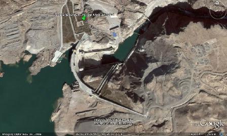
Google generated Satellite Image Map of the Longyangxia Dam, and China's 2nd largest hydro-electric dam in Qinghai Province. Today a new tourist attraction. Much of the historic sites along the Historic Longyang Gorge o/t Yellow River were forever destroyed and/or submerged beneath the Dam Lake.
- CLICK IMAGE TO GO TO FULL VERSION !! -
The dam of Longyang Gorge is the first hydropower station in the upper flow (1/3) of the Yellow River and should be regarded as one of the most modern monuments of Qinghai Province. Thus it is certainly worth a visit.