Ethnic Minorities in Guangzhou & Prefecture
Learn More about the Ethnic Nationalities in Guangzhou ...
Guangzhou Today :
History of Guangzhou:
Guangzhou Climate & Weather :
Guangzhou Basic Knowledge :
To The China Report Main Menu
This page was last updated on: May 13, 2017
The Guangzhou Report
45007
Introduction to Guangzhou (广州)
Guangzhou Landmarks & Monuments
Guangzhou City & Area Maps
Location : (....)
Elevation : 2275 Meters.
Surface Area:
Urban - xxx
City Prefecture of Guangzhou - ?? sq Kilometers (?? sq miles)
Population: The Total Urban Population of Guangzhou is around ?? with an additional xxx living in the rural area's of the City Prefecture.
Go to www.drben.net webring
To Main Menu of All Websites at DrBen.Net
ChinaReport.com at
Alphabetically ordered list of Monuments, Landmarks and other sites of interest in and Around Xining
A Full listing of Guangzhou City Landmarks, Monuments, Hotspots and other sites of importance in alphabetical order. Search through the list to find your Full Report and Photo-Virtual Tour of each monument or landmark within the City, or Region of Guangzhou in Guangdong Province of China (PRC).
Public Transport in Guangzhou
Main Railroad Station of Yinchuan - Photos and Introduction
There is no information available on the Main and only Railway Station of Guangzhou is.
National Airport at Yinchuan - More information
Book Hostels Online Now
Complete Listing of available Hotels in Guangzhou, Guangdong Province, China (PRC).
Click to Go to Large Scale Map 1A
Guangzhou has a Railroad Station as well as a National Airport.
More information Coming Soon !!
History :
Shang Dynasty
Zhou Dynasty
Han Dynasty
Tang Dynasty
Ming Dynasty
Ching Dynasty
Guangzhou is a City with a rich history. More information on the history of Guangzhou is coming soon!
No information available at this Time.
Find out the Details in the History of Guangzhou
follow me on Twitter
There is no information available on the Ethnic Minorities of Guangzhou City and Prefecture at this Time.
There is no information available on Hotels in Guangzhou City and Prefecture at this Time.
No information available at this Time.
Click Map to go to Full Version !!
Map showing the 7 Military Commands or Districts in China including the District of Lanzhou which extends all the way to the West and includes Xinjiang AR and parts of Tibet (historical).
Lanzhou - 7Th Military Command
Click Map to go to Full Sized Version !
Bokhara (Bucharra)
Jidda
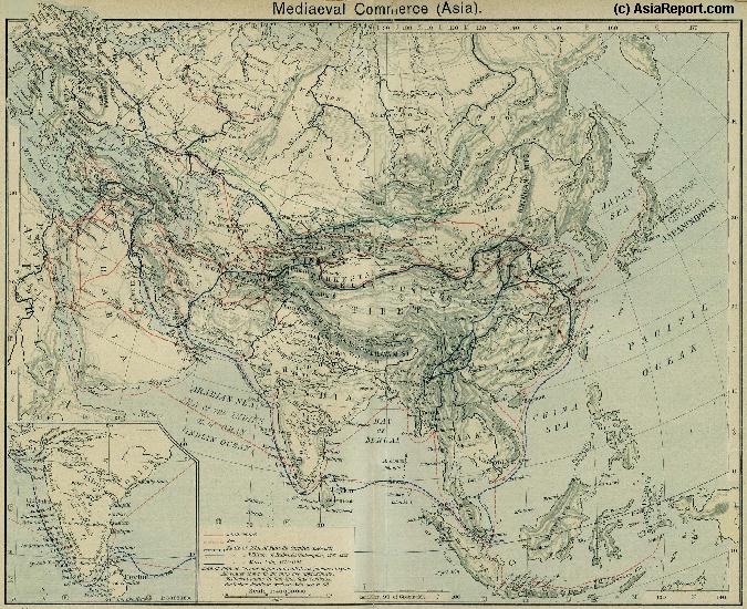
A Schematic Map of the Eurasian Trade Routes existing in the 13Th Century (Yuan Dynasty).
Clearly depicted on the Map are the land-bound trading routes through Central Asia known as the Silk Road (the path of Marco Polo and others) and the Maritime Trade Routes that operated between the Arabian Peninsula, the Indian Ocean and Coastal Cities, the Straights of Malacca and South-China Sea's. As shown Maritime Trade to China mainly entered through Southern Harbors, then was distributed internally by use of the Grand Canal, the Yangzte River and the Yellow River.
- CLICK MAP TO GO TO FULL VERSION -
Beijing
ZaiTun (Quanzhou, Fujian Province)
NanKing (Nanjing, Jiangsu Province)
Canton (Guangzhou, Guangdong Province)
LuoYang (Henan Province)
Ningxia (Fu)
Malacca
Jofna (Island)
Cochin
Calicut
Chintabor (Goa)
DaiBuk
Muscat
Aden
Mecca
Medina
Kasseir
Zafa
Baghdad
Ispahan
Ormuz
Xining (Fu)
Khotan or Hotan (Hetien)
Yarkant
Kashgar
Balkh
Samarkand
Saracanco
Stilarcitracan (AstraKhan)
Baku
Sevastopol
NingPo
Kesho (Hanoi)
Champa
Bahrain
Astrabad
Meshed
Herat
Beijing, Capital of China (PRC)
Luoyang, Henan Province
Xian, Shaanxi Province
Shanghai City Province
anjing, Capital of Jiangsu Province
Hangzhou, Capital of Zhejiang Province
Guangzhou, Capital of Guangdong Province
Hong Kong, S.A.R.
Fuzhou, Capital of Fujian Province
Luoyang, Capital of Sichuan Province
Yinchuan, Capital of Ningxia Hui Autonomous Region
Find DrBen and ChinaReport on Facebook with the latest from www.drben.net.
DrBen Nijhoff | Maak je eigen badge
Hangzhou, Capital of Zhejiang Province
Xian, Capital of Shaanxi Province
Beijing (Peking), Capital of China
Nanjing (Nanking), Capital of Jiangsu Province
Click Image to Enlarge !!
Guangdong Prov.
Guangdong Prov. Home
Guangdong Sources
Guangdong Maps
Guangzhou
Guangzhou Home
AsiaReport.com Home
China Offline Sources
China Report Home
China Online Sources
China Online Store
China Maps
China
China Photo Galleries
China Report Club
Huizhou
Huizhou Home
Shanwei
Shanwei Home
Shaoguan
Shaoguan Home
Shenzhen
Shenzhen Home
Meizhou
Meizhou Home
Shantou
Shanhou Home
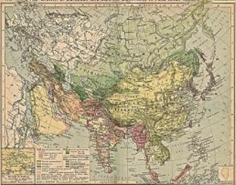
China Report - Colonialism - Growth of Colonies & Japan after 1801 AD
A Map drawing of the Eurasian continent , parts of North-East Africa and the Middle East in the 19Th Century between 1801 AD and 1900 AD. Focal points are the expansion of western colonial posessions of Portugal, Britain and France, as well as  Russia moving from West to East. Labeled seperately is the later Rise of the Empire of Japan in the East.
Included in this Map are the main cities across the continent with their brief histories and events during the 19Th Century. Marked in Colors for clarity are the various colonial and imperialist Nations. As relating to China; special attention is payed to so called Treaty Ports. The First Treaty Ports were forced open by Britain in the year 1841 AD, but counted over 80 in total by the end of the 19Th Century. The most important Treaty Ports in China are marked and described with a short history where the map allows.
Map China and Far East Colonies after 1801 AD
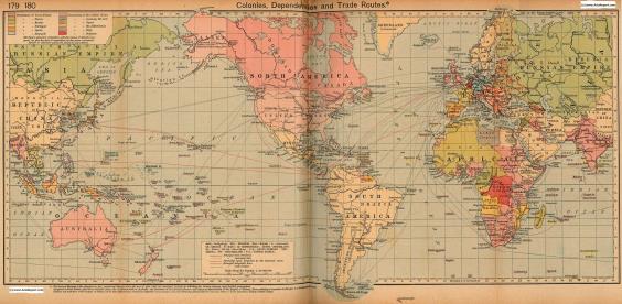
Colonialism - 1912 World Map of Colonial Possessions & Trade Routes.
A Map drawing of the World depicting the Colonial Possessions as they were distributed in 1912 AD. Superimposed and marked in colors are subsequent changes in Influences Spheres, colonies and possessions due to World War I ( 1914 AD - 1918 AD).
Included in this Map are the main cities across the continents with their brief histories and events during the late 19Th Century and early 20Th century, where relevant. Marked in Colors for clarity are the various colonial and imperialist Nations. As relating to China; special attention is payed to so called Treaty Ports. The First Treaty Ports were forced open by Britain in the year 1841 AD, but counted over 80 in total by the end of the 19Th Century.
Click through for Full Version !!
Full Google Earth Supported Map of Guangzhou

View AsiaReport.com - Mastermap of Asia (entire). in a larger map