Not much Data is easily available on the Ethnic Cultures within Gansu's Capital Lanzhou.
Many more groups live in the regions surrounding the Capital Prefecture. Among these are the Hui Muslims who are concentrated within Linxia hui Hui Autonomous County, the Tibetan minority at Tianzhu Tibetan Autonomous Township (in Yongdeng County, Lanzhou), Gannan Tibetan Autonomous County with the town of Xiahe and its famous Labrang Monastery, and members of other smaller groups such as the Bao'An, The Sala(r), the Yugur, the Dongxiang and others.
Across the nearby Provincial Borders of Qinghai Province, on the Eastern Edge of the Tibetan Plateaux are a variety of ethnic groups.
Lanzhou & City Today :
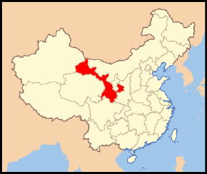
Today Lanzhou is the Provincial Capital of Gansu Province and a Prefecture Level City. The City Prefecture has 8 Divions. There are Five City Districts sprawling some 20 kilometers along the Length of the Yellow River which runs from West to East through the City. The five urban city districts are Chengguan District (城关区), Qilihe District (七里河区) , Xigu District (西固区) , Anning District (安宁区), and Honggu District (红古区). Surrounding these are the three outlying counties.
History of Lanzhou:
The history of the City of Lanzhou spans more than 2200 years. The first people to cross the river at this convenient spot arrived much earlier, but the earliest mention of the city can be found as preserved records that show a City on this location already existed during the Reign of the Ch'In (Qin) Dynasty (221 BC - 207 BC). At the time the city was part of the territory of Longxi from which it was administered.
Not much later however, Emperor Wu Di of Han sent out his diplomat Zhang Qian's on his travels (139 BC –125 BC) making him likely the first famous historic person to pass through Lanzhou. It was essentially Zhang Qian and several Han Armies who opened the initial trading road to the West that would later become the 'Silk Road'.
Surface Area: 13,1000 Square Kilometer (5,057.9 square miles).
Urban - 630 square miles.
Lanzhou's three central districts cover around 100 Square Kilometers. The urban center of the City extend some 20 kilometers along mainly the South Bank crammed in a narrow strip between River and steeply rising cliffs of the surrounding Loess Plateaux.
Population: The Total Urban Population of Lanzhou City is around 3.3 million souls, a fairly large section of whom are members of the Hui Minority. Not only are the Hui abundantly found throughout South-West Gansu Province and more to the North inside Ningxia Hui Autonomous Region, during recent years the special child-birth rights reserved for the minorities have increased their numbers relative to the Han majority population.
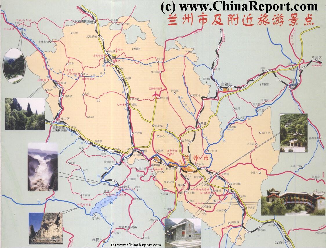
Geographic & Historic Maps on Lanzhou City, Great Wall of China, nearby Gobi Desert Satellite Image, including the position of BingLing Caves, Maji Shan, Labrang Monastry and More of the Surounding Area's.
This page was last updated on: July 24, 2017
The Lanzhou Report
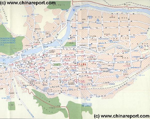
Lanzhou City & Area Maps
The China Report
The Lanzhou Report is part of the overall website www.ChinaReport.com & www.drben.net
ChinaReport.comat
Please browse around the City of Lanzhou and wider Area using our Geographic & Historic Maps. Overview Lanzhou City and Surrounding Area's, then find out more by Linking through to our many Photographic Reports on the main Historic landmarks and Monuments of Lanzhou, and their rich history.
Lanzhou PublicTransport
The City of Lanzhou can be reached from anywhere in China through direct air connections. As the arrival point for many, the Lanzhou ZhongChuan Airport is located far North and outside the City at some 70 kilometers distance. A Bus trip up to the airport takes about an hour, or more depending on traffic.
The best way to travel around the Province and appreciate its many and varied cultural and historic treasures one has to make use of Trains. Trains or Regional bus-lines that use the newly constructed highways around Lanzhou are the best modes of transport to get around to Tianshui City, Linxia Hui, Gannan Tibetan Prefecture, Hezuo and Langmusi. Trains do best to connect to the Oasis Cities of the narrow Hexi Corridor shaping the Western 'neck' of the Province.
Although there are several worthwhile historic landmarks within the Old City to visit and marvel at, there is certainly no abundance of Monuments. Although Lanzhou was an important city it never grew rich nor large until in modern times hence a certain basic lack of the grandeur found in such Cities as Beijing, Xi'an and perhaps Pingyao. To make matters worse, many of Lanzhou's old city architecture -among which many structures built from wood- was destroyed during the lenghty bombing campaign launched against the strategic city during the Sino-Japanese War (1937 AD - 1945 AD).
In a much enlarged and modernized Industrial City only the remnants of Silk Road history including the Hui and Uyghur Minorities, a few new Parks and a modern Hotel Tower overlooking the much deminished Yellow River provide new excitement and additional leisure. Although the Provincial Government has launched drive to resurrect some sort of Cultural Life in Town, there are surprisingly few theaters in the downtown area.
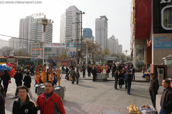
All in all, on first glance city life in Lanzhou is rather drab and uneventful. Only recent modernization drives and global development have brought foreign visitors to this otherwise non-remarkable Chinese City.
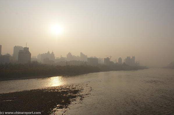
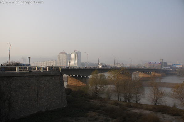
The main attraction of the City of Lanzhou must be the Yellow River itself as Lanzhou is the only Chinese City that has the Yellow River flow through its middle. The City sprawls some 20 kilometers along the River banks, so there are plenty of places to go and see the River.
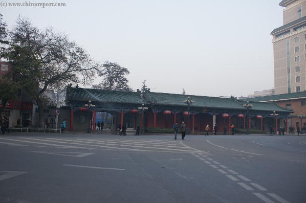
Next in Line are the Monuments of the Old City of Lanzhou, mostly located on the south-bank of the River and in the downtown area. Spaced together to mark the extenses of the original City are the ancient White Cloud TaoistPagoda , found on the South Bank and The White Dagoba Hill or Baita Shan (白塔山 ), a Temple Park reaching to a Yuan Dynasty Era Top Dagoba standing on the North Bank overlooking The River.
The most famous bridge of Lanzhou, the Zhongshan Huanghe Bridge built in 1907 AD, stretches roughly in between these two ancient landmarks connecting the banks. As the first Iron bridge built in Lanzhou to cross the river permanently it is a historic landmark all by itself.
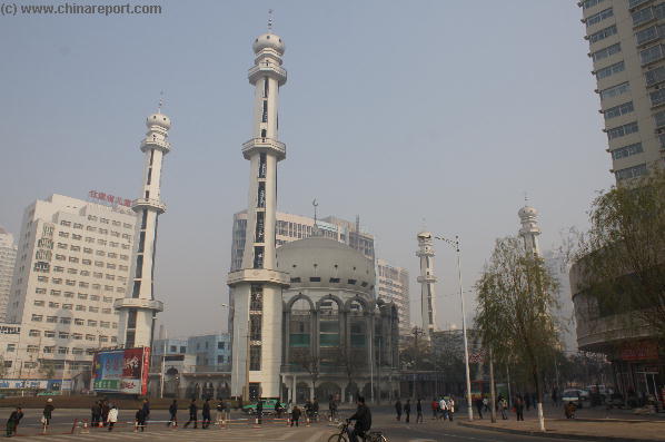
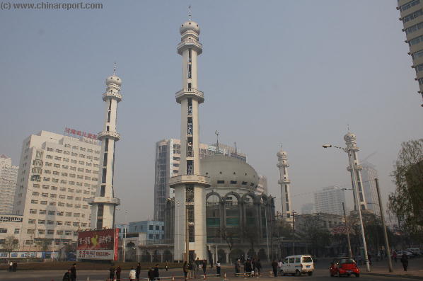
A Giant Mosque named Xiguan, West Gate in the south-west corner of the South Bank City symbolizes the millennia old connections with Central Asia and the Silk Road through the presence of the Islamic Faith and the large Hui ethnic population of Lanzhou and regions. A counterpart can be found in the Lanzhou Christian Cathedral, which is part of the independent Christian Church of
- Mouse over Image -
Music Bonus - "The Great River", By Harukanaru Taiga.
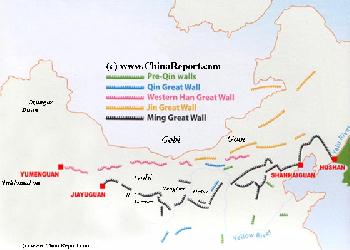
Map Great Wall China - Layers of Dynasties and Era's
A Schematic Map of China and East-Asia, with a super-imposed schematic of the various layers of the Great Wall of China.
In its long history Lanzhou was a vital Crossroads city along the ancient Silk Road. For thousands of years Camel Caravans, messengers, pilgrims, traders and many more crisscrossed the many mountain-paths of the Region, the majority of traffic crossing over the Yellow River (Huang He) at Lanzhou, the southern gateway into the 1000 mile long Hexi Corridor. On both banks of this impressive natural barrier warehouses for stockpiles arose. A busy market could be found on the Southern Bank. When the River was too wild or dangerous to cross, the traffic halted and those that had
arrived needed to find their stay in the Town on the River Banks. From this there grew a City on the River that lasts until our days.
Lanzhou is the only Chinese City through which the Yellow River flows. All other 'Yellow River Cities', such as Yinchuan in Ningxia and Luoyang, Zhengzhou and Kaifeng in Henan lie at some distance from the Yellow Rivers' waters due to its notorious tendency for dramatic overflows and major and minor shifts in the path of its flow. The Huanghe created a strange city, split in half by its waters, which due its many gorges and rapids in this region were unnavigable for shipping. The only 'roads' were mud paths, camel trails and in the south riverside passages made of bamboo platforms inserted into the sides of the Gorges. Although 'all roads' (many) in the region led to Lanzhou, connections were far from perfect. Communications were slow and the Capital and Province were cut off from most of what happened in the Central Plains of the Nation.
Thus, until very recently Lanzhou was a very remote city, the Capital of one of
Lanzhou lies inside the arid region of the Hexi Corridor and its Loess Plateux and only just North of what is known as the low-altitude green climatic zone of South Gansu Province. To the West lies another climatic zone formed by the rising slopes of the Tibetan High Plateux which stretches as far as Pakistan and Kashmir.
Although officially the Region knows a 'continental monsoon type climate' in essence the City of Lanzhou does not see much rain. Average annual rainfall is only 237 millimeters.
Due to the vicinity of several deserts and more importantly due to the Loess Plateux formed over 1000's of years by the Yellow River, dust storms are frequent in the City. Such storms arise especially in spring.
Winter seasons are cold and last from November until March. Summer Days can be searing hot due to the lack of wind in this highrise city located at the bottom of a deep Yellow River Gorge. Tree lined streets and avenue's as well as a boom in highrise construction provide for plenty of shade in the City, giving some relief. Average annual Temperature is only 11.2 degrees celcius, mind you.
Travel High Season runs from June to September.
POLLUTION:
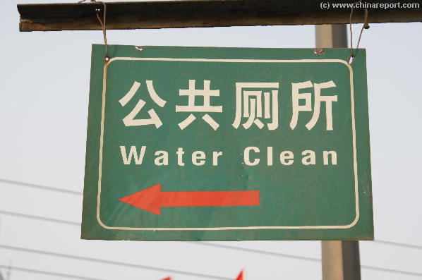
On wind free days the city becomes a boiling yellow-grey mass of pollution. Lanzhou is among the three most polluted cities in China. Water derived from the Yellow River has declined in quality throughout the 1990's and is currently undrinkable and even unusable for agriculture throughout much of its length.Some10%consistofrawsewageandindustrialwastes. You may find clean drinking water signs along the river banks, designating fresh water taps used in summer.
the most neglected Provinces of the Nation. Even as Late as during World War II Lanzhou could only be reached by road from Xi'An in Shaanxi Province. Due to other traffic, the desolate state of the roads at the Time and other factors such as floodings of local rivers and landslides, traveling from Xi'An through Baoji and Tianshui to Lanzhou might take up several weeks. Nevertheless, it was and remained the key to the Western Regions. One of the last battles in the Chinese Civil War was the Battle for Lanzhou in 1949 AD.
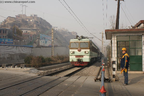
A passengertrainthunderspastslumsontheloessridgesaroundtheOldCityatthesouth-westendofZhongshanRoad.
For a Full listing and Discussion of Lanzhou City Landmarks, Monuments, Hotspots and other sites of importance in alphabetical order, please Click Through.
Search through the list to find your Full Report and Photo-Virtual Tour of each monument or landmark within the City or Area of Lanzhou, Gansu Province.
Lanzhou City Hotels
Complete Listing and Reviews of the Main Hotels in Lanzhou City, Gansu Province. The Most Famous and luxury hotels in the City are the International Silk Road Hotel, etc.
The City of Lanzhou serves important functions for both passenger travel and transport of industrial goods and materials. Thus, the city is extra-ordinarly well connected. Trains travel around the south-bank city and can be seen traveling along the loess ridges near the famous Main City Mosque. Several smaller stations and relays are found in Towns just to the south.
There are two Railway Stations in Lanzhou City, one located due South of the City Center of Lanzhou and another at some distance away in the western city.
Much has changed since China's 'Liberation' and the founding of the Peoples Republic in 1949 AD. Among the major changes for Lanzhou were the construction of the Baotou-Lanzhou Railway in 1958 AD and the opening of the Lanzhou-Urumqi railway in 1963 AD, the first unlocking Lanzhou and connecting it with the major Industrial and mining center of Baotou in Inner-Mongolia AR and the second creating a direct railway link through the Hexi Corridor with the farthest Regions in the West and the regional Capital of Urumqi. Eversince Lanzhou has re-arisen as important logistical and distribution center and gateway into western China.
Today Lanzhou is the major industrial center of the North-West with mainly Heavy Industry, Petrochemical and Pharmaceutical. Lanzhou, with its strategic location and history has become one of the 12 main logistic
points in the nation serving the entire west. It is also a major military garrison city and stronghold in the West. The city being at the Center of China's 7Th (and Last) Military District also known as the Lanzhou Commandery. This command includes nearly the entire North-West of China.
The City is rapidly growing and filled with Highrises. Recently modern highways have connected the City to Yinchuan in Ningxia AR, the Cities of the narrow Hexi Corridor and beyond to huge Xinjiang-Uyghur AR. Others lead South to Baoji in Shaanxi and into Sichuan Province. More railways make for excellent connections to any destination within China. The addition of a completely modern airport one hour North of the City make travel to Lanzhou utterly convenient and speedy. Bullet trains are planned to reach Lanzhou in 2010 AD.
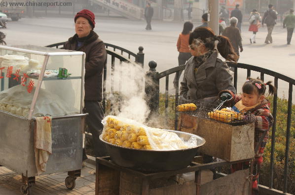
Air Pollution is rampant. A few historical landmarks on the Banks of the Yellow River as well as the presence of several minority groups in the City provide entertainment for travelers and tourists.
- Mouse over Image -
China. The Islamic Faith entered China through international shipping and through the channels of the landbound Silk Road. Although today's Mosque is a fairly modern structure only re-opened after the 'Cultural revolution' Era (1960 AD - 1976 AD), the Islamic Faith has been engrained into daily life and culture in Lanzhou. Several more mosques, great and small, can be found in the City throughout al districts.
The arrival of the Christian faith took place many centuries later. Christians only arrived in Lanzhou at a time well into the 19th Century, after China had been forced to accept their presence. Earlier during the Tang Dynasty Era (618 AD - 907 AD) some Nestorians had
So far the Main and obvious attractions of the City of Lanzhou. Naturally, many more small historic remains and reminders can be found scattered throughout the 'old' south bank city. There is a Taoist Temple on the River Bank, a hidden buddhist Dagoba of which little is known to outsiders and a few other sites with historic architecture to visit. Several of them are not listed in regular travel guides on China or even the Province. Dwell the City using Google Maps combined with this website as your guide to find them all.
The barely recognizable traditional 'Muslim Street ' can take a while to locate between the forest of skyscrapers. Keep trodding around
On another side of the City stands the Xinglong Mountain, since 2000 years revered as a spiritual and holy mountain. It used to be a Taoist Hiding Place, however since its far history the Mountain has been covered in Pagoda's and Temples, making it a pleasant place to spend a day enjoying the scenery.
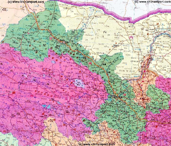
Beyond Lanzhou City Prefecture lie even more astounding Cultural and Historic Treasures. In the past nearly impossible to visit except for those willing to suffer a back-packing style experience, the recent construction of a modern highway network to reach throughout the entire Province has enabled more regular tourists to reach the (remote) ethnic Minority Towns that are strewn around Southern-Gansu Province. There are almost too many to mention. Carry on past the Bingling Caves to visit Linxia Hui Autonomous County and experience more of the Hui islamic Culture. Head out to the very Eastern edge of the Tibetan Plateaux to explore Gannan Tibetan Autonomous Prefecture(Kanlho) and find a multitude of small treasures, great sceneries and astounding China experiences.
These are certainly not the only ethnic groups represented in this region. Other living nearby or integrated with the larger minority communities are Mongolians, the Bonan Minority, The Tu Ethnic Group and the Dongxiang People. Even more ethnic peoples live slightly further away and some visitors travel from Lanzhou as far as Langmusi in North Sichuan Province to get to the purest form of Ethnic Cultures in China.
Trips to Langmusi however require overnight stay(s) at Langmusi. Travel from Lanzhou due Westward to pass through Minority Country on your way to Xining (Silung) the Capital of Qinghai Province (former Amdo region of East Tibet). There one can enjoy more of the Tibetan Culture as well as meet two additional minority groups, the Tibetan influenced Yugur and the muslim Salar.
One of the Last, but certainly not the Least historic monument that must be mentioned in Relation to Lanzhou, but which however hardly ever is, is the Great Wall of China. The main reasons for this is probably that exploring The Great Wall from Lanzhou takes quite a bit of traveling and leads to truely remote and sometimes secluded places.
Especially the Great Wall sections built in the East along the Loess Cliffs and the Yellow river gorges in that area form a challenge to reach.
In its history the City of Lanzhou served as the one of the Five Main Garrison Cities in support of the Great Wall. Its function can even be compared to the ancient Ming Capital of Beijing itself as Lanzhou served a similar pivotal function in the defenses, making it a nearly equally attractive Military target.
Lanzhou, at the south end of the dangerous Hexi Corridor -a sneak route into the Chinese heartlands-, served as the ultimate stop gap in the Western Defenses. Hence, as was Beijing, the City of Lanzhou was surrounded by multiple layers of the Great Wall. Essentially, the city was the support point for a wide ring of defenses cast around it. In fact in its History Lanzhou never had significant city walls since it sits at the bottom of a Gorge. It would have been utterly pointless to build defenses there. The defenses of a City such as Lanzhou had to be organized around the roads leading to it.
Hence, the remnants of those defenses can today be found mainly to the North, but also to
managed to make it into Western China leaving records in the West, introducing Nestorian Christianity to China in 635 AD. However by the Time Marco Polo traveled through Western Gansu (the Hexi Corridor) none of the were left to be found.
Today's a Cathedral stands not far from Dongfanghong Plaza and second one can be found near the River and Fuci Street Bridge, where it is open and active since the year 1985 AD.
Apart from the White DagobaTemple Hill(白塔山) the crowded city counts few large parks. Several smaller ones can be found stretched along the south river banks, providing an interesting hiking route. Along the East of the South Bank is the somewhat acclaimed Lanzhou Waterwheel park, the cities historic showcase of the technology that first helped irrigation of lands along the Yellow River some 2200 years ago, spawning the first seeds of Civilization along the upper reaches of the Yellow River's fertile valleys.
The Waterwheel Park is a must see sight of the City no doubt. The same goes for the Gansu Provincial Museum. Easily forgotten or overlooked while passing through the City, the provincial museum exhibits some of the finest ancient finds of the done in the Region.
Other Larger Parks are found along the outer rim of the City and Valley and take some time and effort to reach. Lanshan Park due south of the 'downtown' City is the most popular place to visit. Head there to get on top of the Loess Plateaux and appreciate some of the difficult terrain shaping this section of the Province.
the West -incase the NingxiaRegion was taken- and even to the South, offering last stance position before the central plains lay open to Foreign Enemies.
SouthGate to the Headquarters of the Gansu Public Security department atQingyangRd(andDongfanghongSquare).Itishoused in onefullblock of 'downtown' Lanzhouandusedtobealargemansion.Todaytheblockisfullymodernized. OnlytheGateremains.
the west side of Chengguan District ('Old Lanzhou') and look out for the typical white Hui head caps. Inside the street is another important Mosque and Islamic
Seminary. Don't expect too much. The Hui have modernized too !
Apart from these important City Monuments the Real Treasures of the City of Lanzhou are all located outside the Urban Area. In the wider City Prefecture and beyond there are a multitude of interesting towns and places to visit. In fact, for those willing to make the effort there is an oustanding variety of amazing things to do and see in the wider Region. At the top of the List of the Excursions to be made from Lanzhou are trips to Bingling Si and the LiuXiajia reservoir of the Yellow River. Although will take an entire day of your itenerary, the trip will certainly be worth your while. The BingLing Caves and Statues are among the most famous such Monuments of The Silk Road and history. On top of that, they are reachable over water only making it a truly unique location.
Lanzhou's Fuci Street Bridge, main road traffic arteryacross the Yellow river, eastanddownstream of Zhongshan Bridge in the Chengguan District. (Photo:November2007).
An internationally published article of the The Times written in September 1999 qualifies Lanzhou as 'a bleak city in Gansu province that last year earned the dubious distinction of being the world's most polluted city, according to the World Resources Institute in Washington'.
'Lanzhou has plenty of national company: eight other Chinese metropolises rank among the institute's top 10 list of cities with unbreathable air'.
As mentioned Lanzhou serves as the headquarters of the 7th Miltary Command, the largest military region in the PRC in terms of geographical area. The Military Headquarters in Lanzhou directs all military and armed police forces in Xinjiang-Uyghur AR, Qinghai Province,Gansu Province, Ningxia Hui Autonomous Region, and Shaanxi Province. The Ali (Ngari) area in the High Himalayan Mountains of northwest Tibet also falls under this Military Regionial Command. It is bordered to the south by the Chengdu Military Region, and to the north by the Republic of Mongolia, the Altai Republic, which is a province of the Russian Federation, and Kazakhstan.
The Lanzhou Garrison itself is stationed someways South of Lanzhou in Linxia, the administrative capital of Linxia Hui Autonomous County.
A few years ago the International Institute for Strategic Studies attributes an estimated 220,000 personnel to the Lanzhou Military Command. Among these a single armoured division, two motorised infantry divisions, one artillery division, one armoured brigade, two motorised infantry brigades, one artillery brigade, one anti-aircraft brigade plus a single anti-tank regiment. Howover much has changed while the army modernizes. Unrests in the Western region of Xinjiang and in Tibet Autonomous Region may have led to additional changes.
The Command of the Lanzhou Military Region includes 2 Group Armies. These are the 21st at Baoji and the 47th at Lintong due East of Xi'An. In addition there are two Armed Police Units, the 7th and 63rd. Known smaller formations include the 12th Armoured Division ('84701 Unit') which is stationed at Jiuquan, inside the Hexi-Corridor of West Gansu. The region also includes the Xinjiang Military District, unusual among PRC military districts in that it contains a significant number of combat troops (the 4th Infantry Division, 6th Infantry Division, 8th Infantry Division, and, apparently, the 11th Highland Motorised Infantry Division. There are no fixed positions or garrison towns known for the units, however reportedly some are currently stationed at Urumqi and others in defense of the border in the Karakoram Mountains.
The Chinese Language spoken in Lanzhou is the regional version of the mandarin Language known as Gansuhua. It is sometimes difficult to comprehend the dialect.
Even in Lanzhou however many now speak at least a word of English. As the regional main city it is also home to Lanzhou University, the Agricultural University as well as a host of other educational institutes. The students are often eager to have a chat and are the most foreigner friendly group in town. They may be very helpful when you find yourselves lost at some point somewhere between the high rises.
ForfirsttimevisitorstotheCitytheChengguan District (城关区) mattersmost.Thisistheoriginalspaceofthe'OldCity'ofLanzhou,whichwasnearlyalloftheCityuntilitexpandedafter1949ADandthebeginningofthenewEraofthePeoples'Republic.
The Chengguan 'Old City' comprises parts of the South Bank and the North Bank of the Yellow River and takes up the river Gorge area with the widest bank and thus construction space for inhabitants. This is the kilometers long 'dowtown' area to which most roads leads. It spans roughly between the Xiguan - West Gate Mosque in the West, the back of the White Dagoba Mountain on the North Bank, the Tianshui Road Bridge - Lanzhou's largest bridge- located downstream and a bit North around the corner from the city, and finally the Southern Mountain (Lan Shan) atop which are no less than two parks.
The Chengguan District, as original city, has most of the
historic landmarks and monuments. It is also home to the Cities Government,whichisarrangedinthewesthalfsectionaroundDongFangHongPlaza. Importantfacilitiesarethe first and MainRailroadStationofLanzhou along the south rim of the Gorge,the Campus of Lanzhou University in the East, the North-West University for Minorities and the Agricultural University of Gansu Province.
Downstream from the Chengguan District lies the recently constructed yellow river highway bridge, after which the Yellow River turns northward to lead through narrow gorges into the Eastern sections of Gansu Province. There are no readily available spaces to develop downstream from the Old City, hence the City when it expanded grew upstream along the River banks.
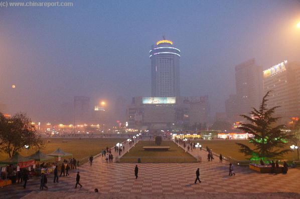
The Cities main commercial square and 'cultural center', the sprawling Dongfanghong Plaza in the center of West Chengguan District (Photo: November 2007).
bank.TheQiliheDistrictliesexclusivelyonthesouthbankoftheriverastheNorthBank at this height of the river gorge istakenupbyhuge nearly barrenloesshill. Roughly Qilihe District is demarcated by the Xiguan Mosque on its Eastern End and the Yintan Bridge on the Western upstream end. Essentiallythe western upstream half ofQiliheis a suburbanliving districtwherethereislittleofexcitementtobefound.
InQiliheDistrictstandtheLanzhouWesternTrainStationandsomeothermodernfacilitiesoftheCity.ItisalsothehomedistrictoftheGansuProvincialMuseum, the Lanzhou University of Technology and Lanzhou Polytechnical University.
Yongdeng County (永登县)liesdueNorth-WestoftheRiverGorgeandtheFourCityUrbandistrictsinsideofit.Most of its space is taken up by broken ridges and platforms of the Loess plateaux and generally speaking, apart from the railway and the few roads there is nothing much to see out-there. The are only sparse, dusty and poor looking villages hidden among the ridges and ravines.
There are no jewels to be found, except for the shining Tibetan Enclave of Tianzhu (天祝藏族自治县) part of the Amdo Region of historic Tibet.
Apart from the bright and colorful costumes of the Tibetans,Tu,Hui and Zang Minority, their is plenty to experience of their Culture and Folklore. Apart from a modest tourist industry helping to keep minority culture alive, the Tibetans of Tianzhu have also modernized. Around the town and region are plenty of green houses using advanced agricultural methods to grow the proud and tasty red grapes of Tianzhu. Hence, one of the best times to visit during the entire year is on and around January 15th when the red grape harvest festival is held in Tianzhu County.
Other inhabitants still cling to the tibetan nomadic tradition by raising herds or at least being involved with animals. Since 2007 there is a large eco-friendly greenhouse farm for raising sheep and cattle.
Tianzhu is also famous for its unique white yaks which now number 41,500 (only 4000 pure Tianzhu Blood).
Most of them can be found near Zhuaxixiulong town.
Interestingly, recently some 'rodent' fossils dating to the pliocene were found at a remote red clay cliff near Tianzhu.
The Autonomous County has approximately 230,000 inhabitants (2003). Its administrative seat ("capital") is the town of Huazangsi. China National Highway 312 (312国道), also referred to as Route 312 or The Mother Road leads out of Lanzhou towards Tianzhu.
Gaolan County (皋兰县) is the district which lies due North of the City and the Yellow River Gorge, covering the region between the original City of Lanzhou, Chengguang District, and the City of Baiyin. The town of Gaolan sits about halfway between bothcities.
The Yuzhong County (榆中县) District finally lies to the South-West of Lanzhou, covering the approaches to the Cities Chengguan District and including its gateway pass. Unlike the 'Old City' the Yuzhong County is rough almost mountainous terrain consisting of hills and eroded slopes of the loess plateaux. It is not an urban district but rather a drab collection of villages crammed along the steep valley slopes. The main entrance is formed by the Liuzhong Expressway which cuts down from the South-East corner of Chengguan District ('Downtown') and has a road leading to Hepingzhen, the main collection of buildings, together with a highway flyover demarkating the North End and beginning of the Changli Expressway.
The only other road into Yuzhong County starts all the way on the other end of 'Downtown', in the West leading south as Road 101 from the front of the XiGuan Mosque. Alongside it in the west a railroad follows the same trajectory due southward. This route passes through Leitanhe, underneath the Lanshan Mountain and Senlin Park, to pass through Balizhen Village. Hardly anyone non-local goes as far Leitanhe, let alone beyond.
TheAnning District (安宁区)liesimmediatlyacross the River fromtheQiliheDistricttakinguptheNorth-BankoftheCitysomewaysupstreamfromtheWhiteDagobaMountain(BaitaShan). It is home to the Lanzhou Electric Power School, Lanzhou Jiatong University as well as the North-West Normal University. If anything, the Anning District is the University District of Town, although due to the multitude of educational institutes in the City with a wide regional function, students can be found in flocks anywhere in the City. They especially throng to Parks, the River Banks and the sparse Musea and Galleries of the City, brightening up the City life. No wonder they are eager to do so, as there is not much excitement or entertainment to be found in this large, somewhat old styled Chinese City. Here in the far west one must make ones own entertainment. Anning District is also the Lanzhou's economic development zone and the home of arious Industries.
The location of the Honggu District (红古区) may not be immediatly clear from your city map or even Google Maps. Do not be too surpised or concerned. In fact, the Honggu District can not be considered a true part of the City of Lanzhou since it is only connected to the City by one main road, does not lie inside the Yellow River valley of Lanzhou and is in fact many miles away from even Xigu District, the most upstream section of what can be recognized as the Urban Area (while on the ground).
Honggu together with the Town of Minhe immediatly East of it together make up an ethnic community of the Hui People, hence their city district status. Minhe even has its own autonomous Hui city district Government, for what its worth.
Both Towns lie about halfway the distance to Xining, the nearby Capital of Qinghai province.
The Best way to reach these two Towns which lie North-East by East from the City is to take to the Lanhai expressway (G 109 Road) and follow it north around the city to Ping'An(zhen) and from there on to your destination. There are also trains from both the main station in Chengguan District and the Western Railway Station in Qilihe District.
In the North the defenses and Patrol Area of the Lanzhou Garrison ended as far away as the Yumen, the famous Jade Gate of the Han Dynasty Era North-West of Dunhuang in Gansu. In The Han Dynasty and during the much later Tang Dynasty this had been regarded as the ultimate western end and border of China. Although the real Empire may have stretched far beyond, those were all regarded as barbarian lands.
In the early Ming Dynasty, after the Ming armies had driven the Yuan loyalists out through the North End of the Hexi Mountain Passage, an entire Fortress was built there at Jiayuguan, to form the end of The Great Wall of China in the West. The small town, which sits close the north end of the 1000 kilometer long Hexi Corridor, then became the western border town of China and remained so until well into the 20Th Century. Named 'the end lock in connection' the Fortress further safeguarded the corridor and the bullwark City of Lanzhou. At Jiuquan nearby, an administrative center was created in order to deal with the throngs of people that wanted to enter or leave The Empire, and of course to receive levies and taxes from the goods traded in- and out- of the Chinese Empire via the Silk Road.
To see all of the great wall defenses of Lanzhou means to travel all the way to Jiayuguan and beyond to Dunhuang. A fascinating trip which leads along the Great Wall and the Temples and Minorities of the Silk Road.
Please Study our Google Masterap of Asia and read the Full Introduction to all Landmarks of Lanzhou and its vicinity to get more detailed information on all locations and destinations.