Ethnic Minorities in Tianshui & Prefecture
Learn More about the Hui & Other Minorities of the Area !
Tianshui City Today :
History of Tianshui :
Coming Soon !!
Tianshui Climate & Weather :
Geographic & Historic Maps on Tianshui, Silk Road and related Regions of Gansu Province.
To The China Report Main Menu
This page was last updated on: July 23, 2017
The Tianshui Report
Introduction to Tianshui
Tianshui Landmarks & Monuments
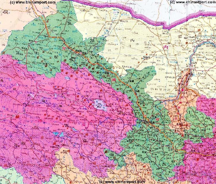
Tianshui & Area Maps
Wuwei (Simplified Chinese: ??) is one - no information available.
Go to www.drben.net webring
All Maps relevant to Jiuguan, Shaanxi Province
The China Report
The Tianshui Report is part of the overall website www.ChinaReport.com & www.drben.net
Learn about what is new on this Site from below window.
To Main Menu of All Websites at DrBen.Net
ChinaReport.com at
Please browse around the Town of Tianshui and wider Area using our Geographic & Historic Maps. Find out more about the City and Area through our many Photographic Reports on the main historic landmarks and Monuments and their rich history.
Alphabetically ordered list of Monuments, Landmarks in & around Town
Among the many landmarks of Wuwei City, the - no inforation available.
Tianshui Transport
Main Railroad Station of Wuwei - Photos and Introduction
Tianshui has one main railway station and no airport. The nearest airport can be found outside of Lanzhou, with a further small filed available at Jiayuguan. China National Highway 312 leads past Wuwei, East to Lanzhou and West past Zhangye, to JiuQuan, Jiayuguan, and Yumen and Anxi into neighboring Xinjiang-Uygur Autonomous Region.
Complete Listing of available Hotels in Wuwei, Gansu Province, China (PRC).
Qin Ling Mts
Hui
Sanguankou - Helan Pass Great Wall of China
Great Wall of China at GuYuan
Qiaowan
Jinchang
Yumen
Gantang
ZhongWei Great Wall of China (Ming Dynasty)
Nangchen
Songwei (=Zhongwei) (Ningxia Hui AR)
Yanchi
Delingha
Dachaidan
Chaka
Gonghe
Chaka, Qinghai Province
Huangyuan, Qinghai Province
Yugur
Bonan
Dongxiang
Aksay
Golmud
Tongren (Qinghai province)
XiaHe'
Pingliang
JiaYuGuan
Zhangye
Dunhuang
QingYang
Tianshui
Kong Tong Shan (2123 meters)
Wuwei
Yang Guan Pass - 1st Gate in the West - Han & Tang Dynasty
Bei Shan Range
JiaYuGuan Fortress & Suspended Arm Great Wall (Ming Dynasty)
Mogao Caves - Buddhist Holy Site & UNESCO Wolrd Cultural Heritage
Yu Men Gate & Toll House - Han & Tang Dynasty Great Wall
Labrang Monastery
BingLing Si - Buddhist Caves
Xumi Shan Buddhist Caves
JiuGuan
Xinjiang
AR
Xi'An , Capital of Shaanxi Province
JiaYuGuan
DunHuang
Republic of Mongolia
Ningxia
Shaanxi
Sichuan
Qinghai
Inner-Mongolia AR
Overview Map of Gansu Province and surrounding area's. Click for Full Sized Version.
TengGer  Desert
Helan Highlands
Ordos
Desert
Gobi Desert
Gobi Desert
Taklamakan Desert
Qinghai Plateaux
Ngoring Hu
<- Lop
Nur
Sichuan
Har Hu
Anxi River
Yellow River
LinXia
Gannan
DingXi
TianShui
BaoJi (Shaanxi Province)
PingLiang
QingYang
Wu'Du
XiaHe' + Labrang Monastery
JinChang
Anxi
LiuYuan
YaDan Land-forms
YingGuan Tunnel Entrance
Suo Guan Tunnel Entrance
JingTie Shan (5206 meters)
Qilian Shan (5564 meters)
Maji Shan - Buddhist Holy Mountain & UNESCO World Cultural Heritage Site
Sanwei Shan (2520 meters)
Liu Pan Shan (2928 meters)
Helan Shan (3556 meters)
Yinchuan, Capital of Ningxia Hui AR
WuHai (Inner Mongolia)
Alxa Youqi (Inner Mongolia)
Nanhua Shan
DingBian Great Wall of China (Ming Dynasty)
YongChang Great Wall of China (Ming Dynasty)
Bai Shan - White Mountain (Height 2013 Meters)
Xingxingxia (Xinjiang-Uygur AR)
Mazhong Shan
Mazhong Shan - Horses' Manes Mountain (2584 meters)
Gongpuquan (Pass)
Jiangjuntai
Qiaowan
Anxi
JiuGuan
Dingxi
Lanzhou
Lanzhou, Capital of Gansu Province
Gannan
Linxia
Xining
Xining, Capital of Qinghai Province
Wudu
Yinchuan
Xi'An
Wuhai
Zhangye
Yellow River
Bayan Har Mts
Golmud, Qinghai Province
Yellow River
Yellow River
Kazakh
Salar
Salar
Yugur
Tu
Tu
Menyuan, Qinghai Province, China (PRC).
Jiuquan Huangnibao Yugur Autonomous Township o/t Yugur Nationality, Gansu Province, China (PRC).
Tibetan
Mongol
Shizuishan, Ningxia Hui AR
Amnye Machen Mts
Heimaha, Qinghai Province
Gonghe, Qinghai Province
Darin, Qinghai Province
Darin
Dachaidan, Qinghai Province
Delingha, Qinghai Province
Tuosi
Lake
Dabuxun
Lake
Gandan (Gansu Province)
Yanchi (Ningxia Hui AR)
Diedu
Die'Du
Magu
MaGu
Jiuzhi (Qinghai province)
He'Nan (Qinghai province)
Xunhua (Qinghai province)
Huashixia, Qinghai Province
Madua, Qinghai Province
Madua
Qingshuihe, Qinghai Province
Xiawu, Qinghai Province
Nangchen, Qinghai Province
Longshi, Qinghai Province
Zaling
Lake
Xiawu
Yumen
Alxa Youqi
Ejin Qi
Ejin Qi (Inner Mongolia)
Aksay- Capital of Aksay Kazakh Autonomous County, Gansu Province, China (PRC).
Huixian
Tianshui Basic Knowledge

Location : Not Identified
Elevation : Roughly 1500 Meters, or 4600 Feet.
Surface Area (of County): 191,342 Sq kilometers.
Population: The Total Population of Tianshui City and its Prefecture - no information available.
Moon
Canyon
Click to go to Full Version Han Dynasty Empire & Connections Map !!
Today's Tianshui is an - no informaion available.
Everything about the Imperial Palace & the Last Two Dynasties !
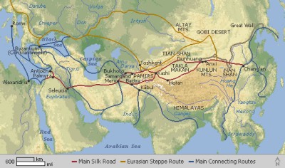
Map of China during the Rule of the Han Dynasty (206 BC - 221 AD) with the main trading roads of the Empire, the Silk Road and location of Huixian marked.
Huixian + County

View Larger Map
Huixian
Apart from being a hystorical Town along the Silk Road trajectory, near - no information available.
View the Land & Maritime Silk Road (of the Yuan Dynasty Era)
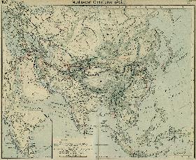
Map Trade Routes in Asia in the 13Th Century.
A Schematic Map of the Eurasian Trade Routes existing in the 13Th Century. Clearly marked in Red Accent on the Map are the cities of the network of land-bound trading routes through Central Asia known as the Silk Road (the path of Marco Polo and others).
You Tube Video - Eating a 'Jiuquan Hamir Watermelon' in the Desert.
WuWei
Guyuan, Ningxia Hui AR
Wuzhong, Ningxia Hui AR
A Full Google Earth Supported Map of Tianshui

View AsiaReport.com - Mastermap of Asia (entire). in a larger map
No information available.
Click Map Image to go to Full Version !
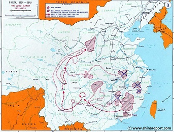
China Historic Map - Route Long March 1934/35 - 1A
A Schematic overview Map of the current Peoples Republic of China depicting the main route(s) of the epic Long March of 1934 and 1935.
Map clearly delineates PRC China current National borders and includes Provinces and Autonomous Regions, Main Cities and relevant Towns, initial Communist Soviets (Self-administered rebel areas), the routes followed by various elements among the Communist Groups and Armies, locations of important meetings points, main natural obstacles such as mountain ranges, the flow of large rivers such as the Yangtze  River and Yellow River, position of the Great Wall of China in Gansu Province, Ningxia Hui Autonomous Region, North Shaanxi Province etc, rough estimated routes of main railroads of the time and other details of interest.
Mouse over locations and link through for additional information on each location.
Tianshui & Area Hotels
Find DrBen and ChinaReport on Facebook with the latest from www.drben.net.
DrBen Nijhoff | Maak je eigen badge
Gansu Sources
Gansu Province
Baiyin Home
Gansu Province Home
China Offline Sources
AsiaReport.com Home
China Report Home
China Online Sources
China Online Store
China Maps
China
China Photo Galleries
China Report Club
Wuwei
Wuwei Home
Baiyin Prefecture
Zhangye
Zhangye Home
Tianshui
Tianshui Home
JiaYuGuan
JiaYuGuan Home
JiuQuan Prefecture
Aksay AC Home
Dunhuang City Home
JiuQuan Home
Dingxi Home
Dingxi Prefecture
Gannan Home
Gannan Prefecture
Lanzhou
Lanzhou Home
Huixian Home
Longnan Prefecture
Pingliang
Pingliang Home
Linxia (Hui) Prf.
Linxia Home
Qingyang
Qingyang Home
Jinchang
Jinchang Home
Gansu Economy
Gansu History
Gansu Monuments
Gansu Maps
Gansu Minorities
Yellow River in Gansu