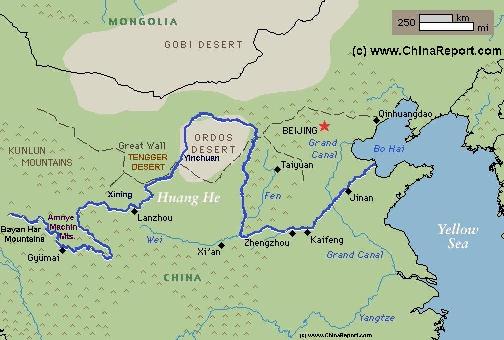
The Path of the Yellow River through China (2) Middle Reaches
The Yellow River is China's second longest river, measuring some 5464 kilometers (3,395 miles) in length. It is the world's 6th longest river.
The Yellow River is known in Chinese as Huang He and also as Huang Ho depending on spelling.
The drainage basin of the Yellow River, known as the Yellow River basin, is the third largest of all rivers in China (P.R.C.), encompassing a surface area of around 750,000 square kilometers (290,000 square miles)(official: 742,443 km² (290,520 mi²).
It extends 1900 kilometers (1.180 miles) from West to East and 1100 km (684 miles) from South to North.
The China Report
Introduction to the Yellow River (Huang He - 黃河) - China's 2nd largest River
ChinaReport.comat
Datong
Zhongwei
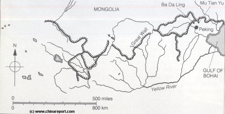
Schematic Map of the Flow Path of the Yellow River through China.
Click Map to go to FULL Version !
Upon reaching Gansu Province for the second time, the Yellow River meets what is known as the Central Chinese Loess Plateaux and the nature of the river changes dramatically. These are the middle reaches of the River. With waters still clear as crystal up on the Qinghai Plateaux, it is on the Loess Plateaux that the river acquires its famous Yellow Color, carrying millions of small dusty particles along on its stream. This is also the region where the river crosses the border from Tibet into China proper. In the valley's upstream from Lanzhou live various Tribal groups among whom Mongolians, Tibetans among whom rare Yugur. They are neighbored by a few Islamisized Tribes such as the Bonan and the mixed Chinese-Persian Hui.
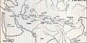
Map 1 of the Silk Road during the early Tang Dynasty Era. Clearly depicts the North & South Routes West of Dunhuang as well as the lost civilizations of Loulan and Hotan.
LANZHOU PREFECTURE AND LANZHOU CITY:
Having passed the historic borderzone with Tibet the Yellow River finally advances on the city of Lanzhou, the Capital of Gansu Province. It is particularly this section where it enters a zone that is subject to heavy industrial pollution.
Middle reaches of the Yellow River (2a) Yellow River in Gansu Province:
After springing from the rugged and remote regions between the Qaidam Pendi Shan and the Tangula Dangla Mountains that seperate Qinghai Province from Tibet Autonomous Region, the water from the yellow rivers many sources trickles slowly eastward through marches and meets the two lakes of Hyaring and Ngoring Hu, near Madoi in the region between the Amnye Machin Mountains and the Bayan Har Range in Eastern Qinghai Province. These are all lands inhabited in majority by the Tibetan Ethnic Minority and are regarded as parts of Tibet.
After flowing out of the Gyaring and Ngoring Lakes (Respectively re-dubbed Zhaling Lake and Eling Lake by the Chinese) situated in Madoi County of the Golog Tibetan Autonomous Prefecture (Qinghai) on what today is the border of Tibet Autonomous region (T.A.R.) and Qinghai Province the river is finally shaped into one, increasing in speed it thunders in a curve through South-East
Qinghai to flow along the edge of the Tibetan Plateaux on the border with Gansu Province in its south-westernmost corner.
The yellow river enters Gansu , then flows south of Awancang Town to the Sichuan Province Border from where it sweeps upward and northernly again to pass Xining, the capital of Qinghai (in East Tibet) before it returns to Gansu Province for a second spectacular pass through the Province.
LIUJIA GORGE - LIUJIA RESERVOIR AND YELLOW RIVER DAM:
In the past one of the most spectacular locations along the middle river in Gansu Province, notorious for its dangerous roaring and twirling waters caught between high cliffs, today the Liujia Gorge has been filled with the water held back behind the LiuJia Hydro-electric Dam which has formed the LiuJia Reservoir of the Yellow River. Constructed decades later than the first ″succesful″ Yellow River dam at Qingtong Gorge in Ningxia, the Liujia Gorge Hydro-electric dam was built in 1974 following roughly the same plan. At the time, it was the first high altitude hydro-electric dam built on the ″upstream″ sections of the river. As with the Qingtong Gorge Dam, the intention was mainly the (further) harnassing the powers of the river and the use its energy to drive Industrialization in the all important petro-chemical city of Lanzhou but a bit further downstream along the river. It was also the dam to bring electricity to the remote and disconnected towns and villages strewn around in the wider regions of the Gansu Province.
A total of 147-meter-high and with a length of 840 meters, the Liujia Gorge Reservoir allows for the storage of some 5.7 billion cubic meters of water in the LiuJia Reservor, the waters area of which cover some 130 square kilometers. The Liujia Gorge Hydroelectric Power Plant has a capacity of
1.2 million kw, and uses five gargantuan water turbogenerator units to generate 5.7 billion kwh of electricity into the regions and Lanzhou City each year.
Today, the creation of the Dam is usually presented as a ″water conservation″ plot and it has become a fairly popular tourist destination for tourist buses that traverse the area's. The lake is increasingly popular as a (remote) location for practicing various water sports (mainly boating due to the dangerous waters) and as a getaway for city dwellers from Lanzhou.
In addition to the Liujia Gorge Dam a secondary dam, the smaller Yanguoxia Dam (盐锅峡水电站 Yánguōxiá Shuǐdiànzhàn) has also been constructed on the Yellow River. It can be found downstream from the LiuJia Dam but also within Yongjing County (Of Linxia Hui).
DAXIA RIVER AND TAO RIVER:
The Yellow River's main tributaries within the prefecture are the Daxia River and the Tao River. They flow from the neighboring Gannan Tibetan Autonomous Prefecture (and the location of the historic Tibetan Monastery of Labrang), and fall into the Liujiaxia Reservoir from the southeast. The Tao River also serves as the border with the Dingxi prefecture-level city over some of its length.
In addition to its remote wilderness and according beauties as well as the Yellow River and its dams, the Yongjing County of the current day Linxia Hui Autonomous Prefecture is of particular interest because of the presence of remnants of the Great Wall of China in this region where it was built mainly along the gorges and valleys of the Yellow River.
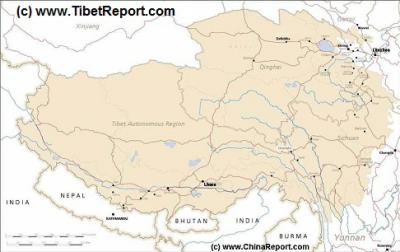
MapTibetHistoricalBorders
A Schematic Map of Historical Tibet, today Tibet Autonomous Region, Qinghai Province and a part of Sichuan province.
Included for reference are current International Borders, provincial borders, locations and names of main cities and towns, main rivers and lakes, mountains,importantTibetan-BuddhistMonasteries and other places of significance.
Further Reports link to More Photos and History & Backgrounds of each City, Town or Ethnic Community of Yugur, Dongxiang Tibetan, Lhoba, Kazakh, Mongol or others where available.
Today Tibet only exists as Tibet Autonomous Region of China. Tourist visits require an aditional visa !
Although not much, if any, information is available on the Great Wall of China in the Yellow River Gorges upstream from Lanzhou City, one thing is certain: it did exist.
As can be made out from adjacent map produced around the middle of the 20th century, the Great Wall of China was not as it is often represented on maps - merely a single layer wall - strung along someways
Long after the fall of the Tang Dynasty, the border wars and more minor raids had continued over the centuries. Up to the time when China became a Province of Mongolia (the Cathay Khanate) seeing the rise of the Yuan Dynasty (1271 AD - 1368 AD), many of the regions to the southwest along the arc of the Tibetan Plateaux had still been unified as the tribal Kingdom of Dali which held closer connections to Tibet than to the Chinese.
Although Dali was vanquished by the advancing Mongolians, it once more became a rebel base thereafter. For this reason a new wall was built in this location even as late as during the Ming Dynasty Era (1368 AD - 1644 AD). It is this Ming Era Great Wall of China section that was mapped later on, and of which remnants have been found later by scientists from the University of Lanzhou.
Since the existence of this section is confirmed by Lanzhou University, it must be counted as the first location where the Great Wall of China meets the Yellow River.
However, since regardless of our best efforts, so far the Yongjing County Great Wall cannot be traced on today's Google Map of the path of the Yellow River through the area and wider regions and since no one can give even an approximation of the location, the Yongjing County Great Wall of China is completely discounted and as yet, nothing much if anything, is published on it. The reasons for this may is also lie in the fact that the Yongjing County is then a physical proof of a (National) border with Tibet, a thing which may be classified as an incovenient truth.
No doubt to be classified as politically unwanted information, it is not entirely unexpected that nothing is heard about the subject whereas other sections of the famous Great Wall enjoy abundant high level scientific and also public attention. Generally speaking, public awareness of Great Wall locations is fairly high and the use of the internet has been improving available knowledge by the year. Not in the case of the Yongjing County Great Wall however.
BINGLING BUDDHIST CAVES:
As noted, before reaching the huge reservoir, the Yellow River passes the site of the remote UNESCO World Cultural Heritage Site of the Bingling Si, a renowned ancient complex of Buddhist Caves created over the span of some 16 centuries. Rightly world famous, the Bingling Caves are considered as among a string of Buddhist Cave complexes found throught the ancient Chinese heartlands along the Yellow River. By far the most famous ancient Buddhist Cave complex are the Mogao Caves, found near Dunhuang up the Hexi Corridor in the neck of Gansu Province. The other famous cave complexes are the Yungang Grottoes near Datong in Shanxi Province, the Longmen Caves near Luoyang in Henan Province, and the Leshan Giant Buddha of Leshan at some 110 kilometers from Chengdu City in Sichuan Province. There are however many more such complexes, especially in Gansu Province. Altogether these mark what may be regarded as the path of the Buddha, the trail of the advance of Buddhism into ancient China.
The Bingling Caves found their highpoint during the Tang Dynasty Era (618 AD / 907 AD) and due to what was until recently an ultra remote location its is counted as among the best preserved such cave complexes remaining today. Altogether there are 183 Niches and Statues to be found along both sides of the narrow bingling gorge of the Yellow River. Among the most renowned pieces are a 27 meter high statue of Maitreya (the future Buddha of Chinese Buddhism) and another 1500 year old Buddha Statue with a torn out (once golden) heart which sits across the Canyon from the Maitreya.
Adding to its remoteness, even today the Bingling Gorge can only be reached conveniently by taking an hour long boat ride across the Liujia (Xia) Reservoir, which makes it the only Buddhist Cave complex to have these specific conditions.
READ MORE IN: ″Bingling Caves Complex″.
Zhongwei
Yulin
Taiyuan
Xining
Lanzhou
Taklamakan Desert
Yu Men Pass
Datong
Luoyang
A Schematic Map of the Several Layers of the Great Wall of China defenses as they existed during the Ming Dynasty (1368 AD - 1644 AD) in Gansu, Qinghai, Ningxia, Shaanxi, Shanxi and Hebei Provinces. Map includes location of + link to Great Wall Passes as reported on by ChinaReport.com. Mouse over & Click Links for more Information and Photos.
Yang Guan Pass
Jia Yu Guan Pass
X
YanMen Guan Pass
Pian Guan Pass
Ordos Desert
TengGer Desert
Taklamakan Desert
Gobi Desert
Gobi Desert
Gobi Desert
Ngoring Hu
Wei River
XiAn
Hei River
Linfen River
Yellow River
Ejin Lake
due north of the important Silk Road node of Lanzhou, the city on the crossing point of the Yellow River with the trading pathways to the west. Lanzhou was of such importance to the connections in the western regions that it was protected by various layers and wall sections. It is known from observations done by early western explorers in the regions that at least one such section was built ″along″ the Yellow River, well upstream from the
city and in effect facing the Tibetan Plateaux and the very much independent Buddhist Kingdom of Tibet. As can be made out from the above Map, the city of Lanzhou sits at the bottom of a protective ring and sections of the Great Wall of China can be found upstream from the city along the Yellow River as well as downstream from it. In addition, significantly, another ring or curve of the Great Wall of China lay in a wide arc around the City of Xining, situated one step up on the ladder to the Tibetan Plateaux at a fairly short distance. Several reasons can be given for this regional defensive arrangement, but clearly the defenses did not only face towards the north, but also faced the Tibetan plateaux where the other hostile nomadic tribes, mainly Tibetans lived.
THE GREAT WALL OF CHINA SOUTH WEST OF LANZHOU IN YONGJING COUNTY:
A Full and complete Map of China (PRC) identifying all Language Areas big and small in all Provinces and Autonomous Regions of China.
Map includes Turkic Languages (Uygur, Kazakh, Kirghiz, Salar & Uzbek), Mongolian Language and Sub-Divisions (Mongol, Tu, Daur and Dongxian), Tungusic Peoples (Oroqen, Evenki and Xibe) and Languages, Korean, Tajik (Tadzhik), Mon-Khmer (Kawa + Puman (or Pulang)), Hui, Uygur (Uighur), Tibeto-Bhurman Languages, Tai and Miao, Yao and She' Language Area's and Borders. Main Area's and sub-divisions of Han Languages (Northern Mandarin, Eastern Mandarin, South-Western Mandarin and Cantonese) further included. This color-coded ethno-linguistic Map (of 1967 AD) identifies at a glance most ethnic minority regions in China
Map China Ethno-Linguistic / Language Distribution China
The Tibetans were essentially nomadic and much alike the neighboring Mongolians. Toughened by the climate and usually horse-born they had raided out from the heights of the Tibetan Plateaux at various times during the Tang Dynasty (618 AD - 907 AD) and threatened Chinese population centers. They even did more than that.
Although equally, time and again, the Han Chinese managed to get a foothold on the Tibetan Plateaux around the Qinghai Lake, building the city today known as Xining, the establishment of a foothold by no meant that the city was considered safe and invulnerable.
The second and longest pass of the Yellow River through Gansu Province starts at the village of DaheJia (Zhen) and the adjacent smaller village of Sibaozhi (Xiang) which lie just with the Linxia Hui Autonomous Prefecture (临夏回族自治州) due south-west of the city of Lanzhou. This is still a rather remote and also rugged region on the fringes of the Tibetan Plateaux where, during the wet season in Juli and August landslides are frequent. Situated on what is essentially to the rim of the Tibetan Plateaux, an special climatic zone known for its fertility and abundant wildlife, it is also a region with a very diverse multi ethnic population. As is further detailed below, the valley on both sides of the Yellow River is home to various tribes, among whom the Yugur - a small tribe rendered under the group of Tibetan Cultures, Dongxiang, the Hui, Tibetans, Salar and also the rare Bao'An people (also known as Bonan). Naturally, a lot of Han Chinese have also come to inhabit the regions more recently.
From the first villages on the border with Qinghai Province and Gansu Province the Huang He continues its pathway slowly flowing towards a section also known as the ″Three Gorges of the Yellow River″. Historically, the three gorges are the Bingling Gorge, the Liujia Gorge and the Yanguo Gorge.
The first gorge, Bingling Gorge is today well visited an highly appreciated for its ancient Buddhist Cave Complex filled with art and depictions from bygone era's. It lies upstream and west of the Liujia water Reservoir. The second gorge is today the most famous for the scene of modern man's achievement of taming the raw powers of the most dangerous gorge on the river. That is the LiuJia Gorge (LiuJiaXia) in the Yongjing County (永靖县) of Linxia Prefecture which with its 174 meter high wall of 800 meter length is an eye catching piece of modern architecture and equipment that is popular for a quick tourist stop off. The last and third gorge, is the Yanguo Gorge, which together with the nearby Bapan Gorge in the adjacent county was the first dam's to be built across the Yellow River in this region. Interestingly, the first damming projects were undertaken in the still controversial ″Great Leap Forward Era″ making a large impact on the livelihoods of the local population. Although little information can be uncovered on the subject so far, it was usual to make use of forced labor for the construction of such dams. Thus, it is likely that the Yanguo Dam is also a monument to the darker side of the Peoples Republic.
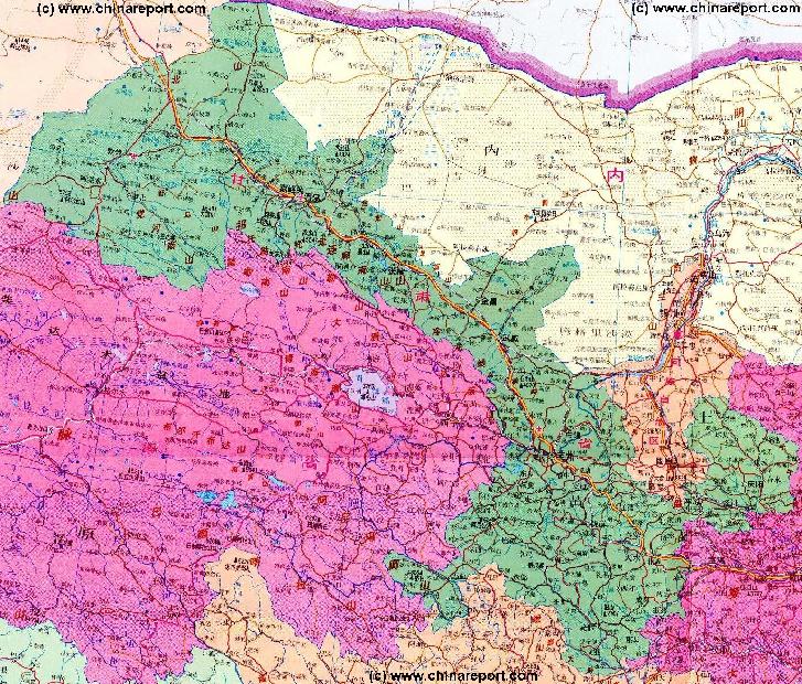
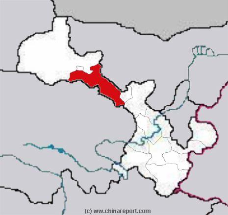
Schematic Map of Gansu Provinces showing the seperate Prefectures within the Province.