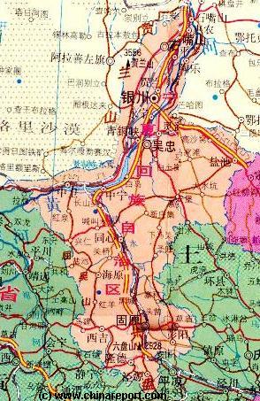
In Ningxia Hui Autonomous Region there are five sections of The Great Wall of China. Taken from East to West, the first of these is Yanchi County Great Wall of China. The others are Shuidonggou (水洞沟) (Coordinates: 38° 16′ 43.09″ North, 106° 31′ 53.45″ East), Dawukou (Shizuishan) also known as Jiucai Gou (Coordinates: 39° 4′ 7.97″ North, 106° 21′ 14.52″ East), Sanguankou as one of the passes in the Helan Mountains (Coordinates: 38° 20′ 48.72″ North, 105° 49′ 23.74″ East) and Songwei or Zhongwei (Coordinates: 37° 31′ 8.21″ North, 105° 10′ 54.41″ East). After Zhongwei the Great Wall continues across the border into Gansu Province where the first option to visit is the Gantang Great Wall of China site.
The Sanguan Great Wall can be found due South-West of Yinchuan, intersecting with the Provincial Road S102, before heading southward parallel to the Yellow River extending from the southern foothills of Helan Shan. The Sanguankou Wall is fairly long, starting a short way north of a Provincial Road S102 to Inner-Mongolia Autonomous Region, and stretching from there far past the Qingtongxia Hydro-Electric Dam to becoming intraceable north-west of Ertang Village (Ertang Cun). Originally, the wall connected all the way through to Zhongwei and the Zhongwei Great Wall in the south-west of Ningxia Hui Autonomous Region.
(4) Sanguankou (三关口) Three Gates Pass - General Introduction
This page was last updated: July 21, 2017
Great Wall of China in Ningxia Hui AR
ChinaReport.comat
The Great Wall of China at Sanguankou is located on the south end of Helan Mountains at only some 40 kilometers west of Yinchuan City. Its function is to guard a crucial lowlying pass leading from the Tengger Desert within Inner-Mongolia through the southern reaches of the Helan Mountains to the Fortress and city of Yinchuan, for over a 1000 years the main city of the region.
The current Great Wall of China at Sanguankou was built in the years between 1520 A.D. and 1531 A.D. when it was completed. Its name Three Gates Pass (San Guan Kou) refers to the presence of three layers of the Great Wall inside the Sanguan Pass, which includes a fortress. As was recently (re-)discovered, the 3rd and outer layer of the wall has not disappeared but was made up by a deep ditch, some 4 meters deep and 4 meters wide. It can still be found inside what is locally known as the Hongjinggou, the outermost part of the Sanguankou where it passes between two low mountains.
During the Ming Era toll was collected at the three gates (San Guan) from trading caravans traversing between Chinese and Mongolian lands.
The fame, or better, notoriety of the Sanguankou Pass along the Great Wall dates back over a 1000 years, to a time when -after the demise of the powerful Tang Dynasty (618 A.D. - 907 A.D.) in China - the Ningxia
A Full Google Earth Supported Map Overview of All Structures of the Great Wall of China from East to West, by DrBen.Net (c) ChinaReport.com and Google.com.
China Report - Map of the Great Wall during the Ming Dynasty
Satellite image of China and North-East Asia, with a super-imposed schematic Map of the location and Path of the Great Wall as constructed during the Reign of the Ming Dynasty. Included for reference are City names, geographical features of landscape, Names and locations of Passes on the Great Wall of China.
Today, a major highway runs through it at the pass, connecting Yinchuan city and Alashanzuoqi in Inner Mongolia.
Name:Yinchuan Ming Great Wall at Sanguankou (Sanguankou Ming Changcheng)
Inner Mongolia Autonomous Region Map 1A - Geographic Map
A Schematic Map overview of North & North-Eastern China's Inner Mongolia Autonomous Region entire, clearly delineating borders and including sections of all bordering Nations as well as bordering Chinese Provinces and Autonomous Regions of China.
Map and description include Main Cities and Towns, Main Monuments & Landmarks of Inner Mongolia AR and adjacent provinces & regions, the locations of the Great Wall of China inside the Map Area, major highways and road connections, provincial railroads and main railroad-stations, and main waterways, rivers and lakes of Inner Mongolia AR and wider region. This Map further provides links to on site photos and information on Cities, Main Monuments & Sights of Inner Mongolia.
Plain and adjoining regions enjoyed a brief period of national independence, creating what is known in the West as the Tangut Kingdom, and in China as the Xixia Period or Western Sunrise Period. It was during this time, the reign of the Tangut Kings, that Yinchuan first blossomed and prospered becoming rich from levies imposed on trade along the pathways of the Silk Road (See: "History of Ningxia Hui Autonomous Region", and "History of Yinchuan").
The end of this Great Period in the history of Ningxia and East Asia was brought on by none less than Genghis Khan, who in 1209 A.D. defeated the Tanguts out in the Tengger desert, leading his troops through the Sanguan Pass and onto Yinchuan in order to subdue the wealthy Tangut neighbors.
Thereafter, the Tangut, although resisting and fighting on until the year 1227 A.D. when Yinchuan was largely destroyed by another Mongol incursion, would be absorbed into the larger Mongolian Empire, leaving the memory of the low lying pass south-west of Yinchuan as a pass of doom. It had proven to be a dangerous gap in the natural defenses provided by the Helan Mountains.
Although the Tanguts (Xi Xia) would never rise again, their culture lost in time, when over a century later the Han Chinese managed to drive the Mongolians out of their realm and back to the plains of Inner-Mongolia lying beyond Ningxia, the lessons of that fateful year 1209 A.D. were still remembered. As they soldiers of the rising Ming Dynasty (1368 A.D. - 1644 A.D.) could clearly still tell from the ruined remains of the once mighty city and its King's Mausoleums (likely destroyed in 1227 A.D. ; see also: "Shuidonggou Great Wall of China" and Khara-Koto (Heicheng ; Black City)), a failure to defend the passes in the Helan Mountains could have disastrous results. The defense of the Pass by means of a fortress only, as was done previously, had not sufficed. Hence, the Great Wall of China was added and built across the mountain pass in the early 16Th Century.
Today the Sanguan Pass Great Wall is a well-eroded mud wall with relatively few features. At best it measures one to two meters high in its standing parts, with better preserved remains in the pass itself. The current pass knows two layers of the Great Wall, the main layer following the line of the Helan Mountains, with a second layer built further East in the hills lying beyond the main gap of the pass.
The third layer of the wall consists of only a ditch, not a wall, which is found in the west on the outside of the Pass. A line of Beacon Towers can be found along the S102 Provincial Road pointing in the direction of the main garrison at Yinchuan.
With Yinchuan growingly popular as a tourist destination in a developing China, more and more tourists come to find the Great Wall. The most popular section for mass tourism today is still the Helan Kou, cutting further north through the Helan Mountains with its associated Qing Dynasty Era (1644 A.D. - 1911 A.D.) Pacify the North Fortress (Castle) (Zhenbei Bao) turned into Film Studios. These are known throughout China today as ZhenbeiBao better known as the Western Film Studios.
The next popular section has become Shuidonggou Great Wall situated due East of Yinchuan, due to its associated stone age relic site and the much exploited Red Mountain "secret" Fortress of the Great Wall. Not too many tour groups visit the Sanguan gou, although there is always some traffic of visitors.
The Sanguan Pass is situated on the border between Yongning County of Yinchuan City Prefecture in Ningxia Hui Autonomous Region and the Bayan Nur Prefecture of Inner Mongolia Autonomous Region and in ancient times formed the border between Chinese held territory and lands at least nominally belonging to nomadic tribes of Mongolian origins. Although National borders have shifted since and Inner Mongolia has been incorporated into the Peoples Republic of China, by and large the pass still marks the border between the irrigation agriculture and urbanized living of the mainstream Chinese and the more barren lands beyond. The lands situated outside of the three gates pass are considered parts of the Tengger (or Tenggeli) Desert, which today should be considered more deadly than in the great blossoming days of the Silk Road or during the Mongolian conquests that set the stage for the rise of the Mongolian EurAsian Empire (and included for the first time the lands on both sides of the Helan Mountains).
SANGUANGOU ROAD DIRECTIONS:
Read all details on how to reach the Chimukou, now Three Gates Pass (San Guan Kou) by road in: