Train Travel and Railroad Connections within Inner-Mongolia Autonomous Region :
Main Cities & Population Centers of Inner Mongolia Autonomous Region :
History of Inner Mongolia :
Transportation & Travel connections Inner Mongolia Autonomous Region :
Economy of Inner Mongolia Autonomous Region :
Ethnic Minorities of Inner Mongolia
This page was last updated on: June 22, 2017
Inner-Mongolia is the third largest of China's Five Autonomous Regions and the third largest territory within the Peoples Republic of China. In total, it comprises about 12% of the total landmass of the country.
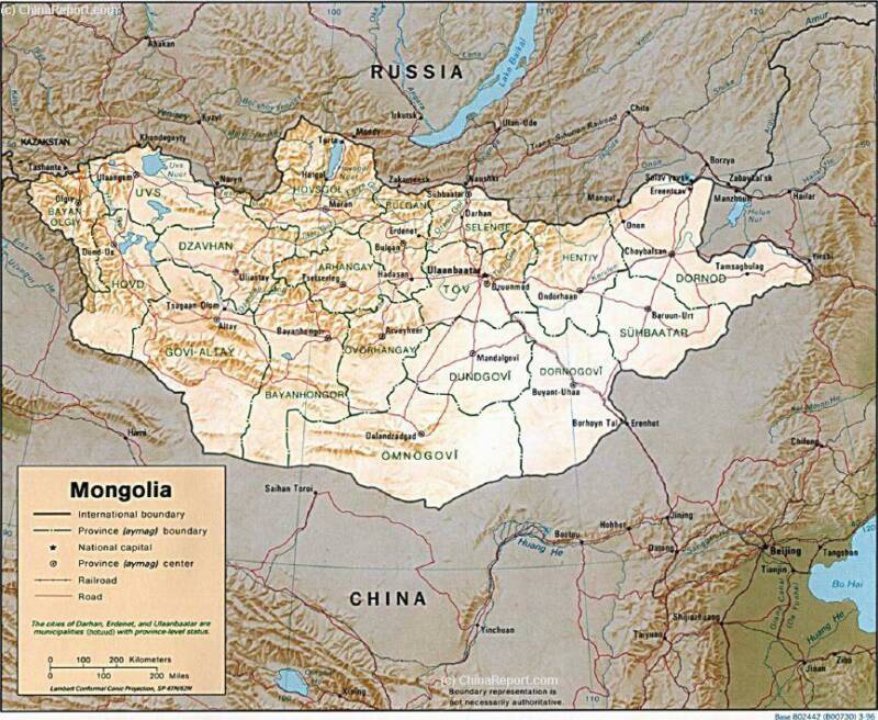
Inner Mongolia Autonomous Region lies in the upper North and North-East of the country, straddling the border with The Republic of Mongolia and The Russian Federation. Spanning some 2.900 kilometers (1,800 Mi.) from West to East, Inner Mongolia is a very large and key territory within the Peoples Republic of China, bordering and neighboring no less than 8 Provinces of China. These
Introduction to Inner Mongolia (内蒙古 ; Öbür mongγol) Autonomous Region
Highlights, Monuments and Scenic sites of Inner Mongolia
China Report - Map of the Great Wall during the Ming Dynasty
Satellite image of China and North-East Asia, with a super-imposed schematic Map of the location and Path of the Great Wall as constructed during the Reign of the Ming Dynasty. Included for reference are City names, geographical features of landscape, Names and locations of Passes on the Great Wall of China.
Capital of Inner Mongolia Autonomous Region - Hohhot
Population - 23,970.000 Million (2007 Estimate) and rising. Up from 20 million 67.000 in 1987 and an estimated 23 million 790,000 in 2002. Most of the population growth is caused by immigration of Han settlers to the Cities and new factories of the Inner Mongolia Autonomous Region.
Main Rivers and Waterways of Inner Mongolia Autonomous Region :
Source Book
"North China Front"
( No longer available )
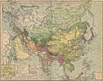
A Full and complete Map of China (PRC) identifying all Language Areas big and small in all Provinces and Autonomous Regions of China.
Map includes Turkic Languages (Uygur, Kazakh, Kirghiz, Salar & Uzbek), Mongolian Language and Sub-Divisions (Mongol, Tu, Daur and Dongxian), Tungusic Peoples (Oroqen, Evenki and Xibe) and Languages, Korean, Tajik (Tadzhik), Mon-Khmer (Kawa + Puman (or Pulang)), Hui, Uygur (Uighur), Tibeto-Bhurman Languages, Tai and Miao, Yao and She' Language Area's and Borders. Main Area's and sub-divisions of Han Languages (Northern Mandarin, Eastern Mandarin, South-Western Mandarin and Cantonese) further included. This color-coded ethno-linguistic Map (of 1967 AD) identifies at a glance most ethnic minority regions in China
Map China Ethno-Linguistic / Language Distribution China
new roads and infra-structure and so transforming under pressure from Chinese Industries moving into the region. Traditional nomadic lifestyles, already under severe threat from the desertification and larger climatic changes are pushed to the brink of extinction by the influx of a new and modern way of life. Culturally part of Mongolia more than China, and torn between two economically rising nations, the territory remains in flux.
Geographically speaking Inner Mongolia does not merely consist of endless grasslands, but knows at least 4 very distinct landscapes and regions. On the largest scale these are identified as: first the forested, hilly and swampy Hulunbuir region in north-east China's Manchuria, secondly of the mountainous Da Hinggan Region, thirdly of the Manchurian Plains and steppes of Xilin Gol and Ulanqab Leagues in the East and center, and as a fourth the huge expanses of the Gobi Desert and associated
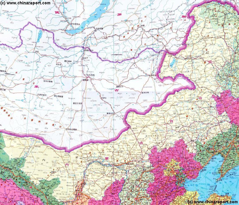
Full Map of Inner Mongolia Autonomous Region and adjoining territories, including 8 Provinces of China.
The For all information regarding rivers, lakes and waterways within all Prefectures of Inner Mongolia Autonomous Region please refer to:
As is vividly demonstrated by the adjacent satellite night image of Eastern Asia, most of Mongolia and large parts of Inner Mongolia remain sparsely populated. Although new roads have been constructed, local environments do not sustain large populations.
Historically, towns and later cities have been founded along rivers and lakes along which led ancient trading routes and trails. Industrial cities of today's Inner Mongolia Autonomous Region are found along the Yellow River.
The Largest City in Inner Mongolia Autonomous Region is the industrial city of Baotou, founded along the Yellow River after the establishment of the Peoples Republic of China and the completion of the Baolan Railway. Next in size is the administrative Capital of the Inner Mongolia Autonomous Region,
Satellite Image Overview of Eastern Asia at Night. Clearly identifyable are the black gaps formed by the Tibetan Plateaux and Taklamakan Desert on the left, and Mongolia and Inner Mongolia in the Top Center. As can be seen, the main modern population centers in Inner Mongolia lie in a string along the Yellow River. As a comparison, only nations such as North Korea and mountainous Tajikistan are similarly dark.
Other population centers of considerable size are the city of Wuhai - an industrial center on the Yellow River just north of the Ningxia AR border, Chifeng and Tongliao, all three of which are organized as City Prefectures of Inner Mongolia AR.
It should be noted that the city of Jiagedagi in the far North-East is NOT a part of Inner Mongolia in an administrative sense. Technically, it is under jurisdiction and administration of Heilongjiang Province but ethnically and culturally it is part of Mongolia and Inner Mongolia.
Due mainly to the harsh climatic zones, deserts and other environmental and natural bariers, until fairly recently, Inner Mongolia was the among the most under-developed regions in the Peoples Republic of China entire. On par with far flung western regions in Xinjiang-Uyghur Autonomous Region and the impassable heights of the Tibetan plateaux, Inner Mongolia was a very poor and sparsely populated region until at least the 2nd half of the 20Th Century. Until the advent of the Peoples Republic of China in 1949 AD, sparsely any economic development beyond the lifestyle of the nomadic herdsmen that dominated large swaths of the territory had been made.
In the first half of the 20Th century some paved roads were constructed. Among the earliest roads through Inner Mongolia was the American sponsored Stillwell Road. Later, development of railways reached explorable parts of the Inner Mongolian territories starting in some sense, a modern age in these parts.
The Dominant Ethnic group within Inner Mongolia are the Han people.
In turn, the largest ethnic minority group are made up by the various tribes of Eastern and Western Mongolians, who were in the past known as the Kalkhas and the Oirats. Traditionally, the Kalkhas occupied most of Western Mongolia and parts of Xinjiang and Tibet, whereas the Oirats lived exclusively in the East. Through mutual bickering and battles they stay culturally and geographically sperate.
Today, these distinctions are far less useful, and all Mongolians are basicly huddled together as being of one ethnicity and one people. In total there are over 8 million Mongolians living withing Chines borders. They are a very important and large group, who of late have been re-asserting themselves. Inspired by a rising tide of National Pride in Mongolia, which has a booming economy based on the mining industry, and frustrated with their perceived marginalization and lack of autonomy within China, in the year 2011 a situation of unease persist throughout Inner Mongolia. Starting on May 26Th of 2011, clashes between Mongolian youth and local Government and Police have occurred in Xilin Hot and other population centers. According to sources among which the New York Times, students of Hohhot Nationality University were locked inside their gates for five days or more to prevent them from taking to the streets, mass arrests have occured and internet access from the region has been severly restricted.
On a national scale (P.R.C.) Mongolians comprise around 8 % of the population. Within the Inner Mongolia Autonomous Region the percentage of ethnic Mongolians in the population is roughly 20%.
Although their numbers dwarf in comparison to the two main ethnic groups, there are however a significant number of other ethnic minorities to be found within Inner Mongolia. There are 10 in total, including the Oroqen, the Evenki (Ewenki), the Xibe, The Morin Dawa Daur (situated near Morin Dawa their homeland), the Manchu's (Nuzhen), Russians (Eluosi) and even Chaoxian (Koreans).
Source Book
"The Tea Road"
( No longer vailable )
Within the large Inner Mongolia Autonomous Region, landmarks and monuments are few, and often enormous distances lie between special destinations and scenic sites. Until fairly recently sparsely populated and the domain of nomadic tribes, compared to other parts of the Peoples Republic of China there are few historic sites to be found. The few historic Monasteries that were dispersed throughout Inner Mongolia and Mongolia were sadly destroyed during the Communist Era. As a result, tourism and travel within Inner Mongolia is mainly about the wide and varying landscapes; the Gobi Desert, the Steppes and the Lakes and Marshes, and of course - the traditional culture and lifestyle of the Mongolian Nomadic Tribes.
As described, in practice, the Inner Mongolia Autonomous Region can be divided into at least 5 geographically and climatically distinct zones, which helps when trying to get an understanding on which kind of attraction can be found in which region. Eventhough traditionally Inner Mongolia was thinly populated and few historic buildings were ever erected on its plains and in its few towns, the list of Landmarks, Monuments and Scenic sites within the huge Inner Mongolia Autonomous is very long. They are therefor listed in their very own section of the CHina Report Chapter on Inner Mongolia Autonomous Region. For general information, please refer to:
(This Page also serves as an Index Page which links to all Pages on the Landmarks and Monuments of each individual Prefecture or League)
To review all landmarks, monuments, scenic sites and special locations within the Inner Mongolia AR they are best taken administrative division, meaning they are reviewed below by Region and location. For a listing of Landmarks within each specific Prefecture or Region of the Inner Mongolia Autonomous Region, please refer to the sub-sections on each individual Prefecture.
Due mainly to the large size of the Inner Mongolia Autonomous Region comprising roughly 12% of the total landmass of The Peoples Republic of China, its dramatically varying landscapes and environments, as well as the previously under-developed nature of large parts of the region, transporatation and travel within Inner Mongolia can be arduous and complicated. Most cities and main population centers are however reachable by road, railroad and lately some by airplane.
With most of it consisting of desert and semi-desert grasslands, traditionally the main thoroughfare for transport in Western Inner Mongolia was the Yellow River, which was passable for barges between Baotou and Zhongwei as far upstream as the Qintongxia Gorge.
Other parts of the the wilderness of Inner and Outer Mongolia were only traversed by the main pathways of trading routes running south to north from China into Mongolia. Further, in the 19th and early 20th century only small roads existed here and there, the more roads the closer to civilization and the Chinese Han settlements. The wildest parts of Inner Mongolia lay in the wooded and mountainous north and in the west was the desert realm of the Ordos and the Gobi Desert.
There were no railroads within Inner Mongolia until well into the 20Th Century, the turning point coming with the building of the communist Peoples Republic of China.
With large parts of the territory undeveloped until recently, Inner Mongolia offers an abundance of wildlife and remote places to reconnoiter. To give an idea, the region offers some 880.000 square kilometers of grassland which ranks it number one grass territory within China. Furthermore, mainly in the North and North-East, there are a 160.000 square kilometers of forested ground, the second largest forested area in the Peoples Republic and in total Inner Mongolia counts up to 7000 square kilometers of fresh water surface area, lakes and rivers.
Thus, Travel into Inner Mongolia is usually held synonymous with adventure and the great outdoors. The most popular pastimes for visitors, a horse-ride on the wild and wide Mongolian steppes, a Camel ride in the sandy expanses of the desert, or better yet: traditional Mongolian ice-fishing for those who dare come and visit in the winter months.
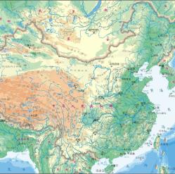
Map of China and Bordering Nations of Asia - Detailed Topographical View
A Geographical overview Map of China and neighboring Nations of Central, East and South-East Asia with National Borders and Capitals. Nations are Vietnam, Laos, Myanmar (Burma), Bhutan, Sikkim, Nepal, India, parts of Pakistan, parts of Afghanistan, Tajikistan, parts of Kyrgystan, parts of Kazakhstan, Eastern parts of Russia (Russian Federation), Republic of Mongolia, North Korea, South Korea, a small part of Japan, and further the South-East Asian Nations of the Philippines, Vietnam, Laos, Cambodia, MyanMar (Burma) and Bangladesh.
In history, Inner Mongolia has been a part of Mongolian (tribal) Territory - a nation which spawned the largest Empire in world history; the Mongolian Empire, as well as Part of the Qing Dynasty Empire (1644 AD - 1911 AD) of China. For most of known history they were sparsely traveled regions, considered inhabited by exotic barbarian tribes living outside of true civilization.
Although previously barbaric and hedon, in recent centuries the nomadic population of the regions were overwhelmingly Buddhist and many Buddhist Monasteries and Temples were spread throughout the territory.
After the founding of The Peoples Republic of China in 1949 AD, the territory making up Inner Mongolia today, remained a collection of ill defined and disputed territories situated geographically between the Republic of Mongolia (heavily under Russian (Soviet Union) Influence at the time) and the heartland of Chinese (Han) Civilization within the Provinces of the Peoples Republic of China.
Although inhabited by Mongolian Tribes, it had been predominantly under Chinese political control and influence until after the fall of the Qing Dynasty in 1911 AD. Thus, the Chinese Communist Party considered it an essential and strategic part of China, rather than a integral part of Mongolia or even the Soviet Union (C.C.C.P.).
Originally founded in 1947 AD in the North-Eastern regions of China (Hulunbuir) only, it was eventually expanded westward to include essentially (almost) all Mongolian Ethnic (minority) Communities set along the border with the Republic of Mongolia.
A its name suggests, Inner Mongolia Autonomous Region is officially the main home and base of the Mongolian Ethnic Minority Community within China, and so in the eyes of today's Foreign visitors and Tourist, the Inner Mongolia Autonomous Region is mainly associated with either the vast open grasslands and the nomadic lifestyle of the traditionally nomadic Mongolian Population, or with the wide and dangerous expanses and landscapes of the Gobi Desert. Many travel to parts of Inner-Mongolia to get a chance to explore the impressive landscapes, ride horses on the plains and spend a few nights in a Mongolian Ger (tent) enjoying some of the traditional Mongolian way of Life. Various corners of Inner Mongolia are renowned for their natural beauties, silk road associated history and also exotic ethnic groups and extra-ordinary wild life, the latter always under threat from climate change and advancing civilizations. Under-highlighted treasures of Inner Mongolia include sections of the first ever constructed Great Wall of China, erected during the Qi'In Dynasty (221 BC - 206 BC).
In the last decade and ongoing, the regions have seen a vast expansion of the Mining Industry as China is looking for coal and other resources to fuel its still rapidly expanding economy. The otherwise remote, sparsely populated and beforehand undeveloped regions are now unlocked by
Schematic Overview Map North China, Inner Mongolia and Mongolia :
Taken from West to East, the first main road in Inner Mongolia are the road from Datong in Shanxi Province in the South to Ehrenhot -border town with Mongolia- in the North and from there on to the Mongolian Capital of Ulaanbataar (Republic of Mongolia). In history it was the main camel caravan and trading route from the Chinese Capital into Mongolian territories, trading among things tea, silk, ceramics, metal items and other sophisticated Chinese products for animal skins, herbs, salt and other goods. Today this is the National Highway G208.
The second historical road from Han Territory into the Mongolian lands beyond the Great Wall of China and vice versa lies only slightly to the East. It leads from the Capital of Beijing to Zhangjiakou in Hebei Province, better known as Kalgan (in Mongolian language). From Kalgan it leads northward through a 27 kilometer long mountain gorge towards the mongolian steppe plateaux and traditional Mongolian Tribal lands.
Interestingly, Zhangjiakou was for centuries a military bastion and stronghold in support of The Great Wall of China and the gorge was the invasion route chosen by invading Mongol Armies in the 12Th Century.
Today the road through Zhangjiakou (Kalgan) is an important highway thoroughfare for coal and ore trucks hauling the mineral wealth of Inner Mongolia and Mongolia down to Chinese factories for fuel and raw materials. Once the domain of camel caravans it is now the G207 national highway notoriously clogged with 1000's of dusty dump trucks.
Follow the road from Beijing to Zhangjiakou, either to head north-west and join up with G208 (Datong-Ehrenhot) through Jining, or head north and north-east along G207 to reach the city of Xilin Hot in the heart of the
Schematic geographic overview of North China, most of Inner-Mongolia, the Republic of Mongolia and relevant parts of the Russian Federation. Clearly, the main traffic artery to Mongolia leads from Beijing (Hebei Province) or Taiyuan and Datong (Shanxi Province). In Manchuria, the North-East, further connections lead to the Mongolian Capital of Ulaanbataar, or directly into Russian territory. As shown, large parts of Inner Mongolia have no large towns nor roads.
Due to the presence of the Gobi Desert to the North, the highway G207 and road ends at Xilin Hot. From Xilin Hot, further provincial roads lead in two directions. The first east to Ehrenhot (S101, followed by S309), or the other to bend north-west and curve through an ancient lake and marsh region populated with Mongolians and then back south to the City of Tongliao an throughly Chinese City in the Manchurian Plain of south-east Inner Mongolia.
A third road from Chinese territories into Inner Mongolia and beyond runs in the North-East, traversing the narrow neck that distinguishes the Xilin Gol League from the Da Hinggan League.
In history, this was the main throughfare between the Manchurian Capital of Shenyang, once the base of the emerging Qing Dynasty (1644 AD - 1911AD) , and the lands of their important allies and vasals, the Mongolians. In the 16Th century, the previously nomadic Manchu tribes emerged from Manchuria but captured much of Mongolia before taking the throne over the Han Chinese. Naturally, there was an important and well used road between their Capitals.
Today this historic route is mainly represented by the main highway G203 leading North-East out of Shenyang in Liaoning Province to head directly the city of Songyuan in Jilin Province, near Chagan Lake and along the Songhua River. This now large industrial City is situated on the border of Mongolian and other traditional tribal area's (and along the Manchurian Railway). From Songyuan the ancient route turns into National Higway G302 which runs through the Kerqin Grasslands to the City of Baicheng (Chaghanhot, which also means "white town") which today is a stronghold of Mongolian and other ethnic groups.
From Baicheng the main road reaches as far as Ulan Hot (Hinggan), the Capital of Da Hinggan League in Inner Mongolia. Although the ancient road to Mongolia continues from Ulan Hot through the Greater Hinggan Mountains to the town of Alxan, this is a minor provincial road through mountainous, wooded and sparsely populated regions. Eventually, beyond Alxan the roads are even smaller and must curve north-west around the impassable Numrug Reserve and the Buir Nur (Lake) of Inner Mongolia to head in the western direction and reach Choibalsan in the Republic of Mongolia. Few however do. The region is mainly known for its extensive horizonwide grasslands, remote tribal villages and long abandoned border region.
Few Roads within Inner Mongolia go north of Hinggan (Ulan Hot). In this far North-Western Region of China there are no historic roads or main trading routes. Before, there was only wilderness, mostly large forested regions inhabited by hunting and fishing tribes, some trading posts, and the traffic arteries of the regions were rivers and forest pathways leading down to Chinese trading settlements. Specifically the Norther tip of Inner Mongolia and the adjacent regions of Heilongjiang Province are notorious for their swampy and boggy grounds, often forming natural borders that later turned into the international borders of today.
Today the transportation situation in these remotest of regions is dramatically improved by two national highways, the G111 and the latest addition, the G301 National Highway leading to Hailar (Hulunbuir), the now unlocked Capital of Hulunbuir League which makes up the northernmost parts of Inner Mongolia. Hardly anyone travels to these parts, not many Chinese, let alone foreign travelers.
As a general note: main airports within Inner Mongolia AR are reachable via Beijing Capital International Airport, Shanghai, and other large cities. Distribution to smaller local fields goes via Hohhot, the Capital of the Autonomous Region and Baotou.
The main airports within West- and Central- Inner Mongolia are Wuhai, Baotou and of course the Capital Hohhot. Recently the Ordos City Prefecture also developed its own National Airport near the administrative Capital of Dongsheng (东胜区). Reach dongsheng via Hohhot or Baotou, but also via regional airports such as Yinchuan in Ningxia Hui Autonomous Region and Yulin (Regional) Airport in North Shaanxi Province. Other options may be available !
For full details read the Chapter: Transportation in Inner Mongolia Autonomous Region.
Flights connections, Air travel and airports within Inner Mongolia AR :
Main roads and highways within Inner Mongolia Autonomous Region :
Since their advent in China in the early years of the 20Th Century, trains have been the main mode of transportation in China, both for goods as for people. And things will likely remain that way, regardless the large expansion of airports and airtravel within China. From those early years on, a large railway network was strung across (mainly) the central regions of China serving industrial, military and other functions. However, outlying regions, mainly sparsely inhabited border regions with little commercial value remained unconnected.
As for Inner Mongolia, By the end of the reign of the Qing Dynasty (1644 AD - 1911 AD) there were no railroads in the entire region. The only railroads then available ran to the coal mines of norther Shanxi Province, from where travel into Inner Mongolia was on foot or camel or horseback.
Far to the North however, the Trans-Siberian Railway, a now renowned train route was constructed between 1891 AD and 1916 AD, connecting Irkutsk, Ulan-Ude, Chita and Khabarovsk to Vladivostok on the Sea of Japan. Later, a branch of Trans-Siberian Railway would be connected to Shenyang in Manchuria, creating the branch line of the Manchurian Railway which did not run through North-East Inner Mongolia but through traditional Han Chinese territory.
In other words, one could only reach the borders of Inner Mongolia by train. But, that was it.
This situation essentially only changed with the further industrial development of China, which occured after the establishment of The Peoples Republic of China in 1949 AD.
A newly arising a modernizing, non feudal China would have to be an industrial state, so everyone agreed within the top ranks of the leading Communist Party. Thus throughout the 1950's, China embarked on massive and perhaps overzealous effort to build factories across the Nation, creating, jobs, fueling the economy and creating a need for materials. As a result, Inner Mongolia, beforehand considered mostly a buffer region with the (unfriendly) Russian neighbors (as it had been for centuries) suddenly became a region of vital economic resources. Suddenly, a grand scheme was hatched for the development of (worthwhile) regions of Inner Mongolian territories, mostly resulting in railroads to connect with the coal and Iron resources found there.
Only later direct links with other cities in Inner Mongolia and beyond to Ulaanbataar and Irkutsk became available.
Considering this brief history, the current railroad network in Inner Mongolia, especially the routes of main lines are easier understood.
Expanding upon the then existing railroad network, and based upon historic trade routes with the northern neighbors, new railway lines were drawn in the 1950's and 60's. The first railway projects were considered vital economic projects, meaning they had to extend to the mineral riches of the Gobi Desert of (mainly) central Inner Mongolia. There were military considerations as well.
Thus, the railway that already connected Beijing and the rest of China to the Capital of Shanxi Province at Taiyuan, was extended northward to reach into Inner Mongolia via Datong and then Jining providing a first railroad into Inner Mongolia. Even today, this is an important railroad, connect from China's Capital, via Datong to Hohhot, the Capital of Inner Mongolia.
Based upon this first branch, further connections became possible.
Still full of zeal and enthusiasm from what seemed to be the succesful resurrection of a fully independent China, Chinese across the nation embarked on projects which had previously seemed impossible or too expense to try. Among these was an ambitious project which proposed to build a railroad across the Gobi Desert, connecting Hohhot and Baotou, the end of the railway in Inner Mongolia, with the Grain Fields of Ningxia and the emerging Industrial, military and logistic Capital of the West and ancient Silk Road city, Lanzhou. (At the same time, another project, entirely secret, was launched to construct nuclear facilities in both Baotou and Lanzhou, cities situated along the important new railway line.)
Between 1953 and 1958 construction progressed, leading to the opening of a new project of National Pride, the so-called Baolan Railway. The Baolan Railway, still a major backbone of railroad network in Inner Mongolia follows the Yellow River upstream from the heavy industrial city of Baotou, providing an alternative and more efficient transport link for goods (coal, iron, minerals, ore) up and down the River and beyond the otherwise impassable desert.
Noteably, it was also the first ever railroad connection transporting Chinese people across the width of Inner-Mongolia. Many would soon go, starting a process of Han migration into Inner Mongolia that is still ongoing today. Today the Baolan Railroad remains the only railroad traversing the Western expanses of Inner-Mongolia.
The next important, and historically second railroad connection within the large Inner-Mongolia Autonomous Region matches the historic Silk- and Tea- northern trade route into Mongolia and Russia.
Historically based upon a Gentlemans agreement between the Russian and Chinese Courts, this route leads from the Chinese Capital of Beijing, via several available passes of The Great Wall of China into Inner-Mongolia and via the ancient trading post of Ehrenhot on to Ulaanbataar in Mongolia.
From Jining, the line extends directly north to extend across Inner Mongolia to the border at Ehrenhot and beyond to Ulaanbataar.
Importantly this section is the main railroad artery within Central Inner-Mongolia (Hohhot and Ulanqab Prefectures). Furthermore, having been connected from Ulaanbataar to the Russian City of Irkutsk on the Trans-Siberian railway, it is now an important international train route. Considered a main branch line in these parts, its provides the only link with Civilization for many on the Steppes of Mongolia and far flung regions beyond. Withouth the railway line, there would be no towns of the steppes. The line also served vital military functions, especially in the time of the Soviet Union (C.C.C.P.) when the railway line served as the main strategic backup for frontier military bases and the 1 million Russian troops and tanks deployed on the Chinese border in the 1960's and 70's.
Other main railroad lines within Inner Mongolia run far further to the East, again following the traditional trade routes that had already lasted over the previous millenium. This means that in the Far eastern Manchurian regions, the industrial city of Shenyang (historically: Mukden), already an important center on the Manchurian Railway (north to south branch line of the Great Trans-Siberian Railway) was further connected to Tongliao in Inner-Mongolia and Baicheng (Changanhot) in Jilin Province. Initially this provided a railroad connection from the emerging heavy Industrial Centers of the Manchurian plains along the Manchurian railway, with the raw materials needed found just beyond in the previously under-developed regions of Xilin Gol League and Da Hinggan League of Inner-Mongolia.
Only later this line was extened to lead to Hailar, a previously cut of tribal City in the grassy and forested expanses of Hulunbuir, Inner Mongolia's wildest region. Today these railroads form the main frame of the railroad network within North-Eastern parts of Inner-Mongolia.
The fourth main railway line within Inner-Mongolia should be considered the line from Qiqaha'er westwards to Hailar and from there to Chita in the Russian Federation.
Based upon the Manchurian Railway line itself, which travels from Shenyang directly north to pass through Changchun - Capital of Jilin Province, and Harbin - Capital of Heilongjiang Province to Vladivostok on the Sea of Japan, the line Qiqaha'er to Hailar and through to Chita is considered the second mian branch line of the Trans-Siberian Railway to emerge after the historic Manchurian Railway, and is thus the last pillar of the Inner Mongolian Railroad network. All other railroads are based upon these, connecting various crucial population centers and towns within the large expanses of its territory.
Read Full Details on Train Transportation in Inner Mongolia in the Section: 'Transportation in Inner Mongolia AR', or check the cities of your route for information on local railroad lines, train stations and service.
Today's transportation network within Inner Mongolia still very much reflects these bygone days. That is, there are but a few roads spanning the gap between Chinese Civilization, the Mongolian Territories and The Russian Federation beyond.
Last but not least should be noted the ever present Hui islamic ethnic group, who have large settlements within the south-west of Inner Mongolia but have spread throughout the territory. Having only two historical landmarks in the capital Hohhot , one is a Buddhist Temple, the second a Mosque.
The Minfa strictly North Korean ethnic village in the Hulunbuir League is an entirely unique and seperate case.
During the Ming Dynasty (1368 AD - 1644 AD), all of today's Inner Mongolia Autonomous Region was considered a border territory of the Chinese Empire. Although during the early reign periods of the Ming Dynasty the Chinese armies penetrated far into Inner Mongolian territory and even beyond, establishing forward bases from which to fight the remnants of the Mongolian Yuan Dynasty (1271 AD - 1368 AD), this semi-mobile strategy was soon abandoned by the Ming.
Xilin Hot
China Report - Colonialism - Growth of Colonies & Japan after 1801 AD
A Map drawing of the Eurasian continent , parts of North-East Africa and the Middle East in the 19Th Century between 1801 AD and 1900 AD. Focal points are the expansion of western colonial posessions of Portugal, Britain and France, as well as Russia moving from West to East. Labeled seperately is the later Rise of the Empire of Japan in the East.
Included in this Map are the main cities across the continent with their brief histories and events during the 19Th Century. Marked in Colors for clarity are the various colonial and imperialist Nations. As relating to China; special attention is payed to so called Treaty Ports. The First Treaty Ports were forced open by Britain in the year 1841 AD, but counted over 80 in total by the end of the 19Th Century. The most important Treaty Ports in China are marked and described with a short history where the map allows.
Chaoyang
Chengde
Weihai
Dongying
Xinzhou
Shuozhou
Instead, as had earlier generations of Han Chinese, they had up their attempts to claim the rich Mongolian lands, instead retreating behind a fixed line, the most defensable imaginable. Thus, while the Great Wall of China was built up to a high point, all of the Inner Mongolian territories were officially declared "barbarian lands" with which notably no trade was to be kept in fear of reviving their economy and military strength with the logical result of seeing a return of Mongolian attacks along the Chinese border. The Great Wall of China was built to defend the Chinese farmers in the border regions against the frequent incursions and even large scale military invasions of the Mongolian Tribes which populated the steppe lands. Mongolians were supposed to stay withouth, whereas by Imperial Decree, no Chinese were to venture without either, except by express permission. These permissions were never granted.
Although eventually several forms of trade with the nomadic peoples outside of the Great Wall of China would be allowed (in the later Ming Dynasty there emerged four so called "Horse Markets" along the Great Wall) for the length of the rule of the Ming Dynasty, Inner Mongolia was regarded by Chinese as foreign land and was a place where but a few individuals went. This situation only changed nearing the end of the Ming Dynasty, when the Manchu Tribes in the east (Manchuria) rose to prominence, subjecting their various neighbors
(The Manchu-Tungusic Peoples) and establishing what became the Manchu Kingdom of the North. The Manchu extended their dominance over outer and inner Mongolia, eventually uniting these territories with their own, before striking at China itself.
INNER MONGOLIA DURING THE QING DYNASTY:
The Manchu established the Manchu Qing Dynasty over China, Manchuria and Mongolia in the year 1368 AD, making Inner Mongolia and China a part of Manchuria and not the vice versa as popular views of Chinese and Asian history in China often insist. The Manchu were a foreign peoples who invaded China and subjected the Chinese. The Qing Dynasty (1644 AD - 1911 AD) therefor was by no means a Chinese Dynasty but rather a Foreign imposed rule which explicitly excluded the majority of the Chinese population from its rule in an attempt to keep their race and culture pure and distinct from the Chinese one.
During the Kangxi Reign (1661 AD - 1722 AD) of the Qing Dynasty Era, the territories north and south of the Great Wall of China were united finally allowing for an expansion of the trade across the now factually redundant Great Wall of China. Instead, the border was shifted many 100's of miles northward to include Inner Mongolia but also most of what today is the Republic of Inner Mongolia. The only real limits to Manchu expansion during the Qing Dynasty Era were formed by the Qing Military capabilities, various national obstacles on the fringes of the Empire and not much later the arrival of Russian peoples in Central Asia and in the Chinese border regions.
IINNER MONGOLIA AFTER THE FALL OF THE MANCHU QING DYNASTY:
Although the Manchu completed the job of unification of all territories north and south of the Great Wall (as the great Kangxi Emperor put it upon his return from the battlefield), this circumstance would later allow the Han Chinese to falsely lay claim to Mongolian Territories, finally seeing opportunity to complete a settlement drive which had begun as early as the founding Qin Dynasty (221 BC - 206 BC) of the Chinese. While, officially the territories outside of the Great Wall of China still were recognized as independent Kingdom, which indeed agreed suzeranity to the Manchu Throne (not any Chinese Throne), the newly arising political parties within a now officially "Republican" China decided it was much to their interest to lay claim to the entire Manchu Empire and its territories, as they found they jad inherited this from their previous occupiers (an illogical line of reasoning). Thus, after a considerable period of political chaos and mutal warfare in China, the newly arisen Kuomintang Nationalist Party announced in 1927 that it layed claim to all of Inner as well as Outer Mongolia, suddenly making Inner Mongolia not a part of Mongolia owned and ruled by Mongolians, but a Chinese territory in ownership of the Han people of China. This was irrespective of the fact that at that moment even less than 5% of the population of all Inner Mongolian territories were identifyable as ethnically Chinese. The majority of inhabitants were Mongolian (of various sorts), Tibetans, Manchu, and even Russians. While outer Mongolia established itself under Russian domination as the Peoples Republic of Mongolia in 1924 AD, Inner Mongolia increasingly felt the threat of falling under Chinese control.
INNER MONGOLIA AND THE PEOPLES REPUBLIC OF CHINA:
Although the construction of the trans-Mongolian Railway began as early as the year 1947 AD, reaching Ulaanbataar the Capital of the Republic of Mongolia in the year 1950 AD, due to the outstanding territorial disputes between the Chinese side and the Russian-Mongolian side, the railway construction from China was delayed considerably. It was only due to the blossoming of Sino-Soviet Friendship in the early 1950's that the line was completed in 1955.
Connecting the Chinese Railway system with the Russian Trans-Siberian Line by cutting straight through both Inner- and Outer Mongolia brought a whole new way of life down into the Mongolian Grasslands and deserts. Where previously only camel caravans and horse riding Men (and women) had gone, and where there were as yet no roads to speak of, suddenly the 20th century arrived with all its mighty machinery. It was by all means a turning point, not in the last place because the available train transport put all of the Mongolian traders and camel drivers out of business and jobs instantly. Henceforth, all goods - and increasingly human traffic - would travel by train through Mongolia directly to Ulaanbataar. From there it could travel on to Irkutsk, where it met the trans-Siberian Railway.
Where for the previous hundreds of years camel caravans and their drivers had dominated the economic pathway of the "Tea Road" between China and Russia, the trade route had now turned into steel, the localities in between seeing its trade and profits go rolling by leaving them behind.
In the 1960's Inner Mongolia was the "Chinese Province" with the largest recorded population growth within the Peoples Republic, year after year. This was mainly due to an active Government policy of resettlement of Han Chinese from the crowded and hungry "inner heartlands" of China to Inner Mongolia, thus reinforcing a Chinese territorial claim to the region (versus the Soviet Union) while also attempting agriculture and an increase in production of food stuffs for the hungry Chinese.
despite Inner Mongolia’s fast-expanding economy — the growth rate has topped that of all other provinces since 2002 — and affirmative action policies that have provided tens of thousands of government jobs to ethnic Mongolians.
Authorities in north China's Inner Mongolia Autonomous Region on Friday ordered the restructuring of the region's rare earth industry in order to ensure that it will grow sustainable.
Four rare earth producers in the cities of Hohhot, Baotou and Bayannur will be merged by the state-owned Baogang Group and 31 others will be closed, the regional economy and information technology bureau said in a statement.
The move will help the Baotou-based Baogang Group become the sole rare earth producer in Inner Mongolia and ensure the industry's sustainable development, it said.
Last month, the State Council, or China's cabinet, issued a regulation ordering tougher environmental standards for the rare earth industry and punishments for rare earth companies that conduct illegal production activities.
in Inner Mongolia communities are facing a very diffirerent problem. Droughts are a devastating threat and with overgrazing, population pressures, and tree logging the province's famous lush grasslands are quickly turning into barren deserts. You willl see in these snapshots some of the reforestation efforts from locals and the Shanghai Roots and Shoots organization.
From a Chinese perspective, the history of Inner Mongolia begins during the Qin Dynasty (221 BC - 206 BC) at which time the first Han Chinese attempts to colonize lands along the middle- and upper reaches of the Yellow River (Huang He) occur. Although, the Han Chinese civilization arose some 3000 years BC along the lower reaches of the Yellow River, the Chinese civilization never reached as far as the grasslands and steppes of Inner Mongolia until the unification of all Chinese "Warring States" into the shortlived Empire of the Great Emperor Qin in the year 221 B.C..
Under the Qin Emperor, an army of Chinese settler-farmers were sent into the Ningxia Plain of the Yellow River, whereas another such army moved out of the dusty and poverty stricken Province of Shanxi and Shaanxi neighboring Shaanxi Province to pass along the curve of the Yellow River and take posession of the lands of the Yellow River within today's Inner Mongolia. Although the settlement of Ningxia eventually failed with the falling of the Empire of Qin and a rebellion of the Settlers, the rule lasted just long enough for the Qin to construct the first ever version of a continuous Great Wall of China along the north rim of the newly gained territory, traces of which can still be found and followed today near Baotou and Hohhot. Although historians estimate that the Qin Great Wall eroded away within 60 to a 100 years (there is no mention of it in historic records afterward), the inclusion of parts of Inner Mongolia, for the first time lay a Chinese claim to parts of the territory.
In the following Era of the Han Dynasty (206 B.C. - 221 AD) in China, the Ningxia Plain was recolonized and finally held among things due to the enduring military strength of the Han and the
Map of China during the Rule of the Han Dynasty (206 BC - 221 AD) with the main trading roads of the Empire, the Silk Road and location of Hohhot (ten non existent) marked.
invention of better methods of irrigation which helped lift the isolated farmers in the fertile plain from a subsistance lifestyle into further developments of the plain. At the same, the colonization drive into the nomadic territories around today's Hohhot and Baotou faltered, with peasant above the line of the Yellow River finding themselves continuously exposed to agression from the original inhabitants, the nomads. It did not help the Chinese that raiding eachothers camp and livelihoods was a going tradition among the nomadic peoples, with war booty considered a prized evodince of manlihood.
The rest of what today is the Inner Mongolia Autonomous Region mainly stayed out of the Chinese sway, while the Han developed their powers in a westward direction finding their way around the foothills of the Tibetan Plateaux towards the direction of Central
Asia. There, protected by the foothills and terrain the Chinese armies managed to hold their ground with the aid of Fortresses and walls, however on the flat plains just north of their narrow corridor to the west (the Hexi Corridor), the Chinese Armies proved no match for the mobile warfare practiced by the Nomadic Tribes of what today is Mongolia. The tribes of the steppe at that time were known to Chinese as the Xiongnu, and they were held to be a dangerous and worthy enemy. Although the Han eventually defeated the Xiong Nu strategically, opening what would become known (much later) as the "Silk Road" to the West, no Han armies or even envoys ventured into the hostile territory dominated by the Xiong Nu, including all of today's Inner Mongolia Autonomous Region. As such, the ancient nomadic lifestyle of the original people continued unabated for centuries more to come.