City Prefecture of Xinzhou - 25,180 sq Kilometers (9,720 sq miles)
Urban area of Xinzhou City - 1,973 sq km (762 sq miles).
Population: The Total Urban Population of Xinzhou City is around 3 million (3,067,501 in the 2010 Census) with around half a million people (544,682 in 2010 Census) living in the urban area's of the City. The majority of inhabitants therefor are still rural people, mainly engaged in agriculture.
The city of Xinzhou lies in the middle third of Shanxi Province, immediately north of the Provincial Capital of Taiyuan. It is connected to the city of Taiyuan by China National Highway No. 208.
ChinaReport.comat
LANDMARKS OF XINZHOU CITY (URBAN AREA):
Xinzhou Guan, ancient walls and fortifications of Xinzhou Pass City of the Great Wall of China (Inner Layer).
LANDMARKS OF XINZHOU'S RURAL COUNTIES:
- Pianguan Pass Great Wall of China and the Old Ox Bend tower along the Yellow River in Pianguan County.
- Ningwu Pass of the Great Wall of China in Ningwu County.
- Foguang Temple in Wutai County.
A Full listing of Xinzhou City Landmarks, Monuments, Hotspots and other sites of importance in alphabetical order. Search through the list to find your Full Report and Photo-Virtual Tour of each monument or landmark within the City, or Region of Xinzhou in Shanxi Province of China (PRC).
Public Transport in Xinzhou
MAIN TRAIN STATION AND RAILWAY CONNECTIONS IN XINZHOU CITY & PREFCTURE:
The Main and only Railway Station of Xinzhou is - no information available.
Xinzhou has a Railroad Station as well as a new National Airport that has only recently become operational (although it has a longer history as a military airfield).
XINZHOU WUTAISHAN AIRPORT & AIR CONNECTIONS WITH XINZHOU CITY:
The new Xinzhou Wutai Shan Airport (五台山机场) also known as Dingxian Airport is a military airfield situated at 33 kilomters due north-east of Xinzhou City. Reconstruction of the airfield began at some time in 2010 and was completed in 2012. The new Wutai Shan Airport is a transformed dual military- and civilian use airfield that serves both Xinzhou City and the renowned tourist destination Wutai Shan, a legendary Buddhist Holy Mountain and the tallest mountain range found in north China.
Wutaishan Airport is reported to have one runway, 2,600 meters long and 45 meters wide. It has a modest 4,000 square meter terminal building which may be expanded at a later time. With the Wutai Shan UNESCO World Cultural Heritage site and the Great Wall of China remnants around Xinzhou as the main tourist magnet the new airport is projected to handle 350,000 passengers annually by 2020
Reportedly the counties of Xinzhou Prefecture suffer from chronic water shortages. There is sharp competition for the remaining water wells available to the various agricultural villages in the regions surrounding the city of Xinzhou. Although some villages are blessed still withsweet and clean water merging from underground mountain springs, other villages have silted and polluted groundwater and have had to resort to the importation of water in tanker trucks and/or have resorted to drinking bottled water both of which come at a far higher price than their original well waters.
On August 14 of 2013 Radio Free Asia reported how local villagers clashed with Police forces in Tiejiangpu village of Baode County after a falling out with local Communist Party officials. The villagers accused the Government of corrupt practices and the theft of water from the village well in Tiejiangpu (for purposes yet unrevealed). According to RFA's news article "Photos posted to the social media site Baidu Tieba showed a group of people carrying banners, which read: "Dismiss the worthless Party secretary," "Please release those who were detained," and "Justice for the people of Tiejiangpu village!".
Rapidly worsening air and water pollution, as well as disputes over the effects of heavy metals from mining and industry, have forced may people to become increasingly involved in environmental protection and protest in Xinzhou and across the rural area's of the Province.
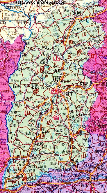
ADMINISTRATIVE DIVISIONS OF XINZHOU CITY AND PREFECTURE:
The Prefecture of Xinzhou counts a total of 14 administrative divisions. The city urban area itself is but a small part identified as the Xinfu District (忻府区). The old and original city center, the Xinfu district lies centrally within the southern tip of the Prefecture in the valley of the Yuxi River. Extending upstream from the ancient city and its city walls lies the new city, identified as Yuanping City (原平市).
Together, the old and the new city form the core of Xinzhou Prefecture, with the 12 remaining counties roughly equally distributed in the east and west around the city.
Dingxiang County (定襄县) and Jingle County (静乐县) are situated nearest the and adjacent the old city. Dingxian County lies immediatly due east of the old city of Xinzhou proper. On the opposite side lies Jingle County. In a similar fashion, the new city is bordered to the east by Wutai County (五台县) in the north, and Dai County (代县) south of Wutai.
The remaining rural 8 Counties of Xinzhou Prefecture are: Fanshi County (繁峙县), Ningwu County (宁武县) - famous for its Ningwu Pass of the Great Walll of China, Shenchi County (神池县), Wuzhai County (五寨县), Kelan County (岢岚县), Hequ County (河曲县), Baode County (保德县) and finally Pianguan County (偏关县) which is centered on the county town of Piangguan and is a famous pass of the inner layer of the Great Wall of China in Shanxi Province and a popular place for along the Wall hiking.
Three Counties lie situated to the east of Xinzhou old and new City. These Dai County, Wutai County and Fanshi County. To the west of the city lie an additional 6 counties, from south to north these are: Kelan County, Wuzhai County and Shenchi County, neighbored by the outermost counties of Baode, Hequ and Pianguan. The latter counties all border on the Yellow River (Huang He) across of which lies the territory of Shaanxi Province.
Find DrBen and ChinaReport on Facebook with the latest from www.drben.net.
In addition to the Xinzhou Airfield, a large airport can be found just south of Xinzhou near the provincial Capital of Taiyuan. A third civilian airport in the region is the new Datong Yungang Airport, at the city of Datong due north of Xinzhou. Both these airfields can be reached easily by train or road from Xinzhou.
China Report - Map of the Great Wall during the Ming Dynasty
Satellite image of China and North-East Asia, with a super-imposed schematic Map of the location and Path of the Great Wall as constructed during the Reign of the Ming Dynasty. Included for reference are City names, geographical features of landscape, Names and locations of Passes on the Great Wall of China.