Ethnic Minorities in Chaoyang & Prefecture
Learn More about the Minorities of the Area !
Chaoyang City & Prefecture Today :
History of Chaoyang :
Coming Soon !!
Chaoyang Climate & Weather :
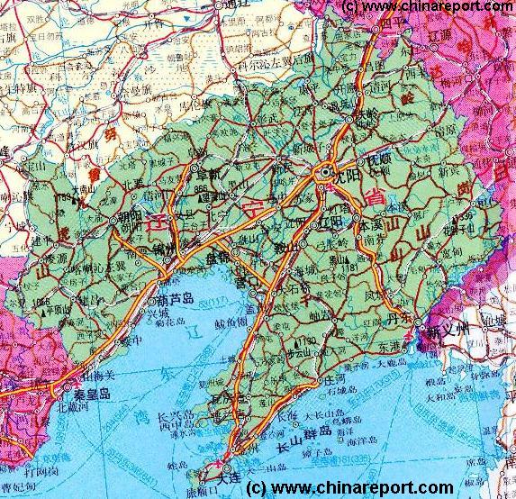
Geographic & Historic Maps on Chaoyang and related Regions of Liaoning Province.
To The China Report Main Menu
This page was last updated on: August 18, 2013
The Chaoyang Report
Introduction to Chaoyang ()
Chaoyang Landmarks & Monuments
Chaoyang & Area Maps
Chaoyang is al City of the North-Eastern Coastal Province of Liaoning, a part of Manchuria. It is one of the largest cities in the region.
Go to www.drben.net webring
All Maps of Chaoyang, Liaoning Province
To Main Menu of All Websites at DrBen.Net
ChinaReport.com at
Please browse around the City of Chaoyang and wider Area using our Geographic & Historic Maps. Find out more about the City and Area through our many Photographic Reports on the main historic landmarks and Monuments and their rich history.
Alphabetically ordered list of Monuments, Landmarks in & around Town
Among the many landmarks of Chaoyang - No information available.
Chaoyang Transport
Main Railroad Station of Chaoyang - Photos and Introduction
Chaoyang has one main railway station and no airport.
No additional information available.
Book Hostels Online Now
Complete Listing of available Hotels in Chaoyang, Liaoning Province, China (PRC).
Chaoyang Basic Knowledge

Location coordinates: ....
Elevation : Not available.
Surface Area (of City Prefecture): 13,000 Sq kilometers.
Population: The Total Population of Chaoyang City and its Prefecture is around - no information available.
Click to go to Full Version Han Dynasty Empire & Connections Map !!
Today's Chaoyang is ...
The Mysteries of the Imperial Palace in History DVD - Buy it Here !
The Great Leap (Forward) - Communism in the Peoples Century Buy the DVD Film !
- Click Here
Map of China during the Rule of the Han Dynasty (206 BC - 221 AD) with the main trading roads of the Empire, the Silk Road and location of Huixian marked.
Huixian + County
life to a natural ...
In history the city or rather town of Chaoyang ...
Find out about Christianity and more facts on the China of Today !
Source Book
"Christianity in China"
( available from our Online Store )
View the Land & Maritime Silk Road (of the Yuan Dynasty Era)
Map Trade Routes in Asia in the 13Th Century.
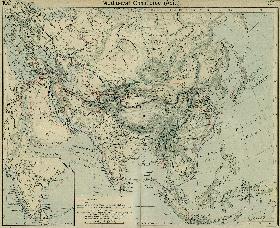
A Schematic Map of the Eurasian Trade Routes existing in the 13Th Century. Clearly marked in Red Accent on the Map are the cities of the network of land-bound trading routes through Central Asia known as the Silk Road (the path of Marco Polo and others).
Click Image to View Book in Online Store !
Source Book
"Liaoning - Home of the Manchus, Cradle of the Qing Empire"
( available from our Online Store )
Liaoning Province
Liaoning Province Home
Shenyang Hotels
Shenyang
Shenyang Home
Shenyang Maps
AsiaReport.com Home
China Offline Sources
China Report Home
China Online Sources
China Online Store
China Maps
China
China Photo Galleries
China Report Club
Anshan
Anshan Home
Benxi
Benxi Home
Liaoning Sources
Liaoning History
Liaoning Maps
Monuments & Sights
Ethnic Minorities
Public Transport
Beining
Shahaisuo
Jianping
Liaoyuan
Sinuiju
Huanren
ChiFeng
Harqin
SuiZhong
Zhangwu
ChangHai
Tiecha Shan - Taoist Holy Mountain (Height ??? Meters)
Benxi Water Cave National Park
HuaBozhi Shan (Height 1336 Meters)
Benxi
Anshan
Dandong
Shenyang
Tiger Mt.
Liaodong Peninsula
Qian Shan Mts.
Dagu Shan (Height --- Meters)
Golden Stone Beach
Wulongbei Hot Springs
Tiger Mountain Great Wall of China - Outer Layer (Ultimate) East Terminus (in China) - Height 1463 Meters
Fenghuan Shan (Height 840 Meters)
Qian Shan (Height 708 Meters)
Dandong National Airport
Great Wall of China - East Terminus (Old Dragon's Head)
Shahaisuo
Xingcheng
Daqing Shan (height 1155 Meters)
Dalian - Zhoushuizi  International Airport
Anshan, Anshan Prefecture
Xiao WuTaiShan (2870 Meters) + Monasteries
Marks location of Monument or Cultural Historic Site
Marks National or International Airport
Beijing "Capital" - International Airport
Beijing City
Marks City, Town or Village
Xiao WuTaiShan (2870 Meters) + Monasteries
Marks Mountain and Height in Meters
Yingkou, Yingkou Prefecture
Yingkou
Jilin
Koreas
Fuxin, Fuxin Prefecture
Great Wall of China -Qinghuangdao
Shenyang, Capital of Shandong Province
Inner Mongolia AR
BaoDe
Qinhuangdao, Qinhuangdao Prefecture, Hebei Province
Hebei
xxx Airport
Shenyang International Airport
Haicheng
Liaoyang
Benxi, Benxi Prefecture
Xianshi
Liaoyuan, Jilin Province
Shuangliao, Jilin Province
Xinmin
Jinzhou, Jinzhou Prefecture
Chaoyang, Chaoyang Prefecture
Qiansuo
Suizhong
Lamadong
Jincheng
Du Shan (height 1677 Meters)
Xiabancheng
Jinxian
Haihe'kou, Jilin Province
Fengcheng
Gaixian
Lushun (Port Arthur)
Zhuanghe'
Kuandian
Kaiyuan
Jianping
Chifeng, Chifeng Prefecture, Inner Mongolia AR
Beining
- Click Map to Enlarge to Full Detail Version -
Yellow Sea
Bohai Sea
Shajianzi
Tschhosan (North Korea)
Sup'ung Lake
Liao He
Liao
  He
Yalu
River
LaoHa He
Nulu'erhu
Mts.
Siping, Jilin Province
Xinkai He
Dalian
Dalian, Dalian Prefecture
Fushun
Fushun, Fushun Prefecture
Jinzhou
Fuxin
Siping
Chaoyang
Jincheng
Dashiqiao (The Three Way Point)
Tieling, Tieling Prefecture
Tieling
Haihe'kou
Tonghua, Jilin Province
Tonghua
Qinguangdao
Zhangwu
Harqin
BeiPao
Beipao
Huanren
Be a 7Search.com Advertiser!
In Chaoyang City Prefecture the main ethnic group are the Han People.
Chaoyang & Area Hotels
Qinhuangdao Airport - Photos and Introduction
In summer visitors to Chaoyang suffer from overwhelming heat and incredible humidity, whereas winters -as elsewhere in the north and east- are generally bone chilling and extremely cold. In winters snow and sleet are common. Daytime sub zero temperatures are standard from December until late februari if not longer.
There is no additional information on the climate in Chaoyang.
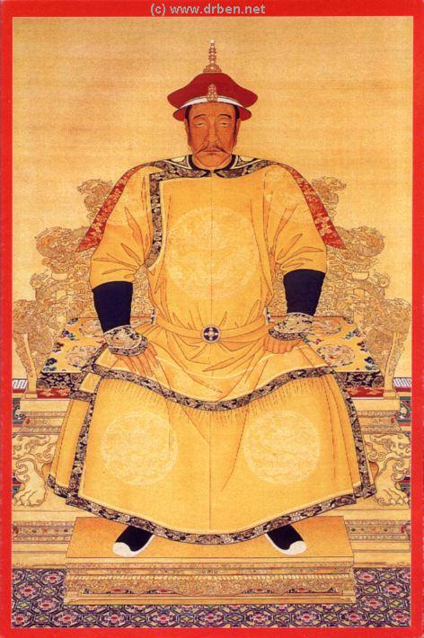
Emperor Tai Zu or Northern Manchukuo Prince Nurhachi
Click to Enlarge - Opens in New Window
The autobiography of Last Emperor Pu Yi, and more available from our Online Store !
Source Book from Emperor to Citizen
( available from our Online Store )
Historic Map - China (Qing) Empire in 1910 AD
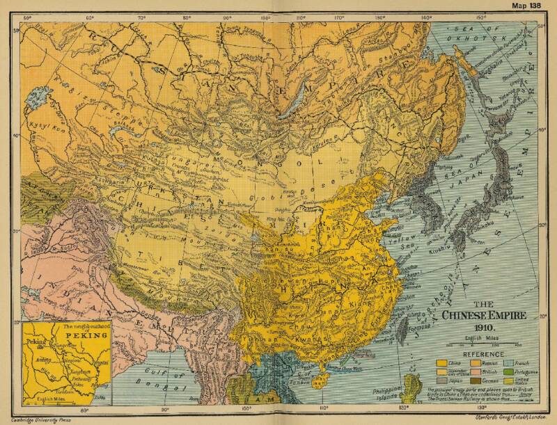
An obviously non-Chinese but western-inspired and made Map of the Ching Dynasty Chinese Empire in the year 1910 AD, a year in which China's sovereignty has been under threat and siege for over 70 years.
In this Map of 1910 AD, made one year before the abdication of Last Ching Emperor Xuan Tong and the final end of China's Feudal History, China is depicted as in it's smallest boundaries and definition. Most notably Manchuria, and Inner Mongolia, both territories nominally under Chinese Control and under Chinese Sovereignty are depicted as separate area's. Manchuria is the ancestral home of the Aisin-Gioro Clan of the Ching Dynasty.
Other interesting features of the Map and geography of the Time : after the Sino-Japanese war of 1899 AD, both Korea and the Island of Formosa (now Taiwan / ROC) have been annexed by the Japanese Empire.
Treaty Ports, around 80 in total dot the Map of China.
Map of China - Ching Dynasty Empire in 1910 AD
Vintage Art posters and prints
Find DrBen and ChinaReport on Facebook with the latest from www.drben.net.
DrBen Nijhoff | Maak je eigen badge
Click DVD Image to View Product in Store !!
Source DVD
"Journey in China - Shenyang"
( available from our Online Store )
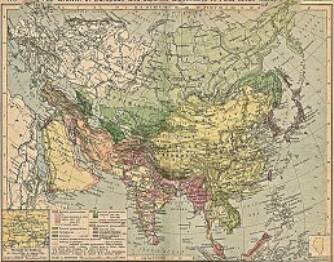
China Report - Colonialism - Growth of Colonies & Japan after 1801 AD
A Map drawing of the Eurasian continent , parts of North-East Africa and the Middle East in the 19Th Century between 1801 AD and 1900 AD. Focal points are the expansion of western colonial posessions of Portugal, Britain and France, as well as Russia moving from West to East. Labeled seperately is the later Rise of the Empire of Japan in the East.
Included in this Map are the main cities across the continent with their brief histories and events during the 19Th Century. Marked in Colors for clarity are the various colonial and imperialist Nations. As relating to China; special attention is payed to so called Treaty Ports. The First Treaty Ports were forced open by Britain in the year 1841 AD, but counted over 80 in total by the end of the 19Th Century. The most important Treaty Ports in China are marked and described with a short history where the map allows.
Map China and Far East Colonies after 1801 AD
Chaoyang
Chaoyang Home
Dandong
Dandong Home
Fushun
Fushun Home
Fuxin
Fuxin
Huludao
Huludao
Jinzhou
Jinzhou
Liaoyang
Liaoyang
Panjin
Panjin
Tieling
Tieling
Yingkou
Yingkou
Dalian
Dalian
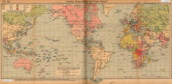
Colonialism - 1912 World Map of Colonial Possessions & Trade Routes.
A Map drawing of the World depicting the Colonial Possessions as they were distributed in 1912 AD. Superimposed and marked in colors are subsequent changes in Influences Spheres, colonies and possessions due to World War I ( 1914 AD - 1918 AD).
Included in this Map are the main cities across the continents with their brief histories and events during the late 19Th Century and early 20Th century, where relevant. Marked in Colors for clarity are the various colonial and imperialist Nations. As relating to China; special attention is payed to so called Treaty Ports. The First Treaty Ports were forced open by Britain in the year 1841 AD, but counted over 80 in total by the end of the 19Th Century.
Click through for Full Version !!
Tweets by @ChinaReportcom1
Follow and Respond to us on Twitter :
Sinuiju, North Pyongang Province,  D.P.R.K. (North Korea).
Dandong, Dandong Prefecture
Changhai (Island)
Huludao
Huludao
Check out MEGA - 100% Secure file-sharing by Kim.com !!
The China Report
The Chaoyang Report is part of the overall website www.ChinaReport.com & www.drben.net
Learn about what is new on this Site from below window.
Hi! from Doc Ben and Proud Staff
Click to Go to Large Scale Map 1A
Chaoyang
Chaoyang, Chaoyang Prefecture
This page was last updated on: August 18, 2013
My Great Web page
Google supported Map of Chaoyang in Chaoyang Prefecture of Liaoning Province (P.R.C.), by AsiaReport.com

AsiaReport.com - Mastermap of Asia (entire). weergeven op een grotere kaart
Lamadong