Geographic & Historic Maps on Shenyang and related Regions of Liaoning Province.
This page was last updated on: August 19, 2013
The Shenyang Report
Introduction to Shenyang (沈阳)
Shenyang Landmarks & Monuments
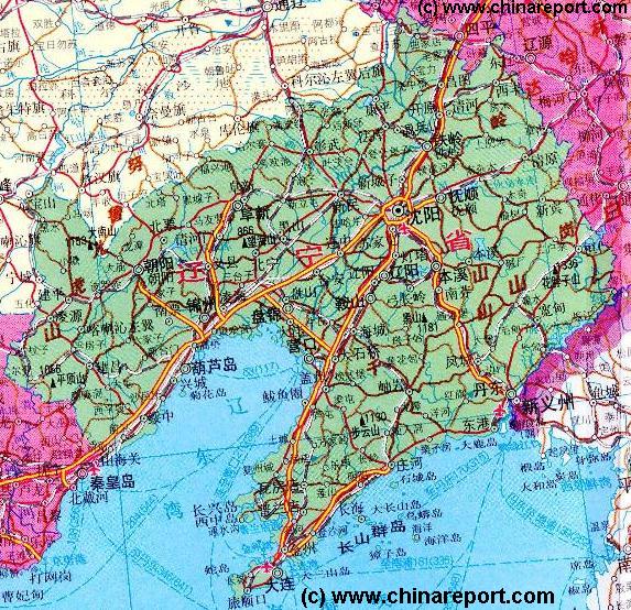
Shenyang & Area Maps
Shenyang (Simplified Chinese: 沈阳 ; Manchu: Mukden) is the Capital City of the North-Eastern Coastal Province of Liaoning, a part of Manchuria. It is one of the largest cities in the region.
ChinaReport.comat
Please browse around the City of Shenyang and wider Area using our Geographic & Historic Maps. Find out more about the City and Area through our many Photographic Reports on the main historic landmarks and Monuments and their rich history.
Among the many landmarks of Shenyang City, the Shenyang Imperial Palace of the Ching Dynasty (1644 AD - 1911 AD) is the biggest tourist attraction closely followed by the renowned Shenyang Horti-Cultural Expo. The Shenyang Imperial Palace, the so-called Zhao Tomb and the Fu Tomb are the three UNESCO confirmed world cultural heritage sites of the City and Prefecture.
The huge Horti-Cultural Exposition is another main Tourist attraction in Town. This large complex showcases a large variety of plant species, examples of world architecture and modern architecture. It regularly hosts associated events such as rallies to promote awareness about the environment and prevent environmental damage. As such the Shenyang Horti-Cultural Expo is one of the two large such showcases within the Nation, the other found in the eternal spring city of Kunming, Capital of Yunnan Province. With a core area of 2.5 square kilometers, the Horti Cultural Park of today is situated at some 17 kilometers from the Suburban Center of Shenyang City. Based upon an existing garden the park was expanded overtime and is now home to one of the largest collections of plant species in China. Apart from the core venue of the Horti-Cultural Expo there are several sub-venues, among which the so called bird island, a newly created habitat of 5.6 square kilometers which is supposedly already home to over 100 species of rare birds, counting well over 10.000 animals. Among all the natural wealth collected at the expo, visitors can enjoy an imposing number of architectural styles among which the traditional ancient Chinese Styles, landmarks from across the world, a Holland Village complete with windmill and lately some stunning high tech modern architecture. Proud additions in this category have been the Rose Park, a 72 meter leaning tower building at an inclination of 76 degrees with adjoining hall with 4168 meters of floor space, a flashy lily shaped watchtower and a huge comprehensive exhibition hall. Area's within the expo zone include Beijing Park, Shenzhen Park and a The Netherlands (Holland) Park.
The Horti Cultural Expo, although always open for visitors, is not a yearly recurring event. Preparations for a major Expo Show take up an average of 20 months. More to come next Expo !
Shenyang Transport
Shenyang has one main railway station and an airport.
Shenyang is the major railroad connections hub in the North-East of China. The six main railway lines in the region, including those leading to the DPRK (North Korea) and the Russian federation meet at the City of Shenyang. Via Shenyang trains connect to Changchun and Harbin.
Shenyang Taoxing Internationaal Airport is the largest airport in the region, connecting with 56 Chinese Domestic destinations as well as Japan, South Korea, the U.S.A. , Australia and Hong Kong.
Shenyang Basic Knowledge
Location coordinates: 41°47′44″ North 123°26′53″ East
Elevation : Not available.
Surface Area (of City Prefecture): 13,000 Sq kilometers.
Population: The Total Population of Shenyang City and its Prefecture is around 7.4 millions souls (7.396000 in 2005 Census) of whom the majority 5+ million reside in the urban areas.
Today's Shenyang is a completely modern City with few historic landmarks to remind of the Past. Not only is it the largest city in North-Eastern China, it is also the main logistic and communications center in that region. In this regard one might say: all roads lead to Shenyang. That is, one has to pass through the city of Shenyang to reach either the Russian Federation or the Democratic Peoples Republic of (North) Korea (DPRK) by train or road. In addition, 6 main railway lines in the north-east meet at Shenyang city.
In addition, Shenyangs Taoxing International Airport is a major air-connection hub in the region, offering flights to 58 Chinese destinations flights to Russia, South Korea, Japan, the United States of America, France, Australia and Hong Kong (S.A.R.).
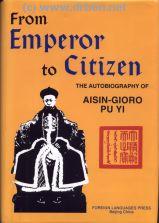
The Main historic attractions are found in the architectural and organizational legacy of the Japanese occupation of the City (1937 AD - 1945 AD) and the even older Imperial palace of the Manchu Qing Dynasty (1644 AD - 1911 AD). Also known as Pu Yi's Palace, referring to the Last Emperors' stint as stooge ruler of the subordinate 'Nation' of Manchukuo, the Palace is a huge estate found in the center of the City.
The Great Leap (Forward) - Communism in the Peoples Century Buy the DVD Film !
- Click Here
Map of China during the Rule of the Han Dynasty (206 BC - 221 AD) with the main trading roads of the Empire, the Silk Road and location of Huixian marked.
No information available.
In history the city or rather town of Shenyang was Mongolian and manchu trading post for most of the Time. During its history the city was also known as Shengjing (盛京) or Fengtianfu (奉天府).
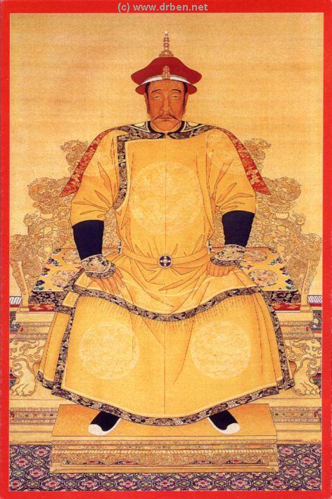
Only in the 17Th Century Shenyang rose to regional importance as the Capital City of the Manchu Kingdom of North-Eastern China established largely by Chief Nuerhachi who became the First King of this rising new Nation.
The Manchu Clan of Aisin-Gioro ruled over the city of Shenyang and large parts of Manchuria and Inner-Mongolia before they finally emerged as the new rulers of China, allowed within the confines of the great wall of China, crushing a peasant rebellion while capturing the City of Beijing in 1644 AD and establishing the Ching Dynasty (1644 AD - 1911 AD).
In the late 19Th Century and the beginning of the 20Th
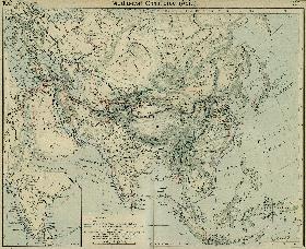
A Schematic Map of the Eurasian Trade Routes existing in the 13Th Century. Clearly marked in Red Accent on the Map are the cities of the network of land-bound trading routes through Central Asia known as the Silk Road (the path of Marco Polo and others).
Traditionally, Shenyang has been known as a major base for heavy industry and manifacturing since the 1930s. As such its products are renowned throughout the Nation. Within North-East China (Manchuria) the City of Shenyang is the main manifacturer and logistics center with trade routes radiating from this important city. Where not so long ago, the State dominated and controlled 99% of all industries, in todays Shenyang the situation has been reversed, with privately owned enterprises making up well over 50% of the cities yearly economic turn-over and available capital.
On top of its national function as a industrial supply base, Shenyang has trade connections with well over a 100 regional cities and serves as a major financial and banking hub for the region and beyond.
As a base city for heavy industry Shenyang used to have a large environmental problem and heavy air pollution. After the year 2000 however, the city has made large investments in order to become one of China's leading green cities. Among things a large tree planting effort was launched turning Shenyang into acity of trees, forests and parks. At present the forested area's within the city have reached over 114 square kilometers. Apart from this the city prefecture has set up no less than 13 natural reserves around the urban city center, taking up some 13% of the city and region. In the last few years, as was done on a National level, pollution controls and environmental laws were strengthened, metal smelteries, paper making industries and other heave water users and polluters have been moved or shut down. A vital improvement necessary for long term public health in the city has been the addition of a comprehensive and fully modern sewage system, finally ensuring the proper treatment of waste waters in the city. Another five sewage treatment facilities were upgraded bringing the percentage of waste waters treated up to 71% in the year 2004. Since water management has reached even higher standards.
Surprising to many first time visitors, Shenyang, apart from its powerful industrial base is also a city with a large agricultural sector. Within the prefecture there are some 720.000 hectares of arible land, resulting in no less than 10 main agricultural trades within the City.
Shenyang's Horti-Cultural Expo, the respresentative business of the Town is co-sponsored by the Chinese Ministry of Commerce, The Ministry of Construction, The China National Tourism Administration, the China Council for the promotion of Foreign Trade and naturally, the China Flower Association. Since the 2006 season various Provincial Agencies have also been involved in its organization.
The Horti-Cultural exposition of Shenyang typically includes over 50 Chinese domestic expositions, representations by well over 20 foreign companies with their own parks. Each edition new landmark buildings are added to the expo terrain.
As the largest city within North-East China Shenyang is home to many Universities and Colleges and research institutes.
Source Book
"Liaoning - Home of the Manchus, Cradle of the Qing Empire"
In Shenyang City Prefecture the main ethnic group are the Han People.
Shenyang & Area Hotels
In summer visitors to Shenyang suffer from overwhelming heat and incredible humidity, whereas winters -as elsewhere in the north and east- are generally bone chilling and extremely cold. In winters snow and sleet are common. Daytime sub zero temperatures are standard from December until late februari if not longer.
There is no additional information on the climate in Shenyang.
Emperor Tai Zu or Northern Manchukuo Prince Nurhachi
century Japan and Russia were struggling for control over these far flung regions attempting to pry them away from the dying Qing Dynasty Empire. In the process Russia gained permission to build railroads across Manchuria, effectively extending their control over Liaoning Province and the City of Shenyang.
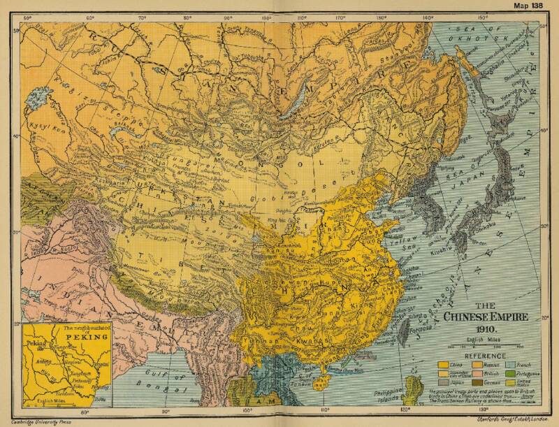
Historic Map - China (Qing) Empire in 1910 AD
An obviously non-Chinese but western-inspired and made Map of the Ching Dynasty Chinese Empire in the year 1910 AD, a year in which China's sovereignty has been under threat and siege for over 70 years.
In this Map of 1910 AD, made one year before the abdication of Last Ching Emperor Xuan Tong and the final end of China's Feudal History, China is depicted as in it's smallest boundaries and definition. Most notably Manchuria, and Inner Mongolia, both territories nominally under Chinese Control and under Chinese Sovereignty are depicted as separate area's. Manchuria is the ancestral home of the Aisin-Gioro Clan of the Ching Dynasty.
Other interesting features of the Map and geography of the Time : after the Sino-Japanese war of 1899 AD, both Korea and the Island of Formosa (now Taiwan / ROC) have been annexed by the Japanese Empire.
Treaty Ports, around 80 in total dot the Map of China.
During the Japanese occupation of Manchuria, officially between 1937 AD - 1945 AD but with a much longer history as a conflict, the city of Shenyang was chosen for a historic reenactment of China's fallen Ching Dynasty, becoming the Capital of the Japanese Puppet State of Manchukuo. The nominal head of the Government of Manchukuo was none other than China's abdicated last Emperor Aisin-Gioro Pu Yi, who during his stint under full Japanese contol resided in the Imperial Palace in the Center of Shenyang. Today it is the most important historic attraction in the city.
China Report - Colonialism - Growth of Colonies & Japan after 1801 AD
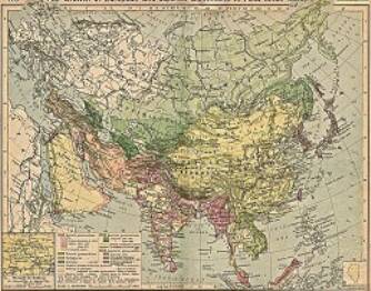
A Map drawing of the Eurasian continent , parts of North-East Africa and the Middle East in the 19Th Century between 1801 AD and 1900 AD. Focal points are the expansion of western colonial posessions of Portugal, Britain and France, as well as Russia moving from West to East. Labeled seperately is the later Rise of the Empire of Japan in the East.
Included in this Map are the main cities across the continent with their brief histories and events during the 19Th Century. Marked in Colors for clarity are the various colonial and imperialist Nations. As relating to China; special attention is payed to so called Treaty Ports. The First Treaty Ports were forced open by Britain in the year 1841 AD, but counted over 80 in total by the end of the 19Th Century. The most important Treaty Ports in China are marked and described with a short history where the map allows.
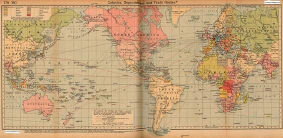
Colonialism - 1912 World Map of Colonial Possessions & Trade Routes.
A Map drawing of the World depicting the Colonial Possessions as they were distributed in 1912 AD. Superimposed and marked in colors are subsequent changes in Influences Spheres, colonies and possessions due to World War I ( 1914 AD - 1918 AD).
Included in this Map are the main cities across the continents with their brief histories and events during the late 19Th Century and early 20Th century, where relevant. Marked in Colors for clarity are the various colonial and imperialist Nations. As relating to China; special attention is payed to so called Treaty Ports. The First Treaty Ports were forced open by Britain in the year 1841 AD, but counted over 80 in total by the end of the 19Th Century.