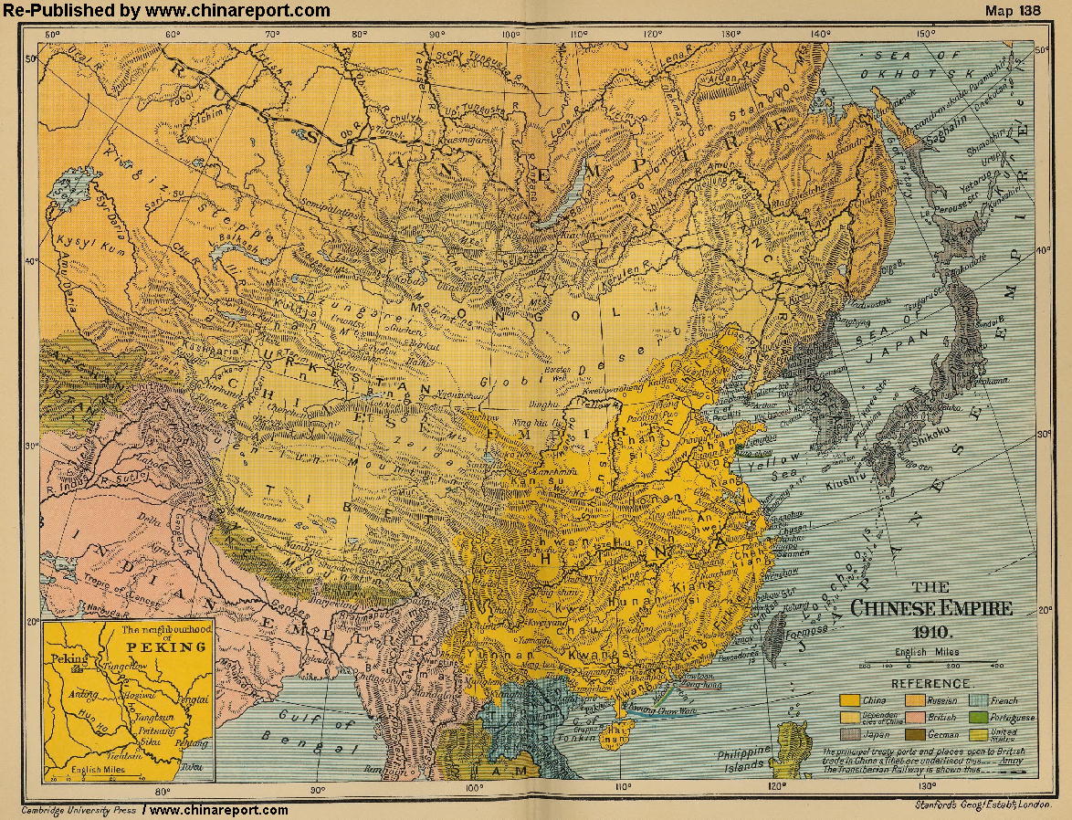
An obviously non-Chinese but western inspired Map of the Qing Dynasty Chinese Empire in the year 1910 AD, a year in which China's sovereignty had been under threat and siege for over 70 years. The Qing Dynasty ended in 1911 AD, when the First Republic of China was established.
In this Map of 1910 AD, made one year before the abdication of Last Qing Emperor Xuan Tung (a.k.a.Aisin-Gioro Pu Yi) and the final end of China's Feudal History, China is depicted as by its smallest boundaries and definition.
Most notably Manchuria (currently Liaoning, Jilin and Heilongjiang Provinces), and Inner Mongolia, both territories nominally under Chinese Control and under Chinese Sovereignty are depicted as separate area's. Last but not least are the Western Territories of China (Chinese Turkestan, Mongolia and Tibet). These large and mineral rich strategic regions were equally under interest of outside Parties Japan and Russia and India-Britain and already under dispute in 1910 AD.
Clearly marked are the so called "Treaty Ports", which were sea and later river harbors that were forcably opened under treaties forced on China after crushing defeats in the "Opium Wars" 1840 AD and 1860 AD.
Other interesting features of the Map and geography of the Time : after the Sino-Japanese war of 1895 AD, both Korea (1910 AD official) and the Island of Formosa (now Taiwan / ROC) have been annexed by the Japanese Empire.
The China Report
Map China - History - Qing Dynasty Chinese Empire in 1910 AD
Designates British Treaty Ports & Territory in Asia
Designates Portugese Territory or Treaty Port
Designates Chinese Controlled Territory or City
Designates French Treaty Port or Territory in Asia
ChinaReport.comat
Treaty Ports :
The first five treaty ports in China were forcably extracted in the 1842 AD Treaty of Nanjing, that
marked the end of the so-called "First Opium War" (1840 AD - 1842 AD). These first Ports were succesively Shanghai, Ningbo, Guangzhou (Canton), Foochow (FuZhou) and Amoy (XiaMen). In 1860 AD more Treaty Ports, and the Beijing Legations, were forced under a new surrender Treaty in the second Opium War (known also as the Arrow War). At this Time the Kowloon + New Territories lease was added to the Hong Kong British Colony.
At First only coastal cities were elected and targeted to become Treaty Ports. Later important Cities on China's major rivers, which were its main interior transport routes, were also forcably opened, with Japanese, American, British, Dutch and other Naval Vessels patroling the Jiangste River as far as Wuhan in Hubei Province and beyond.
Eventually more than 80 treaty ports were established in China. Other Asian Nations such as Japan and Korea and others had similar treaties forced upon their sovereignty.
Territories under Chinese Control :
As mentioned above in the introduction to this Map, the Heartland of Chinese Culture and the Qing Dynasty Empire is depicted seperetaly (in Yellow) from the Regions Nominally under Chinese Contol. From North to South and Clockwise around these are:
Firstly, the vaguely defined Region of "Chinese Turkestan", which in this Map includes current day Xinjiang-Uygur Autonomous Region, the Tarim River Basin (and Taklamakan Desert) and the Region of Gansu Province due West of the Last Fortress on the Ming DynastyGreat Wall of China at JiaYuGuan & Fortress. Turkestan was a collection of Nomadic States during a prolonged period of competition with the Xiong-Nu but was conquered by China as early as 200 BC (Battle of Loulan) and the subsequant Han Dynasty. Mid 18Th Century it once more became part of the Chinese Empire after Campaigns led by Emperor Kang Xi and Grandson Qianlong annihilated rebellious Islamic Tribes. Other parts of the short-lived state became part of the Russian Empire. All are inhabited by the Uighur Tribes since the 8Th Century AD.
During the establishment of the Manchu Ching House as the Manchu Kingdom of the North, the Manchu Clans had subdued and integrated the Mongolian Tribes. After the Manchu's had firmly established their Qing Dynasty Rule over the Chinese Heartlands a strategic plan unfolded. The remaining Mongolian Tribes which had spawned the Mongol Yuan Dynasty recently driven out of (Han) China were finally subdued after a Battle under direct Military leadership of the Great Qing Emperor Kang Xi. Since then Mongolia had been a Tributary State to the Qing Empire. During the 19Th Century, Russian and Japanese interests in these area's set the scene for lasting attempts to prie the Territory away from the Chinese State (after 1910 AD efforts were renewed). In 1936-37 AD Japanese Subversions in Mongolia supporting armed bands were a pre-lude to the Japanese Invasion of China and a crucial point in the Axis-Alliance Strategy to Rule the World by conquering Asia from East and West.
Third is the large Region of Manchuria, birthplace of the Manchurian Qing Dynasty that ruled China from 1644 AD to 1911 AD. Manchuria on this Map includes the Chinese Provinces of Jilin and HeilongJiang, the latter of which was added under Emperor Kangxi by defeating Russians Troops, and had since between under Chinese Control.The Manchurian Territories would later be annexed by Japan, and turned into a Puppet State named Manchukuo, which was nominally headed by Aisin-Gioro Pu Yi, China's Last feudal Emperor.
Forth and Last on this Map is the Himalayan Region of Tibet. Tibet itself was an independent Kingdom under Leadership of the Lama's of the Yellow Hat Sect of Tibetan and Mongolian Lamaist Buddhism. Contacts with the Chinese (Han) State had been established as early as the Han Dynasty (206 BC - 221 AD) and the Silk Road of China and had grown closer eversince. There were many Cultural and Economical Ties. Tibet had been nominally Autonomous but in Tribute to the Chinese Qing Dynasty Empire since the year 1751 AD under the Qianlong Emperor (1735 AD - 1796 AD), Grandson of the Great Kang Xi. The Lama Kings of Tibet only relinquished their Sovreignty to the Qing Throne under Pressure from Russian Troops and Indian Explorers in the South. They chose to allign with the Manchu Qing because of cultural compatibility and the fact that the Qing Dynasty had long since adopted Lamaist Buddhism as the State Religion.
The Qing Rulers would remain ardent and faithful Lamaist Buddhist until the very end of their days. Tibetans were one of the 5 major races included in the Qing Empire. Monuments in Beijing such as the White Dagoba (Bai Ta) at Beihai Park, constructed for the occassion of a Court Visit by the 5Th Dalai Lama, and other Monuments in Beijing and Hebei Province remind of the close ties between China and Tibet.
In 1901 AD, almost immediatly after the subduing of the large scale Yihotuan (Boxer) Uprising in north and north east China, Tibet was likewise invaded by British Colonial Troops arriving from the South and the Indian Colony. Tibet was placed under British Control after which the British (and Later Indians) tried to re-establish an Indian-Tibetan Border further up North.
Tibet however never accepted nor signed any of the supposed Treaties, leaving the disputed area's legally under Tibetan Control.
In 1950/51 AD Tibet was invaded by China and made into the Tibetan Autonomous Region of China. Tibetans today are once more represented by one of the 5 Stars in the Red Flag of China.