Ethnic Minority Groups of Yunnan Province :
This page was last updated on: May 13, 2017
History of Yunnan Province :
A Full Google Earth Supported Map of Yunnan
Introduction to Yunnan (云南) Province of China
Click Map to go to Full Version !!
Lufeng
Fumin
Jiangcheng
Mojiang
Xinping
Shuangbai
Daocheng
Gongxian
Luxian
Nanxi
Mabian
Dinosaur Fossils
Baima (=White Horse) Snowberg
'First Bend o/t Yangtze River'
Longuqing
Tengchong Volcanoes
Cangshan Erhai Scenic Zone
Weiyuanjiang
Mengwoshuangta Temple
Lincang Snowberg (Height 3504 Meters)
Nangunhe
Washan
Nabanhe Scenic Zone
Dingzhen Octagonal Pavilion
Daheishan
Ruins of Yuanmou
Yuanmou
Jiaozishan
Yilihe
Xianren Cave
Jianshui Scenic Zone
Nanxihe
Daweishan
Laojunshan
Laoshan
Babao
Puzhehei
Bailong Cave
Shilin Stone Forest
Kunming International Horti-Culture Exhibition
Huangguoshu Scenic Zone
Longong Scenic Area
Malinghe Gorge
Zhujiangyuan
Huanglianhe
Yanjin
Fuxian Hu
Nanpan
Jiang
Naban
He
Dong
He
Yuan
Jiang
Cheng
Hai
Lancang
River
Lancang
River
Shan
Wu
Weibaoshan
Yangbi
Er
Hai
Meng
Wu
Jianchuan
Weixi
Lanping
Ludian
Tengchong
Lianghe
Dayao
Yao'An
Nanhua
Jinning
Anning
Yimen
Yunlong
Yongping
Weishan
Midu
Xiangyan
Binchuan
Gaoligang (Height 3874 Meters)
Xundian
Wuding
Luquan
Wuding
Maguan
Malipo
Pingbian
Tonghai
Huaning
Shiping
Jianshui
Yuanyang
Shilin
Luxi
Alu Ancient Cave
Kaiyuan
Swallow Cave
Mile
Funing
Guangnan
Yanshan
Yuxianhu
Qiubei
Jingdong
Fengqing
Shidian
Gengma
Shuangjiang
Lancang
Jinping
Eshan
Yuanjiang
Pu'Er
Jinggu
Song
Da
Hong
Ha
Song
Gam
Cao Bang
Ha Giang
Tuyen Quang
Thai Nguyen
Dien Bien Phu
Phong Saly
Chahe
Kunhing
Kengtung
Mong Hkak
Mong Yaw
Mong Yai
Xingren
Qinglong
Anlong
Xilin
Longlin
Yongde
Manfeilong Pagoda
Menglian
Ximeng
Cangyuan
Menghai
Zhenkang
Longchuan
Ruili
Man Wing
Sawan
Suprabum
Yongren
Eryuan
Heqin
Ninglang
Shouguo Temple
Gongshan
Fugong
Nmai
Hka
Mali
Hka
Putao
Xujong
Muchuan
Meigu
Dongchuan
Gulin
Yongshan
Litang
River
Butuo
Yalong
River
Ganluo
Jiulong
Miyi
Qianwei
Jinkouhe
Yuexi
Xide
Xujong
Dechang
Qiaojia
Muli
Yanyuan
Weining
Luzhou
Xichang National Airport
Yibin
Mianning
Huaping
Xichang
Xiangcheng
Deqen
Derong
Xuanwei
Anshun
Zhenxiong
Luxi International Airport
Simao National Airport
Napo
Luoping
Liupanshui
Wenshan
Lao Cai
Kunming
Lincang
Simao
Jinghong
Luxi
Liuku
Baoshan
Dali
Lugu Hu
Shangri-La
Gejiu
Yuxi
Weixin
Fuyuan
Suijiang
Yibin National Airport
Zhaotong
Lijiang
Panzhihua
Huidong
Weixin
Shan
Moirigkawagarao (Height 6740 Meters)
Xingyi
To Main Menu of All Websites at DrBen.Net
ChinaReport.com at
Go to www.drben.net webring
Yunnan Province of China
Yunnan Province
Yunnan Prov. Home
- Click Map to Enlarge to Full Detail Version -
Highlights, Monuments and Scenic sites of Yunnan Province
Vietnam
Tibet AR
Capital of Yunnan Province - Kunming
Surface Area / Size - Area: over 394,000 Sq. Km (152,000 Sq. Miles).
Population - 44 Million 830.000
Major Cities :
Kunming, Baoshan, Chuxiuong, Dali (Bai), Dehong, Diqing, Honghe, Lijiang, Lincang, Nujiang, Pu'Er, Qujing, Simao, Wenshan, Xishuangbanna, Yuxi, Zhaotong.
Airports
Kunming - Wujiaba International Airport
Baoshan - National Airport
Dali - National Airport
Diqing - Xianggelila Airfield
Jinghong
Lijiang
Lincang
Luxi - Mangshi Airport
Simao (District of Pu'Er)
Wenshan
Xishuangbanna - Gasa Airfield
Zaotong
Full Introduction to Yunnan Province-Soon !!
Map China and Expanding British Empire in 1860 AD
Yunnan Sources
Yunnan Maps
Kunming History
Kunming
Kunming Home
Kunming Maps
AsiaReport.com Home
China Offline Sources
China Report Home
China Online Sources
China Online Store
China Maps
China
China Photo Galleries
China Report Club
Kunming National Airport
Derong (Sichuan Province)
Sichuan
Everything about the Imperial Palace & the Last Two Dynasties !

View AsiaReport.com - Mastermap of Asia (entire). in a larger map
Map of Languages & Distirbution in China !
A Full and complete Map of China (PRC) identifying all Language Areas big and small in all Provinces and Autonomous Regions of China.
Map includes Turkic Languages (Uygur, Kazakh, Kirghiz, Salar & Uzbek), Mongolian Language and Sub-Divisions (Mongol, Tu, Daur and Dongxian), Tungusic Peoples (Oroqen, Evenki and Xibe) and Languages, Korean, Tajik (Tadzhik), Mon-Khmer (Kawa + Puman (or Pulang)), Hui, Uygur (Uighur), Tibeto-Bhurman Languages, Tai and Miao, Yao and She' Language Area's and Borders. Main Area's and sub-divisions of Han Languages (Northern Mandarin, Eastern Mandarin, South-Western Mandarin and Cantonese) further included. This color-coded ethno-linguistic Map (of 1967 AD) identifies at a glance most ethnic minority regions in China
Map China Ethno-Linguistic / Language Distribution China
To China Report - Index/Main Menu


CD Universe - Buy Video Games for Nintendo Wii, PlayStation 3, XBox 360, PlayStation 2, XBox, Sony PSP, GameCube, PC Games at Every Day Low Prices
Help tell the Story of Yunnan Province of China, shop for Music Online !
Panzhihua
Qujing
Zhenyuan
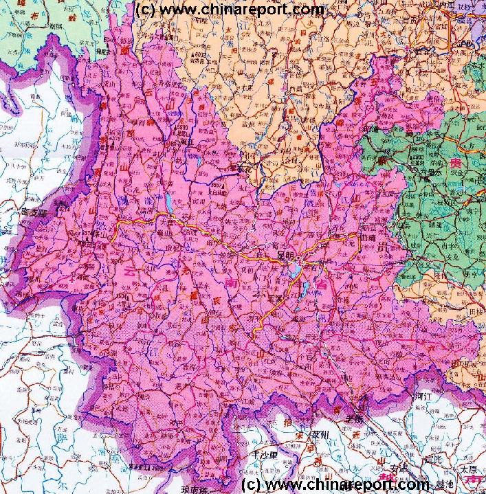
Yunnan Province is located in the extreme south-western corner of the Peoples Republic of China and comprises the southwestern part of the Yunnan-Guizhou Plateau.
Yunnan Province is a border Province. It is neighbored in the South by Vietnam, Laos and in The South and West by Myanmar.
Bordering Provinces and Regions of China are clock-wise around Tibet Autonomous Region, Sichuan Province, Guizhou Province and Guangxi Zhuang Autonomous Region.

With a surface area of well over 380000 km2 Yunnan is among the largest Provinces of the Nation.
Topographically Yunnan is a
Main Rivers and Waterways of Yunnan Province :
Main Cities & Population Centres of Yunnan Province :
Main Railways and Highways in Yunnan Province :
Economy of Yunnan Province :
Climate in Yunnan Province :
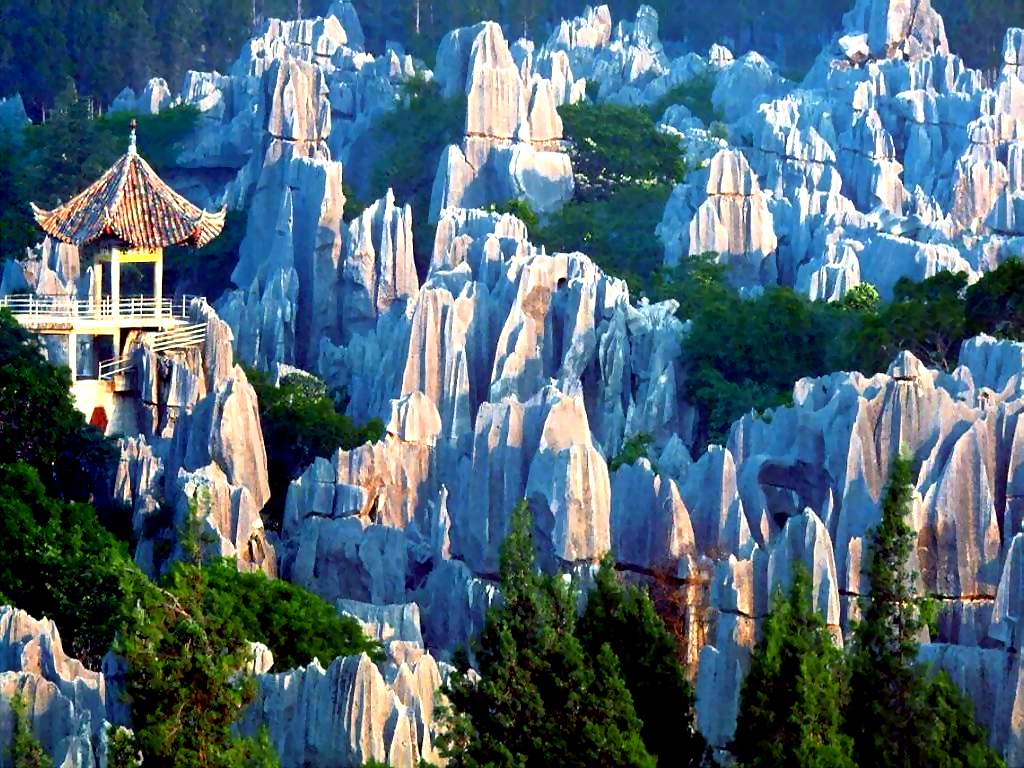
The major famous scenic areas of Yunnan Province include Dianchi Lake in Kunming - the Capital City,  the Liman Stone forest landscapes, the City of Dali, the Xishuangbanna Yulong Snowberg near Lijiang, the Tengchong Volcanoes, Jiuxiang, Jianshui, the Lijiang River and the Daying River, and the scenic area of the Three Rivers Running Side by Side.

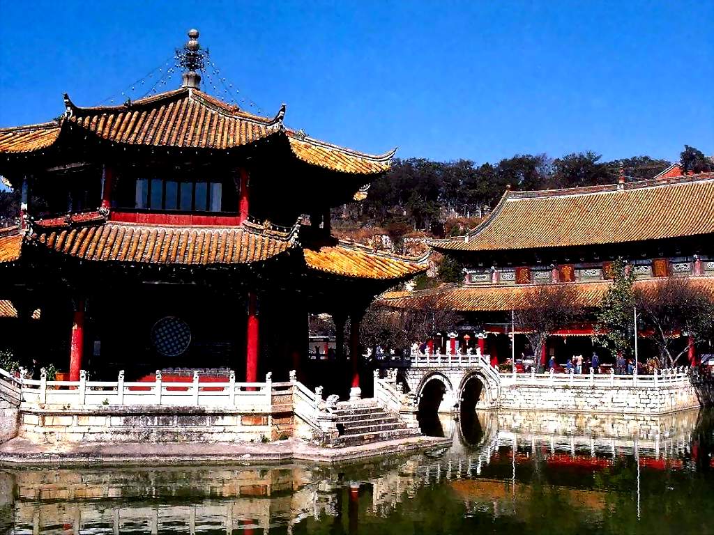
The ancient City of Lijiang has been listed by Unesco as a World Cultural Heritage Site and draws visitors from the World over.
Besides, the tourist activities with distinctive ethnic features attract all the tourists both from home and abroad.
Putao (Myanmar)
Yunnan enjoys a tropic highland humid monsoon climate, characterized by cool summer and warm winter. It is like spring all the year round. The annual average temperature is 13-20°C and the annual rainfall is 1100 mm.
Chongqing
The Fascinating Yangtze River - a New Chapter !!
DVD Documentary on China's Yangtze River - and all of the life that surrounds it undergoing an astonishing transformation wrought by the largest hydroelectric project in history, the Three Gorges Dam. - Click Here
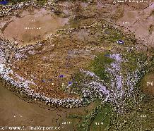
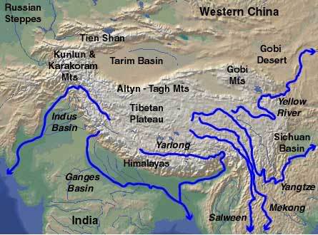
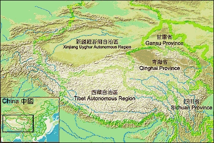
Laos
Myanmar
Xingyi (Guizhou Province)
Qujing
Shangri-La (also Deqen), Diqing Tibetan Autonomous Prefecture, Yunnan Province, China (P.R.C.).
Kunming, Capital of Yunnan Province, China (P.R.C.).
Zhaotong
Weixin
Chuxiong
Chuxiong
Dali, Dali Bai Autonomous Prefecture, Yunnan Province, China (P.R.C.).
Jinghong
Liuku or Lushui
Gejiu
Lao Cai (Vietnam)
Wenshan
Luxi
Lincang
Tibet - Tibetan Plateaux - Satellite Image Overview Map 1A
A Satellite Image overview Map of the entire Tibetan Plateaux including parts of bordering regions of Xinjiang-Uyghur AR, Gansu Province, Ningxia Hui AR, Inner-Mongolia AR, Sichuan Province, and Yunnan Province. Surrounding nations and Territories are: Myanmar (Burma), Bhutan, Sikkim, Nepal, Bangladesh, India, Kashmir and Pakistan.
This Map clearly defines Provinces and Regions, main mountain ranges, main rivers & lakes of the region, Plus locations of main cities and landmarks.
Tibetan Plateaux Satellite Overview
Satellite Image Overview of the Tibetan Plateaux !!
Baoshan
Luoping
Guizhou
Qinglong (Guangxi Zhuang AR)
Simao
Yuxi
Liupanshui (Guizhou Province)
Suijiang
Fuyuan
Napo (Guangxi Zhuang AR)
Guangxi
Zhuang
AR
Zhenxiong
Anshun (Guizhou Province)
Xuanwei
Jinping
Xuanwei
Zayu (Tibet AR)
Zayu
Deqen
Jinsha
River
Lancang
River
Jinsha
River
Nu
River
Xiangcheng (Sichuan Province)
Xichang (Sichuan Province)
Huaping
Mianning (Sichuan Province)
Yibin (Sichuan Province)
Luzhou (Sichuan Province)
Bijie (Guizhou Province)
Bijie
Weining (Guizhou Province)
Yanyuan (Sichuan Province)
Muli (Sichuan Province)
Qiaojia
Dechang (Sichuan Province)
Xuyong (Sichuan Province)
Qianwei (Sichuan Province)
Jinkouhe (Sichuan Province)
Xide (Sichuan Province)
Yuexi (Sichuan Province)
Miyi (Sichuan Province)
Jiulong (Sichuan Province)
Ganluo (Sichuan Province)
Butuo (Sichuan Province)
Jinsha
River
Yongshan
Gulin (Sichuan Province)
Dongchuan
Meigu (Sichuan Province)
Muchuan (Sichuan Province)
Hezhang (Guizhou Province)
Walung
Walung (Tibet AR)
Fugong
Gongshan (Myanmar)
Ninglang
Heqin
Eryuan
Yongren
Heng
Duan
Sawan (Myanmar)
Suprabum (Myanmar)
Myitkyina (Myanmar)
Myitkyina
Ruili
Longchuan
Zhenkang
Cangyuan
Menglian
Ximeng
Menghai
Xilin (Guangxi Zhuang AR)
Longlin (Guangxi Zhuang AR)
Anlong (Guizhou Province)
Ceheng (Guizhou Province)
Wangmou (Guizhou Province)
Wangmou
Xingren (Guangxi Zhuang AR)
Man Wing (Myanmar)
Mong Yaw (Myanmar)
Thanlwin
Hka
Mong Yai (Myanmar)
XXX (Height 2325 Meters)
Mong Hkak (Myanmar)
Kunhing (Myanmar)
Kengtung (Myanmar)
Mekong
River
Chahe (Yunnan Province)
Thanlwin
Hka
Phong Saly (Myanmar)
Dien Bien Phu (Vietnam)
Ha Giang (Vietnam)
Cao Bang (Vietnam)
An Bai (Vietnam)
Tuyen Quang (Vietnam)
Thai Nguyen (Vietnam)
An Bai
Jiangcheng
Mojiang
Eshan
Xinpning
Jinggu
Yuanjiang
Pu'Er
Zhenyuan
Lancang
Shuangjiang
Gengma
Yunxian
Fengqing
Shidian
Yunxian
Yanshan
Qiubei
Guangnan
Funing
Kaiyuan
Mile
Luxi
Shilin
Jiliang
Mengzi
Mengzi
Yuanyang
Jianshui
Shiping
Huaning
Tonghai
Malipo
Maguan
Pingbian
Songming
Songming
Luquan
Xundian
Yongde Snowberg (Height 3504 Meters)
Yongde
Jiangao Shan (Height 3214 Meters)
Midu
Weishan
Xiangyun
Binchuan
Yongping
Yunlang
Yulong Snowboard (Height 5596 Meters)
Lijiang, Lijiang City Prefecture, Yunnan Province, China (P.R.C.).
Jinning
Anning
Yimen
Shuangbai
Dayao
Yao'An
Nanhua
Yuanmou
Longling
Lianghe
Tengchong
Longling
Ludian
Jianchuan
Lanping
Weixi
Shan
Yangbi
Liang
Yangtze
River
Weixin
Xuyong (Sichuan Province)
Yanjin
Changhaizi Black-Neck Crane National Reserve
Guanyinshan
Huizi
Huizi
Manjinglan Village
Wuliangshan Scenic Zone
Jingdong
Ruilijiang-Dayingjiang
Hutiao Gorge
Lufeng
Huidong (Sichuan Province)
Mabian (Sichuan Province)
Nanxi (Sichuan Province)
Luxian (Sichuan Province)
Naxi (Sichuan Province)
Naxi
Gaoxian (Sichuan Province)
Gongxian (Sichuan Province)
Daocheng (Sichuan Province)
Fumin
Luliang
Luliang
Yunnan is a mountain and high-plateaux region, and mountainous areas and plateaux make up 94% of its total area.

Yunnan possesses lofty mountains , deep valleys and torrential rivers , and is inhabited by more than 20 nationalities with different customs. The enormous diversity of the Province, both in cultures and sceneries, forms the basis and tourist industry.
The province boasts abundant famous local product.Yunnan cigarette,Yunnan medicine, and Yunnan tea such as Dianlu, Puler, Dianhong, and Yunnan Ham, etc, are all famous specialities.
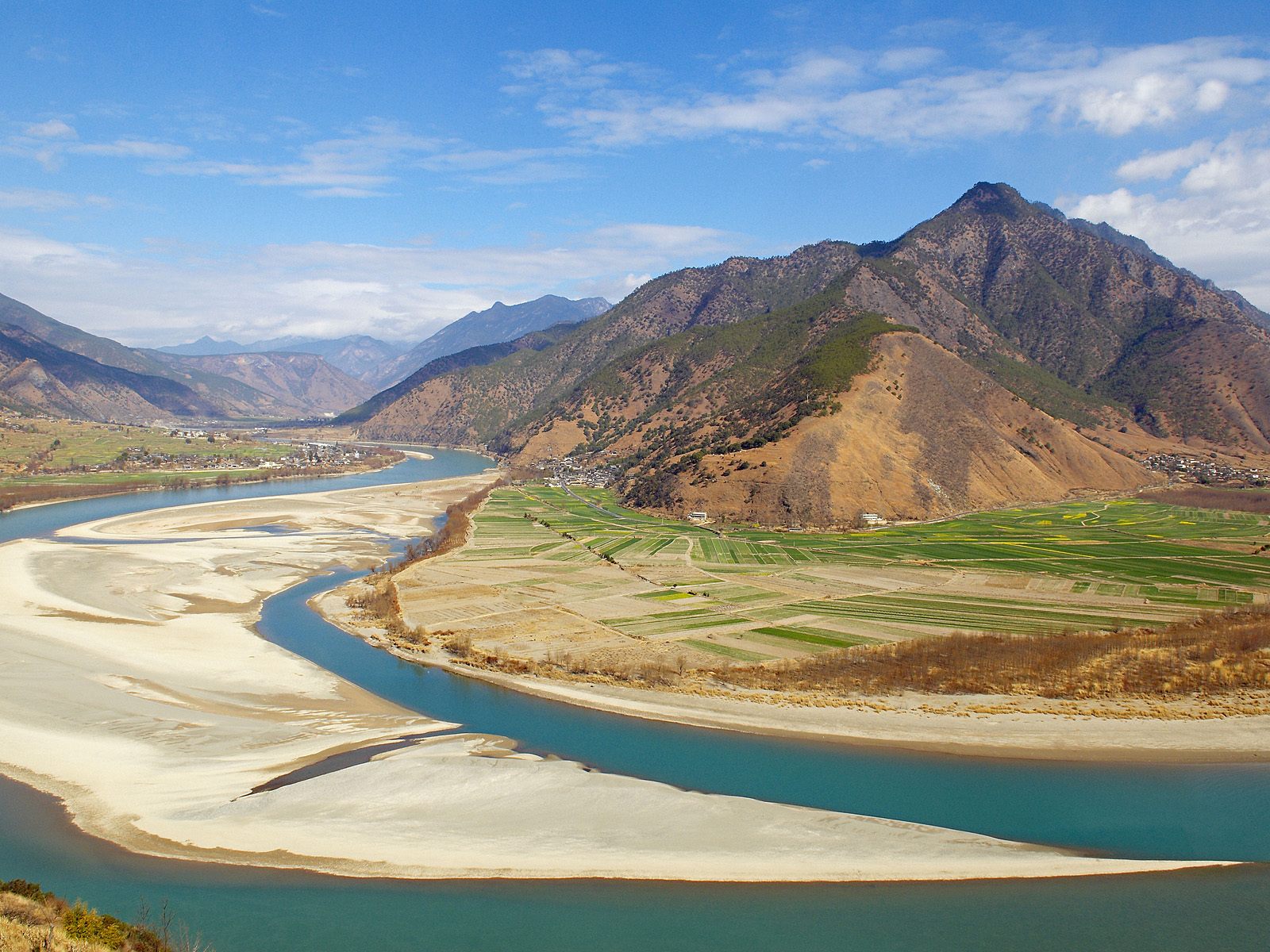
There are many smaller and larger rivers in Yunnan. The Main Rivers in Yunnan Province are the Lancang River, the Jinsha River and the Nu River.
Minor rivers are the Naban He, the Dong He and Nanpan Jiang.
Lakes are Fuxian Hu, Cheng Hai, Er Hai, and xxx in Kunming.
The main cities in Yunnan Province are Kunming (昆明市), Baoshan (保山市), Chuxiuong (楚雄彝族自治州), Dali (大理)(Bai), Dehong (德宏傣族景颇族自治州), Diqing (迪庆藏族自治州), Honghe (红河哈尼族彝族自治州), Lijiang (丽江市), Lincang (临沧市), Nujiang (怒江傈僳族自治州), Pu'Er (普洱市), Qujing (曲靖市), Simao, Wenshan (文山), Xishuangbanna (西双版纳傣族自治州), Yuxi(玉溪市), and finally Zhaotong(昭通市).
Portrait of a Miao Girl with Baby Carrier, Qiubei, Yunnan, China
Portrait of a Miao Girl with Baby Carrier, Qiubei, Yunnan, China Photographic Print
Occidor Ltd
Opening of China National Costume Exhibition, Kunming, Yunnan, China
Opening of China National Costume Exhibition, Kunming, Yunnan, China Photographic Print
Occidor Ltd
Portrait of Woman from the Naxi Minority at Market, Lijiang, China
Portrait of Woman from the Naxi Minority at Market, Lijiang, China Photographic Print
I'Anson, Richard
The flow of the Jinsha (Yangtze) River along the border of Sichuan and Yunnan Provinces..
Eroded karst landscapes of the Stone Forest, a natural labyrinth near Lunan in Yunnan Province.
Click Image to View Book in Online Store !
Source Book
"Yunnan - 'Shangri-La' over the Horizon"
( available from our Online Store )
The
Three Pagodas of Dali at Foot of the Cangshan Mountains, Dali, Yunnan, China
The Three Pagodas of Dali at Foot of the Cangshan Mountains, Dali, Yunnan, China Photographic Print
Mayfield, Diana
The ethnic minorities of Yunnan are the Miao, the Dai, the Dong, the Hani, the Gelao , the Naxi, the Yi and the Tujia People.
Soundbonus - Traditional Chinese Pipa - "Romance of the Red River Valley'. By Liu Fang.
In August 2009, more than 30,000 Kokang refugees fled from Burma into the Chinese border town of Nansan in Yunnan Province due to Burmese army attacks against the Kokang cease-fire rebels, the Myanmar National Democratic Alliance Army (MNDAA).
Find DrBen and ChinaReport on Facebook with the latest from www.drben.net.
DrBen Nijhoff | Maak je eigen badge
Lijiang
Lijiang Home
Pu'er
Pu'er Home
Dali (Bai)
Dali (Bai) Home
Diqing (Tibetan)
Diqing (Tibetan) Home
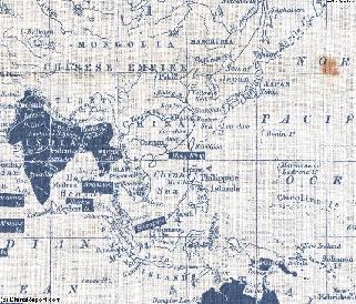
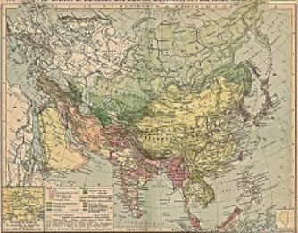
China Report - Colonialism - Growth of Colonies & Japan after 1801 AD
A Map drawing of the Eurasian continent , parts of North-East Africa and the Middle East in the 19Th Century between 1801 AD and 1900 AD. Focal points are the expansion of western colonial posessions of Portugal, Britain and France, as well as  Russia moving from West to East. Labeled seperately is the later Rise of the Empire of Japan in the East.
Included in this Map are the main cities across the continent with their brief histories and events during the 19Th Century. Marked in Colors for clarity are the various colonial and imperialist Nations. As relating to China; special attention is payed to so called Treaty Ports. The First Treaty Ports were forced open by Britain in the year 1841 AD, but counted over 80 in total by the end of the 19Th Century. The most important Treaty Ports in China are marked and described with a short history where the map allows.
Map China and Far East Colonies after 1801 AD