Elevation : -154 Meters ; 154 Meters below Sea Level making it the 2nd lowest point in the world after the Dead Sea (Isreal) and the lowest town or city in the Peoples Republic of China.
Surface Area of the City Prefecture of Turpan: ---- km2 (--- square miles)
Urban Area of Turpan - ---- km2 (----- sq miles)
Population of Turpan Prefecture: 254.900 as counted at the end of the year 2003. Population of Town: 57 thousand 100 in 2007.
Turpan City is the administrative center of Turpan City and the Turpan City Prefecture of West China's Xinjiang-Uygur Autonomous Region. It is situated about 94 miles due south east of the regional Capital of Urumqi. The town of Turpan itself sits inside a low lying region identified as the Turpan Depression which is situated underneath the southern foothills of the Bogda Shan (Bogda mountain range) which extend eastward from the Capital as a snow-topped and high peaked wall.
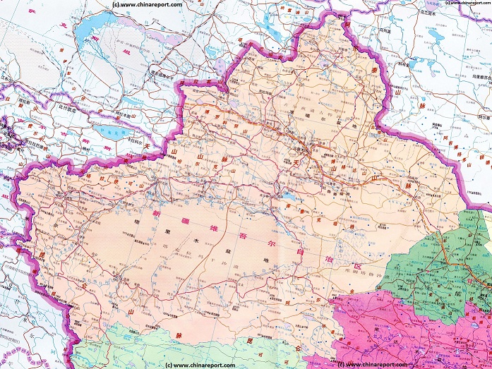
Turpan Prefecture is bordered to the north west by Urumqi Prefecture and by Changji Hui Autonomous Prefecture. To the east of Turpan Prefecture lies the Hami (Kumul) Prefecture, and to the south by the large and mostly empty Bayin-Gholin Mongol Autonomous Prefecture which holds the legendary wandering lake of Lop Nor, China′s (Malin) nuclear testing facilities and a lot of sand of the Taklamakan Desert.
Turpan (Turfan or historically also Tulufan) is a remote yet legendary silk road town, Kingdom and Oasis stop-over along one of the main routes of the Silk Road in what has been known since the Han Dynasty (206 BC - 221 AD) as the western regions. Ever since its first contact with (Han) Chinese civilization, now well over 2000 years ago, the modestly size has made a huge imprint on Chinese history.
Turpan Climate & Weather :
Turpan is noted as both the lowest place within all of the Peoples Republic of China residing at 145 meters below Sea Level, and as the hottest location. Accordingly, even within Xinjiang Uyghur Autonomous Region it has its own specific micro-climate area.
Altogether, Turpan is windless, dry and hot in the summer months, which makes this time of year seemingly the least attractive time to pay a visit. With temperatures reaching up to nearly 50 Degrees Celcius (China′s National Record !) daytime hours are usually sweltering hot with blistering sunshine. Hence, sun glasses (shades), sun block cream, a hat and enough drinking water to last for hours are the minimum package travelers should bring along. As the Turpan County and Prefecture are also desertlike, arid and dusty, a pair of good hiking shoes or even boots may also serve one well. Make sure your footwear is adapted to the circumstances !
Turpan Today :
Ethnic Minorities in Turpan & Prefecture
Due to its longstanding history as a multi-cultural and ethnic corossroads, Turpan is a very ethnically diverse city and Prefecture. Among the current day Ethnic Minorities of Turpan City and Prefecture at this time with a 70% representation the Uyghur form the majority at this time, closely followed by the ever further encroaching Han who already make up some 22% of the population.
The other ethnic groups are far smaller in number. These are mostly Hui (around 7%), while the others are Tujia, Manchu(-Tungusic Peoples, Tu, Mongolian, Tibetan, Kazakh, Miao, Russian (Eluosi), Zhuang and Dongxiang in origin. At least, that is according to official numbers provided by the Provincial and National Governments. The latest census even allows for Persians (i.e. Iranians) to live in Turfan.
History of Turpan :
This page was last updated on: May 28, 2017
The Turpan Report
Introduction to Turpan ( ; )
Turpan Landmarks & Monuments
The beautiful Photo-Journey of Wang Miao and Shi Baoxiu, all the way from the Pamir Highlands in Central Asia, through North China to Beijing along the Silk Northern Route. A jewel of a Book !!
ChinaReport.comat
Various travel guides and tour operators quite different Landmarks of Turpan and the surrounding Prefecture. However, certainly everyone will list the same few monuments and wortwhile places to visit within the old town of Turfan itself. These are the renowned and often depicted Emin Minaret, the xxx and the Turpan City Museum.
The other Monuments of Turpan are all found within the surrounding countryside and low altitutude desert. These are first and fore-most the Bezeklik Thousand Buddha Caves followed by the ruins of Gaochang the ancient Capital of the Uyghur Nation.
Other sites of interest found in the prefecture are the various excavation sites of Tarim mummies
, the Jiaohe Ruins
And further the Flaming Mountains, a location known as Dingling, the Ayding Lake, a place known as Chunche, and last but not least the Turpan Grape Valley which has been turned into one of the most popular tourist attractions of the prefecture together with its underground network of water channels, the so called(Turpan) Karez. Apart from the Minaret in town the grapes and the Kharez are regarded as the must see sights of Turpan, all other things seem secondary.
A Full listing of Turpan City Landmarks, Monuments, Hotspots and other sites of importance in alphabetical order. Search through the list to find your Full Report and Photo-Virtual Tour of each monument or landmark within the City, or Region of Turpan in Xinjiang-Uygur AR of China (PRC).
Turpan Railway Station
Turpan does not have an airport at this time.
The Main and only Railway Station of Turpan City, located due East of the City Center of Urumqi and some distance away along the highway to the East. As the arrival point for many, the Main Station is home to a number of essential Services.
Turpan lies along China National Highway No. G312. The town is also the junction point of the Lanzhou to Urumqi (in Xinjiang) Railroad and southern Xinjiang railroads.
Turpan - Turpan in Xinjiang-Uygur was under Chinese Control by 90 AD, at the very latest. Although incursions by vengeful Nomadic Tribes would threaten and conquer Kashgar and Turpan several Times, Turpan would return to Chinese Rule or Dominance. Today Turpan lies in Xinjiang Autonomous Region of China, due South-East of Urumqi.
The world’s oldest stash of marijuana known to date was found in a tomb in near Turpan. According an article in the Journal of Experimental Botany, the cannabis is about 2,700 years old.
Researchers found all 789 grams of dried cannabis buried beside, what they believe, to be a shaman of the Gushi culture. Dry conditions and the alkaline soil preserved the stash, which enabled scientists to study it.
A (dated) Goegraphic Map of Xinjiang-Uyghur Autonomous Region with its main population centers, roads and railroad, connections, airports, and main geographical features.
In the earliest years of its contacts with Chinese Civilization, it was the center of an independent Buddhist Kingdom of considereable influence in the regions. Later, after having outsmarted the Xiong Nu Tribes in competition, the Han Chinese were able to turn Turpan into an allied Nation and a base for further explorations along the Silk Road. As this allowed the first opening of what was later to become known as the great Silk Road (out of China), Turpan became a window on the outside world for the Chinese, and its culture, including Buddhism was passed on and spread in the wider regions and along the roads towards the Chinese Capital of Chang′An (Xi′An). Eventually this allowed for Buddhism to spread
into China where, over many centuries, it became one of the three accepted religions of the Chinese Realm.
Although, judging from the contents of history books and travel guides alike the last half millenium has seemingly been far less exciting or at least historically noteworthy for the world, there is plenty more to tell about the history of Turpan. Among things, as can be seen today, the town once more reverted back to Islam and stayed that way while remaining a bullwark of Uyghur Culture right up to and somewhat beyond the advent of the Peoples Republic of China.
In the late 19th and in the 20th century Turpan was much visited by western explorers among whom famous names such as Sven Hedin, Sir Marcus Aurel Stein and various less renowned travelers and adventurours while the regions were traversed by Russian geographic missions, Cossack armies and Russian stragglers and refugees.
The Chinese Armies had returned to the west as early as 1946 AD, among things fighting aborder war with Mongolian armed forces someways due north of
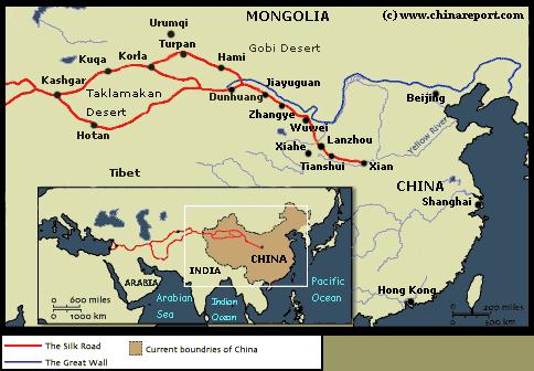
Schematic depiction of the main route of the Silk Road between Central Asia on the left and China on the right. As can be seen, the Turpan Oasis lay along the so called northern branch of the Silk Road.
ash clouds blackened out the sunlight and rained ash and radio active dust from the skies for days. As an illustration, On November 17 in the year 1976, China tested an atomic bomb by dropping it from an aircraft. It was reportedly 320 times more powerful than the bomb that was dropped in Hiroshima. Nightmarish tales exists about the nuclear waste, the fall out, the cleaning methods used and the dead, dying and misformed, all locals and military personal who were there to witness the blasts and live the aftermath. However, as details of the entire nuclear program and especially the ill effects on public health are still considered crucial National Military secrets, one will not find these subjects discussed locally and especially not related to Foreigners or outsiders.
Although the actual Malan Nuclear testing Facility (there are more bases than this officially recognized base!) lies some 165 miles due south of Turpan in the Baiyin-Gholin Mongol Autonomous Prefecture, Turpan is close enough to have felt the full brunt of the testing and many of the victims of this silent disaster can be found living (hidden away) in town and the surrounding countryside.
Whether or not the nuclear explosions and resulting myseries are mentioned, Chinese and International Travel agencies clear consider that in any case, with so many historical persons passing through it and so many historic events occurring there the name of the Turpan Oasis is forever enshrined as among the great mystical places found along the pathways of the ancient Silk Road. Within China its name has been commonplace among
YouTube Video: 6Th Chinese Nuclear Test (CHIC-6) - Atmospheric Blast of a Hydrogen Bomb yield 3300 Kilotons of TNT (vs 16 Kilotons at Hiroshima).
the educated for centuries and among international travelers, explorers, historians and archeologists the mentioning of Turfan ellicits numerous romantic idea′s, memories and thoughts.
READ MORE HISTORIC TALES AND FACTS ABOUT TURPAN IN:
Today the city of Turpan, not withstanding it being the hottest place in China, is a well visited tourist destination and a layed back, yet thriving provincial city in the north of the Tarim River Basin.
Throughout history theTurpan Oasis occupied a crucial strategic location and was literally at a crossroads of Civilizations and cultures. Among things, in the 7Th and 8Th Century, Sogdians and Turks from Central Asia met the Han Chinese but also Tibetans and Mongolians in the town and regions, all vying for economic influence and often ultimate political and military control.
During their early rise the Tang Dynasty (618 AD - 907 AD), the Chinese were again able to dominate the town and affairs along the Silk Road in the regions among things, allowing the Chinese to ply their lucrative trades with the Sogdians and Turks from Central Asia and serving as a bae for military campaigns reaching far beyond into Central Asia. It was in this period that the now famous Buddhist Monk Xuanzang (Life:602 AD - 664 AD) was able to slip out of China (629 AD), on his further journey passing through Turpan where he met the Buddhist King and famously encountered several obstacles on his journey to India. That the Monk later became the court expert on Buddhism in the Chinese Imperial Capital and would be recognized as a founding father of this faith within the Chinese Nation ensured that the name of the town of Turpan would be passed along with his powerful legend.
Map of the Han Dynasty Empire at an early Stage in the 2nd Century BC. Clearly the Chinese have taken control of the Hexi Corridor, the neck of China today a part of Gansu Province. Beyond the Han Dynasty Great Wall of China near Dunhuang (Gansu) in the West, two routes lead into Central Asia. Turpan is found along the northern route and is already marked on the Chinese Maps.
Later, during a period of decline of its Central Powers at the end of the 8th Century the outlying territories of the Empire again fell prey to the longstanding competitions between the rivaling powers in the regions. In the year 792 AD, the Tibetan Empire established under King Songtsan Gampo (Life: Est. 617 - 649 AD) swept northward into the Taklamakan Desert and Tarim River Basin taking the town of Turfan and so taking control of the Silk Road trading routes in that area.
Only a decade later the town changed hands again and became an important city under a Uyghur Moslim Rule known as the Uyghur Khanate. It was at this time that the Buddhist Religion in the Town was exchanged for the Islamic Religion that still holds sway there today. Although this Uyghur Khanate was immediatly assualted by the neighboring Kyrgyz Tribes, the Uyghurs did established a Kingdom in the Turpan region which has its capital in Gaochang or Kara-Khoja very near the current day city of Turpan. Its ruins are one of the cultural treasures found preserved in the arid regions.
Notably, the Uyghur Kingdom of Turpan survived many centuries. It survived through the rule of the Mongolian Empire as a vasal state only finding its demise in the year 1389 AD during the early years of the Ming Dynasty (1368 AD - 1644 AD) in China). As a result, its Moslim Kingdom and Culture were visited by Marco Polo the Traveler in the 13th century and the name and culture of Turpan became part of the traveling notes published in Marco Polo′s world famous book.
Yet later on, the Turpan Oasis reverted back to the Buddhist Faith and in the 15th century Turpan is not only noted for its grand Buddhist Temple but is also mentioned as a location of ″the Cross″ in other words a home of Christian believers along the Silk Road. This attracted yet more international interest in the town and regions of Turpan, and eventually, its name would resounds further west than Rome itself. In the 16th Century another western envoy and traveler, one Bentos de Gois (1562 AD - 1607 AD), would pass through time adding further to the already rich tales available about the town.
“No Information available.”
Apart from the below Google supported Map created by AsiaReport.com there are now maps available specific to the Turfan Prefecture.
For all additional Maps relevant to Turfan please refer to our Page:
Maps of Xinjiang Uyghur Autonomous Region - Index.
Turpan, a prelude to new sweeping changes to come.
After a period of relative independence as well as chaos, the establishment of the Peoples Republic of China in 1949 would prove to be a new turning point for Turpan and in fact the entire East Turkestan or Xinjiang Region. To begin with, as soon as this New Nation had been declared as existing, the cycle of Chinese encroachment arriving from the East via the Hexi Corridor started again. As it did with other disputable ″border regions″, having fictionally claimed the ″Xinjiang Regions″ (New Territories) of the Manchu Empire as now being a part of the newly arisen greater Communist Chinese Empire, the Chinese side made all possible efforts to reinforce its claims to the various ethnic states that factually existed within the Xinjiang Regions. Apart from sending its armies into the West, killing among things some 16 thousand ″rebellious″ (I.e. non-cooperative) Kazakhs in one Battle in the Altai Regions in 1946 alone and eliminating the highest ranking members of the Cabinet of the (2nd) East Turkestan Republic (1944 AD - 1949 AD), the Chinese Communist Party also sent down an army of poor and prisoners to occupy the land and eventually settle the regions. Although a few of these people were idealists who would offer their mind and body as a tool for the Communist Party in the euphoria of Liberation, in reality the far majority of these people were assigned Peoples Liberation Army personel (who dreaded the regions,
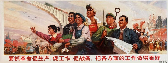
Cultural Revolution Era (1966 - 1976 AD) Poster: Uphold the Revolution, increase productivity. Promote preparation for war. Do even better on all fronts !
the less than basic facilities and its primitive people, retired soldiers, and most of all; the newly condemned of the mass terror campaigns that had immediatly been unleashed on the Chinese populace itself by the completely ruthless Communist Party.
A never mentioned fact about Xinjiang was that it was a favorite place to send politically
condemned prisoners, who -considered useless for their minds, but still usefull for their body and labor- did the rough work of constructing roads, dams and irrigation works that would enable to further colonization of the territories in the West, up to then virtually uniquely inhabited by ethnic groups other than the Han Chinese. The first such prisoner groups and colonist arrived in the year 1950, but in consecutive decades, various waves of migrants would flood the region of Xinjiang, being sent voluntarily or involuntarily there to do both the dirty work for the larger Nation and be out of the way for the Central leadership.
Although most westerners mistakenly think that the first migrants and political repression arrived with the students who were sent down to countryside in the Cultural Revolution, in fact the colonization plans were unfolded for Xinjiang and other disputed regions such as Korea, Mongolia, Manchuria (which is not Chinese) and Tibet much earlier.
As a result, over the years many Chinese arrived in Xinjiang, gradually phasing out the native population from the best positions. The only reasons why Ethnic Minorities still dominate street life (albeit not society) in Turpan is that it is the hottest location in the entire Peoples Republic, whereas in addition there is nothing much to find there other than a limited opportunity for agriculture. And, indeed, there is another reason for the relative impopularity of supposedly scenic Turpan among Chinese immigrants.
Although an unpopular subject among Chinese tour operators, it may be noted that in the 1960s and 70s the town of Turpan lay near ground zero of all Chinese nuclear test, a total of 46 in all, many of whom were athmospheric detonations. The magnitude of later explosions was so great the shook the earth as had quakes for many millenia and the
A Full and complete Map of China (PRC) identifying all Language Areas big and small in all Provinces and Autonomous Regions of China.
Map includes Turkic Languages (Uygur, Kazakh, Kirghiz, Salar & Uzbek), Mongolian Language and Sub-Divisions (Mongol, Tu, Daur and Dongxian), Tungusic Peoples (Oroqen, Evenki and Xibe) and Languages, Korean, Tajik (Tadzhik), Mon-Khmer (Kawa + Puman (or Pulang)), Hui, Uygur (Uighur), Tibeto-Bhurman Languages, Tai and Miao, Yao and She' Language Area's and Borders. Main Area's and sub-divisions of Han Languages (Northern Mandarin, Eastern Mandarin, South-Western Mandarin and Cantonese) further included. This color-coded ethno-linguistic Map (of 1967 AD) identifies at a glance most ethnic minority regions in China
Map China Ethno-Linguistic / Language Distribution China