Introduction to Lop Nor & Malan Nuclear test Facility
Shihezi City & Area Maps
LOP NOR SALT LAKE & MALAN NUCLEAR TESTING RANGE :
A somewhat famous region of interest within the Xinjiang-Uighur Autonomous Region is the Lop Nor, in the last two millennia a large lake surrounded by extensive marshlands, which is today a dried up and salty desert depression situated directly between the Taklamakan Desert and the even larger Gobi Desert to the East. This now mostly abandoned and more-over barren region is well known for its crucial historic importance and relevance to China's economical, social and cultural development and its contacts with Central Asia and the world as the Lop Nor, an Oasis Lake along the Silk Road.
Source Book
"Tracing Marco Polo's Northern Route"
( available from our Online Store )
The beautiful Photo-Journey of Wang Miao and Shi Baoxiu, all the way from the Pamir Highlands in Central Asia, through North China to Beijing along the Silk Northern Route. A jewel of a Book !!
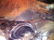
China Report - View o/t Tarim River Delta - Lop Nor dried lake area in Xinjiang AR
MALAN NUCLEAR TESTING RANGE :
The Malan nuclear testing range is no longer a secret facility. However, at the time of its official opening in 1959 AD it was location of the highest possible secrecy. Among things base workers were not allowed to inform their relatives of their whereabouts, nor of their specific task. Communications were virtually non-existant, highly controlled by the scret service and police and all the scientific workers and support teams operated in absolute seclusion and under primitive circumstances to succeed in their given goals. The goal of the time was to achieve a Chinese nuclear bomb capability, as we know in hindsight, at virtually any price that needed to be payed.
In other words, the nation knew nothing of the Malan Base and it would not for a long time.
According to modern historic sources, the location of Malan was chosen for military purposes on the 21st November of 1958, upon the recommedation of Soviet advisers who had done joint surveys of several areas (their criteria for the choice remain undiscussed). Today it is known that between 1964 and 1996, China conducted 45 nuclear tests at the Malan facility and nearby at Lop Nor.
The headquarters of the huge nuclear test base is in Malan, about 125 km northwest of Qinggir, hence the name given to the facility. However the base is much larger and not tied to this one location at all.
Today, the Malan test-site, taken at its largest circumference including Lop Nor (test site), is the world's largest such Facility, occupying an area of over 100,000 sq km. According to various sources the Malan testing grounds include over 2,000 km of highways. Commercial satellite imagery (available online) shows that around 20,000 sq km have been used for various forms of nuclear testing. The current Malan test Facility contains four testing zones situated within the Lop Nor Lake Bed depression. Three of these testing zones have been used for underground testing and one facility (the earliest one) was used for several atmospheric nuclear tests. The last atmospheric blast occured at Lop Nor on October the 16th of 1980.
Only two of the nuclear testing zones, together occupying an area of about 200 sq km, are currently seeing activity.
Apart from being the site of various historicly important events relating to China's nuclear history, today Malan is still operational as the main location for China's nuclear weapons training.
As rumoured but not confirmed, the Malan site is also held to be a location of a nuclear weapons stockpile. Already in 1993 to 96 renowned research agencies such as "Jane's Intelligence Review" determined that Lop Nur is a likely site for interim high-level waste (HLW) storage and an eventual repository.
Rumor also has it that sections of this large base have been used as a nuclear dumping ground.
Much changed in China during Mao Zedong Era, and regardless of its extremely remote location, change came to the Lop Nor and area as well. In fact, at the time, exactly the remote location and lack of population density around the long empty lake became the main attraction of this spot for the next set of events that would bring it more fame. Or notoriety at least.
Starting in the 1950's, the Lop Nor was used for altogether very different purposes than giving and sustaining life. The former Lake Bed, historic place turned empty desert, was judged to be the ideal, secret and ultra-remote, out of the public eye, testing ground for China's self-developed nuclear weapons (and their ballistic missile delivery systems). Possible other notable factors, less easily explained, (may have) weighed in as well. That is, firstly, the Lop Nor, technically and historically lies just outside of what has always been regarded as ″True″ Chinese territory, aka the border of historic Chinese heartland (Illustrated by the construction of the Yumen (guan) - Jade Gate (pass)Toll House during the Tang Dynasty (618 AD - 907 AD) outside of Dunhuang and due East of Lop Nor Lake, and again -less accurately- by ending of the Great Wall of China at Jiayuguan during the Ming Dynasty (1368 AD - 1644 AD).) Thus, as will have been due registered by a person which such historical awareness as Mao Zedong, the Lop Nor historically) was not considered part of China. A good place to, as Mao Zedong may have put it, let out a giant fart.
Furthermore, secondary to the remoteness, the climate and other factors explained, most of the inhabitants of the region are not of Han ethnicity. Thus, they may have been considered as not really Chinese, and given the frame of mind of the days, been considered as fairly expandable.
Whatever the considerations may have been in reality, the Lop Nor regions were chosen to be used for secretive military purposes and soon a variety of nuclear facilities was set up at- , in- and around the Lop Nor region.
In the following 20 to 30 years virtually no one in China knew about the existence of any of these basis and outside of China but a few people were aware. The Lop Nor nuclear facilities and other supporting bases were however no longer a total secret due to mainly secret overflights by U2 Spy Planes. The United States of America was already attempting to spy on the bases, and naturally, being involved with the early founding of the Chinese nuclear program and work on the ground, the Soviet Union had a fairly good hunch where the base was to be found.
In 1964 AD, under the careful monitoring of both the Soviet Union and the United States, the Lop Nor became the nuclear testing site where China detonated its first nuclear weapon.
This first Chinese nuclear explosion, dubbed project 59-6 in the West ,was an atmospheric blast which occured not inside the Lop Nor lake basin but at a site further eastward in the (Inner-Mongolian desert).
The first nuclear detonation that occurred in the lake bed itself (Malan Base) was achieved during the 3rd Chinese Nuclear test, which (according to U.S. information) occured on May 9 of 1966 AD. This test, dubbed CHIC-3 by United States Intelligence, consisted of an Atmospheric Test of an air-dropped bomb of the layered cake design derived from the soviet union.
The bomb was caried aloft by a soviet built bomber adapted for the task and subsequently dropped in the Lop Nur area of Xinjiang yielding a massive 250 kiloton explosion.
While the explosion left a giant mushroom cloud hovering over western China, the event was great news in Beijing. Again, on Mao's express orders, the scientists of Malan, and Jiuquan (Dongfeng) Base in neighboring Gansu Province, together with several Chinese Universities around the nation had succeeded in making dramatic progress. It was an unprecedented blast and China could be secure in its rise as one of the worlds nuclear armed nations. As many saw it, finally the nation would be able to withstand any 'Imperialist' outside force, forces that had so wreaked havoc on the nation in the previous 100 years.
Many more Chinese nuclear test followed, mostly at Lop Nor and adjoining regions of Xinjiang until the unilateral compliance of China (P.R.C.) with the nuclear test ban treaty ratified in 1996 AD).
Although the Cold War, Mao Zedong's tyranny and the days of absolute secrecy are long over and some of the secret sites of National Security have even been opened as tourist attractions, much of the Lop Nor desert remains off limits, meaning that they are considered a restricted military zone, and a number of unidentified military facilities remain in this area. Together the most prominent of these are known internationally as the Malan Secret Nuclear Testing Facility.
Historically the Lop Nor was known as a crucial stop over point on the so called ″Silk Road″, a network of trading routes that came into existance at around the 2nd and 1st Century B.C. and, when in due course of time further developed, connected China with Central Asia, and Africa, Arabia and Europe beyond. Fed by China's 5th largest River, the Tarim, the Lake Lop Nor was a refreshing and life giving lake of a fairly substantial size with sweet waters and rich in fish, bird and game that, together with the river formed the basis of what is known as the Northern Route of the Silk Road (within China).
As a fresh water lake surrounded on two sides by vast desertlike regions, the Lop Nor formed as it were, a watery bridge between two worlds. Without the lake (and the River), no Silk Road would have existed, or at least not in this region.
To the West of the Lake lay the road into Central Asian lands (territories that are now known as Kazakhstan, Kyrgyzstan, Tajikistan, Afghanistan and Uzbekistan) - harsh journey filled with many dangers the first of which was the huge taklamakan (never returning) desert-, and to the East of the Lake lay the road to the Chinese Border and the protection that it offered, however still 8 to 14 days traveling through inhospitably, dry and sandy expanses of the Gobi Desert. In between was the lake, a wonderful green world within itself. It thus became famous in the tales and recorded writings of silk road travelers, all of whom longed to be in safety and in abundance at the shore of the blue Lop Nor Lake.
As a watery conduit or pillar of the Silk Road, naturally the Lop Nor saw its fair share of travelers,
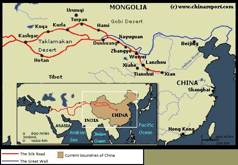
A schematic geographic Map depicting the main pathway of the Silk Road, connecting China with Central Asia and vice versa. Marked on the Map is the location of Lop Nor Lake, of obvious strategic importance in historic terms.
among whom some who became famous and sometimes left records of its existance and the life of the people and civilization(s) that grew and fell along its shorelines.
To name but a few, the famous Monk Xuanzhang (629 AD - 645 AD) who brought Buddhist knowledge from India, thus becoming the Chief Religious Teacher (Shi Fu) at the famous Great Goose Pagoda in Xi'an (Chang'An), a renowned Chinese Cultural attraction in itself, camped along the shoreline of the Lop Nor, as did several centuries later the now well-known European traveler Marco Polo. As a result, the name of Lop Nor resounded far beyond merely the regions, or China alone.
Many centuries later, the name of Lop Nor once again rose to prominence as the result of extensive and often uninvited explorations of the wider regions, as well as the Silk Road monuments, mainly by European explorers.
During the 19Th Century and early 20th century, several now famous explorers made their name by making their discoveries in what today is Xinjiang-Uighur Autonomous Region, the Taklamakan Desert and around the Lop Nor Lake. The earliest arriving explorers were the Russians, who sent at least five exploring missions in succession and left extensive and acurate (military type) maps which later helped prepare for what amounted to a Russian Invasion. Later arriving European explorers who traversed the Xinjiang Region (New territories ; also East Turkestan) were British and Americans who, apart from recording the geographical features of the local terrain went on the search for ancient and historic cultural relics. The volume of information left after the work of these several waves of explorers concerning the Lop Nor is clearly to large to sum up in this text, however it may be noted that through their works the name of Lop Nor was communicated around the Globe. Especially the reports of Swedish Explorer Sven
Hedin, who - against impossible odds and on the verge of a thirsty death- relocated and rediscovered the Lake in 1900 AD, finding it nearly dried out, did much to inspire public imagination around the Globe. Although mass tourism was invented and fully developed only half a century later, it was from that moment that the remote Lop Nor became a worthy historic location and thus a site of tourist interest. It still is today, regardless of its state.
Further historic archeological finds done along the trajectory of the Silk Road near Lop Nor by Sven Hedin, Sir Marcus Aurel Stein and less famous others have further inspired many around the globe. Names of locations such as the Lost City of Miran - refound by Sven Hedin along the rim of empty Lop Nor, and the forgotten Buddhist Kingdom of Loulan from which Aurel Stein took away priceless relics that later proved to have recorded major historical events that occured along the Silk Road have become standard knowledge for Silk Road fans and historians since their first publication.
Much due to its extremely remote location, and furthermore a long period of political instability in China, little is known about the Lop Nor during the first half of the 20Th Century. What is clear is that the Lake Lop, although found refilled in the year 1910 AD, again lost its waters thereafter. As a result, the once green oasis in Xinjiang (and neighboring Gansu) progressively shrank and the already sparse population trickled away to places of better living. Since the advent of the Peoples Republic of China (P.R.C.) the Lake Lop, Lop Nor) has mainly be known a desert rather than a Lake. It is recorded that in the 1990's, when a large scale Government scheme was launched to refill the Tarim River (and thus theoretically parts of the Lop Nor), the once famous Oasis towns of Khotan and Cherchen had reverted to dust blown towns, threatened to be overrun by the desert sand, inhabted mainly by the hopeless or patient who had remained behind. All other, especially the young had left the parched grounds in search of a better life.