Keriya Climate & Weather :
Keriya Basic Knowledge :
Hotels in Keriya (Mugala) Town & County
There are currently no direct Hotel Booking options available for in Keriya (Mugala) County Town. For nearest Hotel and Lodging please refer to: Hotels in Hotan,
or hit below Button.
Ethnic Minorities of Keriya & Area
Keriya (Mugala) Town & County Today
History of Keriya (Mugala)
Keriya Town & County Maps
To The China Report Main Menu
This page was last updated on: June 18, 2017
Keriya (Mugala) Report
Introduction to Keriya (Mugala - 木尕拉镇 ; كېرىيە )
Keriya (Mugala) Landmarks & Monuments
Keriya (Niya) is a remote provincial Town in the south-west of the Tarim River Basin of West-China's Xinjiang-Uygur Autonomous Region. It is part of the Khotan Prefecture.
It is an ancient Silk Road Oasis City with a Long History.
Go to www.drben.net webring
Re-explore the Silk Route today and find the treasures of yesterdays long past ..
Source Book
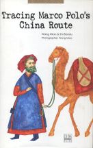
"Tracing Marco Polo's Northern Route"
( available from our Online Store )
The beautiful Photo-Journey of Wang Miao and Shi Baoxiu, all the way from the Pamir Highlands in Central Asia, through North China to Beijing along the Silk Northern Route. A jewel of a Book !!
To Main Menu of All Websites at DrBen.Net
ChinaReport.com at
Alphabetically ordered list of Monuments, Landmarks and other sites of interest in and around Minfeng (Niya)
A Full listing of Keriya Town Landmarks, Monuments, Hotspots and other sites of importance in alphabetical order. Search through the list to find your Full Report and Photo-Virtual Tour of each monument or landmark within the City, or Region of Keriya (Mugala) in Khotan Prefecture of Xinjiang-Uygur AR of China (PRC).
Keriya Public Transport
All available Maps of Xinjiang-Uighur Autonomous Region !
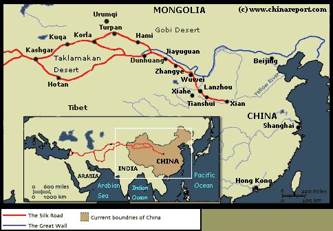
There are no railroads along the Southern rim of the Tarim River Basin and the Taklamakan Desert. Therefor, Keriya (Mugala) has no Railway Station. Currently, the nearest train station is found in Hotan City. This is the end station of what is the Kashgar to Hotan Railway. In the future the line may however be extended due to apparent Government plans for the development of infrastructure in Keriya (Yutian) and County.
Main Airfield at Hotan in Hotan City Prefecture - More information
Complete Listing of available Hotels in Keriya (Mugala), Khotan Prefecture, Xinjiang AR, China (PRC).
Click to go to Full Version Han Dynasty Empire & Connections Map !!
Main Airfield at Kashgar - More information
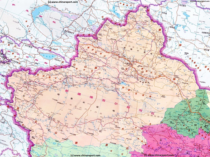
There are no maps available of Keriya (Mugala) and immediate vicinity.
For all Maps of Xinjiang-Uighur Autonomous Region, please refer to: Xinjiang Maps Index.
No information available.
There is no information available on the Ethnic Minority groups residing in or near Keriya.
There is no information available on life in Keriya as it is today.
There is no information available on Climate and weather in Keriya (Mugala).
Tweets by @ChinaReportcom1
Follow and Respond to us on Twitter :
This page was last updated on: June 18, 2017
My Great Web page
Click Map to go to Full Version !!
Yarkand
Koktogai
Altay
Changji
Barkol
Kizilsu
Qilian Mts.
Chowd
Altai
   Mts.
Keriya
Niya
Khovd
Olgii
Mörön
Kashgar
Aksu
Hotan
Turpan
Korla
Karamay
Hami
Urumqi
Ulungur River
Kashgar
River
A (dated) Goegraphic Map of Xinjiang-Uyghur Autonomous Region with its main population centers, roads and railroad, connections, airports, and main geographical features.
- CLICK MAP TO GO TO FULL VERSION !!! -
Karamay, Karamay Prefecture, Xinjiang Uighur Autonomous Region, China (P.R.C.).
Jinghe'
Manas Lake
Urumqi, Capital of Xinjiang-Uygur AR
Turpan (Turfan), Turpan Prefecture, Xinjiang Uighur Autonomous Region, China (P.R.C.).
Hami (Kumul), Hami Prefecture, Xinjiang Uighur Autonomous Region, China (P.R.C.).
Kashgar, Kashgar Prefecture, Xinjiang Uighur Autonomous Region, China (P.R.C.).
Korla
Ulungur Lake
Bosten Lake
Tarim River
Lop Nor
Salt Lake
Yarkant
River
Hotan
River
Kheriya
River
Cherchen
River
Niya
River
Yarkand (Shache), Yarkand (Shache) County, Kashgar Prefecture, Xinjiang-Uyghur Autonomous Region, China (P.R.C.).
Niya (Minfeng), Khotan Prefecture, Xinjiang Uighur Autonomous Region, China (P.R.C.).
Hetian (Hotan or Khotan), Hotan Prefecture, Xinjiang Uighur Autonomous Region, China (P.R.C.).
Cherchen
Cherchen, Bayin-Gholin Mongol Autonomous Prefecture, Xinjiang Uighur Autonomous Region, China (P.R.C.).
Ili
River
Jinghe
Aksu, Aksu Prefecture, Xinjiang Uighur Autonomous Region, China (P.R.C.).
Yining
Yining - Kulju (Gulja), Ili-Kazakh Autonomous Prefecture, Xinjiang Uighur Autonomous Region, China (P.R.C.).
Mongolia
Khovd, also: Khobdo (Mongolian: Ховд), Capital of Khovd Aimag, Republic of Mongolia.
Olgii (Өлгий cradle), Capital of Bayan Olgii Aimag, Republic of Mongolia.
Mörön (Mongolian: Мөрөн), Capital of Khövsgöl Aimag, Republic of Mongolia.
Altai (), Capital of govi-Altai Aimag, Republic of Mongolia.
Altai
Keriya (Mugala), Khotan Prefecture, Xinjiang Uighur Autonomous Region, China (P.R.C.).
Tian Shan Mountains
Altai
   Mts.
Altyn Tagh Mts.
Kunlun Mts.
Taklamakan Desert
Lop Nor Desert
Balkash Lake
Dzungar Depression
Ruoqiang
Ruoqiang (Charkliq), Bayin-Gholin Mongol Autonomous Prefecture, Xinjiang Uighur Autonomous Region, China (P.R.C.).
Tibet
Tibet
Gansu
Kazakhstan
Kyrgyzstan
Russia Fd.
Ili-Kazakh
Qinghai
Tax-
Kor
-gan
Kashmir
Kara-
koram
  Mts.
Pakistan
India
Tajiki-
Stan
Changji, Changji Hui Autonomous Prefecture, Xinjiang Uighur Autonomous Region, China (P.R.C.).
Altay,  Altay Prefecture, Xinjiang Uighur Autonomous Region, China (P.R.C.).
The China Report
The Hetien ((K)Hotan) Report is part of the overall website www.ChinaReport.com & www.drben.net
Learn about what is new on this Site from below window.
Hi! from Doc Ben and Proud Staff
Click to Go to Large Scale Map 1A
Find DrBen and ChinaReport on Facebook with the latest from www.drben.net.
DrBen Nijhoff | Maak je eigen badge
Hotan
Hetian (Hotan or Khotan), Hotan Prefecture, Xinjiang Uighur Autonomous Region, China (P.R.C.).
Google supported Map of Keriya and County in Khotan Prefecture of Xinjiang Uighur Autonomous Region (P.R.C.), by AsiaReport.com

AsiaReport.com - Mastermap of Asia (entire). weergeven op een grotere kaart
Tweets about "#Xinjiang"
Xinjiang Sources
Xinjiang AR
Urumqi
Urumqi Home
Urumqi Hotels
Xinjiang AR Home
Kashgar (Kashi)
Kashgar Home
China Offline Sources
AsiaReport.com Home
China Report Home
China Online Sources
China Online Store
China Maps
China
China Photo Galleries
China Report Club
Tashkurgan Tajik A.C.
Hotan
Hotan Home
Turpan
Hami Home
Karamay
Karamay Home
Aksu
Aksu Home
Altay
Altay Home
Autonom. Pref.
Bayin-Gholin - Shihezi
Changji (Hui) & Changji
Ili-Kazakh - Yining Home
Kizilsu Kyrgyz - Artux
Turpan Home
Hami (Kumul)
Xinjiang Hotels
Xinjiang History
Xinjiang Monuments
Xinjiang Maps
Xinjiang Minorities
Xinjiang Transport
Xinjiang Wildlife
Xinjiang Economy
Xinjiang Geography
Rivers & Lakes
Hotan History
Hotan Monuments
Hotan Maps
Full Map of Transportation options in Asia, China and Mongolia. - Intl. Airports, Airports,Train Stations.
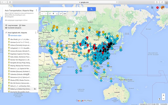
Asia China Mongolia Transportation - Airports & Railroads Satellite Map
This Satellite Image provides an overview of all International Airports in Asia, all Airports in China (PRC) and Mongolia. In addition all military airbases in China (PRC) listed.
Navigate map and click pins for additional information and video where available. Link through from any pin to location information and backgrounds.
Overview all transportation in the Peoples Republic of China and additional Asian Nations in one glance.
Direct Hotel & Resort booking + additional packages linked by location across China, Mongolia and neighboring Asian Nations.
Notably on June 17 of 2017 the Chinese Government announced that the green light had been given for the construction of an airport at Keriya Town. This would make Keriya the second town in Hotan City Prefecture to have an airport. In the official press released announcement no details were given for the exact geographic location of the airport. The new Yutian Airport is to be one of 10 new airports to be built in addition to the 18 that are already available in the restive Xinjiang-Uighur Autonomous Region. The new planned airport is to have a single 3200 meter runway and a passenger terminal of some 3000 square meters, in addition 4 aprons, a control tower, water- and fuel storage facilties, which is a standard configuration for a minor out of the way civilian airport but also for a standard Chinese fighter aircraft base.
No military plans have been announced for the Yutian Airport but it will certainly be able to serve a dual use function. All new airports in Xinjiang are to be completed by the year 2020 bringing the total number up to 28.

Currently, the nearest Airport is Hotan Airport at a distance of some 200 kilometers due west.

Inferring from the above, one may find that currently the only way to travel to and from Keriya is by road. In doing so you are likely to retarce parts of the notorious routes taken in previous centuries by the famed silk road travelers who made the name of Keriya (Mugala or Yutian) Great and unforgattable, especially in relation to the history of the historic silk road in (western) China.