To The China Report Main Menu
This page was last updated on: June 4, 2017
The Hotan Report
History of Hotan (خوتەن شەھىرى ; 和田市)
Go to www.drben.net webring
To Main Menu of All Websites at DrBen.Net
ChinaReport.com at
Find DrBen and ChinaReport on Facebook with the latest from www.drben.net.
DrBen Nijhoff | Maak je eigen badge
Tweets by @ChinaReportcom1
Follow and Respond to us on Twitter :
This page was last updated on: June 4, 2017
My Great Web page
Khotan in the Han Dynasty :
History of Khotan:
No information available.

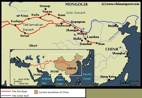
Turpan - Turpan in Xinjiang-Uygur was under Chinese Control by 90 AD, at the very latest. Although incursions by vengeful Nomadic Tribes would threaten and conquer Kashgar and Turpan several Times, Turpan would return to Chinese Rule or Dominance. Today Turpan lies in Xinjiang Autonomous Region of China, due South-East of Urumqi.

In the morning of Feb 12 2004, a massive earthquake struck 12 kilometers (7.7 miles) under the surface at some 270 kilometers (170 miles) from the City Prefecture Level Town of Khotan. The quake was strongly felt by residents in Hotan, Yutian and Moyu.
Estimates of the severity of the earthquake ranged between 6.8 and 7.3 on the Richter scale. In the aftermath Chinese news outlets Xinhua and China Daily reported 67 houses had been toppled and another 1000 damaged without human casulaties, relying on reports by local authorities said.
In addition, it was reported that 185 livestock deaths were reported.

URUMQI- A 7.3-magnitude earthquake hit northwest China's Xinjiang Uygur autonomous region on Wednesday, according to the China Earthquake Networks Center (CENC).

The epicenter, with a depth of 12 km, is located at Yutian county in southwest Xinjiang, or about 36.1 degrees north latitude and 82.5 degrees east longitude.

Sections of railways were temporarily suspended in Xinjiang after the earthquake.

The railway administration of Urumqi suspended a section from Hotan to Moyu on the Kahe Railway, which links Kashgar and Hotan, for safety reasons, with a total of 531 passengers being stranded at Moyu. Service resumed at 6:52 p.m. after safety and security checks.

A total of 143 aftershocks had been monitored as of 8:00 p.m. Wednesday, with the biggest one measuring at 5.7-magnitude at 5:24 p.m. in the same area.

President Xi Jinping and Premier Li Keqiang ordered concerted effort to guarantee safety and property and issued instructions on relief work soon after the quake.

Local authorities and departments were urged to check disaster situations, conduct emergency management and strengthen seismic monitoring.

The Ministry of Civil Affairs and the National Commission for Disaster Reduction also initiated an emergency disaster relief response and dispatched a work team to check the disaster situation and direct rescue work.

The epicenter is in a sparsely populated area with an average altitude of 5,000 meters. It is more than 50 km away from the nearest settlement, Aqqan village in Yutian County, and more than 900 km away from the regional capital of Urumqi. The average altitude of the area within the scope of 30 km from the epicenter is about 5.1 km.

Local residents said the houses near the epicenter are all quake-resistant and nomads are less likely in the mountainous areas, where the epicenter is located, during winter. Xinjiang started a quake-resistant housing project in 2004.

Experts from the CENC said that the area shares the same plate with Wenchuan in southwest China's Sichuan Province and Yushu in northwest China's Qinghai Province.

Wenchuan was devastated by an 8.0-magnitude quake in 2008, and Yushu was hit by a 7.1-magnitude quake in 2010.
Find out the Details in the History of Khotan
Click Map to go to Full Version !!
Yarkand
Koktogai
Altay
Changji
Barkol
Kizilsu
Qilian Mts.
Chowd
Altai
   Mts.
Keriya
Niya
Khovd
Olgii
Mörön
Kashgar
Aksu
Hotan
Turpan
Korla
Karamay
Hami
Urumqi
Ulungur River
Kashgar
River
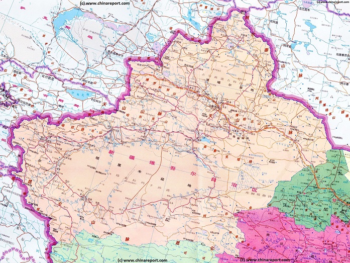
A (dated) Goegraphic Map of Xinjiang-Uyghur Autonomous Region with its main population centers, roads and railroad, connections, airports, and main geographical features.
- CLICK MAP TO GO TO FULL VERSION !!! -
Karamay, Karamay Prefecture, Xinjiang Uighur Autonomous Region, China (P.R.C.).
Jinghe'
Manas Lake
Urumqi, Capital of Xinjiang-Uygur AR
Turpan (Turfan), Turpan Prefecture, Xinjiang Uighur Autonomous Region, China (P.R.C.).
Hami (Kumul), Hami Prefecture, Xinjiang Uighur Autonomous Region, China (P.R.C.).
Kashgar, Kashgar Prefecture, Xinjiang Uighur Autonomous Region, China (P.R.C.).
Korla
Ulungur Lake
Bosten Lake
Tarim River
Lop Nor
Salt Lake
Yarkant
River
Hotan
River
Kheriya
River
Cherchen
River
Niya
River
Yarkand (Shache), Yarkand (Shache) County, Kashgar Prefecture, Xinjiang-Uyghur Autonomous Region, China (P.R.C.).
Niya (Minfeng), Khotan Prefecture, Xinjiang Uighur Autonomous Region, China (P.R.C.).
Hetian (Hotan or Khotan), Hotan Prefecture, Xinjiang Uighur Autonomous Region, China (P.R.C.).
Cherchen
Cherchen, Bayin-Gholin Mongol Autonomous Prefecture, Xinjiang Uighur Autonomous Region, China (P.R.C.).
Ili
River
Jinghe
Aksu, Aksu Prefecture, Xinjiang Uighur Autonomous Region, China (P.R.C.).
Yining
Yining - Kulju (Gulja), Ili-Kazakh Autonomous Prefecture, Xinjiang Uighur Autonomous Region, China (P.R.C.).
Mongolia
Khovd, also: Khobdo (Mongolian: Ховд), Capital of Khovd Aimag, Republic of Mongolia.
Olgii (Өлгий cradle), Capital of Bayan Olgii Aimag, Republic of Mongolia.
Mörön (Mongolian: Мөрөн), Capital of Khövsgöl Aimag, Republic of Mongolia.
Altai (), Capital of govi-Altai Aimag, Republic of Mongolia.
Altai
Keriya (Mugala), Khotan Prefecture, Xinjiang Uighur Autonomous Region, China (P.R.C.).
Tian Shan Mountains
Altai
   Mts.
Altyn Tagh Mts.
Kunlun Mts.
Taklamakan Desert
Lop Nor Desert
Balkash Lake
Dzungar Depression
Ruoqiang
Ruoqiang (Charkliq), Bayin-Gholin Mongol Autonomous Prefecture, Xinjiang Uighur Autonomous Region, China (P.R.C.).
Tibet
Tibet
Gansu
Kazakhstan
Kyrgyzstan
Russia Fd.
Ili-Kazakh
Qinghai
Tax-
Kor
-gan
Kashmir
Kara-
koram
  Mts.
Pakistan
India
Tajiki-
Stan
Changji, Changji Hui Autonomous Prefecture, Xinjiang Uighur Autonomous Region, China (P.R.C.).
Altay,  Altay Prefecture, Xinjiang Uighur Autonomous Region, China (P.R.C.).
The China Report
The Hotan (Hetian) Report is part of the overall website www.ChinaReport.com & www.drben.net
Learn about what is new on this Site from below window.
Hi! from Doc Ben and Proud Staff
Google supported Map of Hetien (Khotan) in Hotan Prefecture of Xinjiang Uighur Autonomous Region (P.R.C.), by AsiaReport.com

AsiaReport.com - Mastermap of Asia (entire). weergeven op een grotere kaart
Wuwei (Gansu Province)
Zhangye (Gansu Province)
Tianshui (Gansu Province)
Lanzhou (Gansu Province)
Xi'An (Shaanxi Province)
Dunhuang (Gansu Province)
Jiayuguan (Gansu Province)
Kashgar (Kashi) Xinjiang-Uygur Autonomous Region
Urumqi (Kashi) Xinjiang-Uygur Autonomous Region
Beijing (City Province)
Shanghai (City Province)
Hong Kong (Special Administrative Region)
Hami (Kumul), Xinjiang-Uygur Autonomous Region
Hetian (Hotan), Xinjiang-Uygur Autonomous Region
Turpan (Turfan), Xinjiang-Uygur Autonomous Region
Helpful schematic map showing the position of Xian relative to the coastal cities, the current National Capital and the ancient silk road extending from Xian westwards into the west and Central Asia beyond.
Xinjiang Sources
Xinjiang AR
Urumqi
Urumqi Home
Urumqi Hotels
Xinjiang AR Home
Kashgar (Kashi)
Kashgar Home
China Offline Sources
AsiaReport.com Home
China Report Home
China Online Sources
China Online Store
China Maps
China
China Photo Galleries
China Report Club
Tashkurgan Tajik A.C.
Hotan
Hotan Home
Turpan
Hami Home
Karamay
Karamay Home
Aksu
Aksu Home
Altay
Altay Home
Autonom. Pref.
Bayin-Gholin - Shihezi
Changji (Hui) & Changji
Ili-Kazakh - Yining Home
Kizilsu Kyrgyz - Artux
Turpan Home
Hami (Kumul)
Xinjiang Hotels
Xinjiang History
Xinjiang Monuments
Xinjiang Maps
Xinjiang Minorities
Xinjiang Transport
Xinjiang Wildlife
Xinjiang Economy
Xinjiang Geography
Rivers & Lakes
Hotan History
Hotan Monuments
Hotan Maps