History of Qinghai (青海) Province of China / East Tibet (1)
Qinghai Province is a Chinese Region with a unique history as it was only absorbed into The Peoples Republic of China in 1959 AD. Until 1950 AD, when a Chinese Military campaign into East Tibet took place, Qinghai Province and Tibet Autonomous Region did not factually exist other than as an inseperable part of the Tibetan Region and The Nation of Tibet.
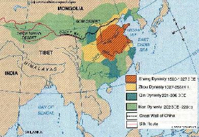
As can be easily deduced from the adjacent Map, the official history of Han Civilization started out with the Shang Dynasty (1766 BC - 1121 BC), with 'cities' developing in the lower regions of the Yellow River, at quite some distance from Tibet and the Himalayas. First sporadic contacts with the Tibetans were likely made earlier, but the first cooperation, trade and communications started in earnest during the Zhou Dynasty (1040 BC 256 BC) as by the Time of the Warring States Period (475 BC - 221 BC), Lanzhou (today in neighboring Gansu Province) near the border of Tibet had become a Han Chinese military fortress and a Taoist
This page was last updated on: July 10, 2017
ChinaReport.comat
Qinghai Province of China
Urumqi
Kashgar
Apart from these issues as a background, Tibet Autonomous Region and especially Eastern Tibet (Qinghai Province + Sichuan Province) have a rich and long history in connection with the Han Peoples and other peoples of the Region through the Silk Road and other trading paths of the wider region. Contacts ran South to Burma and India, as well as westward with the many nomadic Peoples of Central Asia.
First contacts with the Han were established very early during the Warring States Period but were further developed after the rise of China during the Qi'In Dynasty (221 BC - 206 BC) and succeeding Han Dynasty (206 BC - 221 AD). As the Han Dynasty's Chronicles record, among the first commodities traded from Qinghai was its abundant salt. During the Western Han Dynasty Era the salts derived from the Tibetan Plateaux were bought by the Han and then transported and sold to the Capital of Chang'An (Xi'An) and surrounding territories, today Shaanxi Province, Shanxi Province and Gansu Province. From that period onwards the salt-trade which linked the Tibetan Plateaux with the Chinese heartlands grew wider. It would go a bit too far to discuss the developments in detail but
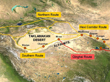
Schematic depiction of the main pathways o/t silk road passing along the north-rim of the Giant Tibetan Plateaux and the secondary path bypassing the Hexi Corridor through Xining.
As stipulated by the Government of the Peoples Republic of China in the Section 'Tibet as an inseparable part of China' part of the document 'Tibet - The 'Roof of the World', from the series China - Facts & Figures ; ISBN: 7-119-01259-2 / Z502 and Published by Beijing Foreign Language Press (BFL) in 1990 AD, Beijing :
"Historical changes and Development
China is a united multi-ethnic country that has been formed through longstanding cooperation between Hans and Tibetans, Mongolians, Uygurs and many other nationalities. Friendly contacts between the Tibetan People and the people of other nationalities, mainly Han, began long ago.
In the early 7Th Century, Tibetan National hero Songtsen Gampo unified Tibet and founded the Tufan Regime, with Lhasa as the capital. Songtsen Gampo paid great attention to the advanced production technologies and outstanding political and cultural achievements of the Han People and sent envoys to the Tang Dynasty Emperors to seek marriage alliance.
In 641 AD Emperor Taizong sent special envoys to escort Princess Wen Cheng to Tibet to marry Songtsen Gampo. Then the Tang Emperor sent a large number of Han craftsmen to Tibet, which promoted the development and the economy and culture of Tibet."
(The Tang Military Missions on the Silk Road were not exclusively reserved to this path of the Silk Road, however. Apart from this main and northern route, there were several other connections. In fact, trade routes lay as a web across Central Asia connecting the various cities through multiple parallel pathways.
Hence. the Tang set to work on securing and controlling these as well.
Around 634 AD, South Gansu Province, the Qinghai Eastern Part of the Tibetan Plateaux (including Gansu and current day Qinghai Province) was subdued by advancing Han Armies. Next in the line of the rolling Tang Military Machine were the Peoples of Tibet who had only recently been unified under the Rule of Songtsan Gampo.
Map of Eastern Asia showing the Territories of the first successive Dynasties in Han China up to 220 AD.
place of Pilgrimmage as well. While the Han Chinese Nation was united for the first time under the tyrannical dictatorship of Q'In Shi Huangdi (221 BC - 206 BC) and successively became expansionist under the Han Dynasty (206 BC - 220 AD) the Tibetan population still lived in division, basically each Tribe residing in and fighting for their own valley and region. At the Time there was no Tibetan Nation, only the geographically circumscript Region of the Tibetan Plateaux, the roof of the World.
from the initial long-distance trade and many hardships grew a nation-wide business Empire and distrubution network. Usually, the monopoly on this rich trade was claimed by the Chinese State apparatus (although smuggling and independent trade would always co-exist in some form) which then relegated (sold) the task to a selected few wealthy trading companies. For this reason, as trading practices developed and matured, the Trade was mainly in the hands of People from Shanxi Province (See: History of Shanxi Province), who helped extend trading contacts into remote and underdeveloped regions of Mongolia, Tibet, The Hexi Corridor and Xinjiang. Much later, after the fall of the Mongol Empire, the Shanxi Bankers often went in front of the Chinese Armies, and followed after, forming the economic arm of Chinese influence and expansion.
Naturally, at first this north-western corner of the Tibetan Plateaux was a new Frontier. For long this out of the way corner would beknown as a place "Beyond-the-Great-Wall". At first, the quantities of Salt traded were only small and only the rich upper-class could afford to buy this salt for their own consumption. Other uses were medicinal or cultural, the precious salt to be given as present to a friend or important relation. (It is still tradition in many places of the Northwest to send salt and tea as presents to friends). The hardships involved in the trade were monumental. However, it was an important and lucrative trade which in time increased Han interest in the Regions and helped develop the trade routes of Central Asia.
As for the Salt of Qinghai, one of the famous sources of the Han Dynasty Salt was the so-called Chaka salt lake which largely consists of crude salt which contains more than 96% sodium chloride with few impurities such as kalium and magnesium salts. As might be noted by your tour-guide whenever you visit the regions and may get a chance to try out the local cuisine, the local people have known for 1000's of years that vegetables pickled with this salt will last much longer and that dishes cooked with the salt are more delicious. Hence, the remote Chaka Lake, near Wulan in Haixi Mongol and Tibetan Autonomous Prefecture is still being mined today, and furthermore counts as a growingly popular though minor tourist destination of the regions.
During much of the Tang Dynasty Rule, the Tibetan heartlands were accessible through steep mountain passes from the South Route of the Silk Road out of the Taklamakan Desert, as well as from the newly conquered territories of Gansu and Qinghai. The Tibetan Territories held valuable Jade Sources and Salt for cooking and medicines. Even more importantly the valleys of Southern and North-Eastern Tibet held vital grazing lands needed for the many War Horses of the ever advancing and growing Tang Dynastic Armies. Tibet also held gold and silver and at a certain height in the fertile valleys around the rim of the high Tibetan Plateaux grew a unique plant, the tea plant. Tibet was the source of the tea plant, the cultivation and consumption of which had taken high flight, becoming yet another lucrative trade which had spread throughout the Han Chinese culture zone and which had quickly been turned into a cash commodity.
Hence, the Tibetan Peoples were to be included into the Tang Dynasty Empire by brute force.
This eventually opened up a new arm of the Silk Road, a Trade Route passing directly over and across the Himalayan Mountains through Tibet and Nepal to link up with North-India. This southern arm of the Silk Road would become a valuable source of Jades and other precious stones so loved by the Tang Culture. (Tibet however would be lost to the Tang and have its own Dynasty in 763 AD, however the Tang would regain control briefly in 851 AD only to lose out again.)
Next up, adding more trade road and therefor taxation rights to Tang Control were the Tribal States of Bhutan, Sikkim and what today is Nepal. This pacified nearly the entire Himalayan Mountains Area (except for Yunnan !), laying the Tang Borders and Defenses at the very outer passes, points easily defended against further invasion. Within flourished a booming Trade in both directions and many new ethnicities, cultures, beliefs and religions were included in this vast Empire.
In the same expansion South new area's in North Afghanistan including the Trading Cities of Balkh (Mazar-I-Sharif), Termez (named Thermos under Alexander the Great) and Kabul had been taken. Furthermore, in North Pakistan and on the North Border of current day Bangladesh further Tribal Area's and Kingdoms had been subdued. This was no small feat as this includes the Karakoram Pass, one of the highest mountain passes in the world. At the other side of the Mountains the City of Peshawar (Today in Pakistan's restive north western tribal regions bordering on Afghanistan), on the way into India came under Tang Military Rule. Notably, only
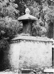
Conveniently forgotten by the Chinese Document is the Capture of the Tang Imperial capital of Chang'an (Xi'An) in 763 AD by Tibetan Troops. The City was only briefly occupied and spared ruin because of the Peace Treaty that was signed between the Tang Court and the Tibetans. As can still be found written on a Stele (the so-called Shol Doring) in front of the Potala Palace in Lhasa, at the Time the Han Chinese promised to pay a yearly Tribute of 50.000 bales of Silk to Tibet. Or else.
In Fact, this Stele is only one of three such Edicts eventually signed by the Tang Court.
Regardless of the First Edict and the near sacking of Chang'An, anymosity remained high and so not much later in 765 AD, Chang'an was once more besieged, however this time by an even bigger army brough together by the alliance of the Tibetans and the Uyghur Khaganate.
Tibet and China eventually agreed on the treaty of Ch'ing-shui in 783 AD, which established the boundary between the two countries as the Tatu (Dadu) River (in current day Yunnan Province); all land in the Kokonor region west of T'ao-chou was to be ceded to Tibet.
"In 821 and 822 AD the envoys of the two Governments met twice in Chang'An (present day Xi'An) and Lhasa to form an alliance and created a tablet that is still in front of Lhasa's Jokhang Monastery today. The inscription on the stele describes the friendship between the Han and the Tibetan People."
To be more correct: The Stele (Doring) originally erected in front of the Jokhang Temple indeed states that between the two nations “…the very world ‘enemy’ shall not be spoken”. It however contains a more important clause regarding the frontier (historically near the present Gansu-Shaanxi border) which makes clear that “All to the East is the country of Great China; and all to the West is, without question, the country of Great Tibet.” There are other translations which all come down to the same thing.
The Great significance of the Stele does not lie in the so-called Friendship' but in the fact that the agreement was reached after yet another Tibetan military Victory over the Tang Armies. It was basically a Tibetan Edict of Independence, or at least of equality as a Nation. Thus, it is one of the most important historical 'documents' in Tibet today.
Interestingly, although the Stele was not destroyed during the Cultural Revolution period which ravaged Tibet and other ethnic area's especially, it was moved from its original location and can now be found much more to the East of the Potala, between several buildings and enclosed by a massive brick wall. The wall clearly prevents any view of the inscribed text on the Stele, and so the Chinese translation of events is usually related to tourist and visitors, eventhough it is clearly historically false.
"In the middle of the 9Th Century, Tibet was split because of internal conflicts. The King of Tufan was assassinated by religious believers. Since then Tibet was divided into numerous Tribes that fought eachother for about 400 years".
Not very much later, the Tang Dynasty Empire wound itself to its end, eventually fragmenting into the various Provinces and Territories of the Chinese heartland. The Huang Chao Rebellion (874 AD – 884 AD) took over 10 years to supress seeing the taking and burning of both the cities of Luoyang and Chang'An (Xi'An) the two most magnificent and cultured population centers in China. In 907 AD, the Tang Dynasty ended. During the long ensuing period, starting with the so called Five Dynasties and Ten Kingdoms period, the Han Chinese would lose control of all of what today is considered as "North China", instead seeing the establishment of a number of Nomadic Kingdoms (often mistakenly dubbed Dynasties with the suggestion that they were Chinese in cultural traits) by Khitans, Tanguts (Tibetan: Minyak) and others who in most cases had adopted Buddhism and generally prospered on the rich revenues of the ancient trading routes of the day while living in relative peace with their neighbors.
Photo of the Year 821-822 AD Doring (Stele) with the 'Peace' Edict, now surrounded by a brick wall and moved east of the Potala Palace.
Date:unknown.
Map of the Han Dynasty Empire (206 BC - 220 AD) at its highpoint. Clearly visible on the Map are the outlines of Gansu Province and the Strategic Hexi Corridor leading West. In the South-West Han Chinese are at the Dadu River, for almost 2 millenia the border with Tibet.
The main pathway of the Silk Road, established around 100 BC and developed there after, led westward out of Chang'An (Xi'An), across the Yellow River at Lanzhou, to travel around the Tibetan Plateaux and the current Province of Qinghai through the Hexi Mountain Corridor to the West. A minor secondary route out of Lanzhou passed however through Xining (Tibetan: ཟི་ལིང་། ; Mongolian: ᠰᠢᠨᠢᠩ) and across the Northern Edge of the Tibetan Plateaux to rejoin the main path at the lost City of Miran (Today a location due west of Ruochang (Charkliq) in Bayin-Gholin Mongol Autonomous Prefecture in Xinjiang Uighur Autonomous Region) which was only refound by Aurel Stein in the early 20Th Century.
This ancient route still exist today as a minor provincial road through barren regions.
For more Information on the History of Qinghai as a part of the Region of Tibet, please read:
However, any further Chinese advance into the mountainous regions were an entirely different story. Not only were the Han Chinese not accustomed to the high altitudes, the extreme climates of the Qinghai Plateaux and the utter lack of vegetation proved deadly. Thus, as always, the Himalayan Mountains provided a good defense for the Tibetans (and allied nomadic peoples) helping them to hold on to their vast territories. However, by entering the Kokonor region the Han now held sway over the most fertile regions along the north side of the Tibetan Plateux. The Kokonor was (and is)
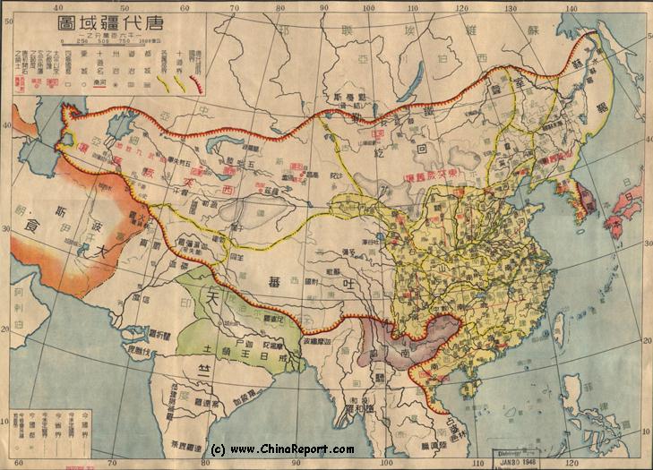
Schematic Map of the Tang Dynasty (618 AD - 907 AD) Empire at its High Point during the 7Th Century AD. This Map, produced in 1948 AD clearly shows Tibet as a separate Territory, which is in a Tributary Relation to the Tang Empire (after 641 AD). This relation had been reversed in 763 AD & afterwards only briefly reoccurred.
the largest inland fresh water lake and thus to the nomadic peoples of enormous importance. With the sacred and strategic Kokonor in enemy hands, in the long run victory for the Tibetans was far from assured. The Tibetan King Gampo (Qizonglongzan in Tang Dynasty Records), hearing of the favored treatment for cooperating Tang subjects and how they were able to marry Tang Princesses, decided to opt for the easy way out. Instead of doing battle the King would spare his subjects and attempt to appease and outwit the Chinese. In an offer of virtual surrender and subtle diplomacy the King requested to marry a Tang princess.
Earlier in 624 AD, however Gampo had subdued the Domi people who had been subjected by to the Tang Throne just beforehand. Furthermore, before making his smooth diplomatic offer, Gampo had moved 200.000 Men in position to threaten the Tang Dynasty City of Songzhou. These acts were not easily dismissed by such a strong Military Man as Emperor Taizong and not allowing Gampo to threaten him this openly, the Tibetan King was initially turned down by the Tang Emperor.
Oddly, after the Tibetan Army had carried out its threats and attacked Songzhou but was repelled by the Tang, the Chinese Emperor went ahead and granted the 'wish to surrender'. But only after Gampo had (largely symbolically) groveled and utterly humiliated himself in apologies for the whole affair.
Songtsan Gampo, the clever Tibetan King would go on to conquer and unite more of Tibet and a part of current day Sichuan Province under
Tibet
This page was last updated on: July 10, 2017
My Great Web page
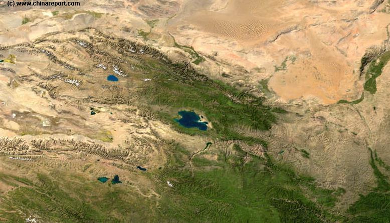
North-east Tibet & Gansu Province Map 3 - Satellite Map
A Satellite Image based Map of Gansu Province entire and neighboring provinces clearly depicting the natural terrain features that shaped the Province of Gansu in History. Browse around the Image to the outlines of the Gobi & Tengger Deserts, view the Qinghai Plateaux extending from the West providing borders with Gansu Province and Sichuan Province. Central Gansu Province around the Capital of Lanzhou is formed by the Loess Plateaux and the flow valley of the Yellow River (Huang He). Otherwise distinct areas are the Throat of China, Hexi Corridor extending to the North-West and the Ningxia Yellow River Valley, a separate autonomous region and green patch in the North-East.
auspices of the Tang Emperor (The area's conquered today still have Tibetan speaking "Minorities" who are actually the descendants of the original inhabitants. Until 1950 these area's had a majority Tibetan population known as the Khampa's). When King Tsonam finally died in 649 AD, he was a valued Tang Asset in the Region and thus received a condolence letter from the Tang Emperor himself (650 AD).
KOKO NOR
X
"In 710 AD responding to the request of King Chide Zugdan of Tibet, the Tang Emperor Zongzong sent Princess Jin Cheng to Tibet to marry him. Afterwards they often sent envoys to each other."
Bhurmese Territory and the current day Province of Yunnan the home of annoying and fiercely fighting Tribal Peoples and a rugged high mountainous area had not been conquered. (These latter regions along the Chinese border would retain much of their local independence and a reputation for "banditry" (armed local militia) until at least the 1980's and are still notorious regions of smuggling, arms dealing and other woes even today).
Himalaya
Mts.
On the flat grassy plains around Kokonor (Today dubbed Qinghai Lake) not far from the Chinese base area's the Tibetans were no match for the ammased Tang Military which far outnumbered their nomadic few. Making use of their highly powerful crossbow the Tang Armies seemed to prevail.