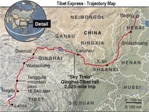
Currently the most important railroad in Qinghai Province is the now internationally famous Tibet Express, in China known as the Xizang or Qinzang Railway and/or more poetically as the 'Heavenly Road'. This railway connects the Capital of China,Beijing,withLhasa, CapitalofTibet(AR).
The construction of the Tibet-Qinghai Railway originally started in 1959 AD, coinciding with the final absorbtion of the entire Tibetan Region into the Peoples Republic of China. However, due to the economic difficulties suffered in China (P.R.C.) during the 1960's work was soon halted. Only investigations and planning were done for 22 years, until in 1985 work was officially restarted on this strategic railway.
Intotaltheentirerailroadmeasures1956 kilometers (1215 miles),alargeandratherwildsection of which lies within Qinghai Province.Infact,therailroadconnectsthroughLanzhoutoXiningandfromtherewestwardtoDaQaidamfromwhereitdescendstoGolmudandfurtheracrosstheTanggulaMountainsanddownintoTibetAutonomousRegion.
The railroad between Xining in East Qinghai and the Golmud in West Qinghai was the first section that was added to the existing railroad network in China. Theconstructionworkwasoriginallystartedin1959ADbythe'RailroadArmy',essentiallyanengineeringcorpsoftheChinesePeople'sLiberationArmy(thearmydirectlyundercommandoftheCommunistParty)withthemainstrategicaimofunlockingTibetforRailwaytransportandenablingChineseTroopstobetransportedinto this regioninamuchmoreefficientway.Thesecondarymotivesbehinditsconstructionwerenodoubtofevenlargerstrategicscope,asthedefenseofthefarwesternborderswithIndia(beyond Tibet) wouldalsobestrengthened.AttheTime, theonly otherrailroadtoChina'sfarwesternregionswasstillunderconstructionandledviaLanzhouinGansuProvince,northaroundtheTibetanPlateauxandthroughtheHexiCorridortobeconnectedtoUrumqi. The Urumqi Line only was completed by 1963 AD. NorailroadsintheWest,combinedwiththelackofroadsmeantdifficultyofmovementforChineseArmiesinthefarwesternregions. InmilitarytermstheWestwasopenandweaklydefended.
Inotherwords:alreadyintheverybeginningsofThePeoplesRepublicofChinatheRailroadtoLhasawasofvitalimportancetotheNationalGovernment, as was Tibet itself.
Until some twenty years ago road connections in Qinghai were nothing like they are today. Roads were sparse, narrow and often cut or threatened by rockfalls, flash floodings and winter snows. Today roads in Qinghai are still sparse. The traditional main route into Qinghai Province leads through Lanzhou, the Capital of neighboring Gansu Province which lies at a relatively short distance. This is the Highway G109 or Lanzhou-Xining Expressway. Lanxi for short.
TherearecurrentlythreeairportsavailableinQinghaiProvince. These are in order of importance; Xining Cities' Caojiabu National Airport, Golmud National Airport, and a third in Yushu County (Gyêgu) named Batang Airport.A(non-military)air-connectiontoLhasa(fromChengdu)hasbeenavailableatleastsince1965AD.Theair-connectionbetweenGolmudandLhasahasbeenavailableatleastsince1975AD.
The second route into Qinghai Province leads from Chengdu City to the West, then North-West into North-Western Sichuan Province. This route keeps south of the Bayan Har Mountains with create a natural border with Sichuan and passes through the Towns of Garze and Serxu (both with large Tibetan Minorities) across the Provincial Border into the South Qinghai Basin. The first leg of the route past Garze is made up National Road G317, but after reaching Manigange Village (Xiang) one turns onto Provincial Road S217, a narrow winding path. Once within Qinghai Province, the S217 conects to road S307, then not much later to National Highway G214 connecting to Yushu, the main population center in this area, and its Airport.
The third route was the last established. This is the G109 National Road which passes from Lhasa in Tibet (Autonomous Region) northward to Nagqu, and from there to Amdo and through the Tangula Mountains into Qinghai. After crossing the Tangula Mountain pass the road winds it way between the mountains and past several villages before reaching Golmud. The Road connection to travel Eastward to Xining lies further North at Da Qaidam, near the border with Gansu Province.
As noted historically the first and foremost Route into Qinghai Province is through the City of Lanzhou in Gansu Province which has both a strategic
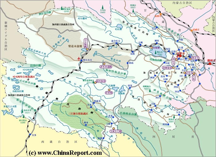
A Full Google Earth Supported Map of Qinghai
Roads & Highways in Qinghai Province :
Airports andAirfieldsin Qinghai Province :
included large scale land-reforms and other radical policies throughout the 1950's, these ground the Chinese Economy to a halt for many years to come, forcing the abandonment of construction of the remote Tibet Railway. It was at the same time that the Central Government started suppressing expressions of traditional beliefs and culture, replacing them with Communist Discussion sessions and other indoctrination meetings. The latter policies among things resulted in additional frictions with the Tibetans (and other Minorities), who were increasingly worried about joining in The Peoples Republic of China. Suddenly, guarantees of equality with the Han and promises of Ethnic Autonomous Rule in their own Land with their own customs clearly were contradicted by the actions and policies of the Communist Party. The Chinese had already started on unequal footing by launching a Military Invasion of East-Tibet (Amdo) in 1950 AD, defeating the small Tibetan Army, claiming as much Territory as they could by Military means and forcing the until then Independent National Government of the Tibetans (under spiritual leadership of the Dalai Lama) into 'friendly' negotations with 'Beijing'. In essence, lacking a railroad for
and historical connection with the Capital of Qinghai, Xining.
Qinghai Province is the largest Province (Not Territory) of China (P.R.C.), measuring some 1200 kilometers from West to East and around 800 kilometers from North to South. Average altitude inside the Province is around 3000 meters, however 54% of the Province lies at altitudes between 4000 and 5000 meters. Mountains within Qinghai Province can reach over 6500 meters. Altitude is always a consideration when traveling through Qinghai, easily changing weather is another one.
MosttransportinQinghai Province,especiallyofTouristantravelerspassthroughtheCityofXining,fromwhereconnectionsradiateacrosstheprovince.XininghasamodernairportandisanimportantStationon'TibetExpress'fromBeijingtoLhasa.Althoughseverelyupgradedandextendedsincethe1990'stheroadandrailnetworkinQinghaistilldoesnotcovertheentireruggedandmountainousProvince.Apartfromthisallmodesoftransportareinfluencedbytheharshclimateofthe(North-EasternTibetanPlateaux(See: Qinghai Province Index - Climate). Winters in Qinghai are Cold, harsh and long, therefor during many months of the year passage to Golmud and other even more remote locations is inter-mittently blocked by snowfall and icing.
The Tibet Express railway from Xining, through Golmud to Lhasa is a priority railway line and often retains schedule. The Tanggula Pass however is the highest railroad passage found in the World and is often blocked in winter.
Check out the sections on Rail-, Road- and Air-travel below for travel details to find your way to each region and popular destination.
massive military transports into Tibet, the Chinese Side had to rely on a strategy of intimidation and forced negotiations while looking for better options.
While 'The Great Leap Forward' launched in 1958 AD only served to bring chaos to the economy, work on the the Tibet Railroad remained at a stand-still and Tibet remained in relative seclusion along the fringes of the 'New China' (Xinhua), an ambitious and nationalistic Communist Chinese Empire.
The thought was however never lost, and preparations continued albeit only on paper. Thus, as soon as Government Finances allowed for it, the important strategic project was restarted at once.
The engineering corps of the Peoples Liberation Army reappeared in East Tibet (Qinghai) in 1974 AD some 2 years before Mao Zedong's death. At that time around a massive 100.000 men were sent to have another try at this vital strategic project. For years they struggled with both climate, altitude, mountainous barriers, earthquakes and the snow and sand-storms the region is notorious for. The Qaidam Basin in West Qinghai is known for its high-altitude deserts which means lake waters are salty and so water supplies for the army mainly had to be trucked in at enormous effort in order to keep the men in action.
Several Times work on tunnel sections had to be halted. Disaster struck on April 5 of 1975 when a section of the Guanjiao tunnel collapsed burying and killing many of the soldiers on site. Although officially no lives were lost and all inside the Tunnel rescued, later during the construction of this 4 kilometer tunnel 25 soldiers lost their life in building the tunnel. Construction of Guanjiao Tunnel lasted 4 years and it came available in 1982 AD.
The 815 kilometer (506 miles) long Xining to Golmud line was finally completed by 1984 AD. In the process some 300+ Chinese lives were lost.
Arailway-linetoLhasawouldhavebeen completed a long time ago, regardless the obstacles that would have to be overcome or the dangers involved or lives to be sacrificed, had it not been
for 3 years of grave natural disasters that struck China (P.R.C.) in the 1950's leading to a Great Famine in the year 1956 AD. Together with the disastrous policies of the Central Government in Beijing which
The second leg of the journey, the railroad to Lhasa could not be completed at that time due to the technical challenges of operating a railroad over 5000 meter high mountains and the issue of the permanently frosen underground, the 'permafrost', which if melted might undermine whole sections of the railroad.
After further preperations and environmental evalutions, in June of 2001 AD construction was started on this most challenging section, connecting from Golmud across the 6000+ meter high Tanggula Mountains into Tibet Autonomous Region and the end station at Lhasa. Conditions in this region are difficult most times of the year. In addition the Tanggula Pass included in the Xining to Lhasa railway line reaches a staggering 5,072 meters (16,640 feet) above sea-level making it a formidable obstacle for any combustion engine. The Tanggula railway station (located at 5,068 meters) is the highest station in the world and already an extreme tourist destination.
Regardless, technical obstacles were surmounted and the 1142 kilometer (709 mile) section between Golmud and Lhasa was inaugurated on 1 July 2006 by president Hu Jintao to much national applause. Eversince a journey on the railway line has become one of the Great Railroad Experiences of the world. Apart from the highest railroad mountain passing in the world at Tanggula Pass, the railroad includes spectacular tunnels such as the 1,338 meter long Fenghuoshan tunnel which today is counted as is the highest rail tunnel in the world at 4,905 meters above sea level. The spectacular Guanjiao tunnel on the railway line from Xining to Golmud with its 4,010 meter length is the longest railway tunnel in Qinghai Province (and China) and the railroad section from Golmud down to Lhasa includes another lenghty tunnel, the
According to the Chinese Railways more than 960 kilometers, or over 80% of the Golmud-Lhasa section, lies at an altitude 4,000 meters or more. There are 675 bridges on the Qingzang Railroad in Qinghai Province and Tibet Autonomous Region, totalling together 159.88 kilometers of railway.
Another notable fact is that some 550 kilometers of the railway are laid on permafrost, which means supposedly permanently frosen but otherwise boggy grounds. So far this has not caused major disruptions of the Line.
As noted historically the first and foremost Route into Qinghai Province is through the City of Lanzhou in Gansu Province which has both a strategic and historical connection with the Capital of Qinghai, Xining.
The Development of Tibet will not end with the extension of the railroad from Xining to Lhasa in Tibet. According to earlier outlined strategic Military demands further extensions of the railroad to the Indian and Nepali border are required for a proper in-depth defense of the Western Regions of The Peoples Republic of China, mainly against any Indian threat or cross-border terrorism. Naturally, the railway is also helping to solidify Chinese control and influence inside Tibet, and is intended to develop Chinese contacts with Nepal and Bhutan which will likely fall under increasing pressure from their large and growingly powerful neighbor China. Airports, allowing for an even greater degree of mobility and shorter response times are also under construction across Tibet.
As was to be expected, in a meeting between Chinese and Nepalese officials on 25 April 2008, the Chinese delegation announced that country's intention to extend the Qingzang railway from Lhasa to Zhangmu (Nepali: Khasa) on the Nepalese border. Nepal had requested that the railway be extended to enable trade and tourism between the two nations. Construction of the extension is planned to be completed by 2013 AD.
The main airport in Qinghai Province is Xining Caojiabu National Airport. Located some 29 kilometers due east of the city of Xining this National airport has only been operational since May 25th 1999. Before that time there was no airfield in Tibet, other than a provisional one at Lhasa. The only way in until 1984 was by road. Airports are now greatly faciliting the transport of persons and supplies across Tibet, unlocking previously remote corners.
Only recently, on August 1 of 2009 AD, a third airfield was opened at
Map of Qinghai Province and wider Regions indicating among things the Airports currently available in the Region.
Yushu, giving direct access by air to Yushu (Gyêgu), the Capital City of Yushu Tibetan Autonomous Prefecture (玉树藏族自治州) which lies at 814 kilometers distance.
Yushu Airport has a 3.800 meter runway and is located 18 kilometers due south of Yushu at Batang Xiang (village) and
In hindsight, the opening of the airport at Yushu came just in Time to help in flying in rescue workers and relief equipment and materials in the aftermath of the heavy earthquake that struck the Yushu (Jyekundo) Region on April 14Th of 2010 AD. The airport remained operational although roads leading to it were temporary blocked and sections of them destroyed. Except the interruption of wired communication and exterior power supply no problems were experienced in the operations of the airfield. The radio communications gear and self emergency power supply helped the airport through initial hours after the main jolt. The airport is currently the focal point of logistics in the ongoing effort to overcome the effects of the earthquake for Yushu's destitude population.
lies at 3950 meters above sea-level making it currently the fourth highest civil airport in China, following Tibet's Ngari Airport (to be opened in July of 2010 AD) at Ngari Tibetan Autonomous Prefecture in South-West Tibet Autonomous Region, Bangda Airport at Chamdo and Lhasa Airport. The opening of the airport has drastically cut the traveling time between the provincial Capital Xining and Gyegu Township. What was until recently a grueling overland journey of 15 to 19 hours frought with altitude sickness has been cut down to a comfortable ride that takes a mere 70 minutes. For now only regular flights between Yushu and Xi'an will fly via Xining on Tuesdays and Saturdays. Later a direct connection with Dartsedo / Kangding, the airport of Garze Tibetan Autonomous Prefecture in neighboring SichuanProvince is expected. Possibly this air route is already operational.
On 17 August 2008 AD, a railway spokesman confirmed plans to add six more rail lines to the Qinghai-Tibet railway. The first of a total of six new tracks to be included are one from Lhasa to Nyingchi, one from Lhasa to Xigaze, both in the Tibet Autonomous Region. Three tracks will originate from Golmud in Qinghai Province and run to Chengdu in Sichuan province, Dunhuang in Gansu Province, and Kuerle (Korla) in Xinjiang Uygur Autonomous Region. The sixth will link Xining, capital of Qinghai, northward to with Zhangye in the Hexi Corridor of Gansu Province. The six lines are expected to be completed and put into operation before 2020.
Possible stations further stations to be included into following expansions are Khasa in Nepal and Yatung.
Travel from Beijing in North-East China to Lhasa in Tibet in 24 Hours !