County of Gonghe - No -- sq Kilometers (-- sq miles)
Population: The Total Urban Population of Gonghe & County is around - no information available, with an additional - no information available - living in the rural area's.
Under its original Tibetan name Gonghe Town and surrounding county are known as Kungho or Chabcha County. The seat of Gonghe County is in the Town of Qabqa (Chinese: 恰卜恰 Qiàbŭqià).
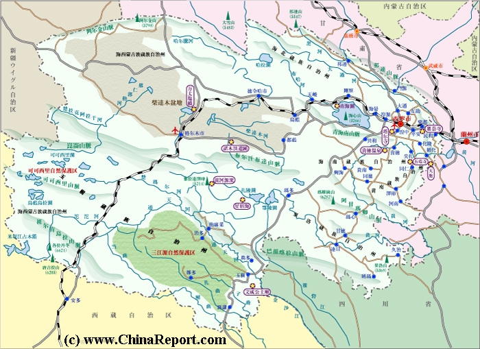
As can be seen on the below schematic map of Qinghai Province, Gonghe (Qabqa) is situated near the
The China Report
The Gonghe Report is part of the overall website www.ChinaReport.com & www.drben.net
Learn about what is new on this Site from below window.
ChinaReport.comat
A Full listing of GongheandCounty Landmarks, Monuments, Hotspots and other sites of importance in alphabetical order. Search through the list to find your Full Report and Photo-Virtual Tour of each monument or landmark within the City, or Region of Gonghe in HainanPrefecture, Qinghai Province of China (PRC).
Public Transport in Gonghe
The Main and only Railway Station of Gonghe is ...
Gonghe
Gonghe has a Railroad Station. For air-connections the Town relies on nearby Xining National Airport.
Gonghe is a small originally Tibetan Town in what today is known as the Hainan Tibetan Autonomous Prefecture of Qinghai Province.
Gonghe County was a part of the independent territory of Tibet until 1949 AD at least. For more information on the history of the locality, please refer to:
History of Tibet, or our section on the history of north-east Tibet (Amdo) in "History of Qinghai Province" which exclusively and falsely deals with the history of the region from a Chinese and International viewpoint in which the Province is part of the Peoples Republic of China (P.R.C.).
No information available at this Time.
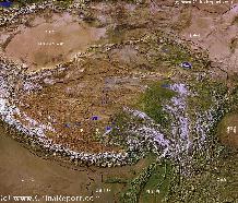
Tibet-TibetanPlateaux-SatelliteImageOverview 1A
A SatelliteImage overview Map of the entireTibetanPlateauxincluding parts of bordering regions of Xinjiang-UyghurAR, Gansu Province, NingxiaHuiAR, Inner-MongoliaAR,Sichuan Province,andYunnan Province. Surrounding nations and Territories are: Myanmar (Burma), Bhutan, Sikkim, Nepal, Bangladesh, India, Kashmir and Pakistan.
This Map clearly defines Provinces and Regions, main mountain ranges, main rivers & lakes of the region, locations of main cities and landmarks.
No information available at this Time.
Hotels & Hostels in Gonghe & County
No information available at this Time.
There is currently no information available on climate and weather in Gonghe specifically. Please refer to 'Climate and Weather in Qinghai Province' for the best available data.
Find DrBen and ChinaReport on Facebook with the latest from www.drben.net.
fast receeding southern edge of the Koko Nor, dubbed by the Chinese as Lake Qinghai, the largest fresh water lake on the Tibetan Plateaux and in the previous millenium a location of abundant green grass, pastureland and the encampments of nomadic herders eager to feed their horses and animals on the grass and the fresh water. The town is situated on the Qinghai Plateaux along the northern rim of the Qinghai Nan Shan (Qinghai South Mountains) and situated some ways north the valley of the upper flow of the Yellow River (Huang He) in this region.
Today's Qabqa is the town of Gonghe, a Han
Chinese dominated rural town at but an hours drive along a spacious highway from the Provincial Capital of Xining, its military garrison and fully modern airport.
Officially Gonghe is the seat of the Hainan Tibetan Autonomous Prefecture, however today it is firm under control of the Provincial Government and the P.R.C. The town has hardly a wild west feling to it, can hardly be regarded as autonomous or Tibetan as it is now populated with Han Chinese migrants.