Generally the period from March to October is the best time to pay a visit.
Lhasa is notorious for having large temperature differences during the day, leading to special clothing requirements.
The High altitude in Tibet creates a need for acclimatization. Just to be sure, take it easy the very first few days especially if you flew in from a location at sea level.
The high altitude circumstances also make for a high frequency of sunshiny days, which is great for sightseeing but easily leads to over exposure. Make sure to bring your sunglasses, suntan oil, or perhaps a hat for enduring the sun. At the same time it is very important to make sure one drinks enough, easing the potential for headaches and other symptoms of (high) altitude sickness.
Ethnic Minorities in Lhasa & Prefecture
Lhasa & City Today :
History of Lhasa :
Local Geography of Lhasa :
Lhasa Basic Knowledge :
This page was last updated on: July 25, 2015
The Lhasa Report
Introduction to Lhasa ( ལྷ་ས་གྲོང་ཁྱེར། ; 拉萨)
Lhasa Landmarks & Monuments
Lhasa City & Area Maps
Location : (....)
Elevation : 3650 Meters (11.975 feet).
Surface Area of Lhasa Prefecture: 30,000 square kilometers (11,583 square miles)
Urban - No information available.
Population: The Total population of Lhasa Prefecture is registered as around 400 thousand.
The Urban Population of Lhasa City is around 180 thousand souls with an additional 280 thousand living in the rural area's of the City Prefecture. Not until less than 70 years ago an exclusively Tibetan city with but a few Foreign inhabitants, recently Lhasa has been a drastically changing city seeing an ongoing influx of Chinese migrants as well as on ongoing parade of Chinese (mainland) Tourists.
GENERAL INTRODUCTION TO LHASA:
Lhasa is the ancient Capital City of the Nation of Tibet and today serves still as the Capital of the so called Tibet Autonomous Region which makes up but a minor part of the former territory of the Tibetan Nation proper.
The City of Lhasa is situated in a very extra-central location upon the southernmost parts of the Tibetan Plateaux in the most fertile and hospitable regions that traditionally formed the southernmost regions of the the Nation of Tibet. Within the Nation of Tibet it lay between the U-Tsang Region in the north and the Tsan Region situated it to the south of the city, in the direction of the norder with the sister Nation and Kingdom of Bhutan.
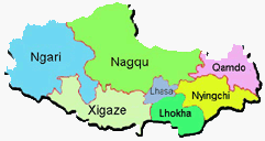
Within the much smaller Tibet Autonomous Region (T.A.R.) of today, it is situated almost centrally, within its own City Prefecture. The surrounding Prefectures of the Tibet Autonomous Region are: Nagqu to the North, Nyingchi to the East, Lokha Prefecture to the south-east and finally Xigaze (Gyantse) Prefecture to the south.
Only about half a century ago, or even a bit later, Lhasa was to be considered an ultra remote location. Not only did it lie well beyond the highest mountain range in thw world - the Himalayas - it was also the Capital of a most reclusive Nation which, at least up to year 1900 AD, had very little contact with the outside world. Not one road led to to the City and thus, travelers to and from had to make do with the well trodden mule paths leading over high passes and down the valleys, among things to the Indian Border at a distance of around 500 kilometers away. The few "roads" created by the nomadic trading caravans were the main paths leading southward to Nepal (Kathmandu), the Kingdom of Sikkim (now absorbed into India) and Thimpu the Capital of the neighboring Buddhist Kingdom of Bhutan. Other well traveled paths led westward all the way to Kashmir and north eastward from Lhasa via Yushu (Gyegu) to Xining (in Qinghai Province - formerly in Amdo Province of Tibet) at a distance of around 1100 kilometers away.
ChinaReport.comat
The Main Landmarks and scenic sights of the city of Lhasa are the Potala Palace, the Barkhor circular road, the Jokhang Temple and the Norbulingka "Summer Palace" with its large Garden Park.
The historic Drepung Monastery located at the foot of Mount Gephel is by now part of the suburbs of greater Lhasa and offers the opportunity for a visit to an original Tibetan Monastery of the Yellow Hat Sect. Although battered already during the initial Chinese invasion and take over in 1954, today the Monastery - as have the other religious sites within the Capital - has been renovated and turned into a hive of tourist activity.
Sera, the second of the Three Buddhist Universities of Tibet, which is situated due north of the old city center, offers another chance to venture about a Tibetan Monastery. Better take care to mind your manners at all time, and keep an eye out for fake monks who are members of the in-house security detail. At the Sera Monastery people love to come and witness the debating of the monks, an ancient art form essential in the traditional style of teaching of Buddhism in Tibet.
Excursions to Ganden Monastery, Namtso Lake and the "Heaven Lake (Yamdrok Yumtso Lake)" combined with a visit to Ramoche Temple take one away from the city proper although remaining safely within the allowed zone for Foreign Tourists.
A Full listing of Lhasa City and Prefecture Landmarks, Monuments, Hotspots and other sites of importance in alphabetical order. Search through the list to find your Full Report and Photo-Virtual Tour of each monument or landmark within the City, or Region of Lhasa in Tibet Autonomous Region of China (PRC).
Public Transport in Lhasa
The Main and only Railway Station of Lhasa is - With the operation of Tibet Railway from July 1st, 2006, more and more visitors have swarmed into the land via train.
Travel to Lhasa by Airplane, Train or overland by Road. Lhasa has a Railroad Station as well as a National Airport.
The Lhasa Train Station, the hub of the Tibet Railway is situated on the south bank of the Lhasa River on the opposite bank versus the Old City with its monuments.
The Lhasa Gongar Airport is situated at a further distance, down the road and in the adjacent valley of the Tsangpo or Brahmaputra River.
LHASA GONGGAR INTERNATIONAL AIRPORT:
Lhasa has one airport, the Gonggar International Airport situated adjacent the town of Gongar which lies at a distance of 98 kilometers (miles) away from the city of Lhasa proper. The distance can be bridged in the time of around one hour traveling by car or taxi. As a convenient and cheap alternative, regular shuttle buses travel to and from the airport.
The history of the city of Lhasa is taken to have started in the year 637 AD when Songtsän Gampo the 33rd King in his Dynasty and the founder of the Tibetan Empire known as Bod (Chinese:吐蕃) or also Tǔbō or Tǔfán had gained enough power moving the Capital of his Tibet to the location of the current city of Lhasa.
It became the center of Tibetan Government, politics, economy and culture.
- Lhasa Beijing Middle School; situated in the south of the city on Tianzu Island in the Lhasa River, due north west of the Lhasa Conference Center.
- Lhasa Lucky Baby Bilingual Kindergarten; located in the south of the city, on the west side of Tianzu island in the Lhasa River.
INDUSTRY AND COMMERCE:
- Lhasa Conference Center; situated in the south of the city on Tianzu Island in the Lhasa River.
General Commerce:
Tibet Chuanjiayi Decoration Ltd. Co. ; situated on the west tip of Tianzhu Island in the south of the city.
Trading Companies:
Tibet Keshida Trading Co. Ltd; on the west point of Tianzu Island in the Lhasa River.
Tourism Industry:
- Tibet Nyingchi Xiangbala Tourism Limited Company; located in the south of the city of Tianzu Island in
the Lhasa River.
According to various International Organizations of Journalists Press Freedom is non-existent in Lhasa and the remainder of the Tibet. In their words, the press situation in North Korea is better than in Tibet today.
Within the Peoples Republic of China the attitude towards traveling in Tibet is entirely different, mainly due to an ongoing information black-out on real Tibetan issues combined with abundant advertizements depicting Tibet as wonderful tourist destination which can combine clean air, fabulous sights and cultural wonders. Among things, the city has long been known and officially nominated as one of the 24 historical and cultural cities of China, a must visit destinations for the growing number of middle class citizens and elite travelers.
INTERNATIONAL CONSULATES:
Consulate General of the Kingdom of Nepal;
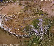
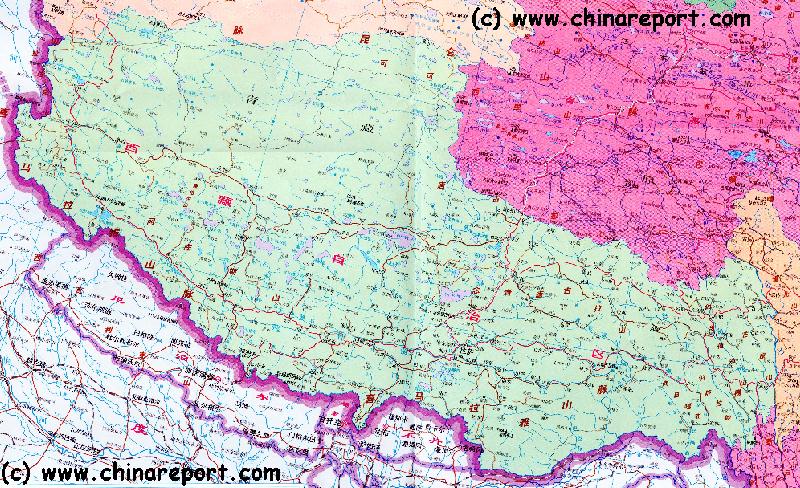
Tibet-TibetanPlateaux -SatelliteImageOverview 1A
A SatelliteImage overview Map of the entireTibetanPlateaux including parts of bordering regions of Xinjiang-UyghurAR, Gansu Province, NingxiaHuiAR, Inner-MongoliaAR,Sichuan Province,andYunnan Province. Surrounding nations and Territories are: Myanmar (Burma), Bhutan, Sikkim, Nepal, Bangladesh, India, Kashmir and Pakistan.
This Map clearly defines Provinces and Regions, main mountain ranges, main rivers & lakes of the region, locations of main cities and landmarks.
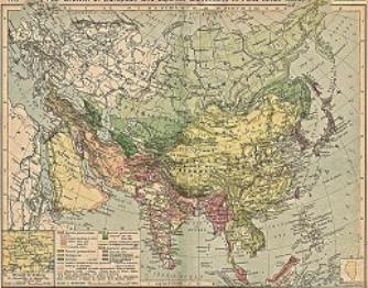
China Report - Colonialism - Growth of Colonies & Japan after 1801 AD
A Map drawing of the Eurasian continent , parts of North-East Africa and the Middle East in the 19Th Century between 1801 AD and 1900 AD. Focal points are the expansion of western colonial posessions of Portugal, Britain and France, as well as Russia moving from West to East. Labeled seperately is the later Rise of the Empire of Japan in the East.
Included in this Map are the main cities across the continent with their brief histories and events during the 19Th Century. Marked in Colors for clarity are the various colonial and imperialist Nations. As relating to China; special attention is payed to so called Treaty Ports. The First Treaty Ports were forced open by Britain in the year 1841 AD, but counted over 80 in total by the end of the 19Th Century. The most important Treaty Ports in China are marked and described with a short history where the map allows.
The city of Lhasa is limited by mountains to the west, north and east. To the south of the city flows the Lhasa or Kyichu River. Further south of the city seperated by a bend of the Lhasa River valley and high mountains flows the largest river in the south of Tibet, the Yarlung Tsangpo River. Beyond the Tibetan cultural area's the river is known as the Brahmaputra.
RIVERS AND LAKES IN LHASA AND PREFECTURE:
The main river in Lhasa is the Kyichu also known as the Lhasa river. The city can be found on its northern bank and the river flows in the direction west to east and can be found due south of the old city center.
The Lhasa river ultimately emties into the Yarlung Tsangpo River at some distance to the south of the city of Lhasa. The airport is not situated in the valley of the Lhasa River but in the much wider valley of the Yarlung Tsangpo between Jiazhulinzhen and Gonggar town.
This page was last updated on: July 25, 2015
My Great Web page
Although some popular Chinese published travel website with information on the Lhasa claim that as many as 87% of all inhabitants of Lhasa are of ethnic Tibetan descent, these numbers are unfortunately highly inflated and untrue.
Lhasa City Hotels - Hotels in Lhasa
A wide number of Chinese owned and run Hotels is available in the City of Lhasa. Most of the best hotels are however Chinese owned and run, the revenue coming to the benifit of Chinese Companies while paxes are payed to the State of the Peoples Republic of China. In addition, these Hotels frequently hire Chinese staff whereas employing few local Tibetans leading to criticism.
Due to the the different levels of economic well being between the Han Chinese and Tibetan population, Tibetans have been economically marginalized over decades and so today Tibetan owned and run Hotels are scarce. They do however exist.
As many Hotels are Chinese owned and run establishments the revenue of which does not come to the benefit of Tibetans, companies who do not tend to employ many Tibetan Staff, we do recommend you take time to sort out your attitudes and perhaps take the opportunity to stay at a genuine Tibetan owned and run Hotel establishment.
Very recently, several new Hotels have come under construction including controversially at least one Hotel owned by the International Hotel Chain known as "Intercontinental Hotels and Resorts". As a result Intercontinental has already been faced with personal ban's, calls for Boycott via various social media channels and demonstrations at various Intercontinental Hotel locations world wide.
International investments in the Tibetan Tourism Industry are highly controversial. Most International Hotel Chains have reservations about the ethics of entering into business within Tibet, especially in Tibet Autonomous Region and the symbolic center of the Tibetan Soul, the city of Lhasa. Rightly, they are also afraid of negative sentiments arising from any decision to build and do business in Tibet today. It is not therefor expected many International Hotel Companies will follow the example now set by Intercontinental Hotels and Resorts.
BRIEF LISTING OF AVAILABLE HOTELS IN LHASA:
Click through to find an complete listing of Hotels in Lhasa.
Direct Booking: Check the various Booking Options for Lhasa for available rooms.
Today, due to the necessities created by the Chinese Invasion of 1959 AD and the repeatedly arising
mass resistance among the native Tibetan population there after, Lhasa is a well connected city which has several roads leading to it. In the eastern direction one can travel via Nyingchi Town directly through to either Chengdu in Sichuan Province and the mega city of Chongqing or turn southward to reach Kunming - the Capital of Yunnan Province via the Tibetan Town of Deqen, the popular tourist destination cities of Lijiang and Dali. Yet another highway leads northward to Nagqu County Town where it splits into the road leading to Golmud and another copying the traditional historic route via Gyegu (Yushu) to the city of Silung (Xining), now the Capital of Qinghai Province (East Tibet). A last highway leads westward to Ngari County Town from where it extends for over a 1000 kilometers traveling over to Ngari (Gar) to Rutog in Rutog County in the Ngari Prefecture near the
disputed mountainous border with the restive regions of Jammu and Kashmir, split between the Peoples Republic of China, India and Pakistan.
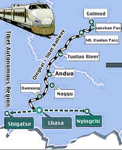
Apart from to the various highways leading to Lhasa, in the year 2006 the so called "Tibet Railway" was opened, the highest railway in the world, connecting Beijing - the Capital of neighboring China directly with the Chinese occupied Capital of Tibet. The route leads via Lanzhou in Gansu Province to Xining and from there around the barren Da Tzaidam high plain and salt basin down to Golmud (Geermu). After Golmud the train passes the highest pass on its route, the Tangula Dangla Pass on its way to Nagqu and finally Lhasa. Only recently built, various new train lines connect to Shigatse and other destinations.
In addition there is the Lhasa International Airport, a dual use civilian-military airfield.
(For more information on the Tibet Railway, please refer to: "Public Transporation in Lhasa (and Tibet)").
Historically, the city of Lhasa had a magical allure for tourists almost anywhere on the planet, as it is home to the magical, mystical and magnificent Potala Palace, the home and seat of his Holiness the Dalai Lama, and a Palace in the sky. Tibet then, hidden behind its wall of high mountains was a forbidden realm until well into the 1940's - off limits to (but a few) Foreign visitors and today it still is a mythical realm of exotic art, Buddhism, abundant monasteries and colorful clothing and customs in the imagination of the average traveler. There are just no words for the unrivaled attraction that the Nation of Tibet and its Capital traditionally have on international travelers, dreamers, explorers, mountaineers and others alike.
That said, the fabulous history and romance of the Nation of Tibet have long been overshadowed by its larger, much more populous and clearly more aggressive neighbor, the Nation and people of China inhabiting the various river valleys to the east of Tibet.
Having first been invaded in 1954 AD and with the Dalai Lama fleeing the Capital in the year 1959 AD never since having been allowed to return, an utterly dark chapter in the history of the Nation has overshadowed the joy and bliss imagined by many a reader, writer and of course would be traveler.
Countless atrocities have been commited since the year of the flight of the Dalai Lama and an ensuing Nationwide uprising against Chinese Domination and much culture and many cultural items destroyed. The people have been bullied, humiliated, mistreated, intimated, silenced and more, whereas the city of Lhasa has been enlarged, bombed, repaired - overal changing unimaginably compared to its state but half a century ago. Although the glorious golden lined facade of the Potala and the city do not reveal much of it today, underneath, the scars both physical and psychological must be huge. On the streets however, no word of this can or will be uttered.
Seeing an unimaginable destruction throughout the long years of the rule of the Chinese Communist Party, before, during and well after the much bemoaned "Cultural Revolution Era" (1966 AD - 1976 AD), the city has seen an influx of Han Chinese migrants of the last 20 years. Most recently, the final and most sacred sections of the inner city; the old city of Lhasa which is listed as a UNESCO World Cultural Heritage site (along with Potala Palace, Jokhang Temple and the Norbulingka) have been "renovated", ostensably in order to enlarge the pleasure of- and service to visiting flocks of (mainly Chinese) tourists, but certainly also in order to allow security forces better access and less resistance in case of yet another popular Tibetan uprising.
HISTORY OF LHASA AIRPORT:
The Gonggar Airport is not Tibet's very first airport. The first Airport to be opened in Lhasa was the Damxung Airport, a limited and primitive airfield that came available in 1956 AD some two years after the overland invasion by the Chinese Peoples Liberation Army. At the time the airport almost exclusively served the Chinese Military, functioning as an additional quick transportation route for crucial equipment, goods and personel. It was only in the year 1965 AD, many years after the massive anti-Chinese Tibetan Uprising in the year 1959, that a passenger terminal was constructed and opened, allowing for the first regular passenger flights to commence. Ever since the year 1965 regular passenger flights connect that once reclusive and ultra-remote city with the city of Chengdu, Capital of China's most populous Province of Sichuan. From there, direct flights connected through to Beijing.
The opening of the air route mainly helped to keep channels open with the remote and now "peacefully liberated" Nation of Tibet, a gargantuan occupied zone at extremely high altitude, allowing for the transport of fresh officers and apparatchiks and their communications back to the National Capital Beijing from where much of the political direction of the " modernization of Tibet" came from. There was no tourism industry to speak of, and as one can find out in the Section on the History of Tibet, throughout long periods in the far and recent parts, travel to Tibet was highly discouraged by the Chinese Government. Even today, many restrictions on travel to Lhasa and even more so the rest of Tibet are in place.
GONGGAR AIRPORT TODAY:
The airport itself is found a a considerable distance away from the city of Lhasa, situated not in the Lhasa river valley but in the much larger and more spacious valley of the Yarlung Tsangpo river to the south of Lhasa on the other side of a high ridge of Mountains. The airport lies between the small town of Jiazhulin (Zhen) and Gonggar along the S101 road. Upgraded and renovated as recently as the year 2004, the facility has a passenger terminal measuring 25 thousand square meters, allowing for 12 planes to dock at a time.
Lhasa Gonggar Airport is a dual use civilian and military airfield. Please note that some parts of the airfield are off limits. Military airplanes and helicopters parked on the field may be regarded as sensitive. No photography is allowed in- or around the airport.
As a result largely of military needs behind the design of the airfield and the extremely high altitude of over 11 thousand feet, the Lhasa airport has a very heavy and long runway of 4 kilometers in length. Thus, it allows for the accomodation of a large variety of aircraft, including the largest modern jet aircraft and transport planes. With its 4 kilometers long runway, Lhasa airport today has the longest runway of any airfield in the Peoples Republic of China. However, this may change soon as other airfields are open or under construction on the Tibetan Plateaux.
Altogether, currently Lhasa mostly resembles a city under siege. Tibetans have become a minority in their own Capital. Han Chinese Security forces, armed and in uniform, are everywhere in the city on patrol with vehicles and on foot in small groups. Security camera's abound and a multitude of other intimidating security arrangements exist. Internet and phone connections are highly restricted and well monitored, as are the Hotels. Although Chinese Nationals are mostly welcome to visit and enjoy a tour of the Capital Lhasa and its various scenic sights, Foreign Nationals are clearly restricted in their travels to and about the city of Lhasa. For travel outside the city, foreign visitors are requited to gain additional permits and allowances, which are rarely if ever granted.
The most popular scenic sights in Lhasa are the Potala Palace, Barkhor - the sacred circular road leading around the old town center, the Holy Jokhang Temple and the Summer palace of the Dalai Lama, the Norbulingka and its gardens. Naturally, although originally not that large limited by local geography and thus compact in size, there is yet more to see in- and around the city of Lhasa. The Sera Monastery is the leading local Monastery, followed by Drepung. A number of minor less renowned Temples can be found in the city as well.
MILITARY FUNCTIONS AND BACKGROUNDS ON LHASA GONGGAR AIRPORT:
In recent years the entire Tibetan Plateaux has been under increasing military development. This does not refer to the ongoing crackdown against political unrest under the local population but to an increasing number of airfields, roads and military stations being built up across the Tibetan Plateaux. As Chinese Peoples Liberation Army forces have increased their strength and mobility they have moved increasingly towards the (disputed) border regions with neighboring India, and to a lesser extend Nepal, Bhutan and Pakistan. On July the 23rd of the 2013, China for the first time announced it was holding high altitude flying exercises for its military, the mouthpiece Xinhua newspaper displaying photos of helicopters parked on the Lhasa airfield. Throughout the year 2013 tension along the southern borders of the Tibet Autonomous Region have been on the rise. Take due precautions at the airfield, although most of the sensitive military activity takes place well out of sight in the southern fringes of the mighty Himalayan mountains.
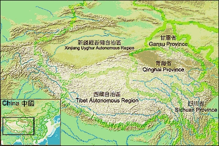
Min Map Overview of the Tibet AR showing the 6 Prefectures with Lhasa City at the center.
FLIGHTS CONNECTIONS AT LHASA GONGGAR INTERNATIONAL AIRPORT:
Currently, Lhasa airport is a busy airport which flight connections to a wide variety of cities in mainland China as well as regional destinations on the Tibetan Plateux.
Currently flights are made between Lhasa and Hong Kong and vice versa only seasonally.
Regional Flights:
At the moment regional flights are still extremely limited, although additional airfields are under construction on the Tibetan Plateaux. Only a decade ago there were no regional flights.
Currently the number of available Regional Destinations in Tibet Autonomous Region are: Chamdo in Chamdo Prefecture, Ngari (also: Gar or Shiquanhe) in Ngari Prefecture, Nyingchi of Nyingchi Prefecture and Diqing (Dêqên) in Dêqên Tibetan Autonomous Prefecture (formerly a part of Tibet proper now absorbed into the adjacent Yunnan Province of the Peoples Republic of China.
International Flights: Although the Lhasa Gonggar airport proudly names itself International, the choice of International connections is rather limited at this time due to various political differences with neighboring nations and restrictions placed upon travel by the Government of the Peoples Republic of China. As a result, the only international connection is to Kathmandu, the Capital of the small neighboring Kingdom of Nepal.
Direct View Video:
"Ngari Nagri:
Manasarovar to Everest".
Available from Amazon.com
Direct View Video:
"Au bout du chemin, Lhassa (At the end of the road, Lhasa)".