This page was last updated on: May 1, 2017
The below Satellite Image clearly depicts the Tibetan Plateaux in Asia, a region also known as the 'Roof of the World'. Super-imposed are the names of neighboring Provinces, Regions and area's of China as well as bordering Nations.
In the Peoples Republic of China these are; Xinjiang-Uyghur ARQinghai Province, Gansu Province, Ningxia Hui Autonomous Region, Sichuan Province and Yunnan Province. Bordering Nations and Regions are Myanmar (Burma), India, Bangladesh, Bhutan, Sikkim, Nepal, the disputed regions of Kashmir and Yammu, and finally Pakistan in the extreme West.
The China Report
Satellite Image Map of Tibetan Plateaux explained
Yushu
Mazhali
Pagnag
Wenquan
Nagqu
Turpan
Tianshui
Mandalay
Gar (Artok)
Gyangste
Shigatse
Tsangpo
Chong-qing
Patna
Benares
Gandak
River
Indus
Ngangla Co
Zhari Namco
Siling Co
Ho Sai Hu
Mts.
(Pendi)
Ulan Ul Hu
Yinma Goring
Ayakkum
Hu
Akikki Gol
Hetian
Cherchen
Aksu
Yarkant
Hotan
River
Bayan Har
Mountains
Aksu
Hei
River
Yarkent
Lop Nor
Mazong Mts.
Golmud
Himalaya Mts.
Xining
Zhongwei
Qinghai Hu
Yinchuan
Jiayuguan
YuMen Guan - Jade Gate Pass
Hexi
   Corridor
JiuQuan
Kathmandu
Jiuquan, Gansu Province
Wuwei
Zhangye
Wuwei, Gansu Province
Lanzhou
Sun Gate Pass- Fortress and Starting Point o/t Southern Route of the Silk Road
Dunhuang
ChinaReport.com at
To Main Menu of All Websites at DrBen.Net
Go to www.drben.net webring
Lanzhou, Capital of Gansu Province
Dunhuang, Gansu
Taklamakan Desert
Yinchuan, Capital of Ningxia AR.
Yarkent, Kashgar Prefecture, Xinjiang-Uyghur Autonomous Region
Ngoring
Hu
Gyaring
Hu
JiaYuGuan (Gansu Province)
Jade Gate Pass- First Pass in the West , End of Tang Dynasty Great Wall of China - Start North Route Silk o/t Road
Zhongwei + Great Wall of China - Ningxia/Gansu Border (Outer Layer)
TengGer Desert
Helan
Pass
Complete List of all Great Wall of China Locations & GPS coordinates - Click Here !!
Zhangye, Gansu Province
Xining, Capital of Qinghai Province
Site of Ancient Kharakoto, Capital of the Tangut Empire
Har
Hu
DawuKou - Jiucai Gou Great Wall of China - Ningxia/Inner Mongolia Border (Outer Layer)
Gobi Desert
Sichuan
Basin
Xinjiang-Uyghur AR
Ningxia
AR
Sichuan
Tibet Autonomous Region
Gansu
NEPAL
Kathmandu, Capital of Nepal
INDIA
BANGLADESH
MYANMAR
Yunnan
Qinghai
BHUTAN
SIKKIM
Pakistan
Kashmir
Yellow
River
Yellow
River
Altyn Tag
Kunlun
Mountains
Mountains
Qilian
Da Qaidam
Mountains
Mountains
Hima-
Laya
Golmud, Qinghai Province
Yellow
River
Tarim River
Keriya
River
Aksu, Aksu Prefecture, Xinjiang-Uyghur AR
Yellow
River
Cherchen River
Yellow
River
Yalong
River
Jinsha
River
Heng
Duan
Shan
Cherchen (Qiemo), Bayin-Gholin, Mongol Autonomous Prefecture, Xinjiang-Uyghur AR
Aksay
Chin
Mountains
Hetian, Hoton Prefecture, Xinjiang-Uyghur AR
Keriya (Mugala), Hotan Prefecture, Xinjiang-Uyghur AR
Keriya
Dabsan Hu
Ho Xil Hu
Hoh
Xil
Nam Co
Tangra Yumco
Talonkai Co
Brahmaputra
Brahmaputra
Ganges
Ghaghara
River
Benares, India
Patna, India
Yangtze
River
Yangtze
River
Chongqing, Chongqing City Province
Lhasa
Lhasa, Capital of Tibet Autonomous Region, China (PRC)
Shigatse, Tibet Autonomous Region, China (PRC)
Gyangste, Tibet Autonomous Region, China (PRC)
Brahmaputra
Gar - Ga-er - Artok (Chinese: Shiquanhe),Ngari Prefecture, Tibet Autonomous Region, China (PRC)
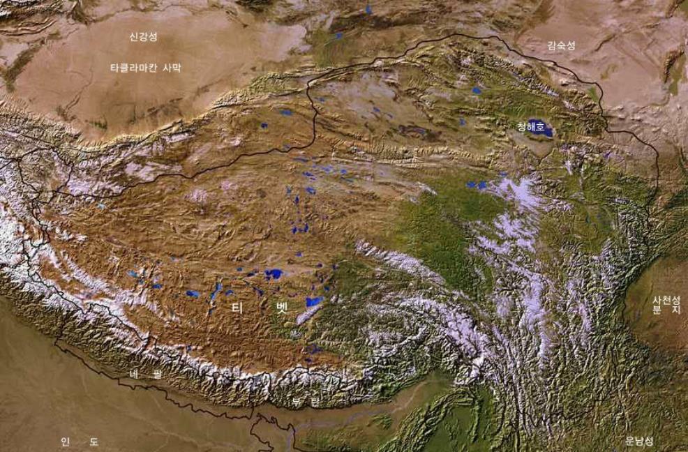
For your reference the Map includes the location of current National Borders and Provincial Borders, as well as the outline of the Borders of the Historic Nation or 'Region' of Tibet.
Further depicted on this Map are Main Mountain Ranges which provide natural borders and limitations in the Region, main rivers and lakes, the location of major Cities and finally, the (estimated) location of several high mountain peaks in this famed Mountainous Region.

Please Browse the Map and follow the Links to more information and Photos of each Location !
Click to go to Full Version !!
Map Tibet Historical Borders
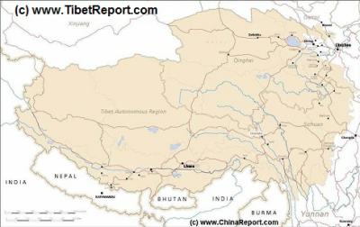
A Schematic Map of Historical Tibet, today Tibet Autonomous Region, Qinghai Province and a part of Sichuan province.
Included for reference are current International Borders, provincial borders, locations and names of main cities and towns, main rivers and lakes, mountains, important Tibetan-Buddhist Monasteries and other places of significance.
Further Reports link to More Photos and History & Backgrounds of each City, Town or Ethnic Community of Yugur, Dongxiang Tibetan, Lhoba, Kazakh, Mongol or others where available.
Today Tibet only exists as Tibet Autonomous Region of China. Tourist visits require an aditional visa !
MtEverest - Qomaloba Feng
Gansu
Shaanxi
Tianshui, Gansu Province
Tibet AR Online Sources
Tibet AR Maps
Tibet AR
Lhasa Landmarks
Lhasa Online Sources
Lhasa
Lhasa Home
Lhasa Hotels
Lhasa Maps
Tibet AR Home
Lhasa Transport
Ngari
Gar Home
China Offline Sources
AsiaReport.com Home
China Report Home
China Online Sources
China Online Store
China Maps
China
China Photo Galleries
China Report Club
Nagqu
Nagqu Home
Qamdo
Qamdo Home
Shannan
Nedong Home
Nyingchi
Nyingchi Home
Xigaze
Xigaze Home
Turpan (Turfan), Xinjiang-Uyghur AR
Nagqu (Tibetan: ནག་ཆུ་རྫོང་། ; Chinese: 那曲县 Shiquanhe), Nagqu County, Nagqu Prefecture, Tibet Autonomous Region, China (PRC)
Salween
Nagqu (Tibetan: ནག་ཆུ་རྫོང་། ; Chinese: 那曲县 Shiquanhe), Tangula Township, Golmud County, Haixi Mongol and Tibetan Autonomous Prefecture, Qinghai Province, China (PRC)
Mazhali (Tibetan: -- ; Chinese: --), Golmud County, Haixi Mongolian and Tibetan Autonomous Prefecture, Tibet Autonomous Region, China (PRC)
Mazhali (Tibetan: -- ; Chinese: --), -- County, Chamdo Prefecture, Tibet Autonomous Region, China (PRC)
Gyêgu, also: Jyekundo (Tibetan: སྐྱེ་དགུ་མདོ་ ; Chinese: Yushu (Town) 结古(多)镇), Yushu City County, Yushu Tibetan Autonomous Prefecture, Qinghai Province, China (PRC)