Ethnic Minorities in Gyantse & Prefecture
Learn More about the Ethnic Nationalities in Gyantse
Gyantse & City Today :
History of Gyantse :
Gyantse Climate & Weather :
Gyantse Basic Knowledge :
To The China Report Main Menu
This page was last updated on: May 30, 2017
The Gyantse Report
45007
Introduction to Gyantse (Xigaze)
Gyantse Landmarks & Monuments
Gyantse & Area Maps
Location : (....)
Elevation : --- Meters.
Surface Area:
Urban - No information available.
City Prefecture of Gyantse - ?? sq Kilometers (?? sq miles)
Population: The Total Urban Population of Gyantse City is around ?? with an additional xxx living in the rural area's of the City Prefecture.
Go to www.drben.net webring
To Main Menu of All Websites at DrBen.Net
ChinaReport.com at
Hi! from Doc Ben and Proud Staff
Alphabetically ordered list of Monuments, Landmarks and other sites of interest in and around Gyantse (Xigaze)
A Full listing of Gyantse City and Prefecture Landmarks, Monuments, Hotspots and other sites of importance in alphabetical order. Search through the list to find your Full Report and Photo-Virtual Tour of each monument or landmark within the City, or Region of Gyantse in Tibet Autonomous Region of China (PRC).
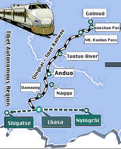
Public Transport in Gyantse
Main Railroad Station of Lhasa - Photos and Introduction
The Main and only Railway Station of Gyantse is ...
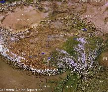
Complete Listing of available Hotels in Gyantse, Xigaze Prefecture, Tibet Autonomous Region, China (PRC).
Click to Go to Large Scale Map 1A
Night Market, Id Kah Square, Kashgar (Kashi), Chinese Turkestan, China
Night Market, Id Kah Square, Kashgar (Kashi), Chinese Turkestan, China Photographic Print
Poole, David
Kirkiz Women on the Pamir Plateau with Traditional Scythes, Kashgar, China
Kirkiz Women on the Pamir Plateau with Traditional Scythes, Kashgar, China Photographic Print
Su, Keren
Gyantse has a Railroad Station.
No information available.
In the - no information available.
Find out the Details in the History of Gyantse
Tibet - Tibetan Plateaux - Satellite Image Overview 1A
A Satellite Image overview Map of the entire Tibetan Plateaux including parts of bordering regions of Xinjiang-Uyghur AR, Gansu Province, Ningxia Hui AR, Inner-Mongolia AR, Sichuan Province, and Yunnan Province. Surrounding nations and Territories are: Myanmar (Burma), Bhutan, Sikkim, Nepal, Bangladesh, India, Kashmir and Pakistan.
This Map clearly defines Provinces and Regions, main mountain ranges, main rivers & lakes of the region, locations of main cities and landmarks.
Tibetan Plateaux Satellite Overview
Satellite Image Overview of the Tibetan Plateaux !!
Tibet AR Online Sources
Tibet AR Maps
Tibet AR
Lhasa Landmarks
Lhasa Online Sources
Lhasa
Lhasa Home
Lhasa Hotels
Lhasa Maps
Tibet AR Home
Lhasa Transport
Ngari
Gar Home
China Offline Sources
AsiaReport.com Home
China Report Home
China Online Sources
China Online Store
China Maps
China
China Photo Galleries
China Report Club
Nagqu
Nagqu Home
Qamdo
Qamdo Home
Shannan
Nedong Home
Nyingchi
Nyingchi Home
Xigaze
Xigaze Home
Soundbonus - Popular Film Theme 'Lhasa at Night', By Philip Glass.
Find DrBen and ChinaReport on Facebook with the latest from www.drben.net.
DrBen Nijhoff | Maak je eigen badge
A Full Google Earth Supported Map of Gyantse

View AsiaReport.com - Mastermap of Asia (entire). in a larger map
Tweets by @ChinaReportcom1
Follow and Respond to us on Twitter :
Tibet Travel Community | Promoot jouw pagina ook
No information available.