Gansu Online Sources
Gansu Maps
Gansu Province
Xiahe Home
Gansu Province Home
China Offline Sources
DrBen.Net Home
China Report Home
China Online Sources
China Online Store
China Maps
China
China Photo Galleries
China Report Club
Wuwei
Wuwei Home
Ganan Prefecture
Zhangye
Zhangye Home
Tianshui
Tianshui Home
Lanzhou
Lanzhou Home
JiaYuGuan
JiaYuGuan Home
JiuQuan Prefecture
Aksay AC Home
Dunhuang City Home
JiuQuan Home
Huixian Home
Longnan Prefecture
This page was last updated on: July 27, 2017
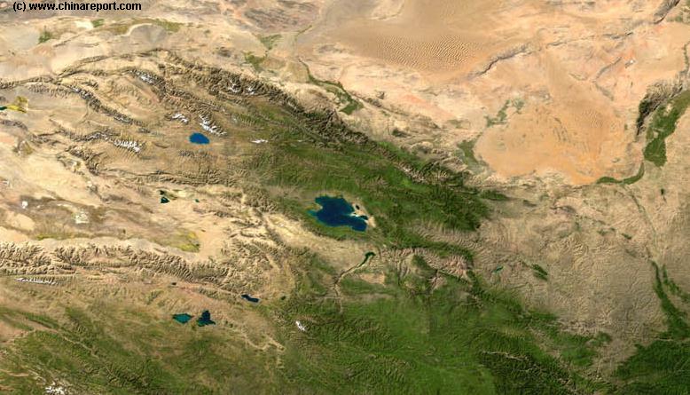
The Adjacent Satellite Image depicts a large Part of Western-Central China. Main Features recognizable are the Gobi Desert of Inner Mongolia AR in the North, The Fertile Yellow Valley of Ningxia Autonomous Region in the North-East, the Green valleys of western Shaanxi Province in the South-East, the green lands and mountains of Sichuan Province in the South and South-West, and extending from the East the distinct features of the Qinghai-Tibetan Plateaux.

Follow the Gansu Provincial border outline as roughly marked on the Map Image to gain better understanding of the odd shape of Gansu Province.
For better understanding and navigation, locations of main rivers and reservoirs, cities, mountains and main
Gansu Province - Maps - Gansu Province Satellite Image Map 1A Overview
Madoi
Hei
River
Hei
River
Wuzhong
Baiyin
Aksay
Yanzhi Shan (3978 meters)
XinTongXia Reservoir
Zhongwei
Yinchuan
Linxia
Gannan
JiaYuGuan
Jinchang
GuYuan
Zhangye
Mati Si - Horses Hoof Temple + Buddhist Caves
YuMen
Dunhuang
Pingliang
Lanzhou
Tianshui
Dingxi
Magu
Xining
Menyuan
Hei Shan - Black  Mountain (1924 meters)
Gansu Province Map Index
Go to www.drben.net webring
ChinaReport.com at
To Main Menu of All Websites at DrBen.Net
The China Report
Big Buddha Temple
Maji Shan
Wei River
BaiYin
Zhongwei Great Wall of China
Liu Pan Shan (2928 meters)
JiaYuGuan Fortress Wolrd Cultural Heritage Site - Great Wall of China
JiuGuan or Jiuquan, Jiquan Prefecture, Gansu Province, China (P.R.C.).
Qilian Shan (5564 meters)
Dunhuang Airport
JiaYuGuan Airport
JingTie Shan (5206 meters)
Lanzhou National Airport
Xiao WuTaiShan (2870 Meters) + Monasteries
Marks location of Special Interest Cultural Historic Site
Marks Airport or Restricted Military Area
Beijing "Capital" - International Airport
Beijing City
Marks City, Town or Village
Xiao WuTaiShan (2870 Meters) + Monasteries
Marks Mountain or Mountain Range & Height in Meters
Sun Gate Pass (Yang Guan) - South-West Gate Han & Tang Dynasty Great Wal of China
Qilian Shan
Xining, Capital  of Qinghai province
JiaYuGuan, Jiayuguan Prefecture, Gansu Province, China (P.R.C.).
Ordos Desert Great Wall of China
Mogao Caves
Qinghai Province
Yellow
River
Hei Shan
BingLing Caves - Buddhist Statues & Murals
Lanzhou City
Gobi Desert
Har Hu
Kuku Nor or Qinghai Hu
Anxi
Dunhuang, Dunhuang Prefecture, Gansu Province, China (P.R.C.).
Mazhong Shan
Sichuan Province
Inner-Mongolia AR
Shaanxi
Province
LiuJiaXia Reservoir
Yellow
River
Yellow
River
Yellow
River
Helan Pass + Plateux
ZhangYe, Zhangye Prefecture, Gansu Province, China (P.R.C.).
Xining National Airport
Moon Canyon
Linxia (Hui)
BaoJi, Shaanxi Province
Zhongwei, Zhongwei Prefecture, Gansu Province, China (P.R.C.).
TianTi Shan (4070 meters)
TengGer Desert
NanHua Shan (XXX meters)
Wu'Du
DingXi, Dingxi Prefecture, Gansu Province, China (P.R.C.).
GuYuan, Guyuan Prefecture, Ningxia Hui Autonomous Region, China (P.R.C.).
Gannan & Tibetan Autonomous Prefecture
MaGu, Gansu Province
Qinghai Province
Sichuan Province
PingLiang, Gansu Province
QingYang, Qingyang Prefecture, Gansu Province, China (P.R.C.).
Hanzhong, Shaanxi Province
NingXia AR
Inner-Mongolia AR
ShuiLian Dong
TianShui, Tianshui Prefecture, Gansu Province, China (P.R.C.).
YuMen
historic Monuments have been marked on the Map, thus further outlining the Province.

As can be understood from the Map Image, Gansu Province lies at the intersection of a great number of impressive natural terrain features and is shaped by these. In the North lie the Sands of the Gobi Desert and its extension the TengGer Desert, creating a Natural delineation of borders in the North with very large Inner Mongolia Autonomous Region. Nearby, in the North-East Ningxia Autonomous Region of the Hui Ethnic Minority is formed by the natural Gorge of the Yellow River cutting through rocks and Sands just West of the Helan High Plateaux, a region accessible by following the path of the Yellow River and by population and landscape clearly distinct from Gansu Province.
The West of Gansu Province has a story all by itself. Here as well, the Borders are delineated by Natural Features of the Landscape. In this case however, the Western Arm of Gansu Province also known as "The Neck (Throat) of China" represents a historical pathway, namely that of the Silk Road Path first explored starting in 138 BC by Court Emmisary Zhang Qian during the Han Dynasty (206 BC - 220 AD). This pathway between two ranges of High Mountains, the Horses Manes Mountains (Mazong Shan) in the North and the Qilian Mountains only some 100 Kilometers to the South has since been named the Hexi Corridor. Lined by Oasis Lakes in an otherwise inhospitable sand and gravel wasteland between impassable mountains, this mountain highway of passes became part of the Chinese Empire during the Han Dynasty with the Northern Borders of these far western regions protected by the Great Wall of China and two garrisons, one stationed at JiaYuGuan and one at Dunhuang. Thus, a final outline for the Province of Gansu was provided.
YongChang Great Wall of China
Jinchang, Jinchang Prefecture, Gansu Province, China (P.R.C.).
YongChang Great Wall of China
Aksay - Capital of Aksay Kazakh Autonomous County, Gansu Province, China (PRC)
Menyuan, Menyuan Hui & Salar Autonomous County, Haibei Mongol Autonomous Prefecture, Qinghai Province, China (PRC).
Anxi
Wuwei
Wuwei, Wuwei Prefecture, Gansu Province, China (P.R.C.).
Jiuguan
Sanguankou - Helan Pass Great Wall of China
Minqin
Lake
This page was last updated on: July 27, 2017
My Great Web page

View AsiaReport.com - Mastermap of Asia (entire). in a larger map
The landscape of Central Gansu Province around Capital City Lanzhou is dominated by the Loess Plateaux that provides the Yellow Color of its Main River, the Huang He, or Yellow River. In The South-West and South, where the Loess Plateaux ends to meet the greener valleys of Central China, lie the naturally outlined borders with Shaanxi Province and Sichuan Province. As a third, extending from far away in the West is the Tibet-Qinghai High Mountain Plateaux, which, where it meets the Loess Plateaux, shaped Mountains that provide another Border for Gansu Province in the West. Along this Mountainous Border many of the Ethnic Minorities of Gansu Province have their homelands.
GanTang, Gansu Province
Wuzhong, Wuzhong Prefecture, Gansu Province, China (P.R.C.).
Yinchuan, Capital of Ningxia Hui Autonomous Region, China (P.R.C.).
Gansu Sources
Gansu Province
Baiyin Home
Gansu Province Home
China Offline Sources
AsiaReport.com Home
China Report Home
China Online Sources
China Online Store
China Maps
China
China Photo Galleries
China Report Club
Wuwei
Wuwei Home
Baiyin Prefecture
Zhangye
Zhangye Home
Tianshui
Tianshui Home
JiaYuGuan
JiaYuGuan Home
JiuQuan Prefecture
Aksay AC Home
Dunhuang City Home
JiuQuan Home
Dingxi Home
Dingxi Prefecture
Gannan Home
Gannan Prefecture
Lanzhou
Lanzhou Home
Huixian Home
Longnan Prefecture
Pingliang
Pingliang Home
Linxia (Hui) Prf.
Linxia Home
Qingyang
Qingyang Home
Jinchang
Jinchang Home
Yellow River in Gansu
Gansu History
Gansu Monuments
Gansu Maps
Gansu Minorities
Great Wall Maps
Historic Maps
Gansu Economy
Yellow
River
Yellow
River
Yellow
River
LongjangXia Reservoir
Madoi (Maduo), Madoi County, Golog Tibetan Autonomous Prefecture, Qinghai Province, China (P.R.C.).
Yellow
River
Source