This Maps Menu gives direct acces to all Great Wall of China Maps used in the China Report Web-site, as well as various maps directly relevant to the Great Wall of China and its pathway through northern China.
To Find even more Maps (Historic, Ethno-Linguistic, Satellite Image, etc) and supporting information please refer to China Maps - Index at ChinaReport.com
A Full Google Earth Supported Map Overview of All Structures of the Great Wall of China from East to West, by DrBen.Net (c) ChinaReport.com and Google.com.
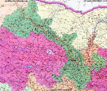
Gansu Province Map 1 - Geographic Map
A Geographic overview Map of Gansu Province entire delineating provincial borders and parts of neighboring Xinjiang-Uygur Autonomous Region Province and Qinghai Province in the West, Inner Mongolia AR and Ningxia Province in the North, Shaanxi Province to the East and Sichuan Province in the South. Includes Cities and Towns (shown by size), Main Monuments & Landmarks of Gansu Province, the flow of the yellow river through Sichuan, Qinghai, Gansu and Ningxia Provinces, BingLing Si, Maji Shan and Mogao Caves UNESCO World Heritage Sites, Main Mountains (with Height), major highways, provincial railroads and main railroad-stations, and main waterways & rivers. This Map further provides links to on site photos and information on the Cities and Main Monuments Other sites will be included in the Future.
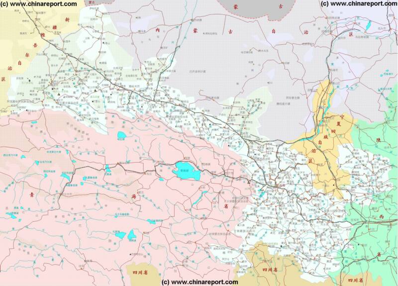
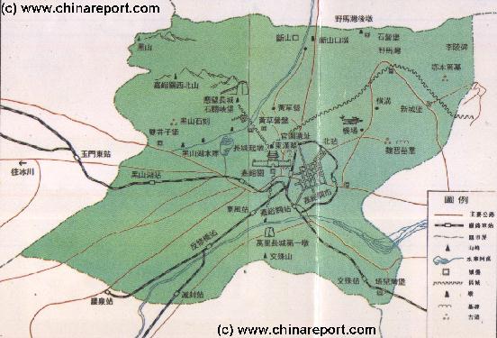
Gansu Province Map 2 - Schematic Map
A Schematic overview Map of Gansu Province entire delineating provincial borders and Main Landscape Features in Gansu and parts of neighboring Xinjiang AR and Qinghai Province in the West, Inner Mongolia AR and Ningxia Province in the North, Shaanxi Province to the East and Sichuan Province in the South. Includes Cities and Towns (shown by size), Main Monuments & Landmarks of Gansu Province, the flow of the Yellow River along the borders through Sichuan, Qinghai, Gansu and Ningxia Provinces, BingLing Si, Mogao Caves and Maji Shan UNESCO World Heritage Sites, Deserts, Mountains (with Height), major highways, provincial railroads and main railroad-stations, and waterways & rivers. This Map further provides links to on site photos and information on the Cities and Monuments.
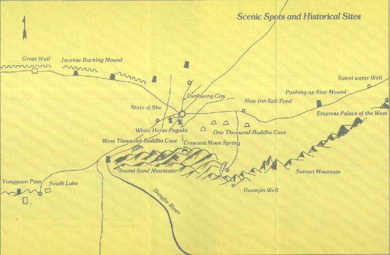
Gansu Province - Dunhuang + Area - Schematic Map
Schematic Overview Map of the City of Dunhuang and surrounding Area's in far western Gansu Province, one of the main destinations for viewing remains of the Han Dynasty Era Great Wall. A 1950's Era Map that depicts the Main Sights, Landmarks and Monuments of the immediate area of Dunhuang as well as the location of Dunhuang's City Center, the new modernized Railway Station of Dunhuang and the nearby Dunhuang City Airport.
Google's Best efforts at information regarding remote and small Dunhuang and Oasis, the home of the Han Dynasty Great Wall of China remnants in China, The Yu Men or Jade Gate and YangGuan or Sun Gate Pass, the two military and civil control points and access gates to the North- and South- Routes of the ancient Silk Road in China.
Use the Google Map, the Satellite Image options and all other available features to find your information, judge the rugged terrain of Dunhuang, Jiayuguan and the Hexi Corrdior and/or even find adresses and streets in the Village.
Google Adds more detail over Time. With Patience this Map will help you along better !
Contribute ? - Upload your Photos, Videos and Information and link it to the Google Map for anyone in the World to appreciate ! Try It sometime, during or after your Travels !
Map of JiaYuGuan Area of Gansu Province 1
A rough Geographic overview Map of JiaYuGuan City and Area of West Gansu Province. Map depicts main highways and roads, JiaYuGuan Airport, main railway lines, mountains and heights, rivers and Lakes as well as main monuments & landmarks of the City & Area. Locations of the Great Wall of China in the Vicinity are included with Links to Reports with more Photos and background information on each site.
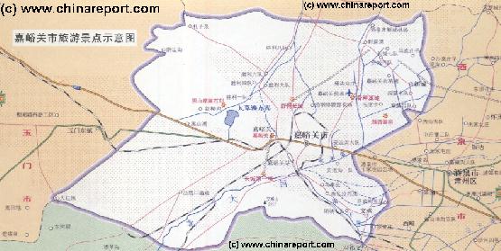
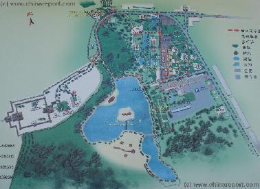
Map of JiaYuGuan Fortress World Cultural Heritage Site and Scenic Zone
Map depicts main scenic sights of JiaYuGuan City and Area, as well as JiaYuGuan Airport. Other locations marked are main highways and roads. main railway lines and the many train service stations surrounding this industrial city, the location of the JiaYuGuan Steel works, nearby mountains, rivers and Lakes as rarely visited sites far outside the City.
Locations of the Great Wall of China in the vicinity of JiaYuGuan Fortress and Citadel are included with Links to Reports with Photos and backgrounds on each site.
A Full Google Earth Supported Map of JiayuGuan by Google.com.
This google supported Map focusses on the ancient city of Jiayuguan, the westernmost end of the Great Wall of China as it existed during the its last period of construction in the Ming Dynasty. Map highlights Jiayuguan Fortress - the core of the ancient city, and marks surrounding landmarks such as the No.1 Beacon Tower of the Great Wall (o/t Ming Dynasty) at steep Taolai River Gorge and the "Extending Arm" Great Wall on the opposite side in the North. Further fortifications and sites of interest found in the wider area are also marked on this map.
Adjacent Map gives direct access to the City of Jiayuguan Map by Google.
Browse around the Map to find the various identified sections such as the two fortresses at Gaotai, the Zhangye Fortress and the various standing Great Wall sections found in Shandan County crossing the border into neighboring Wuwei Prefecture in the East.
Not all section in this area have been marked and identified! Help us along ?
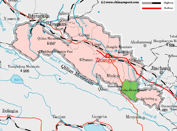
Adjacent Map gives direct access to the City of Zhangye Map by Google.
A Geographic Overview Map of Zhangye City Prefecture within the Hexi Corridor of Western Gansu Province. Apart from it stunning natural wonders such as the Shadan landforms and the alpine grasslands of the foothills of the snowcapped Qilian Mountains inhabited by the rare Yugur Minority, the prefecture of Zhangye is renowned for its ruins of the ancient Great Wall of China. Remains can be found in Gaotai County, Suzhou District (= Zhangye City) and Shandan County. Adjacent Map provides an overview of Zhangye and its counties.
Please browse around the Town of Zhangye and wider Area using our Geographic & Historic Maps. Find out more about the City and Area through our many Photographic Reports on the main historic landmarks and Monuments and their rich history.
Badain Jaran
Desert
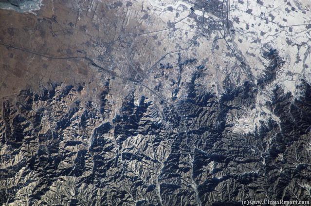
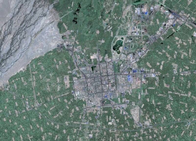
Click the Satellite Image to Go to a Full Version Image & Map.
A Satellite Image of Overview of Zhangye Town with in the Upper-Left corner the flow of the Hei He (Black River) Coming from the South to South-West. Due to damming upstream the outflow is significantly reduced as is clearly visible.
Although the most interesting remains of the Great Wall of China of the Ming Dynasty are found in the remnants of the Zhangye Fortress and its counterpart, upon closer scrutiny various ruins of the Great Wall of China and associated structures such as (broken) beacon tower platforms can be found in the vicinity of the Town of Zhangye and along its outskirts. We are trying to include these location in adjacent Map.
Click the Satellite Image to Go to a Full Version of Image & Map.
A Full Google Earth Supported Map of Lanzhou Great Wall by Google.com.
This Map provides an overview of the large Lanzhou Prefecture of Gansu Province and the supposed locations of Great Wall of China ruins within. As the Provincial Capital and a crucial node of trading routes in the west, including the Yellow River, Lanzhou was the largest and most important strategic city in the region. Surrounded by its own city walls, the city was further protected by layers of the Great Wall of China extending East to West to the North of the City. Further sections of the Great Wall of China extending north to south were identified along the Longying Gorge in the vicinity of the Tibetan Border and near Kumbum Monastery in Xining Prefecture of Qinghai Province.
Adjacent Map gives direct access to Lanzhou & Great Wall by Google.
A Full Google Earth Supported Map of Wuwei Great Wall by Google.com.
Although until recently rarely visited due to the long distances and remote locations involved Wuwei is one of the better destinations within Gansu Province to go hike and find ruined sections of the Great Wall of China. This Map provides and overview of Wuwei Prefecture of Gansu Province and the many identifyable locations of the Great Wall of China within. Traditionally the main site can be found at xxx Pass in Gulang County, the Great Wall ruins continue along the north-east flank of the main town of Wuwei and extend almost as far as the Minchin Lake, a crucial startegic watersource due north of Wuwei in the Alashan Desert.
Adjacent Map gives direct access to Wuwei & Great Wall by Google.
A Full Google Earth Supported Map of Jinchang Great Wall by Google.com.
This Google supported satellite image Map of Jinchang Prefecture in Gansu Province provides an overview of the Great Wall of China sites within the Prefecture. Most currently identifiable remains can be found in Yongchang County to the south of the city town of Jinchang. Not all surviving sites may have been marked on this Map.
Browse the main sites. Help out and identify more?
Adjacent Map gives direct access to Jinchang & Great Wall by Google.