Taken from the Fortress the route easily becomes clear. The Fortress was strategically constructed so sit on the highest point in the plain and is situated roughly halfway between the overhanging Great Wall and the Taolai Gorge. To find the Gorge,althoughasacrackintheearthitisnotvisible, one simply needs to follow the Wall that extends southward from the Fortress leading seemingly towards the far Qilian Shan Mountain Range.
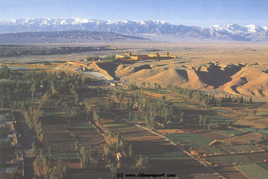
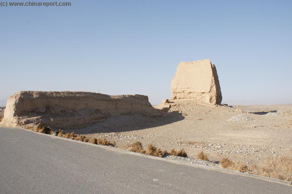
Above + Right: The Great Wall of China Fortress of Jiayu Pass as seen in November 2007. An extension of the Fortress wall runs from its South-Western corner through the arid plain to the Taolai River and its steep Gorge, an impassable barrier in the Hexi Plain.
This page was last updated on: July 30, 2017
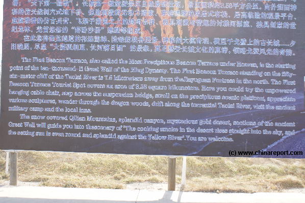
TheNumberOneBeaconTower at Taolai River Gorgeisconsideredtobethewestern-mostpointofthedefenses of the Great Wall of China astheywereinfunctionduringmostof theMingDynastyEra(1368AD-1644AD).Inpractice,thefirstbeacontoweroftheGreatWallisbutanextensionofthegargantuanFortressofJiayuPass(JiayuGuan),whichformedtheWestern-mostGateoftheChineseEmpireandwasabordercheckpointforallthosetravelingalongtheSilkRoadin-andoutofChina.In thoseancienttimeslong gone itwasconsideredtheultimateendingpointoftheChineseRealm. Although no dramatic events of war,sweepinghistoricevents, nor timeless poetry or song can be attached to the
JiaYuGuan Great Wall of China - Taolai River
(1) Road to Great Wall of China and No.1 Beacon Tower
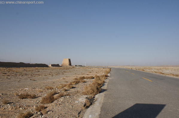
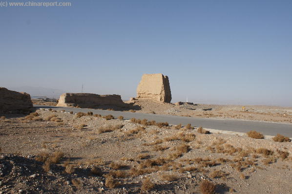
Above: Today a railway line intersects with the mud remnants of the wall south-west of Jiayuguan Fortress. The Line is not the main Lanzhou to Urumqi Railroad but a smaller line which turns into the Mountains.
History and Significance of the Taolai Gorge and the First Beacon Tower at Jiayuguan :
The smallandremotebordertownofJiayuguanisfamous in the history of Central and Eastern Asia as the western border crossing of the Silk Road into China.Itwassore-establishedaroundtheyear1368AD,whenMingArmiesdrovethelastMongolianLoyalistTroopsoftheYuanDynastyoutofChinathroughtheJiayuPass.Consolidatingit'sgainsoverashortperiodthereafter,theMingthendeclaredtheirMingDynasty(1368AD-1644AD)with its Capital at NanjingandforthwithorderedamassivereconstructionandreinforcementplanfortheGreatWallofChina.Crucially,thisplanincludedtheconstructionofmassiveBastionattachedtotheGreatWall,afortressbuilttoserveasamilitarybaseaswellasastop-gaptorulethe strategiclyvitalPass.
The Year 1368 AD however was by no means the first time that these regions had formed the outermost
border area's of the Empire. No, much earlier, already during the Han Dynasty (206 BC - 221 AD)Jiayuguan and even Dunhuang (blazing beacon) beyond had been included as the border area's of the Empire. What lay beyond, at the time that meants beyond the Jade Gate and the Sun Gate outside of Dunhuang was truly wild territory inhabited by fierce nomadic tribes and other sorts of 'barbarians'. What lay inside of Dunhuang in
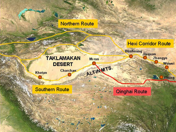
Schematic depiction of the main pathways o/t silk road passing along the north-rim of the Giant Tibetan Plateaux and the secondary path bypassing the Hexi Corridor through Xining.
Map of the Han Dynasty Empire (206 BC - 220 AD) at its highpoint. Clearly visible on the Map are the outlines of Gansu Province and the Strategic Hexi Corridor leading West. In the South-West Han Chinese are at the Dadu River, for almost 2 millenia the border with Tibet.
- Mouse over Image -
what is called the Hexi Corridor was officially Chinese Territory with its own Military Administration at first, later followed by Civilian Administration. In those early years several Han Armies were stationed along the Hexi Corridor, near Dunhuang with the strategic goal of dominating the area beyond. And so it happened, laying the foundations for what much much later became known as the Silk Road.
One Man sheltered from the winds by a small canvas tent watches over traffic at the crossing at all Times.
the famed beacon tower is an absolute must-see when visiting the modestly sized City of Jiayuguan and its Fortress. Find it located at only a small distance South South-West of Jiayuguan, as can clearly be seen on accompanying maps.
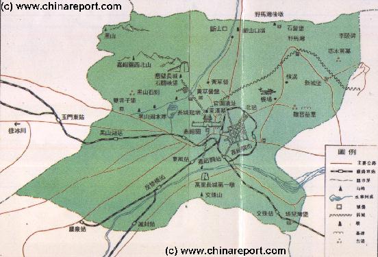
Overview Map of JiaYuGuan City and Area 2
A schematic Map Drawing of JiaYuGuan City Prefecture in Gansu giving a complete overview of JiaYuGuan City, the location of the Fortress UNESCO World Cultural Heritage Site and the construction of Great Wall of China Defenses in the immediate vicinity such as the Overhanging Great Wall and No.1 Beacon Tower.
Follow the links to navigate along each individual section of the Last Bastion on the Great Wall, and the attached Recreational Area.
AmongthefamouspersonsthatsawtheFortressinoperationareBentosDeGois,ajesuitpriest and Papal EnvoywhodiedatnearbyJiuquan(Suzou)theadministrativecenterandherdingpointforallthoserequestingpermitstotravelfurtheronintoChina.
GorgeoreventhepresenceoftheTaolaiGorgemayremainentirelyunclearduemainlytothegeographicalfeaturesofthelocallandscape.ThebestexplanationforthisphenomenonistosaythatatthispointinsidetheHexiCorridor, theplainisrelativelyflatandapartfromafewlowhillsandtoweringmountainsonthehorizonquitefeatureless.Furthermoreatmosttimes,thesimmeringheatcombinedwithglareofsunlight makesviewinganythinginthedistancequitedifficult.Therefor,thissteepgorge, in fact asheerdropcarvedoutoftheloessgroundisnotclearlyvisiblefromanywhereintownofevenfromtheFortress.
ThebestwaytoorientateonesselfonitslocationistostartnavigatingfromtheJiayuguanFortressitself,thecenterofthelocaldefenses. In this respect, a visit to the No.1 Beacon Tower combines well with a Tour of the Fortress. A reasonable order would be to head out to the Northern edge of the defenses at Jiayuguan, which is formed by the (reconstructed) 'overhanging arm great wall of China'. From there head southward to the Fortress which is clearly visible at all Times. Take a lenghty tour of the Fortress, then once more turn South-ward to end your sightseeing with the Taolai Gorge spectacular, which can even include a breath-taking zip-ride on a cable across the Gorge.
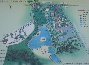
Map of JiaYuGuan Fortress World Cultural Heritage Site and Scenic Zone
A Map Drawing giving a complete overview of the JiaYuGuan Fortress UNESCO World Cultural Heritage Site and recreational Area in JaiYuGuan, Gansu Province of China.
Follow the links to navigate along each individual section of the Last Bastion on the Great Wall, and the attached Recreational Area.
An old photo of the Jiayuguan Fortress taken from the North and the vicinity of the overhanging arm great wall site. From this vantage point the wall running south across the plain seems to lead towards the Qilian Mountains, however a gorge runs in between.
well-connected. From the fortress, simply hire a cab and instruct your driver to follow the road along the Wall to the Gorge. Following this route one gets a further sense of the military arrangements taken in
As can be made out from adjacent and other maps, immediately south of the Fortress is butwhatseemslikewasteland. Through this cut a few roads and railways.
To be exact, driving instructions from the Fortress to the No.1 Beacon Tower are as follows: First, drive out of the main gate of the large parking space reserved for the Fortress and turn south (SSE) ward until reaching the intersection with the next main road, which is Lanxin (Lanzhou to Xinjiang) West Road. Then, turn right and head westward along Lanxin West Road. Not very much further, this road is joined by the G312 provincial road which comes from the south and makes a steep bend to actually extend in the same direction as the earlier Lanxin West Road. You are now officially outside the city limits.
The rest of the route follows fairly easy and there is not much fear of taking a wrong turn. There are none.
Head further down G312 provincial road and cross via a small tunnel underneath the first railroad line, which is by chance the main railway line in these regions connecting Lanzhou in Gansu and Urumqi in far western Xinjiang-Uygur Autonomous Region. It has just been modernized to carry China's modern bullet trains past this spot and beyond to Anxi, Dunhuang, Hami (Kumul),Turpan and Urumqi.
You might want to stop and wonder at this modern marvel.
Railway crossing at the Great Wall of China in the plain outside of Jiayuguan. An eroded but still massive mud watchtower still reminds passers by of the significance of the location.
Heading into the plain one does get the peculiar sensation of turning ones back on the last bits of civilization and heading into a seemingly endless desert-like plain which is nevertheless bordered behind by some incredibly steep and high snowcapped mountains. Anyone not used to these surroundings indeed does feel like crossing some sort of invisible border beyond of which lie undoubtedly rough lands in which life is considerably harder.
To the South extends the Tibetan Plateaux, of which the
ancient times for the defense of this strategic spot in the Hexi Corridor. Although the Fortress stood atop a Hill overlooking the plain, at the same time dominating the high ground and protecting the local water-source, this by no means ensured that the vital hexi mountain corridor leading eastward into China was entirely closed off. At least not physically. Thus, after the central core of the defenses, the Fortress, was complete, more defensive structures were added radiating out from the Fortress.
In the immediate vicinity, the overhanging arm great wall on the northern extreme served to block off a narrow mountain pass, which when used by attackers could help to outflank a large part of the forces assembled at the Fortress to face west. In the South, the
Great Wall itself was extended from the Citadel to cut all the way across the Mountain Pass and end at the foot of the Qilian Mountainsinthefardistance. Just a few kilometers from the Fortress this wall, in essence the Great Wall itself, is intersected by the Taolai Gorge which
was the location of the First and westernmost Fire-beacon tower of this widened line of defense.
Qilian Shan are only the most outer 'foothills'. They do not impress as foothills but as darkly towering guardians of a forbidden and icy world.
Beyond the Fortress and the Wall in the West extends nothing but a widening plain and a featureless simmering horizon. No vegetation to speak of appears anywhere in sight.
In the North the dusty and uneven tops of the Mazhong Shan, beyond which lie treacherous sands and desert of the Gobi within Inner-Mongolia, seem equally unattractive. Even today the landscape feels like it might be a last bastion and outpost of Civilization.
Just slightly beyond this railway track the G312 reaches a smaller freshly paved road which turns off to the South. Turn off and follow this road.
The road you are now traveling on has remained nameless so far but was constructed solely for the purpose of reaching the No. 1 beacon tower.
After about 1.5 kilometers one comes to the newly constructed and fully modern Lanxin Highway (here:z4 Qingjia Toll Expressway) and passes over it to be confronted with a final obstacle on the valley floor, a second railway line. This second line is a minor branch of the main Lanzhou to Urumqi railroad, and mainly carries men and materials back and forth from the mining establishments and a small village known as Sanchakou on the slopes of Qilian Shan. Nearer the mountain the (south) line joins up with the Beida River which stream it
follows up to the Gletsjer to terminate at Sanchakou and a bend of the S215 provincial road high in the mountains. This is the train ride to catch when planning mountaineering adventures on the mountain.
As mentioned, this is the last real obstacle in a total journey of around 8 kilometers. Only some 500 meters from the railway intersection, just inside the mud-wall one is stopped by the official tourist guard of the needs to pay an admission fee, after which the car is allowed to follow the small road and end up at the Taolai Gorge and last (or first!) Beacon Tower now visible in the distance.
A Full Google Earth Supported Map Overview of All Structures of the Great Wall of China from East to West, by DrBen.Net (c) ChinaReport.com and Google.com.
This page was last updated on: July 30, 2017
My Great Web page
very tower itself, withitsdramatic poetry or song can be attached to the very tower itself, withitsdramaticsceneryofawatch-tower overlooking a fast flowing river inside a steep Gorge, today the