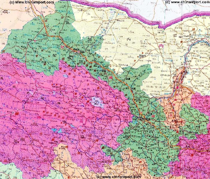
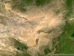
Satellite Image Map of the Gobi Desert Region. Map overviews North-West Xinjiang Autonomous Region, Mongolia, Inner Mongolia and North and North-Eastern China giving a Full Overview of the Gobi Deserts and Yellow River Basin. Map includes location of Lanzhou in Gansu and other Cities (clearly visible).
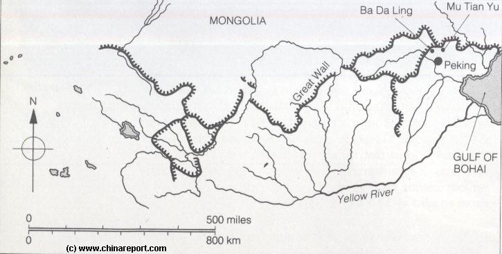
A Schematic Map of the Several Layers of the Great Wall of China defenses as they existed during the Ming Dynasty (1368 AD - 1644 AD) in Gansu, Qinghai, Ningxia, Shaanxi, Shanxi and Hebei Provinces. Map includes location of + link to Great Wall Passes as reported on by ChinaReport.com. Mouse over & Click Links for more Information and Photos.
Yang Guan Pass
Jia Yu Guan Pass
X
YanMen Guan Pass
Pian Guan Pass
Ordos Desert
TengGer Desert
Taklamakan Desert
Gobi Desert
Gobi Desert
Gobi Desert
Ngoring Hu
Wei River
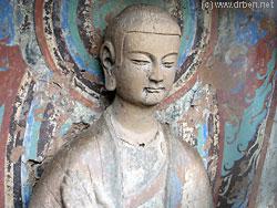
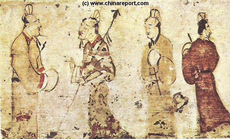
Detail of a Tang Dynasty Era Statue at the Mogao Caves, at Dunhuang in Western Gansu Province.
Schematic Depiction Gansu Province and Districts. This Map conveniently depicts the 3 zones of Topography and Climate : The green and wet south, the arid central section of the Hexi Corridor and the Desert West with Dunhuang Oasis.
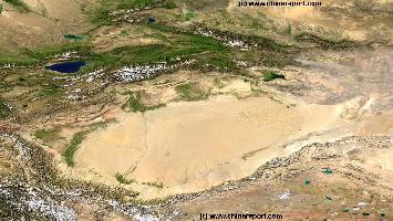
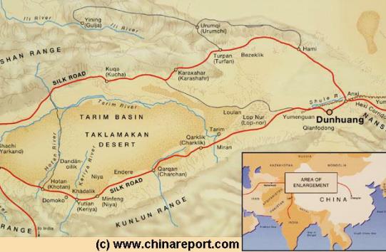
China Report - Map o/t Taklamakan Desert & Tarim River Basin
A Satellite Image Map of the entire Taklamakan Desert and the Tarim River Basin in Xinjiang-Autonomous Region of Western China.
Map gives explanation and backgrounds to Local Geography, the Flow of the Tarim River from the Pamir Mountains in the West to Lop Nur (Dry) in the East, ancient Oasis Cities of the Tarim Basin and Taklamakan Desert, the North and South Routes of the Silk Road in this Area, Past and Current Climate and Historic Backgrounds.
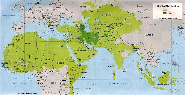
Asia Report - Maps - Distribution Islamic Faith Asia, Africa , Europe
A Geographic Map depicting the Distribution of the Islamic Faith in China and Asia, as well as Europe and the majority of the continent of Africa.
Sunni Islamic Areas are depicted in Green, whereas the Shia (Minority) Areas are depicted Darker Green.
The predominantly Muslim Xinjiang-Uygur Autonomous Region of China, Parts of Gansu Province and Small Ningxia Hui clearly stand out as the main muslim areas in China.
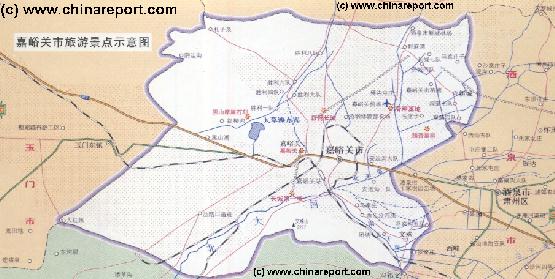
Map of JiaYuGuan Area of Gansu Province - Click to go to Full Version
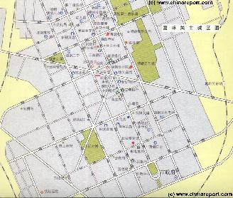
Map of JiaYuGuan City - Navigate most Sites within the small City of JiaYuGuan, Gansu Province - Click Map to go to Full Version
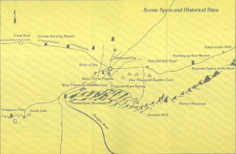
Map of Duhuang City & Area - Navigate most Sites situated around the small City of Dunhuang, Gansu Province - Click Map to go to Full Version
Maji Shan, the Buddhist Holy Mountain near Tianshui, in Eastern Gansu Province.
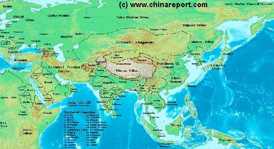
China Report - Map of Ancient Asian Empires and Tribes in Asia 565 AD
An overview Map of Asia Entire clearly dmarkating the Territories, Nations and Tribal Area's of the Continent in the year 565 AD. Japan is split between the Yamato Kingdom and Emishi. In Korea three Kingdoms Rule among which the largest Goguryeo. China is split in a Northern Dynasty of the Qi, and a Southern Dynasty of the Chen.
While in the Far west the Qi Empire stretches as far West as Dunhuang, the Silk Road is temporarily blocked by the unification of Mongol Tribes in the Gokturk Khanate and the appearance of the small XiYe City State in the Tarim River Basin.
Mazhong Shan
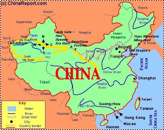
Image: Rough Schematic Map of China, the Path of the Great Wall and its relation to Cities, Nations, Rivers and the Pathway of the Ancient Silk Road in China with Lanzhou as the crossing point of the Yellow River.
The Long March entered Gansu Province in fall of 1935 AD, with the last groups entering the Province as late as March of 1936AD. After trecking through the disastrous grasslands and bogs of Tibetan dominated western Sichuan, they entered Gansu through Hadapu Village in the South-West of the Province, a part of Linxia Hui Autonomous County. (The Hui are a Muslim Ethnic Minority of China).
After fighting their way through 10.000 Li of hardships, battles and starvation already, the Communist Army now entered a complete new landscape
From the Village of Hadapu in the South, the Path of the Long March basicly followed the contours of the Great Wall of China leading North and slightly East. However, the main marching route passed through well south and east of the Provincial Capital of Lanzhou. It lay someways East of Huining.
In North-East Gansu, on the border of Ningxia Hui AR and North-West Shaanxi, in the barren Ordos Desert, the Red Armies passed through the Village of Wuqi, their entry point into what had turned out to be a modestly sized Communist Base established by one Liu Zhidan. Liu was a local Hero who established the base and by his acts, saved the small Communist Army on its desperate retreat from its Jiangxi Base in the South and from ever pursuing Nationalist Troops. Hence, the Village is named Zhidan not Wuqi today. Much of the local Culture is devoted to this folk Hero and Legend.
Tragically however, Lui Zhidan was killed in action not very long after Mao, The Communist Central Committee and their starving armies found the North-Shaanxi Communist Base (10 October 1936 was marked as the End of the Long March, Lui Zhidan died within 6 months after).
As the official story goes this left Mao and the Party to carry and save the Base as well as the Communist Cause. The death of Lui Zhidan however seems at the very least not inconvenient for those in the centre of political power within the Central Committee.
Some sources claim Lui Zhidan was killed by his own, thus removed from the scene to leave the Stage and further Political Glory to Mao and the other high Party Cadres Zhou Enlai, Deng Xiaoping, Lin Biao,Bo Gu, and others.
Lui Zhidan had been a God to his People and could thus claim great popular influence. As establisher of the Base he could claim political seats in the Communist Party Leadership and with his very own Army, he could install his own Men on high places already held by other ambitious and often quite ruthless Men hardened by the horrific realities of the Long March and Civil War as well as political purges and infighting within their own ranks.
Curiously, it was not only Liu Zhidan himself who died. At least two of his bodyguards found their equally suspicious deaths in the same incident, and later - some other high officers in Lui Zhidans remaining army were killed as well.
This situation receives little historical attention in most histories of the Long March as it has been politically taboo withing Communist Party History to even investigate the circumstances around the Death of Liu Zhidan and interview the people involved. Mao had concluded what had happened - the death was on the battlefield and a regrettable but heroic death for the communist cause- , and not Long after Mao made his Rise to Considerable Political Power as the Central Leadership of the Communist Party and the Man behind much of its Philosophies and practices, most notably Propaganda. For 50 years the matter was completely Taboo and Mao carefully arranged that no investigations were made.
Whatever happened in reality is thus unknown. It does however seem rather peculiar that Mao was bend on complete secrecy on this issue.
It is even more noteworthy considering that the Folk Legend already established around Lui Zhidan, the role of Saviour and Man-God Leader over the peasants destiny, passed on the none other than Mao Zedong, who carefully nurtured it for his own propaganda aims. For instance: the internationally known Revolutionary Classic Song "The East is Red" was in its original version a folk song, and rewritten dedicated to the Glory of Lui Zhidan, not Mao Zedong.
As the saying goes, the rest of the story is history. Over the years the Liu Zhidan story was cultivated by Mao into a personal idolation by his "Masses" that would run nation-wide and soul deep. Through the death, blood and sweat of Liu Zhidan and many others, Mao Zhedong appeared in the Chinese Sky as the Political Sun that would provide Leadership and hope to a Nation long deprived of any such things.
In what can be considered a side-show of the Long March, in the battle of Ningxia, the 4Th Army led by Zhang Guotao, a rival for party control, was send into what was to be the Battle for Ningxia. The taking of Ningxia was planned to bring contacts with the Soviet Union, and enable resupply of the downtrodden and fragile Chinese Communist Armies. However, the battle was soon aborted, however due to curious defaults in communications with the 4Th Army, it was never notified of the cancellation of the Battle Plan. Thus the 4Th Army marched westward on a lesser know section of Long March. The pathway up the Hexi Corridor into hostile Muslim Dominated Area's was a death march through a moonlike landscape, under tormenting climatic conditions and continuous assualts by local warlord troops. The 4Th army was nearly completey annihilated in a final battle at Gaotai west of Zhangye, leaving not more than 4000 ultimate survivors who went through the worst humilations and hardships.
Many of the 4Th Army Memorial Sites are very worthwhile, but unfortunatly located in remote and barren places. Yonchang, sishi li village 40 miles east of Yongchang - and at Wuwei, at Gaotai near Zhangye and Liyuan Kou - site of a high pass into the Qilian Shan Mt Range and scene of the final battle and retreat, all inside the impressive Hexi Corridor.
and environment, the barren and dry lands of the Gansu Loes Plateux, full of dust, lacking in water and food, and with hardly any trees in sight. It was a tough place to live and after the armies were done marching through their path had been turned into a moonscape stripped of its few trees for firewood, and with all edibles and provisions used and gone.
Anxi
JiuQuan
Dingxi
Lanzhou
Gannan
Linxia
A Full and complete Map of China (PRC) identifying all Language Areas big and small in all Provinces and Autonomous Regions of China.
Map includes Turkic Languages (Uygur, Kazakh, Kirghiz, Salar & Uzbek), Mongolian Language and Sub-Divisions (Mongol, Tu, Daur and Dongxian), Tungusic Peoples (Oroqen, Evenki and Xibe) and Languages, Korean, Tajik (Tadzhik), Mon-Khmer (Kawa + Puman (or Pulang)), Hui, Uygur (Uighur), Tibeto-Bhurman Languages, Tai and Miao, Yao and She' Language Area's and Borders. Main Area's and sub-divisions of Han Languages (Northern Mandarin, Eastern Mandarin, South-Western Mandarin and Cantonese) further included. This color-coded ethno-linguistic Map (of 1967 AD) identifies at a glance most ethnic minority regions in China
Map China Ethno-Linguistic / Language Distribution China
The Capital of Gansu Province is the City of Lanzhou, since before recorded history a settlement on a convenient crossing point on the wild and often untamed Yellow River. Lanzhou Today is a foul aired industrial city of millions , a true capital of remarkable highrises with the 2.8 million population stacked and concentrated along the narrow river banks at the bottom of the Yellow River Gorge cut by the River in the Loess Plateaux that sets the main landscape and scenery here. Except for the everflowing Yellow River with its magnificent bridges and the Gansu Provincial Museum, Lanzhou City itself has few sights to offer and even fewer remaining historic landmarks. There is a Yuan Dynasty Era Temple and Dagoba on the Hilltop overlooking City and River, a modern day Mosque for the Hui Islamic Minority, the Qing DynastyWhite Cloud Temple and little else. A New Modern City Square has just emerged. In the surrounding and outlying area's of the Province there is plenty to see. The air quality is remarkably better as well.
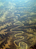
Yellow River snaking through the Loess Plateux in North-Eastern Gansu Province.
Gansu during the Mongol Yuan Dynasty:
In the 13Th Century the large extenses of Gansu Provinnces Hexi corridor and the pathways of the Silk Road served as the conduit for Marco Polo to travel into China.
By the Time of the Qianlong Emperor of the Ching Dynasty the Shanxi Merchants and their various monopolies had made Shanxi Province the wealthiest province of the prospering nation, with more cash silver teals than the Imperial Coffers. Shanxi Businessmen controlled trading as far as Dunhuang in far Western Gansu Province, Xinjiang and well into area's now part of the Capital of the Republic of Mongolia. In the wake of their trade Chinese Han Culture, new technologies and Shanxi's Influence followed.
Gansu during The Peoples Republic of China:
In 2007 north-western Gansu saw the forcible relocation of hundreds of thousands of Tibetan herders.