recorded about the town or location of Baiyin in this early time.
The region was occupied by the Tuabo Kingdom of Tibet during the end of the Tang Dynasty to the beginning of the Song Dynasty.
During the Song Dynasty the regions of Lanzhou, Baiyin and the fertile Ningxia plain of the Yellow River were already an important regional crossroads, it lands continuously contested and prized for their strategic position and value as grazing lands for war horses. The Song largely held on to Baiyin, but were in defense against the (semi-)Tibetan Tanggut people who occupied the lands to the north as well as the west, and the Khitan Liao Dynasty in the north and north-west. Later the Liao were defeated by the Yurchen Jin Dynasty arising in the north after which the Great Genghis Khan and his Mongol Armies conquered all, unifying the steppes to the north with the Chinese heartlands to the south of Baiyin.
Baiyin City & Prefecture Hotels
Ethnic Minorities in Baiyin & County
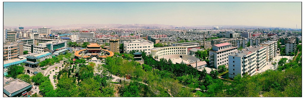
Baiyin City & Prefecture Today :
History of Baiyin :
Baiyin Climate & Weather :
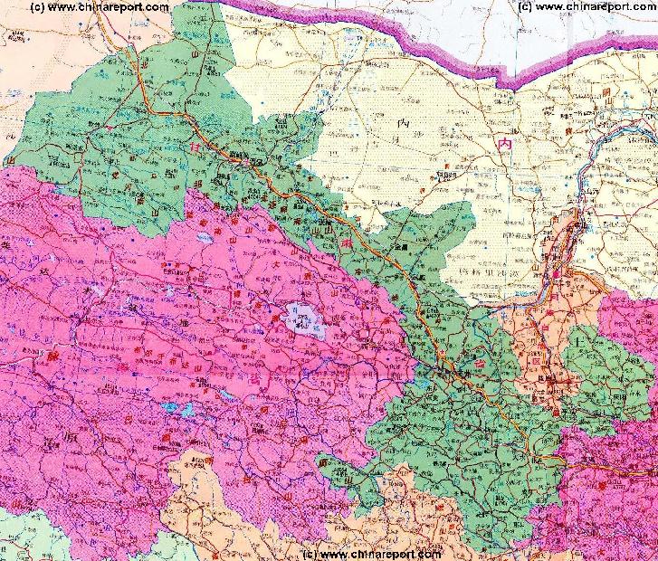
Geographic & Historic Maps on Baiyin, Silk Road and related Regions of Gansu Province.
This page was last updated on: August 3, 2017
The Baiyin Report
Introduction to Baiyin (白银市) City & Prefecture
Baiyin Landmarks & Monuments
Baiyin & Area Maps
The City of Baiyin is situated in Gansu Province of China (P.R.C.) and is located at a short distance almost due north of the provincial Capital of Lanzhou. Neighboring territories are; the silk road destination of Wuwei and Prefecture of Gansu Province to the north west, Zhongwei Prefecture of Ningxia Hui Autonomous Region to the north east, Guyuan Prefcture of Ningxia to the east, Dingxi Prefecture of Gansu Province to the south and finally Lanzhou the provincial Capital and its elongated Prefecture to the south west and west.
The main river in Baiyin Prefecture is
The China Report
The Baiyin Report is part of the overall website www.ChinaReport.com & www.drben.net
Learn about what is new on this Site from below window.
ChinaReport.comat
Please browse around the Town of Baiyin and wider Area using our Geographic & Historic Maps. Find out more about the City and Area through our many Photographic Reports on the main historic landmarks and Monuments and their rich history.
LANDMARKS OF BAIYIN CITY:
No information available.
Baiyin Transport
Baiyin has one main railway station and easy access to a Regional airport. The nearest airport can be found due west of Baiyin City at Tianzu Village at only 46.7 kilometers distance.
The city of Baiyin is connected to the provincial Capital of Lanzhou via the G6 Jingzang Expressway which connects to G30 Danla Expressway leading southward to Lanzhou. Driving time to Lanzhou is under 1 hour.
In addition to the large expressway, tthe G109 National Road connects fom G30 Expressway (Danla - section: Liuzhong / Lianhuo) to lead northward to Baiyin from where it continues to Pingchuan (District), the secondary urban district of Baiyin Prefecture.
Elevation : Baiyin City: 1,698 meters (5,571 ft) ; Prefecture: The terrain is higher in the north and south parts having a elevation of 1275 meters to 3321 meters.
Surface Area of Prefecture: 21,209 km2 (8,200 sq miles). Urban: 3,478 km2 (1,343 sq miles).
Population: The Total Population of Baiyin City and its Prefecture was counted at around 1.8 million in the year 2010 census, up from 1,670,000 (urban 270,000) in 1996.
Moon
Canyon
Today's Baiyin is an out of the way city which is not visited by may foreign tourists or outsiders. In China Baiyin is mainly renowned as a mining city, but nowadays it isalso an imprtant logistical center an supply hub for the Provincial Capital of Lanzhou. Although the city is situated reasonably close to the Capital Lanzhou and may even be considered a far flung outer suburb of it, life in Baiyin is very different from that in the Capital.
There are no well-known historical landmarks in town and outside of the city are few sites of interest to visit. The City of Baiyin is not mentioned in most standard travel guides for China such as Lonely Planet, Fodor's Guide, etc.
ADMINISTRATIVE DIVISIONS:
The city of Baiyin currently consists of 2 urban districts. Outside of his expanding urban zone lie 3 rural counties.
The two urban city districts are the Baiyin District (白银区) and the Pingchuan District (平川区). Taking the aiyin District as the original city district, the Pingchuan District of the city extends in an odd way eastward from there, by ow dividing the Jingyuan rura district in two sections, one to the north of Pingchuan District and one to the south of it.
The three rural Counties of Baiyin City Prefecture are; Jingtai County (景泰县) - situated due north of the city, Jingyuan County (靖远县) - to the north east and south east of the city, and finally Huining County (会宁县) - making up the south eastern tip of Baiyin Prefecture.
Huining County is the largest county in the prefecture.
Altogether, the three rural counties count 64 townships, 18 towns, and 7 sub-districts.
FACILITIES IN BAIYIN CITY:
No information available.
There reportedly are 2 radio stations and 3 television stations situated in the city of Baiyin.
Medical Facilities: No information available.
Education:
No information available.
ECONOMY OF BAIYIN:
Baiyin is situated at the center of what is known as the Longhai and Lanxin Economical Zone a provincial economic developing zone situated near the regional National Level Airport of Lanzhou at Zhongcuan. As a medium-sized city in Gansu Province (Gansu), one of the 12 less-developed provinces and autonomous regions targeted under the Western Development Strategy of the People's Republic of China (PRC). Since the year 2010 the city has gained renewed attention from the central Government.
The service sector generated value-added output of RMB 11.8 billion in 2011, accounting for 31.39% of the city's total GDP.
Mining Industry in Baiyin:
As mentioned, Baiyin is historically known for its silver and gold finds. Today's Baiyin is still known to be rich in mineral deposits and the prefecture has a well developed mining industry. According to Government sources there are more than 30 kinds of metal and nonmetal minerals identified in the prefecture, among them also so called "rare earth minerals". The most important among the minerals found in Baiyin Prefecture are curently copper, zinc, gold, silver and coal. Increasingly cryolite, electrolytic copper, palygorskite and various rare-earth metals are being exploited.
More pecifically, the reserve of coal within Baiyin Prefecture is estimated at around 1.4 billion tons. In addition some 0.2 billion tons of It got its name 600 years ago for Baiyin Factory, an official institution which handled the excavation of gold and silver and 1 billion tons of limestone are being exploited in the area.
In addition to its primary mining industry Baiyin is the home location of a whole chain of additional industries. In this respect Baiyin is a an important coal base of Gansu Province as well as a large industrial base of nonferrous metal. A lot of key enterprises have been built since the founding of the Peoples Republic of China in 1949, Beginning in the 1950's and accelerated during and after the so called "Great Leap Forward" in 1958, the region was designated as a key industrial area to be serving the "Oil and Petro-chemical" City of Lanzhou. Local industries such as Baiyin Nonferrous Metal Corporation, Northwest Copper Processing factory, Gansu Rare-earth Corporation, Jingyuan Bureau of Mine, Yinguang Chemical-industry Corporation, Baiyin Phosphate Fertilizer Factory all date from this era. Together these local industries form a complete industrial system, based on nonferrous metal, accompanied by other industries like coal, chemistry, textile and machinery.
Baiyin Corporation produces copper, aluminum, lead and zinc. Gansu Rare-earth Corporation produces chloride rare earth, a sector in which it ranks first in Asia.
Jingyuan Bureau of Mine and the other coal mines have an annual output of over 6 million tons of coal.
Although one may wonder about the quality giving the abundance of mining industry in the area Baiyin is alo known as a original source for healthy mineral water. The supposedly healthy water containing useful trace elements is found in Huining County of Baiyin Prefecture. Most likely however the water also contains traces if not considerable amounts of heavy metals such as zinc and lead.
Agriculture:
The Gansu Provincal Government lists Baiyin as having 6,682,000 mu of cultivated land, 20,000,000 mu of grassland and 1,290,000 mu of forestry. Crops grown in the Prefecture include wheat, maize, Sorghum (Milet or gruel), rice, etc.
Although the Provincial Government boasts the Baiyin Prefecture as a model of agricultural production, in reality one may wonder about the quality of the prouce grown in Baiyin. As much of Baiyin is historically known as a notorious and poor arid region, situated mostly on the less plain of the ellow River, few rives flow through the Prefeture. In an effort to raise crops on the loss plain regardless, the Government has launched a scheme which "Makes full use of the water resources of the Yellow River", a once mighty river now not so muh known for its wild torrents and sediment laden yellow waters, but mostly for its dwindling waters and its high indusrial polution rate.
According to the ambitious plan to improve the agricultural yields of the region, Baiyin has subsequently developed the new agricultural form of "high-lift irrigating agriculture", which basically means it pumps toxic waters from the Yellow River up to the plateaux as a solution for irigation.
In recent years, 12 large pumping irrigation projects (Jindian First-period and Second-period, Jinghui and Xingdian) have been built in order to support local agriculture and transform the desert wasteland into fields. As a result, as early as 1996 the Provincial Government could boast that "Commercial agriculture is well developing and bases for production of Daban black melon seeds, lamb, fishery, rice, vegetable, melon and fruit, beer barley, red jujube, etc. have formed their shapes ". However, no mention was made of advancing desertification in surrounding regions, the falling yearly average of precipitation and expected effects of global warming and climate trends. Although it is well known that such forms of irrigigation as practiced will result in salinification of the soil in the long term, no solution are offered. No reports have come out of Baiyin as to the effects of the use of polluted yellow river waters for irrigation.
At this time, the rural counties of Baiyin Prefecture together compose the biggest agriculture area of uplift distance irrigation above million acres in the upper stream of Yellow River, making it a nationally famous production base with vegetables fruits and food grains (other than wheat and rice). It is unclear however at which long term cost this output is achieved. For long local groundwater levels have been dropping across the wider regions in Ningxia, Gansu, Inner Mongolia and adjoining territories.
Local specialties reflect the desert like climate and opportunities in Baiyin Prefecture. Speciliaties are: Daban black melon seed, soybean, hyacinth bean andTan sheep skin. The most famous food in Baiyin is Darou Noodles and mutton.
Map of China during the Rule of the Han Dynasty (206 BC - 221 AD) with the main trading roads of the Empire, the Silk Road and location of Huixian marked.
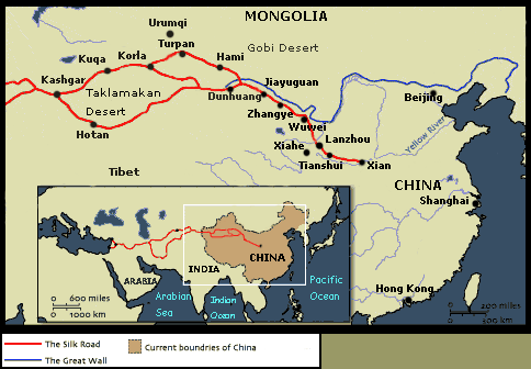
Baiyin, which translates in English language as silver, has lies in a strategic territory which has been a part of Han Chinese teritory since the 2nd century B.C. and possbly even earlier. In its earliest known history the region was recorded as border region of the State of Qin during and afte the so called "Waring States Period" in China. as early as the Han Dynasty the territory was known as a place where to find silver (Yin). Hence, its name of Bai -yin. s the adjacent map shows, even at this early time, a "road" connected from Lanzhou, northward via Baiyin towards the Ningxia Plain, making Baiyin a regional cross-roads in close connection with the developing "Silk Road" out of Chang'An.
While the original Silk Road trading pathways were reconnoitered by envoys of the Han Dynasty (206 BC - 221 AD) court in Chang'An (Xi'An), slowly opening an inter-cultural doorway and trading path into Central Asia to the west via Lanzhou, nothing much is known or
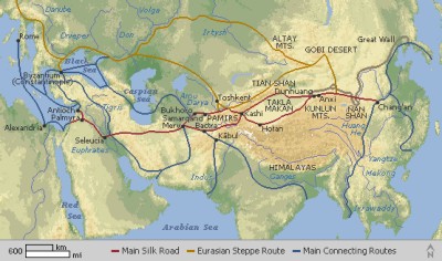
Map Trade Routes in Asia in the 13Th Century.
A Schematic Map of the Eurasian Trade Routes existing in the 13Th Century. Clearly marked in Red Accent on the Map are the cities of the network of land-bound trading routes through Central Asia known as the Silk Road (the path of Marco Polo and others).
Find DrBen and ChinaReport on Facebook with the latest from www.drben.net.
Baiyin has a semi-dry monsoon climate with plenty of sunshine and large temperature differences between day and night. Baiyin has better weather in summers and winters.
Annual sunshine time is 2,500-2,700 hours. January is the coldest month with average temperature of around 1.8-7.7 Degress Celsius. Summer average temperature is 19 - 22 Celsius. Frost-free period is 190 days per year. Annual average precipitation is 176 - 498 mm (Down from an earlier 185 to 500 mm) with most of the rain, some 60% of the whole, falling in July, August and September.
For general information, please refer to section: "Climate an Weather in Gansu Province", Part of our Introduction to Gansu Province.
No information available.
This page was last updated on: August 3, 2017
My Great Web page
Google supported Map of Baiyin and Baiyin Prefecture of Gansu Province of China (P.R.C.), by AsiaReport.com
Schematic Map of the various connected pathways of the ancient Silk Road, the main road of which led across the Yellow River at Lanzhou just south of Baiyin City .
In Baiyin City Prefecture the main ethnic group are the Han Chinese. Most of the inhabitants of Baiyin speak dialects of Northern Mandarin Chinese.
LANDMARKS OF BAIYIN PREFECTURE:
- The Yellow River.
If you have not seen it, take the time to drive from Baiyin City District to Pingchuan City District. About halfway along thisrout liesthe town of Jingchuan through which flows the water of the Yellow River. It is the easiest location within the Prefeture to meet up with the 3rd longest river in the world while seeing it in comfort.
- Yellow River Stone Forest & Park:
The one and most famous landmark of Baiyin Prefecture is reportedly the Yellow River Stone Forest National Park (景泰黄河石林景区) which supposedly is situated at about 40 kilometers (25 miles) North of Baiyin. The Yellow River Stone Forest Scenic Spot, formed by the rising of the earth's crust, is located in Longwan Village in Jingtai District of Baiyin Prefecture and composed of many colorful sand stalagmites and stone pillars in various sizes and grotesque shapes.
Although internet sources say that the Yellow River Stone Forest Park is famous for its natural stone
Map of the neighboring Lanzhou Prefecture marking the location of the most popular and renowned scenic sites and landmarks outside of that city.
the Yellow River (Huang He) which, apart from water, also provides most of the local landscape. The city of Baiyin is situated upon the very western extensions of the loess plateaux of the Yellow River basin and the mighty river cuts its path through this plateaux in a long and winding gorge. Altogether, the Yellow River flows from south to north for 214 kilometers through Baiyin Prefecture.
Although the Yellow River flows through the city of Lanzhou, the city of Baiyin has no direct access to the river and its waters. Instead it is positioned a few kilometers due north of the Yellow River. On its way from Lanzhou into neighboring Ningxia Hui Autonomous Region the Yellow River flows south of Baiyin through Baiyin Prefecture and through the town of Jingyuan.
TRAIN STATION OF BAIYIN AND TRAIN CONNECTIONS IN BAIYIN CITY:
Baiyin is a station of the Baotou-Lanzhou Railway as well as of the Baiyin-Baojishan Railway.
As the name suggests, the second main railway line in Baiyin connects south-eastward to the city of Baoji in Shaanxi Province, an ancient city and stop over point on the Silk Road out of Chang 'An (Xi'An). The Baiyin–Baoji line has a total length of 251 kilometers. In Baoji further lines connect through eastward to Xi'An, southward into Sichuan Province and to Chongqing and northward into the Mu Us desert of Yan'an and historic Yulin in Shaanxi Province.
In addition to the above mentioned main lines, Baiyi provides connection with the Gansu to Wuhan railway line.
LANZHOU ZHONGCUAN NATIONAL AIRPORT:
No information available.
ROAD CONNECTIONS IN BAIYIN AND PREFECTURE:
As mentioned Baiyin is by no means a tourist destination and there are few landmark worth seeing. The only real reason that Baiyin has grown to be a city is becaue of its important function as a cross-roads within the northern territories of south Gansu Province. Situated due north to north-east of the large industrial city and near its airport, Baiyin is also situated along the traditional and only road north-eastward into the neighboring Ningxia Hui Autonomous Region. With the traditional cart paths, caml trails and narrow provincial roads replaced by the multi-laned G6 Jinzhang / Danla Expressway Baiyin is now very well connected and has become an important transportation hub within Gansu Province.
The State Highway 312, the State Highway 309, the State Highway 109 run through the city. In addition, there is a 69 km expressway connect Baiyin and Lanzhou, capital city of Gansu Province.
SHIPPING AND PORT OF BAIYIN:
Reportedly a shipping construction project of the Huanghe (Yellow River) is underway with the aim of connecting the yellow river port of Silong to the Wufo port . Supposedly this involves a distance of 150 kilometers is being carried out step by step.
Although this suggests one might make a boat ride on the Yellow River or even ship onesself from Baiyin upstream or downstream along the Yellow River, in reality this is not the case. Various dams of the Yellow River make travel downstream to Baotou or upstream to Lanzhou impossible. No one travels by boat on the yellow river anymore.
Baiyin’s mining industry experienced its prime time by the Ming Dynasty (1368 AD - 1644 AD). It was during this time, now 600 years ago, that the town of Baiyin became a city famed for its Baiyin Factory, an official institution which handled the excavation of gold and silver, and the subsequent distribution of it under a Government run monopoly. Taking the official name "Good Silver", the city has been the only city named after noble metal in Chinese history ever since.
In the 1950's Baiyin was developed as a copper mining region leading to an erratic pattern of economic growth and downfall. The decades of mining and industrial activity have left a considerable pollution problem and environmental degredation which go under advertised in the city or region itself.
For general information on the history of Baiyin City and Prefecture, please refer to: "History of Gansu Province".
columns it is not on the main tourist itenerary, not even for tourist agencies operating out of the city of Lanzhou. Most China experts will never have heard of his park so you wil have to find your own way making use of our directions and available maps.
The Dunhuang Movie Set, which is situated on the half way from the Yellow River Stone Forest to the ancient city of Yongtai (Turtle city), is the first movie set in China carrying on the culture of Dunhuang.
Among the other scenic spots reported to be located in Baiyin and Prefecture are an assortment of historic sites relevant to different era's of China's long history. Among these are (new) stone age sites of the so called Ban Po culture, which existed even before China's feudal age started in the wide region of the Yellow River basin. Early Historic and Cultural Relics sites in Baiyin Prefecture are:
- Banshan (or Banpo) Cultural Relics
- Beichentan Castle Relics, a (new) stone age (neolithicum) relic site.
- Faquansi Cave
- Niumendong Cave, famous for its pottery finds.
- Yongtai "Turtle City".
Historic sites dating from China's lengthy feudal era are:
- Han dynasty tomb of the ancient city Diaogou.
- The Great Wall of Ming Dynasty.
- Baiyin Pinchuan Hongshan Temple Grottoes, these are found near Pingchuan Town of Pingchuan District in the south of Baiyin Prefecture. Travel distance to Baiyin unknown. Travel to Tongxin town of Tongxin County in neighboring Ningxia Hui is 55 miles traveling in a north eastern direction.
Schematic Map of the main pathway of the Silk Road, connecting the Han and Tang Dynasty Capital of Xi'an, via Lanzhou just to the south of Baiyin, to Central Asia.
Sites of famous natural beauties and wildlife in Baiyin and Prefecture are:
- Si’erwan grotto
- Tiemu Mountain
- Taohua Mountain
- Wulan(g) Mountain
- Quwu Mountain
- Shoulu Mountain
- Hasi Mountain
The specifics on all of these locations are still under research.
In addition Baiyin is also hailed as a memorial place, as historically the several (often competing) branches of Red Armies on the Long March joined Forces in this region in early 1936, on their final route to Yenan in Shaanxi Province where they joined the existing Shaanxi Soviet.
The local food speciality in Baiyin is Darou Noodles and mutton.