Traditional local products for which Wuzhong is known are: Pearl Rice, Apples, Melon Seeds, tanned sheep skin and leather and Yellow River carp.
Since the year 1964 the City of Wuzhong is home to a polluting aluminum smeltery. Today known as the China Power Investment Ningxia Qingtongxia Energy and Aluminum Co., Ltd it was formed from the earlier Qingtongxia Aluminium Factory of 1964 AD and the China Power Investment Group which sprang forth from the building of the Xingtong Gorge Dam (Xingtongxia: 青铜峡). It is a state-owned enterprise with a registered capital of 5 billion yuan. It is mainly involved in the aluminium, power, coal and coal chemical industries.
In 2007, the total sales revenue and profits of the company reached 6.976 billion yuan and 354 million yuan, respectively. It produced 414,700 tons of aluminium and aluminium products.
Local Topography of Wuzhong :
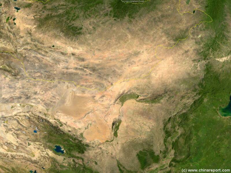
As can be seen on below satellite image, the Loess Plateau of Gansu Province and South Shaanxi Province intersects with the sands of the Gobi Desert in the West and with the Ordos desert (the so called Ordos Massif) in the West. In the middle of these sits Ningxia consisting of the alluvial plain of the Yellow River (Huang He:黃河) and a mountainous area, the Helan Shan, at some distance west of the River.
Today dammed at Xingtongxia (青铜峡), in the western suburb of Wuzhong City Prefecture, the yellow river provides Wuzhong with the relatively new geographical feature of the Xingtongxia Reservoir, which can be found nearby extending way south up the river to Zhongwei and Shapotou.
A major irrigation canal branches off the river near the hydro-electric dam and runs north, providing the main irrigation artery for the Wuzhong Region.
The terrain of Wuzhong generally declines south- north. Its northern area belongs to the Yinchuan Plain, while the south has a distribution of hills and mountains.
Ethnic Minorities in Wuzhong & Prefecture
Wuzhong & City Today :
History of Wuzhong:
Wuzhong Climate & Weather :
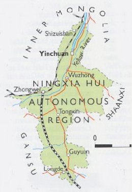
Wuzhong (吴忠) Basic Knowledge :
This page was last updated on: July 19, 2017
The Wuzhong Report
Introduction to Wuzhong (吴忠)
Wuzhong Landmarks & Monuments
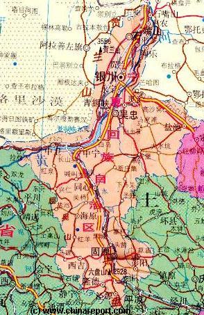
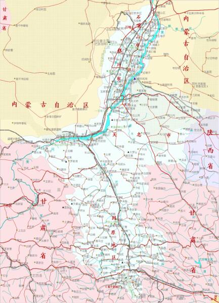
Wuzhong City & Area Maps
Location : 37° 59' 31" North, 106° 12' 9" East
Elevation : No Information available.
Surface Area:
Urban - Total Surface area of the City Prefecture of Wuzhong 27,000 square kilometers (10,425 square miles).
Population: The Total Population of Wuzhong City is and Prefecture is about 2 million souls.
The population of Wuzhong was an estimated 600.000 in the year 2003, 350 thousand in the Litong District and 250 thousand in the Xingtongxia (Bronze Gorge) District. Currently however Wuzhong counts over 2 million inhabitants, of whom some 720.000 are part of the Hui Ethnic Minority.
Wuzhong is situated roughly in the center of Ningxia Hui Autonomous Region, just 60 kilometers south of the regional capital of Yinchuan along the yellow river. Most of the city is built on the eastern banks of the river.
The Wuzhong Report is part of the overall website www.ChinaReport.com & www.drben.net
Learn about what is new on this Site from below window.
ChinaReport.comat
The main landmark of todays Wuzhong City is the Bronze Gorge (Qingtongxia Dam). The Qingtongxia Dam on the Yellow River (Coordinates: 37° 53′ 05″ North 105° 59′ 25″ East / 37.88472°N 105.99028°E / 37.88472; 105.99028) is located in the west of Wuzhong City and is part of the Qingtongxia District, so excursions to the Lake are easy to organize. For those who have abundant time to spend it is possible to explore the entire lake by Boat, to see the hydo-electric Dam of the Bronze Gorge, as well as landmarks upstream such as the 108 Tibetan styled Dagoba′s or Yibailingba Ta of Xingtongxia Zhen (village). The Dagoba′s are situated along the banks of the reservoir lake, some 15 minutes upstream (south) of the Dam.
A major irrigation canal branches off the river near the dam and runs north, providing the main irrigation artery for the Wuzhong Region.
Traditionally the second landmark and the most visited tourist site of Qingtongxia and Wuzhong City are the 108 Dagoba′s of Yibailingba Ta.
Arranged in a triangular pattern against a hillside overlooking the Bronze Gorge stand no less than 108 Stupa′s or Dagoba′s of the Tibetan style. As yet undated in their origins, the 12 rows of white vase-like structures are thought to have been constructed on this site during the reign of the mongol Yuan Dynasty (1271 AD - 1368 AD). Largely smashed and ruined during the years 1966 AD - 1967 AD of the Cultural Revolution Era (See: ′History of Ningxia Autonomous Region (1 through 5)′), the renovated stupa′s proudly stand at attention today, reminding of bygone times when all of Ningxia was a Buddhist land.
Public Transport in Wuzhong
The Main and only Railway Station of Wuzhong City - no information available.
Click Below Link for an up to Date Train schedule for Qingtongxia Station - Wuzhong City.
Wuzhong has a Railroad Station named Qingtongxia. It is located in the western parts of Wuzhong City.
The earliest human remains and objects found in the region of Wuzhong (currently) date as far back as the end of the stone age. In those days small wandering tribes of nomads criss crossed the region, naturally prefering the available waters of the Yellow River and the abundant green and wildlife as a good spot to stay on for longer periods.
Wuzhong City Prefecture is divided into four administrative units, there are two urban districts and two rural counties. The City Districts are Litong District (利通区) and Xintongxia District (青铜峡市). The rural counties are Yanchi County (同心县) and Tongxin County (同心县).
The central down-town district of Wuzhong City is the Litong District which basicly includes the old town of Wuzhong. Wuzhong is not a real city but a composed administrative unit, meaning that it is based on what originally was the Town of Litong plus a collection of small surrounding villages.
Today, much of this situation remains. The inner city is a solidly built up urban section, but the further away from the downtown area, the more the scenery starts to resemble the rural country-side.
The entire western side of the city is taken up by the Xintongxia District, which includes the flow of the Yellow River past Wuzhong, large spaces in use for agriculture intermixed with freshly constructed swaths of large modern villa's or small pockets of fully modern housing. It is a bit of an odd mix out here on the edge of the desert.
Administratively, Qingtongxia is a county-level city within the prefecture-level city of Wuzhong. It is located on the left (northwestern) bank of the Yellow River, opposite and a bit upstream of Wuzhong main urban area.
Qingtongxia has more than 100.000 residents. Many residents of Qingtongxia are Hui Muslims.
Due East of Wuzhong City, lies the town of Lingwu, which is becoming a suburb of Wuzhong.
Noted Chinese Citizens from Wuzhong City in Ningxia are: Zhou Shengxian, the director of the State Forestry Administration, is from Wuzhong, Zhou Shengxian, the director of the State Forestry Administration, is from Wuzhong.
There is no information available on Hotels and Hostels within Wuzhong Prefecture.
Please make use of adjacent banners to find more information,
or return at a later Time.
Situated favorably in Ningxia Region, one of the regions with the most abundant sunshine in the entire Peoples Republic of China, Wuzhong is a good getaway destination nearly all year around.
Although winters can be bitter cold with quite some snowfall, between may and october weather is usually fair and sunny, with crystal blue skies and very sparse precipitation. Regardless, Wuzhong is green nearly throughout
the year due to the abundant irrigation available from the nearby yellow river.
Due to the mix of surrounding deserts and the vicinity of the river and irrigated lands Summers are hot but not too dry nor to humid in Wuzhong. Dust storms may arise, which occurs generally between March and May. In that case: stay indoors or be sure to come prepared.
Satellite Image Map of the Entire Gobi Desert Region. Map overviews North-Eastern Qinghai Province, Gansu Province, Mongolia, Inner Mongolia Autonomous Region and North and North-Eastern China giving a Full Overview of the Gobi Deserts and a large part of the flow and path of the yellow river.
As described in the 'History of Ningxia Hui Autonomous Region (1 through 5)', the Ningxia Region was first reached and settled by Han Chinese during the Qin Dynasty Era (221 BC - 206 BC) although it was not until the Han Dynasty (206 BC - 221 AD) rule period that the new position could be solidified. At the time the region of what is today Wuzhong City was included in the irrigation projects of the day. Thus, Wuzhong was a settled and sparsely inhabited region by the second century BC. There were only a few farms and but a few villages though.
By the Time of the Tang Dynasty Era (618 AD - 907 AD) the entire Ningxia Region had been included into the Han Dynastic Realm and was supported by a military garrison. In the region of Wuzhong horses were bred for the imperial armies. Agriculture flourished throughout the regions, as did the faith of
Buddhism, which saw a large nationwide upswing during the second half of the Tang Rule.
Wuzhong or parts of it go unmentioned in the long lost history of the Tangut Dynasty (also known as the Xixia, western Xia Kingdom) which reigned from 1038 AD to 1227 AD, although by that time the Wuzhong Region had long been lost to the military campaigns of the rising Mongol Tribes to the North and North-East which united under Genghis Khan (1162 AD – 1227 AD).
Muslim influences and later full islamic culture came to Wuzhong during the years of the Yuan Dynasty (1271 AD - 1368 AD) and remains to this day.
During the early and mid-19th century, the territory of today's Wuzhong - as well as much of northern Ningxia - became a stronghold of the Jahriyya Sufi order (menhuan), which was headquartered in the town of Jinjipu (located a few km south of today's Wuzhong's main urban area). Under the leadership of the order's fourth and fifth shaykhs, Ma Yide (the 1770s - 1849 AD) and Ma Hualong (deceased 1871 AD), it grew wealthy from the profits of caravan trade across Inner Mongolia, between Baotou, Hohhot and Beijing, and Jinjipu became an important commercial and religious center. During the Muslim Rebellion of 1862 AD -1877 AD, Jinjipu became the headquarter of the rebels in the Ningxia region. The town fell to Zuo Zongtang's troops in January 1871 AD, and over a thousand rebels and residents were massacred; Ma Hualong with his family and Jahriyya officials were executed in March 1871 AD.
You Tube Video: The Bronze Gorge Reservoir, Hydro-electric Dam and 10 Stupa′s, Wuzhong City.
A Full listing of Wuzhong City Landmarks, Monuments, Hotspots and other sites of importance in alphabetical order. Search through the list to find your Full Report and Photo-Virtual Tour of each monument or landmark within the City, or Region of Wuzhong in Ningxia Hui AR of China (PRC).
Recently, many changes have been taking place in the otherwise remote and rural Town of Wuzhong. In addition to an overt increase in (heavy) industrial activity, a building and development boom seems to be gripping the entire length of the Yellow River in Ningxia swallowing up even large desert area′s.
Furthermore, in recent years a seeming boom in the tourism industry is als underway further transforming the landscape but also changing the previously rural and layed back lifestyles of the locality. As a witness to it all one may see the concrete highrises under construction in the Litong District (=City of Wuzhong), as well as on the west bank of the Yellow River. While rural villages are modernized, enormous industrial complexes appear everywhere along the river, and meanwhile the most attractive scenic spots along the river have drawn the interests of the tourism industry and its investors.
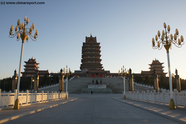
Among things this has led to the appearance of a tourism zone on the west bank of the river across from the Litong district. It is in this zone that one of the spectacular tourist attractions of the Ningxia Hui Autonomous Region has recently been completed. The new attraction is nothing less than a whapping 8 story pagoda, accompanied by two substantial flanking pavilions, the whole built on a Temple Mound created on a (seemingly) artifical island. Since about
In July of 2010 the Qintongxia (City) District of Wuzhong City Prefecture became the stage of the Pakistan-China YOUYI-III (Friendship) Joint Military Drills. The exercises were intent to increase cooperation in anti-terrorism skills and education of Chinese Military in such practices.
In the words of the Commander of China's Lanzhou Military Area Command under who's authority the Ningxia Region falls, the joint military exercise between Pakistan and China "is of profound and far-reaching importance in consolidating the friendship between the two countries and armies, upgrading their capabilities in fighting terrorism together and safeguarding regional peace and stability". Commander Wang Guosheng made these remarks at the opening ceremony of the China and Pakistan joint anti-terrorism drill that started in Qingtongxia in northwest China's Ningxia Hui Autonomous Region on Saturday, July 1st of 2010.
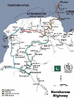
Apart from maintaining good relations with a vital strategic neighboring nation, China's interest in the exercises are first and foremost the stabilizing and pacifying the Western regions, mainly in Xinjiang-Uighur Autonomous Region, but alo such restive regions as Tibet. China's western-most city, the City of Kashgar, is directly connected to the Pakistani Capital of Islamabad through the Karakoram Highway, at the moment the highest road in the world. Due West of Kashgar the ongoing conflict in Afghanistan adds further fuel and weapons to be used by terrorist and recently large ethnic clashes in Kyrgyzstan have further emphasized the specific military needs for the region.
The drill, code-named "Friendship-2010," was the third of its kind between the two countries. More than 200 people, including soldier participants and military spectators, attended the opening ceremony of the drill. Commander Wang said the drill would also help promoting military understanding and mutual trust, enhancing military exchanges
and cooperation between the two sides. Lieutenant General Khalid Shameem Wynne, Chief of the General Staff of the Pakistan Army, speaking on the occasion
You Tube Video: The YOUYI-III Joint Chinese-Pakistani Anti-terror exercises in Qingtongxia, Wuzhong City, Ningxia Hui AR in 2010.
Asia Report - Map of Karakoram Highway / China-Pakistan Mountain Highway
said Pakistan and China had all-weather friendship, which could transcend borders and have enjoyed popular support. He said the drill showed the two countries' determination to combat the "three forces"—referring to extremism, separatism and terrorism.
China and Pakistan held their first-ever joint anti-terrorism exercise, "Friendship-2004," in Xinjiang's Taxkorgan Tajik Autonomous County (Kashgar Prefecture) which is situated along the strategic Karakoram Highway and borders on restive Tajikistan, conflict ridden Afghanistan and the unstabile nation of Pakistan. About 200 border soldiers from both sides participated. The second joint anti-terror military drill, "Friendship-2006," was carried out in the hills of northern Pakistan's Abbottabad. More than 400 soldiers from the both armies took part. [Source: CCTV News Channel]
For more information on the History of Wuzhong from Pre'- History to Present, please refer to:
Wuzhong is connected to Yinchuan via China National Highway 211.
Another large industry in the City is of an entirely different nature. This is the Xiangyun Fur Co. Ltd.which was established in 1984.
Due to its good access and abundance of good quality Mongolian Fur(s), the Xianyang company was able to develop very rapidly and now does business on a large scale nationally and even internationally. Among things it has the most advanced equipment as well as the largest scale in local area ,tanning and dyeing, producing and trading within China entire.
Xianyang Fur Company in Qingtongxia District process around 130 thousand Mongolian Furs of high quality in a year. It maintains high quality, producing clothing and adornment, but also a wide variety of household articles and other products such as scarves, collars, cuffs, handbags,shawls, clothes, hats, cushions ect in Tibet-lamb fur, fox fur, mink fur, and rabbit fur. Products are exported widely to Europe, the United Kingdom, USA and Japan as well as in China.
In 2002 Xianyang expanded, building a new factory in Tongxiang of Zhejiang Province in 2002.
There is no maps of Wuzhong ity Prefecture and Qingtongxia.
For all Maps relevant to Ningxia Hui Autonomous egion of the past and present, please refer to:
The nearly abandoned Gargantuan 8 story pagoda and two flanking pavilions of the ″Temple of the Mother Goddess of the Yellow River″ near sun down on a quiet afternoon in November of 2013.
the fall of the year 2013, the stunning and elaborate complex serves as the so called ″Temple of the Mother Goddess of the Yellow River″. Since this is not in any way a recognized Religious denomination within the Peoples Republic of China it all comes a bit as a surpise. Various dieties and apparent sages depicted in bronze seem unfamiliar and thus, although impressive, stunning and esthetically complete, visitors come away with a rather grotesque experience.
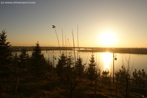
The only barrier between city and Temple is the Yellow River itself which at this point is more than a kilometer wide, even in the dry low water seasons. Notably, it has not 1 but two channels both of which must be crossed .The safest mode of transport across is to arrange for a local taxi to drive you safely across the mighty river without the danger of any unfortunate but all to frequent road accidents.
Alternative modes of transport to the Mother Goddess Statue and Temple are imaginable. One could take a local bus with all due delay, or one could arrange for a bicycle to bridge the river and the distance to the Temple. A bicycle also allows for easy exploration of the new tourist village and sites along the river. Please do mind the local traffic !!
Crossing the Yellow River bridge at Qingtongxia by foot seems ill advised
due to the abundant heavy transports crossing the bridge and the large distances involved.
Other local Wuzhong tourist attractions are less well-known, especially to Foreign visitors. These are the NiuShou Shan with its Temples, and the so called Qingtongxia Tourist Zone a rare place where, in summer, one can raft on the yellow river on authentic inflated pig skin and bamboo rafts.
View of the Yellow River and the Wuzhong/Qingtongxia road bridge around sundown in November of 2013. The nearly frozen waters of the river flow calmly by at this point and this time of the year.
China Report - Map of the Great Wall during the Ming Dynasty
Satellite image of China and North-East Asia, with a super-imposed schematic Map of the location and Path of the Great Wall as constructed during the Reign of the Ming Dynasty. Included for reference are City names, geographical features of landscape, Names and locations of Passes on the Great Wall of China.
The city of Wuzhong lies almost centrally within the Ningxia Hui Autonomous Region which makes it a good jumping off point for reaching other interesting locations and destinations within the Ningxia Region and Wuzhong Prefecture.
First and foremost, only some 80 to 100 kilometers to the north lies the Capital of Ningxia Region, Yinchuan City, with an interesting old town district and various cultural and historic treasures, not to mention Yinchuan Airport, in the vicinity.
A second destination of interest to be reached is the City of Zhongwei, which can be found at a distance of around 80 to a 100 kilometers almost due west from Wuzhong. Situated upstream of Wuzhong near an interesting Bend of the Yellow River, the city of Zhongwei is a fast developing but mostly still rural town which apart from its unique Mao Zedong Statue and magnificent Buddhist Monastery is home to a few interesting segments of the Great Wall of China. Although heavily eroded, severly threaten by local industrial development and in most places nearly forgotten, the Great Wall between the town of Zhongwei and the Tengger Desert is of great historic interest as parts of it were first built in the year 2200 BC during the Qin Dynasty (221 BC - 206 BC).
Finally, from Wuzhong one can easily make ones way down southward in order to visit the County Town of Tongxin (Wuzhong Prefecture), the location of the only original Mosque in Ningxia to survive the Cultural Revolution Era (1966 AD - 1976 AD) and the City of Guyuan and regions beyond.
For information on the Landmarks, Monuments and Scenic Sites of the wider Region of Wuzhong City, Yinchuan and beyond, please refer to:
Map - Schematic - Hebei-Beijing-Tianjin Great Wall Locations
A Schematic Map overview of Great Wall locations and sections in Shanxi Province, Hebei Province, Beijing City Province, Tianjin City Province and parts of Liaoning Province. This Schematic Map focusses on the seperate visitable Great Wall of China locations and sections within the depicted regions, and includes as the Main Monuments and Scenic Sites in their vicinity as well. Find the locations of the Great Wall of China in northern Shanxi, the famous fortified "Heaven's Gate" (Kalgan) Fortress in northern Hebei Province, the "First Gate under Heaven in the East and the Terminus of the Inner Layer in the East (Laolongtou) and several often overlooked sites in Liaoning Province.
In addition, those willing to explore and go through some effort to see all of the surroundings may have a ball exploring the desert-like rural lands to the West, South, East and North-East of Wuzhong heading out in search of more remains of the illustrious Great Wall of China. Several parts of the Great Wall lie mostly forgotten and unvisited by tourist groups in the vicinity which however does not mean that they are easily located.
To start of with the easiest Great Wall of China parts to be reached from Wuzhong City, these are without a shadow of a doubt the segments that stand beyond the west bank of the Yellow River, which in Wuzhong runs almost north to south between the Desert of Inner Mongolia and the green strip provided by the fertile River and modern irrigation sytems. The Great Wall to the west of Wuzhong is most easily identified as the southern extensions of what essentially is the Sanguankou (Three Gates Pass) Great Wall of China. The Sanguankou is the Great Wall Pass which lies due south west of Yinchuan City, but even today the mud wall still extends some 80 to 90 kilometers southward from there to reach as far south as the town of Qingtongxia. Historically it ran straight south along the river and connected all the way through to Zhongwei.
Other relatively easy to find and identify parts of the Great Wall of China are found due south of the current day City of Wuzhong where a variety of remains of an Inner Section of the Great Wall of China can be identified. Locate these along both provincial road S101 (southbound to Hongsibu Town in Tongxin County) and the G211 National Road / S3 Yinxi Expressway which lies further to the East and leads down to the village of Hui'Anbu (also: Hui'Anpu) (in Hongsibu Township, Tongxin County, Wuzhong Prefecture) and the Qingyang Prefecture of neighboring Gansu Province. Ruins of the Great Wall of China can be found in a scattered line running some ways north of the intersection of G3 Yinxi Expressway and east-to-west the G2012 Dingwu Expressway. (Please refer to our Great Wall of China Google Map for location details and GPS Coordinates of each part).
As can be glanced from the available Map materials, there are two seperate groupings to explore.
The first grouping of ruins of the Great Wall of China south of
Wuzhong City can be found in the Liujia Kiln (Village) area just north of Hongsibu Town. This is a location roughly between the north edge of town and G2012 Expressway and the curving of the S101 Provincial Road to the west (the location where G70 Expressway splits from G6 Expressway, the latter leading down from Wuzhong to Hongsibu Town and still under construction( in 2014)). The village of Liujia Kiln has a history closely associated with the presence of the Inner Layers of the Great Wall of China in this southern region of the Ningxia Plain and the Great Wall itself dates back to well before the Ming Dynasty Era.
The second grouping of ruined Great Wall of China segments due south of Wuzhong City is found near the adjacent village of Hui'Anbu, which administratively resorts under the Hongsibu Township. Lying at an elevation of around 1,349 meters above sea level in the bone dry and dusty hills of the loess plateaux, the town of Hui'Anbu itself is of little or no interest except as a way station along the way. Beyond, more to the north however one can again find the line of the Great Wall of China the ruins of which run from west to east, when followed heading for the mountains and leaping across them into the mostly empty and arid southern extenses of Dingbian County of Yulin Prefecture in adjacent Shaanxi Province.
------>> For more information on these sections of the Great Wall of China see also: ″Tongxin County″ and ″Yanchi County″ (Wuzhong Prefecture).
Although the County Town of Yanchi and the Yanchi County Great Wall of China are also administratively a part of the Wuzhong Prefecture, in reality the distance between Wuzhong City and Yanchi is far to great to reach from Wuzhong City and have any effective time left to explore the Great Wall in the area. Those interested in visiting and exploring the Yanchi County Great Wall of China of Wuzhong Prefecture are advised to book accomodations in Yinchuan City and reach westward from there. Travel time between Yinchuan and Yanchi still is some two to 2 and a half hours minimum, but overnight stays in Yanchi Town are possible eversince the recent opening of a railroad station in town. As an alternative, one might travel from Yinchuan Station to Yanchi by train, and from there move on to Yulin in Shaanxi Province or another remote rural destination.
Hui'Anbu
Hongsibu
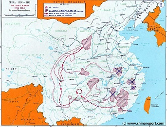
China Historic Map - Route Long March 1934/35 - 1A
A Schematic overview Map of the current Peoples Republic of China depicting the main route(s) of the epic Long March of 1934 and 1935.
Map clearly delineates PRC China current National borders and includes Provinces and Autonomous Regions, Main Cities and relevant Towns, initial Communist Soviets (Self-administered rebel areas), the routes followed by various elements among the Communist Groups and Armies, locations of important meetings points, main natural obstacles such as mountain ranges, the flow of large rivers such as the Yangtze River and Yellow River, position of the Great Wall of China in Gansu Province, Ningxia Hui Autonomous Region, North Shaanxi Province etc, rough estimated routes of main railroads of the time and other details of interest.
Mouse over locations and link through for additional information on each location.