The Path of the Yellow River through the China (2) Middle Reaches: Gansu Province (3c) Baiyin (Good Silver) Prefecture
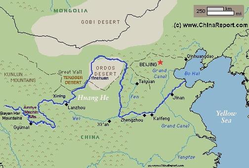
The Yellow River is China's second longest river, measuring some 5464 kilometers (3,395 miles) in length. It is the world's 6th longest river.
The Yellow River is known in Chinese as Huang He and also as Huang Ho depending on spelling.
The drainage basin of the Yellow River, known as the Yellow River basin, is the third largest of all rivers in China (P.R.C.), encompassing a surface area of around 750,000 square kilometers (290,000 square miles)(official: 742,443 km² (290,520 mi²).
It extends 1900 kilometers (1.180 miles) from West to East and 1100 km (684 miles) from South to North.
The China Report
Introduction to the Yellow River (Huang He - 黃河) - China's 2nd largest River
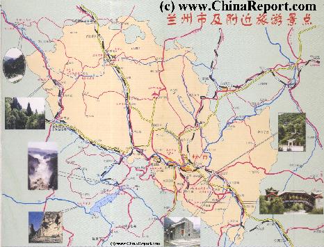
A rough Geographic overview Map of Lanzhou City and City Prefecture of South Gansu Province. Map depicts Lanzhou's five city districts stretched along the Yellow River Banks, four outlying counties.
Sites and locations included are main highways and roads, Lanzhou Zhongcuan Airport, main railway lines, main mountains and heights, rivers and Lakes as well as main monuments & landmarks of the City & Area and main ethnic minority population centers such as Tianzhu Tibetan Autonomous Township, Minhe Hui Autonomous Township.
Locations of the Great Wall of China in the Vicinity are included with Links to Reports with more Photos and background information on each site.
orinally known as a silver mining district (Hence its name: BaiYin = Good Silver) it is today also historically famous as the place of joining of two main army groups of the the Communist Army as it neared the end of the "Long March" in October 1936. In addition, although today not much advertized additional ruined sections of the Great Wall of China of the Ming Dynasty Era (1368 AD - 1644 AD), once renowned from the tales of the Long Marchers who moved along it in its shadow, can be found along the Yellow River in the Baiyin Prefecture (see Map above on Page).
Apart from the silver traditionally found in Baiyin, there is an abundance of other minerals found throughout the prefecture. Among them copper, lead, zinc, gold, silver, antimony, tungsten, tin, molybdenum and others. In addition the region is rich in limestone and coal. As may be expected, during the economic boom over the last 30 years, Baiyin has become one of the many national centers of the mining industry, with these industries contributing to the pollution of the waters of the Yellow River. Adding considerably to the pollution already absorbed on its pass through the city of Lanzhou, in this region the mining industry and other industries are notorious for dumping their raw waste and sewage directly into the river and Greenpeace China marks this stretch as among the most worrying along all the Yellow River. As Robbert Gifford described it in his article for NPR Television in the year 2007: "Two hours downstream from Lanzhou, in the blur of smelters and factories of the industrial city of Baiyin, a dark, fetid outflow that barely passes for water is draining into a stream. The stream flows into a small tributary that then flows directly into the Yellow River.
Here, suspended in the filthy water amid the sounds and smells of the industrial revolution, are some of the biggest questions facing modern China: Can the country maintain double-digit economic growth without destroying the natural environment? And is the blowback from industrialization starting to negate the very real economic progress? ".
Baiyin Prefecture of Gansu Province is an area which lies on the loess plateaux and which traditionally was an arid and dusty region thin in population. No
Yellow River Hoodoo Geological Park:
Just on the other side of the border within Ningxia Hui Autonomous Region the first name marked on the Google Map is Xiaweizikeng, however by all means, if there was a village there once it is now gone.
Thus, the first live village found along the Yellow River is Beichangtan.
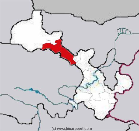
BAIYIN PREFECTURE OF GANSU PROVINCE:
Beyond Lanzhou, the yellow river enters a region of the Loess Plateaux that sees very few Foreign travelers and has no tourism industry to speak of. This is the Baiyin Prefecture of Gansu Province
Zhuli River:
The Yellow River Hoodoo Geological Park consist of a totally arid section of the loess plateaux, which lies just south of the sandy Tengger (Tengeli) Desert. Due to its lack of rainfall and high altitude compared to the river in the gorges below it is mostly inhabited. Although the Map shows the names of villages perched along the river banks in this section, in reality these are but name places on the Map. Anyone who lived there has moved since. Smaller villages consisting of but a few houses and families have been abandoned and mostly raised, their inhabitants moving along the newly built roads to Jingyuan or some other nearby town or city.
Today there is but one village alive along the last curve of the river. This is the village of Wufoxiang, which can be found where S308 Provincial Road has its bridge across the Yellow River.
At Wufoxiang the yellow river makes has a another bend turning in a due north easterly direction, then
agriculture was possible and all life depended on the Yellow River.
This old saying still holds true, however a few years ago a new project was launched in an attempt to develop the higher parts of the Loess Plateaux for agriculture. Along the trajectory of the Yellow River through Baiyin Prefecture water is siphoned from the river, in case of the Baiyin Prefecture, being lifted - pumped up to the plateaux where it has since given life to a successful and much praised agricultural industry which the prefecture claims to be unique in. This could well be true for a number of reasons.
Altogether, 12 such "high-lift irrigating agriculture" projects have been developed so far and can be found along the river at Jindian, Jinghui and Xingdian villages.
City of Baiyin:
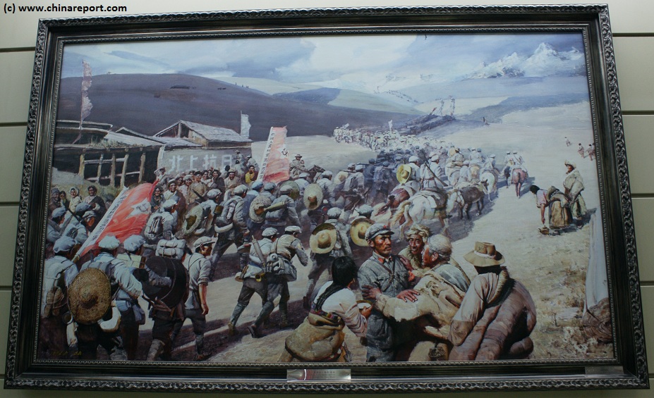
Artist rendition of the Long Marchers nearing Huining in Gansu Province, as seen in the Military Museum of the Chinese Revolution in the Haidian District of Beijing - CLICK IMAGE TO ENLARGE -.
As Sun Shuyun has an old lady who participated recall the moments in her book: "We rushed to greet eachother, throwing our packs and rifles to the ground We laughed, jumped up an down; we burst into dance, i was ecstatic. I grabbed a soldier from the 1st army and started crying. We surged towards (the county town of) Huining like a flood breaking through a dam." The Communist Armies had been reunited and where reaching the north west where a front line with the Japanese Invaders was vaguely established. That was on October the 10th of 1936 and ever since Huining has been celebrated in posters, flags and paintings commemorating the great heroism of the Long March and its sacrifices. Officially, the day is also counted as the end of the Long March and the beginning of the establishment of Mao Zedong's base area in Shaanxi Province.
As General Zhu De, the Commander in Chief of the Red Armies put it at the time during his speech in Huining where he read out the following telegram from the Central Committee of the Chinese Communist Party and their Military Council: "The Union of the Three Red Armies and their entry into the anti-Japanese front line will be crucial ... We will fight to safeguard nort-West China, North China and all of China". Those were great words that have been recounted, although it may be noted that at the time few inside the Communist Party Leadership had any idea of how to actually achieve this. But, first the few remaining Long Marchers, their numbers dwindled by starvation, illness and
desertion had to follow the Great Wall and the Yellow River north-eastward to end up at their eventual Base, at the time already established as the Shaanxi Soviet. While the main armies re-united in Huining in Gansu Province, Mao had already reached Shaanxi Province and was awaiting there.
READ MORE ON THE SHAANXI SOVIET IN: "HISTORY OF SHAANXI PROVINCE" AND "HISTORY OF YAN'AN".
The City of Baiyin itself is one of those cities in China that have seen enormous development in construction. Until recently but a dusty and very marginal county town its has been newly modernized with the intention to draw in crowds of new inhabitants from the surrounding arid countryside. Although situated not too far from the city of Lanzhou and connected by a smooth and wide modern highway, it nevertheless remains an unpopular place to live. The few foreign travelers passing through the city report a "ghost town" of near empty resedential flats and little traffic on the streets in which life is but very slowly picking up pace.
For anyone traveling through this remote region, the Yellow River can most easily be viewed in the town of Jingyuan in Jingyuan County just south of Pingchuan City District of Baiyin Prefecture. The waters of the Yellow River flow directly through this town and thus, it is the easiest location within the Prefecture to meet up with the 3rd longest river in the world. To add to the scenery, this is also the location where a modestly sized tributary, the Zhuli River, joins with the mother river.
Among the few monuments and tourist attractions of Baiyin Prefecture along the Yellow River are several caves, a location of interest to archeologists known as the Banshan Cultural Relic site (of the Majiayao period) dating to the new stone age (neolithicum) and the monument (and educational base) commemorating the joining of the Forces of the Red Army in Huining County (会宁县). The Huining Point officially marks the end point of the Long March, eventhough the later rebel bases would be found more to the north and east in Bao'An and Yan'An of north Shaanxi Province.
As can be learned from the map above on this page, as well as the Cold War Era classic and propaganda piece "The Long March" by Dick Wilson and the more recent book "The Long March" by Sun Shuyun, this remote towns of the dusty Huining County along the Yellow River have been immortalized in the Revolutionary History of China. No huge battle took place in Huining County but instead it was there that the Long Marchers found a rejoiceful moment when all armies, and their leadership reunited after a long period of seperation (and mutual political strife).
READ MORE IN: "Landmarks and Monuments of Baiyin Prefecture" and "History of Baiyin Prefecture".
Notably, not too far from the border between Lanzhou Prefecture and Baiyin Prefecture the small Zhuli River flows from the Hills. The Zhuli River is one of the few regional tributaries of the Yellow River, flowing from the south south east through the Jingyuan County of Baiyin Prefecture to add itself to Yellow River after passing just south of the County Town of Jingyuan itself.
Beyond Jingyuan and Pingchuan, the Yellow River starts its last dramatic turn northward, arcing in a slow and long left curve to the border with Ningxia "Province" near Zhongwei of Ningxia Hui Autonomous Region. Before it reaches there, it passes through the so called Yellow River Hoodoo Geological Park.
Datong
Zhongwei
Schematic Map of the Flow Path of the Yellow River through China.