A Quick Navigation Menu giving an overview of each Great Wall of China section and location divided by Region and Province. From East to West.
Maps Great Wall China - Hebei Province
Maps Great Wall China - Tianjin City Province
Maps Great Wall China - Shaanxi Province
Maps Great Wall China - Shanxi Province
Maps Great Wall China - Gansu Province
Maps Great Wall China - Ningxia Hui Autonomous Province
This Maps Menu gives direct acces to all Great Wall of China Maps used in the China Report Web-site, as well as various maps directly relevant to the Great Wall of China and its pathway through northern China.
To Find even more Maps (Historic, Ethno-Linguistic, Satellite Image, etc) and supporting information please refer to China Maps - Index at ChinaReport.com
Introduction to Great Wall of China Maps Menu
General Maps o/t Great Wall of China
Very General Main Overview Map of Beijing City Entire , All City Districts, All Areas within the 6Th ring road, Very General Map of Beijing City Center , Very Accurate Detailed Map of same area Beijing City Center within Beijing's Third Ring Road.
( There are 6 ring roads)
Gives access to digital photographic tours of main sites within area of Map.
Beijing City Province Area Overview Maps
All maps of Beijing Municipality , Area's and Excursions outside Beijing City.
Map of the Northern Half of Beijing Municipality
( Beijing is an autonomous City Province ) including the Summer Palace, Jundu Mountains and The Badaling Great Wall of China, Mutianyu Great Wall of China and more details. Same Map of the Northern Half of Beijing Municipality
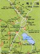
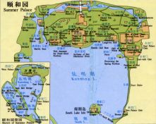
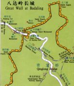
Juyung Pass 20 kilometers away. Site Map of Badaling Great Wall location, some 58 Km outside Beijing proper. Car Parking, Train Station, Area and All Walkable Wall Sections included. 13 Ming Tombs Site Map, a map of a Shisan Ling - 13 Ming Tombs Valley with all Tombs & Museums as well as ChangPing Village and Trainstation included. Summer Palace Museum Park Complete Site Map, all Pavilions and Sites at YiheYuan and around Kunming Lake in
overview of Beijing Municipality (Hebei) and Area to the West and South-West. Includes Datong and Pass to Inner Mongolia (Great Wall), BaoDing ShiJiaZhuang and TaiYuan Crossroads-cities. Wutai Shan and Yuntong Shan Mountain Ranges. Beijing Regional Map : Beijing-TangShan-TianJin-ShiJiaZhuang quadrangle, overview of Beijing City Province (Hebei) and Area to the East and South-East. Includes TangShan, City of Tianjin, BoHai Sea, GaoZhou, ShiJiaZhuang Crossroads City
Webstyle produced NavBar
Webstyle produced NavBar
Webstyle produced NavBar
Summer Palace YiHe Yuan Map
Badaling Site Map
Ming Tombs Map
ChinaReport.comat
All maps of Beijing Municipality , Area's and Excursions outside Beijing City.
overview of Beijing Municipality (Hebei) and Area to the West and South-West. Includes Datong and Pass to Inner Mongolia (Great Wall), BaoDing ShiJiaZhuang and TaiYuan Crossroads-cities. Wutai Shan and Yuntong Shan Mountain Ranges. Beijing Regional Map : Beijing-TangShan-TianJin-ShiJiaZhuang quadrangle, overview of Beijing City Province (Hebei) and Area to the East and South-East. Includes TangShan, City of Tianjin, BoHai Sea, GaoZhou, ShiJiaZhuang Crossroads City
Webstyle produced NavBar
Webstyle produced NavBar
Summer Palace YiHe Yuan Map
Badaling Site Map
Ming Tombs Map
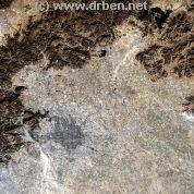
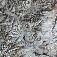
Simatai Great Wall of China - Satellite Image Site Map
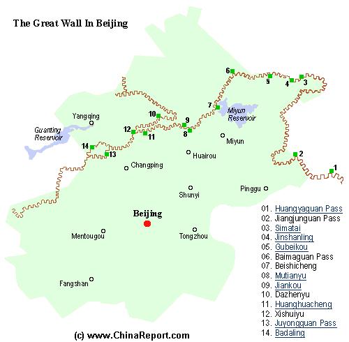
A Schematic Map of Beijing City Province and ALL Locations of The Great Wall of China visitable within Beijing City Province and Immediate Vicinity. Find the Great Wall at Yellow Cliff (HuangYaGuan), JiangJun Guan, Simatai, Jinshanling, Gubeikou, White Horse Pass (Bai Ma Guan),Beishicheng, Mutianyu, Jiankou, DaZhenyu, Huanghuacheng, XishuiYu, Juyong Guan Pass and Fortress and finally Badaling.
Browse the Map and Click through the Links for further backgrounds on each Great Wall Site, including photos, video, history and most importantly: site maps, and information on how to travel and get there by Public Transport or just on your own or traveling by Car.
Adjacent Map gives direct access to the City of Beijing Map by Google Earth.
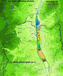
JiangJun Guan - Generals' Pass Great Wall of China Site Map, Overview Map of Jiangjunguan depicting the entire Valley with the Newest Village in the South, the New Village in the Middle, and the Old Town Area in the North just inside the Great Wall of China at Jiangjunguan Pass.
Map includes all Beacon Towers and both the Western and Eastern Sections of the Great Wall of China at Generals' Pass.
More Details will be added when available.
This page was last updated on: May 26, 2017
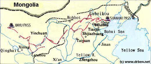
Below is a short listing of alternative Overview Maps of the Great Wall of China. The first miniature map only provides an overall impression of the entire length of the Great Wall of China and the main fortresses that supported it. From East to West these were Qinhuangdao (Shanhaiguan), Beijing, Zhangjiakou (Kalgan), Datong, Yulin, Yinchuan, Lanzhou, Wuwei, Zhangye and Jiuguan and Jiayuguan.
The 2nd Map provides a rough schematic of the Great Wall of China as it existed during the Ming Dynasty (1368 AD - 1644 AD) and is combined with a Google supported Satellite Map of the remaining ruins that can be found today.
The third available Map provides a rough schematic overview of the "layers" of the Great Wall, as they were built by various consecutive Dynasties but generally for the same purpose.
A Full Google Earth Supported Map Overview of All Structures of the Great Wall of China from East to West, by DrBen.Net (c) ChinaReport.com and Google.com.
All Maps of the Great Wall of China in Gansu Province
Schematic Map depicting the multiple layers of the Great Wall of circling Beijing, then continuing into North Shanxi Province, passed YanMenGuan at Datong to PianGuan in the North-West Of Shanxi where it terminates at the Yellow River.The Great Wall continues westward through Shaanxi,Ningxia and Gansu Provinces.
Miniature Overview Map o/t Great Wall of China
The China Report map provides an overview of the various parts of the Great Wall of China and the main and most well-known visitable locations. In between of these points there are many more.
Cities in China provide better comprehension of the position of the Great Wall versus the various Cities of the Chinese heartland which it was built to protect.
Please note the outer layer stretching from the Korean Peninsula to Hohhot in Inner Mongolia. This stretch was added in the late Ming Dynasty as protection against Manchu.
China Report - Map of the Great Wall during the Ming Dynasty
A Satellite image of China and East-Asia, with a super-imposed schematic Map
of the location and Path of the Great Wall as constructed during the Reign of
the Ming Dynasty. Main Features are Names and locations location of Passes on the Great Wall of China, outer layer and inner layer. Includes Shanhai Pass, Huangya Guan (Yellow Cliff) Pass, JiYunGuan Pass, Ningwu Guan Pass, Pingxin Guan, YaMen Guan Pass, Pian Guan Pass, JiaYuGuan pass, YuMen Guan Pass (Jade Gate) and Yang Guan Pass.
Further included for reference are City names, geographical features of landscape and main mountain ranges. Updates occur several times a year adding new pass locations and photo-virtual tours of Passes throughout China.
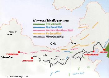
Map of the Great Wall China - Layers of Dynasties and Era's
A Schematic Map of China and East-Asia, with a super-imposed schematic of the various layers of the Great Wall of China.
Features Pre-Qin Dynasty Wall, Qin Dynasty Wall, Western Han Great Wall of China, the (Northern) Jin Dynasty Great Wall and finally the Ming Dynasty Great Wall as mainly remains today.
Main Features are Names and locations location of Passes on the Great Wall of China, outer layer and inner layer. Includes Shanhai Pass, Huangya Guan (Yellow Cliff) Pass, JiYunGuan Pass, Ningwu Guan Pass, Pingxin Guan, YaMen Guan Pass, Pian Guan Pass, JiaYuGuan pass, YuMen Guan Pass (Jade Gate) and Yang Guan Pass.
Further included for reference are City names, geographical features of landscape and main mountain ranges. Updates occur several times a year adding new pass locations and photo-virtual tours of Passes throughout China.
All Maps of the Great Wall of China in Ningxia Hui AR
All Maps of the Great Wall of China in Shaanxi Province
All Maps of the Great Wall of China in Shanxi Province
All Maps of the Great Wall of China in Hebei Province
All Maps of the Great Wall of China in Liaoning Province
All Maps of the Great Wall of China in Tianjin City Prov.
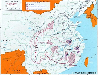
China Historic Map - Route Long March 1934/35 - 1A
A Schematic overview Map of the current Peoples Republic of China depicting the main route(s) of the epic Long March of 1934 and 1935.
Map clearly delineates PRC China current National borders and includes Provinces and Autonomous Regions, Main Cities and relevant Towns, initial Communist Soviets (Self-administered rebel areas), the routes followed by various elements among the Communist Groups and Armies, locations of important meetings points, main natural obstacles such as mountain ranges, the flow of large rivers such as the Yangtze River and Yellow River, position of the Great Wall of China in Gansu Province, Ningxia Hui Autonomous Region, North Shaanxi Province etc, rough estimated routes of main railroads of the time and other details of interest.
Mouse over locations and link through for additional information on each location.