This Satellite Image clearly shows Beijing City ( the dark grey blob left and low off-center ) enclosed by its Surrounding Mountains. In the North-West of the City Outskirts the huge hand-dug Kunming Lake, part of the Summer Palace Park on the outer edge of Haidian District is clearly visible. Further away almost due North of Beijing Badaling pass, a Great Wall of China location is clearly distinguishable with the Ming Tombs Valley stretching to its South-East.
Almost in the middle of the Upper Half of the Image , The Giant Miyun Reservoir, source of the City Water-supply is easily found.  The Great Wall at Simatai is just North-East of the Lake, well within the Mountain Range. East from there lies the steep Great Wall at Mutianyu, another Pass along the Great Wall of China near Beijing. Use our adjacent Great Wall of China- and Great Wall at Beijing Site- Maps for further understanding of the Immense Great Wall Monument.
The extensive Yiheyuan Summer Palace and Beijing Capital Airport, an equally large area are highlighted. Chengde Summer Palace (Bishu Shanzhuang) lies outside this Map. 
Mouse over Image to Reveal Name Information
To the Full Muntianyu Photographic Walk
Introduction to Satellite Image of wider Beijing Municipality North
East
Mouse over Image to reveal Monument Location Details
The Great Wall at Mutianyu , a magnificient section of the Great Wall of China some 75 kilometers outside Beijing City.
13 Ming Tombs + Badaling Great Wall of China Area Map
Mouse over Image to reveal Monument Location Details
Satellite Image of North-Eastern China and Mongolia with the path of Great Wall of China through China. Location and Passes highlighted-  for your reference, by The China Report
TiananMen Square
Beijing Capital Airport
13 Ming Tombs Mausoleum Valley
Badaling Great Wall Introduction
Yiheyuan Summer Palace Introduction
Simatai Great Wall Report
Tiantan Temple of Heaven Introduction
Mutianyuh Great Wall Report
Go to www.drben.net webring
ChinaReport.com at
To Main Menu of All Websites at DrBen.Net
Wanping Village - MarcoPolo Bridge
Click Map to Zoom and View Details
Great Wall of China Map
Old Summer Palace (YuanMingYuan) Introduction
This page was last updated on: June 6, 2017
My Great Web page

View AsiaReport.com - Mastermap of Asia (entire). in a larger map
Go to www.drben.net webring
See & Browse ALL Great Wall Locations near Beijing on 1 Map !!!
Map Great Wall of China - Beijing City Province - All Locations + Maps
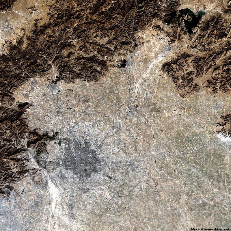
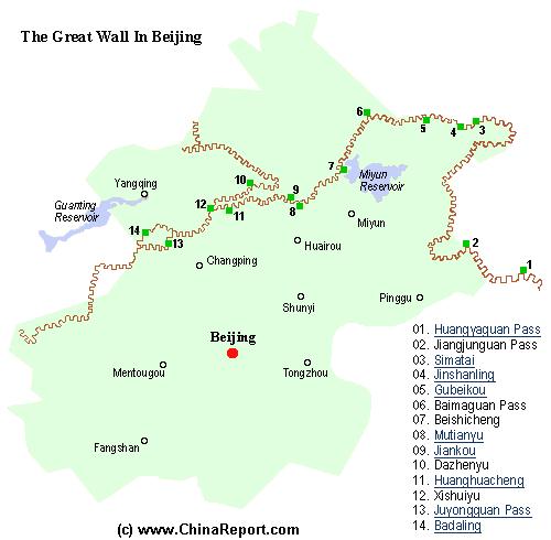
A Schematic Map of Beijing City Province and ALL Locations of The Great Wall of China visitable within Beijing City Province and Immediate Vicinity. Find the Great Wall at Yellow Cliff (HuangYaGuan), JiangJun Guan, Simatai, Jinshanling, Gubeikou, White Horse Pass (Bai Ma Guan),Beishicheng, Mutianyu, Jiankou, DaZhenyu, Huanghua-cheng, XishuiYu, Juyong Guan Pass and Fortress and finally Badaling.
Beijing Landmarks
Beijing Introduction
Beijing Online Sources
Beijing
Beijing Home
Beijing Hotels
Beijing Maps - Index
Beijing Public Transport
City Province Transport
Beijing by District(s)
Chongwen
ChaoYang
Dongcheng
Fengtai
Haidian
XiCheng
Xuanwu
6 Outer Suburbs
TiananMen Square
Alphabetical Order
By Function(s)
Forbidden City
Hebei Province
Hebei Province Home
China Offline Sources
AsiaReport.com Home
China Report Home
China Online Sources
China Online Store
China Maps
China
China Photo Galleries
China Report Club
4 Rural Districts
Shijingshan
Maps of Chaoyang
Maps of Chongwen
Maps of Dongcheng
Maps of Fengtai
Maps of Xicheng
Maps of Xuanwu
Maps of Haidian
Maps of Shijingshan
Beijing Great Wall Maps
Beijing North China Maps
Historic Maps of Beijing
BJ Public Transport Maps