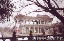
A wintery and snowy introduction to the magnificient Summer Palace museum at the North-
Beijing Municipality Area Maps
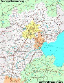
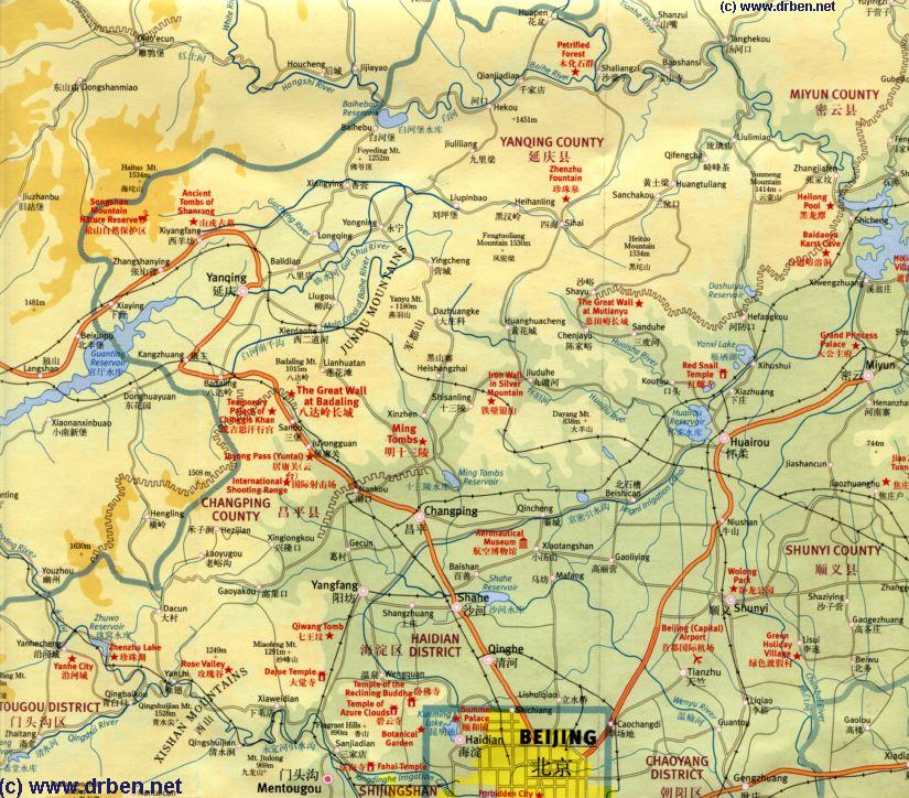
A map of the Northern Half of Beijing Municipality
( Beijing is an autonomous City Province ) including the Summer Palace, Jundu Mountains and The Badaling Great Wall of China, Mutianyu Great Wall of China and more details. Same Map of the Northern Half of Beijing Municipality,
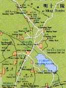
Shisan Ling 13 Ming Ming Dynasty Tombs at the foot of the Jundu Mountains and The Badaling Great Wall of China, nearby at the Juyung Pass 20 kilometers away.
Outside of Beijing City lies the City Province (Municipality) of Beijing, where there are even more worthwhile monumental, historical and scenic sites to visit and enjoy.
Starting with an Introduction and Overview of the Cities' Province and its facts and figures, this text Reviews the highlights and Main Scenic Sights to be visited in and around The Province. From those Monuments located nearest Beijing and those most well-known, to the remote and more obscure this pages gives a short but thorough introduction to Beijing City Province and its historic Monuments.
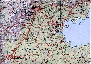
Covering a surface area of 16 Thousand 800 Square Kilometers (6.487 sq. Miles) Beijing Municipality is one of China's 4 large City Provinces. To the South-East lies Tianjin Municipality and all other surrounding area's are taken up by Hebei Province.
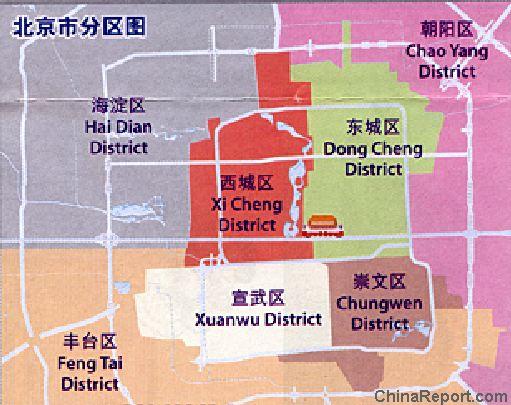
Today Beijing Municipality counts some 15 Million + inhabitants, spread over 16 Districts and 2 Townships. For proper understanding and easy navigation and travel throughout the Province however, it is easier to see things in a slightly simplified perspective.
The first Layer consists of the Inner Suburbs of Beijing, some of who's Monuments used to demand quite some traveling time and in practice lay at quite some traveling distance from the Ancient Walls of the Ming and Ching Dynasty Capital, and the Central City Center within the 2nd ring road.
Although until at least 2002 AD, the Northern Parts of Haidian District including both Summer Palace locations were in practice part of the Province rather than the City, in recent years this situation has been dramatically changed by the advent of modernity in Beijing
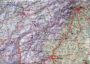
Hebei Province Map 2 - Geographic Map
A Geographic Map overview of North-East China's Hebei Province entire, delineating Hebei Provincial Borders, Beijing City Province, Tianjin City Province and parts of neighboring Shanxi-, LiaoNing- and Shandong Provinces and Inner Mongolia AR. Map includes Great Wall of China Locations in Hebei Province, Main Cities and Towns (shown by size), Hebei Province Monuments, Main Mountains (with Height), major highways, railroads, waterways, and Airports (National & International) and links to furher information.
An Introduction and historic backgrounds to each Beijing City District with Menus accessing each Landmark, Monument or Hot-spot Photo-Report, Maps and Sources.
Airport Expressway
2nd Ring Road
3Rd Ring Road
4Th Ring Road
and an explosion in infra-structure spending. Blessed with the new Beijing City Public Transportation System as well as a remarkably expanded highway and road network the first three of these districts (Chaoyang, Haidian and Fengtai) are now well integrated and to be considered part of the City rather than the Province.
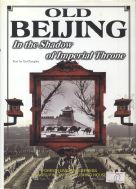
Take a photographic tour with novice level Historic explanation of this important Cultural Relic that was home to the Imperial Throne of the later Ching Dynasty (after the Burning of The Old Palace in 1890) and the place from where the most hated and notorious woman in China's history , Empress-Dowager Hsu Tsi ,wielded her Powers.
The Village of Shunyi lies due North of the Chaoyang Business District and is the home of its very own architectural marvel, the renewed Capital Airport with its stunning new Terminal and great rail and subway connections to all Northern Districts. Apart from the airport Shunyi County is mainly an industrial zone, the location of some of the infra-structure and logistical business that serve the citizens of Beijing.
The Shunyi District, which is named after its main Village, covers a 1021 Square Kilometers in Total, in the past much of it rough or agricultural, but today much more developed in including a fully modern infra-structure system, not only of highways, but of postal services, electronic connections, power facilities, water supplies and gas pipelines.
According to the City Government some 29% of the Shunyi District is still covered with Forests, while by 2011 about 50% of the surface area has been developed for some kind of human use.
As may have been deduced from the above, their are no major historic monuments or architectural wonders to marvel at in Shunyi, except for the now famous 'Olympic' Terminal 3, which is a giant building almost too big to appreciate as the work of art that it is. The design is best appreciated from the air. As may be the Shunyi District itself. When leaving from Capital Airport at night, the highways of Shunyi District with thousands of cars rushing along in order make up a remarkable view.
Among things Shunyi District is home to the Tianzhu Development Zone, which is located in the region abutting the Capital International Airport to the west. Inside the Tianzhu Development Zone is the largest international exhibition center in China, opened in early 2008 AD. Further sub-divisions in the types of Industry have been made by the City Government in order to speed along Development. The Five main subdivisions that apply to Shunyi are: 1) The airport related high tech industries, 2) Modern Service Industries, 3) Modern Manufacturing industries, 4) Modern Agriculture, and 5) Urban beverage and food industries.
Naturally all of these can be found according to the most auspicious and efficient location.
The airport related high tech industries have been reorganized during the construction of terminal 3 in advance of the 2008 Olympic Games in Beijing. As can clearly be seen when taking the Airport Expressway into Town many of these industries have now been brought together in what is known as "Beijing Shunyi Airport City" and "Beijing Tianzhu Export Processing Zone". The airport city in total measures 86.5 square kilometers in size of which some 25 square kilometers are part of the core Zone, with many security restrictions. The Beijing Shunyi Airport City has been growing fast in capacity, and by 2011 an estimated 150.000+ people will be working and living in this industrial zone. Although now listed as an industrial zone, there are however many parts of Shunyi, and the airport city which are very beautiful, rural and comfortable for living and leisure.
Beijing and its economy however does not rely merely on its Airport. Shunyi District is also home to the Beijing Automobile Manufacturing Base, representing the second type of Industry found in today's Shunyi. Since its founding in the year 2003 this zone especially has contributed for a large part to the thriving of the economy of the City of Beijing. Apart from a manufacturing zone, there is a seperate logistics warehousing zone, another zone for spare parts and a fourth sub-zone for public facilities serving the auto-making industry. By 2015 AD the Automobile manufacturing zone in Shunyi is expected to reach the size of 15 square kilometers, up from a mere 6.3 square kilometers in 2005. Meanwhile, some other industries have moved into the base. These are the biological pharmaceutical industry and some photo-electric manufacturing industries.
The Third pillar of Industries found in Beijing and the Shunyi District are the Modern Service Industries, which mainly means that in Shunyi there is a giant logistical zone connected directly to the Capital International Airport. Located on the northern side of Beijing Capital Airport are some 6.2 square kilometers entirely dedicated to the running of the airport and all it supplies and personnel. The new International Exhibition Center, opened in 2006, is the center point of public attention within this zone and is expected to become the largest and busiest such center in the entire Nation. Both the airport expressway, the airport express train connect directly to Beijing International Exhibition Center as does the No. 101 National Highway and the light railway under development in this district. Not visible to visitors but vital to its function, the logistic zone attached to the Airport City is among the most well-connected districts of the City. A Full wireless and optical network relays information to related industries and customs, keeping them informed by the minute on what comes in via Beijing Airport, or is set to leave.
Shunyi is no longer a village by all means and an industrial zone with lots of economic activities. In practical terms it has become an indispensable district of the larger Metropolis of Beijing. However, this does not mean that the Shunyi District has entirely shed all of its previous character as a rural village district.
The fourth pillar of Industry in Shunyi is that of modern agriculture, thrown together by the City Government in what is called the Three-High Agriculture Scientific and Technical Experiment Zone. Planned as early as the year 1995 AD, the agricultural zone has reached it full size at this time.
The Fifth and last pillar of Industry is dubbed the Urban Beverages and Food Industries by City Government. The main representatives of these are the Yanjing Beer Factory, which is a large complex found in Shunyi District, and the Huiyuan (Fruit) Juice Plant. This section of Shunyi Industrial base has also welcomed meat processing and packaging industries.
Apart from all this Shunyi County is also the location of the "Beijing Central Villas District", a extended neighborhood with luxury housing and villa's for both the local well-to-do and foreign expatriates. From west to east, the villas' of Shunyi County include EuroVillage, the River Garden, Le Leman Lake, Capital Paradise, Gahood, Yosemite - one of the earliest- and Dragon Bay Villa. The Villas' area is a suburban downtown area which includes its own set of mini shopping malls and entertainment central.
In the advent of the 2008 AD Olympic Games of Beijing a Rowing-Canoeing Park was constructed in the Shunyi District, now the busy sports facility of Shunyi Olympic Rowing-Canoeing Park.
Shunyi can be reached through the Subway/Metro system using the red line, connecting through SihuiDong Station Northwards on the Grey Line.
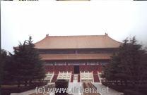
Ming Dynasty Tombs in Winter
Dwell around the 40 square kilometer Ming Dynasty necropolis some 50 kilometers outside the city of Beijing proper, a complex designed and built in the 15Th century Daoist-Confucianist style and home to the burial tombs of 13 of the total of 16 Ming Dynasty Emperors. Take the Introductionary Tour and follow up with a Full Walk through Chang Ling Mausoleum, the oldest Tomb lying Central in the Ming Tombs Valley, China's Valley of the Kings. Chang Ling is the burial site of Zhu Di, Emperor Yongle of the Ming Dynasty, one of the greatest Emperors that ever lived in China. Find out more about China's rich history, The Ming Dynasty and much more.
a natural resource of Tourism in the shape of the Ming Tombs. Although Tourism was relatively new in The Peoples Republic of China, during the 1990's a slowly growing trickle of tour-busses refreshed the village
economy with a new source of income in the shape of sales to to mainly foreign tourists. Among things a so-
called Jade Factory was set up in town, a modest tourist attraction where tourists could see how Jade was carved, learn about jade, and of course, buy the jades. The factory ofcourse was a cooperative of the Village People.
Much has changed since. At the start of the year 2000 AD plans were set into motion developing Changping from a mostly rural and remote
village into what it is not even 10 years later, a sprawling light industrial zone with many small factories and companies. Today's tour-buses view upon a different landscape and the Ming Dynasty Tombs, once a remote place, now receives 100's of thousands of visitors each year.
Ming Tombs Complete Site Map ( Ming Tomb Valley, ChangPing + Railroad Station)
Due South of the Historic downtown of Beijing lies the Daxing District. Daxing District (Simplified Chinese: 大兴区; Pinyin: Dàxīng Qū) was before an outlying city area but now is a suburb Beijing. Now connected through the subway/metro system, Daxing can best be seen as one of the satellite cities of Beijing. In the 1990's it was a remote urban area with few foreign visitors. Today, it remains a city section without much interesting sights of historic or entertainment value.
One worthwhile site to visit however is the Beijing Milu Yuan Park. Located near the Nan Hai Zi, or souther marshes of Beijing, the Park is home to the Pere David's deer (milu), a strange deerlike creature that became extinct in China toward the end of the Qing Dynasty Era (1644 AD - 1911 AD).
Currently the Milu Yuan Park functions as a biological research center that maintains a number of 200 Milu, who can be seen at the Park.
Webstyle produced NavBar
Source Book "Old Beijing - In the Shadow of (the) Imperial Throne"
The Fifth of the Outer Suburbs is the Fangshan District, best known by foreigners and Chinese alike for its Peking Man Site. Located near Zhoukoudian Zhen or Village is a congregations of Caves in which, in the 1920's, evidence of a primitive human creature was found. To be exact, the Peking Man Site was discovered by Svedish archeologist Johan Gunnar Andersson in 1921 AD and was first excavated by Otto Zdansky in 1921 and 1923 AD. unearthing two human teeth. Later to be determined to be archeological traces of an early specimen of homo erectus not previously known, the finds caused quite a stir worldwide and made Zhoukoudian famous in archeological history as well as Chinese National History. Eversince, the first finds, fissures in the limestone in the caves have yielded the remains of about 40 individuals as well as animal remains and stone flake and chopping tools. The objects and remains found vary between 200.000 years old and 750,000 years old.
Although famous and a National Relic, the Peking Man has disappeared literally into history. That is, when the long expected final Japanese Invasion and War of Japan against China began in 1937 AD, the Peking Man was in Beijing. In an attempt to move it out of harms way, the archeological relics were packed into wooden boxes and sent by train to Tianjin. The trail leads to the grounds of the Tianjin University, however after having arrived there the traces of Peking Man vanish. The whereabouts of Peking Man remain a mystery today.
Another one of the historic Monuments of Fangshan District is the Yunju temple, a Buddhist shrine complex with quite some reputation among Chinese Natives. With a stunning architecture and many pavilions and pagodas constructed along the foot of Mount Baidai, the Yunju Temple is certainly wortwhile a visit. It can be considered as one of the hidden Jewels of the City Province.
The Temple Complex apart from having precious Buddhist relics, including “Sakyamuni’s Bone” and 14,278 stone slabs with sculpted Buddhist sutras the Temple Complex features an array of historical structures. Among these, seven Tang Dynasty (618 AD - 907 AD) Era pagodas and five Liao Dynasty Era pagodas, all of them well preserved. Among these, the North Pagoda, dating from the (Khitan) Liao Dynasty, is a unique architectural wonder. The upper part is Bell shaped, and the middle part is in the shape of a drum.
The Sixth and Last of the Outer Suburbs is Mentougou District, a place of remarkable beauty.
Next in line clockwise around is the Tongzhou District which lies due South of Shunyi County and East of the historic downtown area's.
Tongzhou, the town is well-known among those interested in Chinese History for it is the location of the Northern End of China's "Grand Canal", a man-made waterway and trading route equal in historic importance to the Silk Road and even The Great Wall of China itself. First constructed during the 6Th Century Sui Dynasty (1271 AD - 1368 AD) and elongated during the Tang Dynasty Era (618 AD - 907 AD), the Grand Canal reached its longest length during the Yongle Reign of the Ming Dynasty. At that time, it connected the Capital of Beijing in the North all the way to Hangzhou in the lakes area of current day Zhejiang Province, a distance of about 1200 miles. Apart from Being a vital economic conduit during most of Chinese History, it was also a vital artery through which the grain supplies of the Capital City of Beijing were assured.
Find Tongzhou Town at some 12 kilometers due East from downtown Beijing. To be exact, Tongzhou Town today is considered the very (eastern) end of the longest and widest avenue in Asia, Beijing's famed Chang 'An (Eternal Peace) Avenue. One could get in a Cab at TiananMen Square and simply drive down to Tongzhou and Grand Canal Cultural Park for a surprise visit ! Since the year 2008, Tongzhou is also connected to the Beijing Subway System through an extension of Line 1, the red line that travels through the North of TiananMen Square, passed Oriental Plaza and along Dong Chang 'An Avenue.
Apart from the Grand Canal, Tongzhou District has the recently popular attraction of The Songzhuang artists' village or community, a place where many Chinese contemporary artists live and work. Mostly popular with those inspired by modern Chinese Art, the Songzhuan Community sprang up in the year 2003 AD in the midst of an economic boom and an influx of wealthy overseas investors interested in investing in the now highly popular Chinese Modern Paintings and the Like. Songzhuan Artists Community provides an alternative for the downtown art galleries of the Red Gate, Wanfung Gallery and the Forbidden City Art Gallery.
There are no popular historic sites to visit in Tongzhou Town or District.
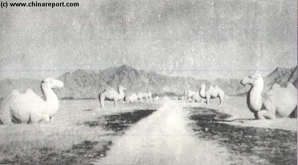
Changping District is located due North-West of Beijing across the Northern Borders of Haidian and is among the first destination of interest for most Tourists and Visitors since it is home to the 13 Ming Tombs (Shisan Ling) and the Badaling Great Wall of China.
Changping District (Simplified Chinese: 昌平区; Hanyu Pinyin: Chāngpíng Qū), was a County until 1999 AD. Covering an area of 1,430 square kilometers, the District has Changping Town as the Capital and counts two more towns - Nankou and Xiaotangshan, 26 townships, one state-owned farm and a special tourist zone.
The Village of Changping is located about 34 kilometers
Here lie the famed Western Hills of Beijing, at the foot of which lies the Imperial Pleasure Garden of the Imperial Summer Palace (YiheYuan) itself. The Western Hills extend throughout both Mentougou and parts of Fangshan District as well as a section of Shijingshan District and were once the luxury Home of Sir Reginald Flemming Johnston better known as the Tutor to the Dragon Emperor. Another famous temporary inhabitant of the area was Mao Zedong, who stayed in a Villa in the Fragrant Hills Park after the taking of Beijing in early 1949 AD (He later moved to Zhongnanhai). Eversince the western hills have become the home of the politically above, dotted with large villas and walled estates, as well as military bases and secret underground installations. Thus, there are several restricted zones within the district. these are not marked on any maps. There are quite a few not so often told stories to tell about the Mentougou District and its various landmarks.
Sir Reginald Flemming Johnston was the only western Tutor to the secluded last Ching Emperor, the boy Pu Yi. He left a unique account of the Court & Life in his Book "Twilight in the Forbidden City".
The Story of Deng XiaoPing, legendary Leader of Communist China and survivor of the Long March.
Buy it at Movie Universe - Click Here
Another worthwhile site to mention in Changping District is of a much more modern nature and is the (National) Aviation Museum. Not to be mistaken with the Aviation Museum of Beijing University in the Haidian District, the National Aviation Museum is located on the site of an old airbase once full of MIG's flying in defense of the Capital Beijing. At a distance of around 40 kilometers from the Central City it is now a large museum with a flashing display on Chinese Aviation History, air-defense, rocketry, the Korean Air War supported by China and more.
The National Aviation Museum was opened on the occasion of the 40Th Birthday of founding of the National Air Force and is the jewel in the crown of the Beijing Military. It is also known as the Air Force Museum.
Travel the distance and find the museum to inspect over 200 types of Chinese Aircraft. From early 20Th Century models to (just about) the very latest in Chinese Design. Naturally, the most recent developments are not included but this does not make the Museum any less worthwhile. For those who always wished to visit and inspect a communist Chinese airbase, here is truly unique opportunity. The only way to get there is to take Bus Line No. 912 at Andingmen station, and get off at the gate of the Aviation Museum directly. A Taxi Driver may not be familiar with the Place. Travel companies do not frequently offer tours to the base and museum.
Nearby is the Xiao Tang Hill (XiaoTangShan) which overlooks the base.
The last attraction of Changping County is the International Shooting Range. However, this is not a public or tourist facility.
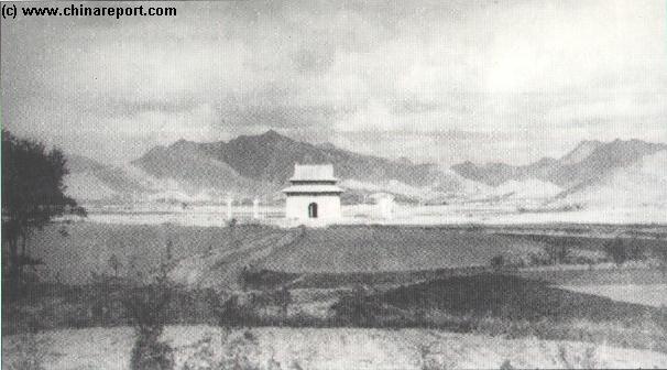
The Ming Dynasty Mausolea are a renowned World Cultural Heritage Site as they are the not only the 13 Burial Tombs of the Ming Dynasty (1368 AD - 1644 AD) Emperors, the ones that ruled from Beijing, they are also the only unique and preserved architectural remnants of such sites from the early Ming Dynasty surviving today, combining Confucian and Taoist ingredients. Apart from a Triumphal Gate and a long ceremonial causeway with statues of Animals, Generals, and Advisors, and the Ming Tombs Valley contains 13 burial sites. The most visited is the largest one, Chang Ling, the burial site of the Yongle Emperor who refounded Beijing as the Imperial Capital of the Ming. There are further an interesting and impressive Museum plus a whole rural valley to explore. Hiking in the area is greatly appreciated by many and it there are several trails through the surrounding area's. Although now much more developed, the Ming Tombs Valley is a Level 1 Protected site, and the valley -often shrouded
View of the Heavenly Way and the scenery of the Ming Tombs Valley in Changping County in the early 1900's AD. Ritual Animals start the Road to a Ceremonial Gateway and the Steles Pavilion.
in mist in winter- offers a great getaway from the City Noise and Bustle.
Equal in historic significance as well as Tourist Popularity is the Great Wall at Badaling and the Jujong Guan Pass and Garrison Fortress. Although technically just across the border of Changping in Yanqing County, both Sites can be visited in combination for an excellent day. Most Tour-bus Itineraries include both, direct bus-lines from the city have been in operation for years and apart from the Changping and Badaling train stations, there is now a Metro/Subway connection as well.
More original is to undertake a visit the Inner Layers of the Great Wall of China. Equally famous and historically working in conjunction with the Badaling Pass in the protection of the City of Beijing is the Nankou Pass. Although part of an Inner Layer, the Nankou Pass and Great Wall of China have seen considerable history, and the last battles fought on the Pass date from the Japanese Invasion of mainland China in 1937 AD.
Nankou was always the first or the last hurdle to be taken. Its Great Wall of China sites are mostly unrepaired and interesting to Visit. To walk along the entire stretch: head Southward out of the Ming Tombs Valley and find the Great Wall of Nankou Pass at the North-West corner of the Ming Tombs Lake Fresh Water reservoir and head due West from there. About halfway the Inner Great Wall lies Nankou Pass, through which now runs the Beijing-Badaling Expressway. Take the pedestrian walkway passing over the busy traffic and continue due West. After a while the Wall makes a barely noticeable turn to head to the South-West. This section ends at a place called Xilongkou,the next pass gate, due west of Gecun Village.
Apart from these main places of interest the Fangshan District has many scenic spots like Shidu’s mountains and waters, the unique Stoneflower Cave and a natural ancient forests in the Shangfangshan Mountains.
Fangshan is situated to the east of the Taihang Mountains. The east and south of the district is a fertile plain, with a narrow hilly area running from northeast to southwest. The district has many rivers and lakes among which the Juma river, Dashihe river, Yongding river, and Xiaoqing river. Although blessed with several water sources, the district, as does the entire city, experiences an increasing water shortage which is met by applying evermore ingenious solutions. Since 1998 AD Fangshan is under development as an industrial zone with no less than 345 companies and growing. Among these are many international companies, transforming the old Fangshan County into an
An Outline Geographic Map o/t Southern Regions of Beijing City Province and parts of Hebei Province. Map includes parts of Daxing, Fansghan and Mentugou Districts
integrated production area of the Beijing Metropolis. As a result many of its historic temples, towers and ruins have disappeared.
A last historic site in the Fangshan District are the the remains of the so called Jingjiao Christian Monastery of the Cross, one of the earliest Christian historic sites in China (and certainly Beijing) dating from the Yuan Dynasty (1271 AD - 1368 AD) Era. Not much however is published on this site at the moment and traveling there could be difficult.
An Outline Geographic Map o/t Southern & Western Regions of Beijing City Province and parts of Hebei Province. Map includes parts of Mentougou District, the Western Hills and Hebei and Shanxi province beyond.
On the Border with Hebei Province lie Miaofeng shan and Lingshan Mountain, the highest mountain in the entire Jundu Shan Range encircling Beijing. A most remote location of the Great Wall near Beijing, known as the "Seven Floor" Great Wall of China can be found in this area.
The Lingshan Mountain, with an elevation of over 2,300 meters (7,546 feet), is the highest mountain in Beijing and it has the reputation as 'Beijing's Mount Everest'. About 120 kilometers (75 miles) from downtown Beijing, it lies in the northwest of Mentougou District. The superb natural scenic area is renowned for its magnificent mountain peaks, a vast area of alpine meadow, and a rich resource of animals and plants. In the south the mountain faces the beautiful Baihua Mountain, and is close to the grand Longmen Gully in the east. Nearby is a rare attraction in the city of Beijing, the only farm in Beijing for Yak, Xinjiang fine wool sheep, and Yili
from the city center. In the recent past, until about the turn of the millennium Changping was a sleepy agricultural village blessed with
Especially of Interest to those involved with the Beijing City Economy, Beijings Yi Zhuang district is a Part of Daxing District that was developped as a High Technology Development Zone (See Map).
The Yi Zhuang Zone is located approximately 16.5 Kilometers (10 miles) to the South-East of central Beijing and by now is home to about 20 more enterprises ranked among the worlds top 500. Factories of YiZhuang Zone include Nokia, Coca-Cola, GE and car-maker Mercedes-Benz. Other industries are Pharmaceutical and Medical Companies.
The Special Development Zone has seen a rapid growth over the last few
Source Book
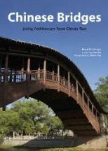
"Chinese Bridges Living Architecture from China's Past"
horse, a kind of sturdy horse. Find it located on an alpine meadow at an elevation of over 1,900 meters (6,234 feet) inside the valley.
This area awaits you with tempting scenery of plateau and grassland. The vast alpine meadows resemble a green carpet covering the mountain top. There are 825 acres of woods and an abundance of rare plants and over 700 species of animals found here.
Foxes can be spotted, flocks of berghaan, squirrels, stirring hares, wild goats and mothers. The endangered species of rare brown-eared pheasants is aid to inhabit the area.
Hikers are advised to be aware of the wild boars, which can attack viciously especially when fostering their young.
To Travel to Lingshan Mountain take Bus Route Number 929 Zhi (929支) to Shuangtangjian (双塘涧), and then take a Taxi to the Lingshan Mountain (灵山自然风景区). One can also hire a Private Cab for a day and get there in style. Mind the gridlock of Beijing's Road's and go on Time !
Find DrBen and ChinaReport on Facebook with the latest from www.drben.net.
Beijings Yi Zhuang district is a Part of Daxing District that was developped as a High Technology Development Zone.
The Yi Zhuang Zone is located approximately 16.5 Km (10 miles) to the South-East of central Beijing and by now is home to about 20 more enterprises ranked among the worlds top 500. Factories of YiZhuang Zone include Nokia, Coca-Cola, GE, Mercedes-Benz, as well as Pharmaceutical and Medical.
years, becoming ranked among one of the countries finest and most important. It is a bit of an elite community.