The 4 Rural Districts of Beijing and the Great Wall :
Tongzhou District of Beijing Province :
The Six Outer Suburbs of Beijing :
[ Back to Top of Page ]
To www.drben.net - Webring on East-Asia
This page was last updated on: June 10, 2017
The Six Outer Suburbs of the City of Beijing
Beijing Municipality Area Maps
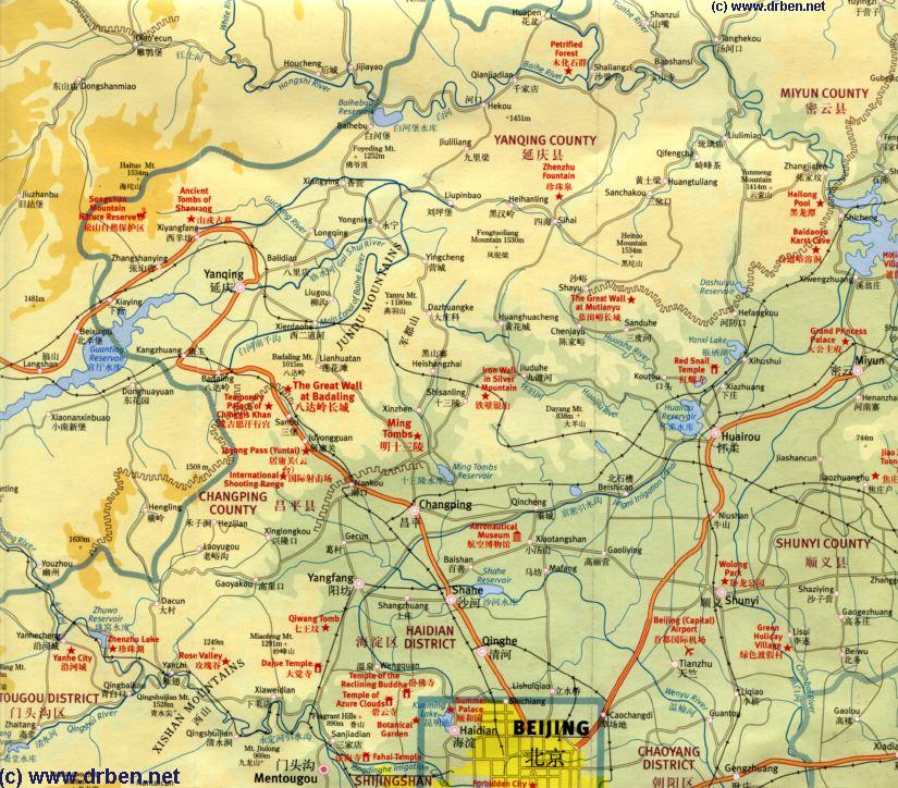
A map of the Northern Half of Beijing Municipality
( Beijing is an autonomous City Province ) including the Summer Palace, Jundu Mountains and The Badaling Great Wall of China, Mutianyu Great Wall of China and more details. Same Map of the Northern Half of Beijing Municipality,
but now viewable in Great Detail.
                      Satellite Image of the
                       Northern Half of Beijing Municipality.
                    Larger Area , but
                 roughly same as our
                      above Maps. A map of
                     a Section of the
                       Northern Half of
             Beijing Municipality
centering on the
Shisan Ling 13 Ming Ming Dynasty Tombs at the foot of the Jundu Mountains and The Badaling Great Wall of China, nearby at the Juyung Pass 20 kilometers away.
Click to View Satellite Image of Greater Beijing Area
- Go to Outside Beijing Maps at Bottom of this Page -
Webstyle produced NavBar
ChinaReport.com at
To Main Menu of All Websites at DrBen.Net
[ Back to Top of Page ]
Click Map to go to FULL Version !!
Hebei Province Map 2 - Geographic Map
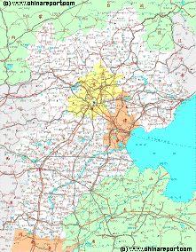
A Geographic Map overview of North-East China's Hebei Province entire, delineating Hebei Provincial Borders, Beijing City Province, Tianjin City Province and parts of neighboring Shanxi-, LiaoNing- and Shandong Provinces and Inner Mongolia AR. Map includes Great Wall of China Locations in Hebei Province, Main Cities and Towns (shown by size), Hebei Province Monuments, Main Mountains (with Height), major highways, railroads, waterways, and Airports (National & International) and links to furher information.
Full Geographic Map of Hebei Province, China !
The Six Outer Suburbs of Beijing are in clockwise direction Changping District (昌平区: Chāngpíng Qū), Shunyi District (顺义区: Shùnyì Qū) - with Beijing Capital International Airport, Tongzhou District (通州区: Tōngzhōu Qū), Daxing District (大兴区: Dàxīng Qū), Fangshan District (房山区: Fángshān Qū) and finally Mentougou District (门头沟区: Méntóugōu Qū).
The Tongzhou District lies due east of the old central city of Beijing and its now modern Chaoyang Business District, As with all outer suburabs previously mainly a rural region mostly known for the scenery of the Grand Canal and (former) Imperial Hunting grounds of the Qing Dynasty (1644 AD - 1911 AD), over the recent decade Tongzhou has been developed into a satellite city of Beijing full of highrises,
Read more on the Rural Parts of Beijing City Province and the Various Locations of the Great Wall of China near Beijing please Click through to "Beijing City Province - 4 Rural Districts and The Great Wall" - Click Here !
Geographic overview of the Region surrounding Beijing focussing on the Northern Half of Beijing City Province. Check the Map for better understanding of text.
historic or entertainment value.
One worthwhile site to visit however is ....
Return to: 6 Outer Suburbs of Beijing - Menu
Find DrBen and ChinaReport on Facebook with the latest from www.drben.net.
DrBen Nijhoff | Maak je eigen badge
Beijing Landmarks
Beijing Introduction
Beijing Online Sources
Beijing
Beijing Home
Beijing Hotels
Beijing Maps
Beijing Public Transport
City Province Transport
Beijing by District(s)
Chongwen
ChaoYang
Dongcheng
Fengtai
Haidian
XiCheng
Xuanwu
6 Outer Suburbs
TiananMen Square
Alphabetical Order
By Function(s)
Forbidden City
Hebei Province
Hebei Province Home
China Offline Sources
AsiaReport.com Home
China Report Home
China Online Sources
China Online Store
China Maps
China
China Photo Galleries
China Report Club
4 Rural Districts
Shijingshan
Changping
Mentougou
Tongzhou
Daxing
Shunyi
Fangshan