13 Ming Tombs + Badaling Great
Wall of China Area - see other Maps for more details.
This Map of Beijing's surrounding Area's depicts All Area's in between of Beijing City Center
( TiananMen Square ) in the South and Central, Qingbaikou Village in the West , The Large Guanting Fresh Water Reservoir in the North-West , Huapen Village and Petrified Forest near the Northern Border of Beijing Municipality , The Miyun Reservoir in the North-East near Simatai Great Wall , GubeiKou Great Wall and JingshanLing Great Wall. Finally Xiadian Village lies just beyond the Eastern Border of Beijing Municipality in Hebei Province.

View AsiaReport.com - Mastermap of Asia (entire). in a larger map
Introduction to Beijing Area Map 1 - North of Beijing Municipality
Click to Enlarge Further
General Map of the Ming Tombs ( Shisan Ling) & Badaling Pass Area
A Map of the Entire Summer Palace Museum Grounds and Park
A map of the The Greater Ming Tombs ( Shisan Ling ) and Badaling Pass and Great of China Wall Area.
Accurate Map of The Imperial Summer Palace Park & Museum Grounds, including names of all Pavilions and the area of Kunming Lake and shores.
Click Map to Enlarge Further
To The Beijing Reporter
Summer Palace
Museum
Great Wall at Mutianyu
Great Wall
at Badaling
Ming Tombs
Click to Open Satelitte Image in Seperate Window
Satellite Image of Beijing North
A Satellite Image showing roughly the same area of Beijing Municipality North as seen from Space. Mouse-over-Effect highlights exact locations at the Great Wall and other Monuments outside the City.
Go to www.drben.net webring
ChinaReport.com at
To Main Menu of All Websites at DrBen.Net
MiYun City, Miyun District, 4 Rural Counties, Beijing City Province.
YanQing (City), Yanqing County, 4 Rural Counties, Beijing City Province.
ChangPing (Village)
HuaiRou (City), Huairou District, 4 Rural Counties, Beijing City Province.
Old & New Beijing Capital Airport
Forbidden City - Palace Museum
Great Wall GuBeiKou
JuYongGuan Fortress
Petrified Forrest Site
Temple of Enlightenment (Dajue Si), Mentougou District
Shunyi District
Chaoyang
District
Changping
District
Mentougou
District
Haidian
District
Shunyi Village
Miyun County
Yanqing County
Mentougou Village
Huairou District
Shijingshan
District
Beijing Botanical Gardens (Haidian District)
Temple of Recling Buddha
Temple of the Azure Clouds (Buddhist)
Fahai temple (Shijingshan District)
China Aviation Museum aka National Aeronautical Museum (Changping District)
Rose Valley (Mentougou District)
Yanhe City Ruins (Mentougou District)
This page was last updated on: June 6, 2017
My Great Web page
To The Beijing Reporter
Beijing Landmarks
Beijing Introduction
Beijing Online Sources
Beijing
Beijing Home
Beijing Hotels
Beijing Maps - Index
Beijing Public Transport
City Province Transport
Beijing by District(s)
Chongwen
ChaoYang
Dongcheng
Fengtai
Haidian
XiCheng
Xuanwu
6 Outer Suburbs
TiananMen Square
Alphabetical Order
By Function(s)
Forbidden City
Hebei Province
Hebei Province Home
China Offline Sources
AsiaReport.com Home
China Report Home
China Online Sources
China Online Store
China Maps
China
China Photo Galleries
China Report Club
4 Rural Districts
Shijingshan
Maps of Chaoyang
Maps of Chongwen
Maps of Dongcheng
Maps of Fengtai
Maps of Xicheng
Maps of Xuanwu
Maps of Haidian
Maps of Shijingshan
Beijing Great Wall Maps
Beijing North China Maps
Historic Maps of Beijing
BJ Public Transport Maps
Map of Great Wall in Beijing 02 !
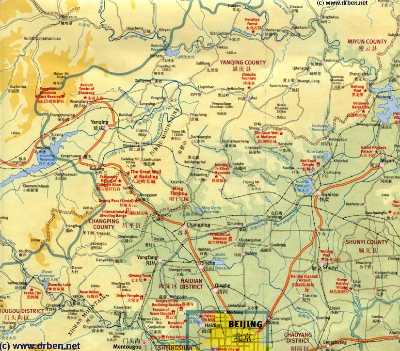
Additional Map of all Great Wall of China locations within the Province of Beijing City itself, excluding all of surrounding Hebei Province. Map clearly marks all sections and their position in relation to other neighboring and nearby sections. This Map is good for gaining more specific knowledge of the Great Wall, the northern outer suburbs and counties in which each section is located. Refer to adjacent Great Wall of China Google Map to navigate your way to each and every identifiable ruin(s) of the Great Wall within the outer suburbs and rural districts of Beijing City Province.
Schematic Map Great Wall of China locations in Beijing City (Province) 02A
See & Browse ALL Great Wall Locations near Beijing on 1 Map !!!
Schematic Map Great Wall of China locations in Beijing City Province 01 - All Locations
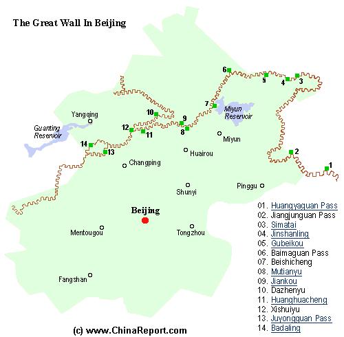
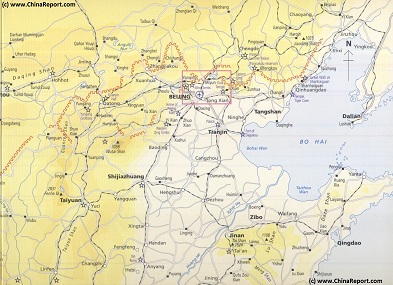
A Schematic Map of Beijing City Province and ALL Locations of The Great Wall of China visitable within Beijing City Province and Immediate Vicinity. Find the Great Wall at Yellow Cliff (HuangYaGuan), JiangJun Guan, Simatai, Jinshanling, Gubeikou, White Horse Pass (Bai Ma Guan),Beishicheng, Mutianyu, Jiankou, DaZhenyu, Huanghuacheng, XishuiYu, Juyong Guan Pass and Fortress and finally Badaling.
Browse the Map and Click through the Links for further backgrounds on each Great Wall Site, including photos, video, history and most importantly: site maps, and information on how to travel and get there by Public Transport or just on your own or traveling by Car.
Schematic Map of ALL Great Wall sites around Beijing and Tianjin City !
Map Schematic Hebei-Beijing-Tianjin Great Wall Locations
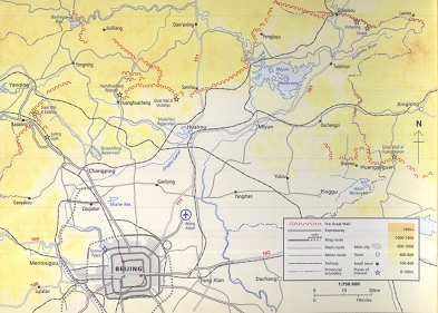
Schematic Map overview of Great Wall locations & sections in Shanxi-, Hebei Province, Beijing City Province, Tianjin City Province & parts of Liaoning Province. This Schematic Map focusses on the seperate visitable Great Wall of China locations + sections within these regions.