Welcome to the Beijing Historic Maps Menu at China Report.com / www.DrBen.net.
The Below Menu Page gives Quick and Easy Direct Access to All Historic Maps used in
THE BEIJING REPORT, a part of ChinaReport.com.
All Maps are published in support of the Information and Photos in our Growing List of Online Reports and Photo-Virtual Reports on The City of Beijing and its many Landmarks, Monuments, Hotspots and the Like.
Or use the Below Google Search Box Below to Search Directly for your Subject within www.DrBen.Net and ChinaReport.com
Introduction to Beijing Historic Maps Menu
Beijing Historic Maps at Beijing Report
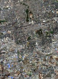
A Satellite based Birds Eye View of Beijing City Center, with the (Old) Names and Locations of Former City Gates, the City Moat, the Grand Canal at Beijing, The 19Th Century European Legations Quarter and More. Clearly depicted Ancient Imperial City, City District Borders + City Landmarks.
Original Ground Plan of The Imperial Capital City during the Ming- and Qing-Dynasties. Situation as until 1949 AD with explanation, names and appropriate links to Reports and Further Information.
ChinaReport.comat
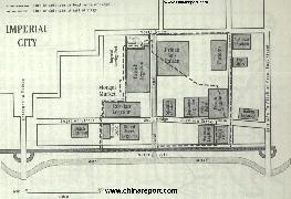
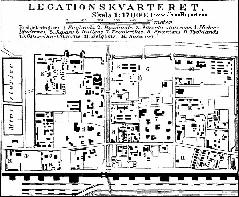
Map of The Beijing Legations Quarter in 1900 AD - Boxer War
Schematic Map of the 1900 AD Beijing Legation Quarter, between 1861 AD - and 1919 AD home of the Colonial Embassies in Beijing,
Map depicts the South-East Corner and Borders of the Imperial City and the much smaller TiananMen Square of 1900 AD. Further on this Map the Location of Legations of Various European and other Colonial Nations plus Todays remaining remnants and sights of the Beijing (Former) Legation Quarter.
Short Summary of Streets in the Legations Quarter with their historic relevance is included !
Compare with other histroical maps of Beijing. Read More details on each location within the Legations Quarter in the 11 Page Report on the Legations Quarter of Today.
A Schematic Map of the Old City of Beijing in the Qing Dynasty -stuation as until Summer of 1900 AD.
This Map includes Beijing Ming Dynasty City Walls surrounding Doncheng District and XiCheng District and enclosing the Imperial City.
Further: The Qing Dynasty City Wall additions surroung The Xuanwu District and Chongwen District.
Last: Locations of (Former) City Gates, ancient Names of Gates and the Location of the City Moat and its Connection to the Grand Canal of the Ming Dynasty.
Map of The Beijing Legations Quarter in 1916 AD
Schematic Map of the 1916 AD Beijing Legation Quarter, between 1861 AD - and 1919 AD home of the Colonial Embassies in Beijing,
Map depicts the Former Legations Quarter including details of the Southern City Walls and Beijing's First Railway Station (QianMen) as well as the smaller TiananMen Square of 1916 AD. Further on this Map the Location of ALL Legations of Various European and other Colonial Nations plus Todays remaining remnants and sights of the Beijing (Former) Legation Quarter.
Short Summary of Streets in the Legations Quarter with their historic relevance is included !
Read More in the 11 Page Report on the Legations Quarter of Today.
Map of Beijing in 1916 AD - 1916 AD Beijing City Plan 1A
Schematic Map of the the City of Beijing in 1916 AD, shortly after the 1911 Xinghai Revolution and the Debacle of Yuan-Shi Kai's attempt to Crown Himself Emperor. Ex-Emperor Pu Yi still inhabited The Palace, outside Beijing was modernizing and China was experiencing the industrial Revolution.
Among the most noteworthy features of this Map are: 1) The QianMen Railway Station, at the Time the Main Railroad Station of Beijing. 2) The small station outside and West of XizhiMen Gate, built in 1905 AD and diverting the Central Watersupply of Beijing underground, 3) The Imperial City and the much smaller TiananMen Square of 1916 AD. This Map is one of the Few maps that shows the Pre'-Revolutionary Lay-out of Tian'AnMen Square. Further on this Map the First University of Beijing due East of Jingshan, the new University Campus north-west of Deshengmen, and finally the Location of "The Legations" of Colonial Nations plus Todays remaining remnants and sights of the Beijing (Former) Legation Quarter.
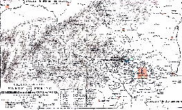
Map of the City of Beijing and Wider Region in 1875 AD
A Shematic Map of Beiping (Beijing) and wider City Province in the Year 1875 AD using the Old (and outdated) naming system. Map depicts major and minor roads, villages and Towns, Walled City of Beijing, Old and New Summer Palaces, The Fragrant Hills and the Western Hills, Tongzhou Village, Shunyi Village, Changping Village, the Ming Tombs Valley, Badaling Village, the Badaling Great Wall of China, Nankou Village, Nankou Great Wall of China Pass, and various other notable locations in the wider vicinity of the Capital of Beijing at the Time. Other details on this Map: mountains, lakes. There were no railroads in the area until 1899AD/1900 AD.
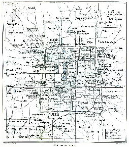
Map of The City of Beijing and Wider Region in 1912 AD
A Shematic Map of Beiping (Beijing) and immediate vicinity in the Year 1912 AD, using the Old (and oudated) naming sytem.
Map depicts major and minor roads, villages and Towns, Walled City of Beijing, Various Palaces of the Imperial Family, Temples, Mosques and Churches, The new railroad stations and lines such as Qianmen Station and Xizhimen Station both oustide the City Walls of Beijing, The Legations, buildings used by The Government of the First Republic of China, all city gates, outlying villages and roads, rivers in the region and more.
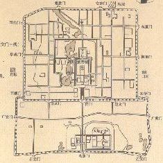
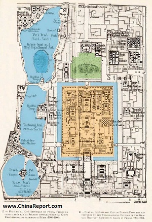
Historic Schematic Map of the former Imperial City in the center of Beijing with at its core the Palace Museum a.k.a. Forbidden City.
Includes Zhongnanhai, today best known as China's Secluded Leadership compound "ZhongNanHai" in 1900 AD when the Complex was still in function as an extension of the Imperial Palace of the Manchu Qing Dynasty (1644 AD - 1911 AD). At the time it was considered the realm of the Empress-Dowager Hsu-Tzi, who had the Emperor Guangxu imprisoned within (on Yingtai Island).
This Schematic Map depicts major structures within the Zhong Hai and Nan Hai Lake Complex. Additional names of structures of the time have been added.
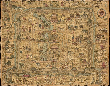
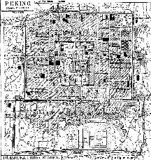
Map of Beijing in 1936 AD - 1936 AD Beijing City Plan
Schematic Map of the the Walled City of Beijing in the year 1936 AD produced for tourist purposes and as souvenir. The Map highlights the various Palaces, Main Temples and other monuments of interest within the city, as well various other spots of historic or commercial interest. Apart from a number of minor Temples and the still famous Hong Qiao thieves market, this map further depicts the various landmarks found just outside of the city walls, as well as the all important Grand Canal and the trajectory of the first railroad to service the city of Beijing and the first circular railway line that stood at the birth of today's hypermodern city-wide public transportation.
Click the various locations and elemnts on the map to go through and find more information, backgrounds and photo's on each location of your interest.