This page was last updated on: June 6, 2017
Dong'An Gate - Beijing Night Market
Dongjiaomin Church - St. Michaels
Pei Ta
NanTang - South Cathedral
Hotel Beijing - First International Hotel in Beijing (constructed 1900 AD)
Hu Yao Powder Mill
Haushi Si - West Flower Market Street Mosque
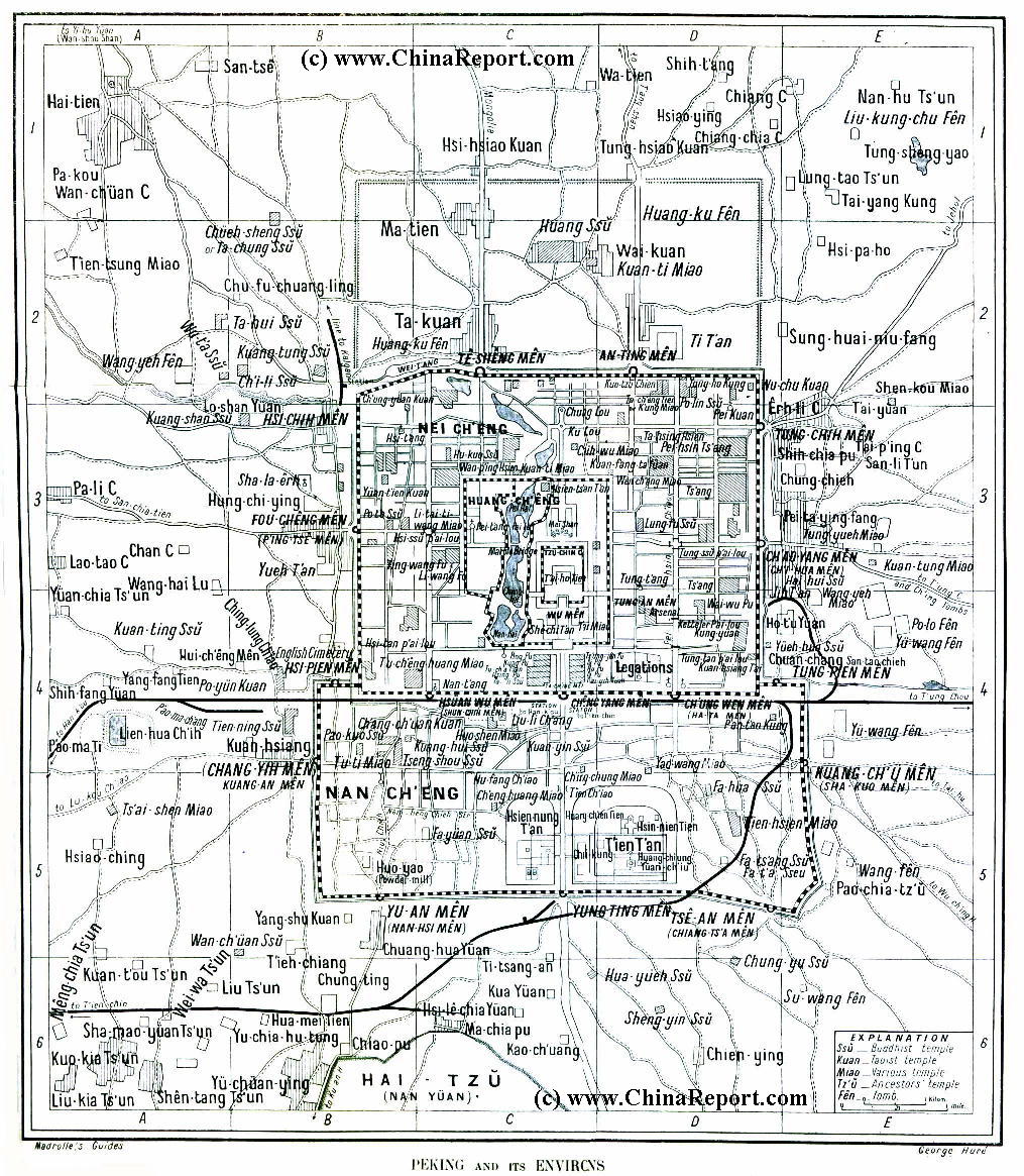
This Map clearly show the lay-out of Beiping - The Northern Capital (as Beijing was called at the Time), in 1912 AD, just after the End of the Qing-Dynasty and the 1911 AD Xinghai Revolution that overturned the 2000 Year Old Feudal Tradition. De-throned Emperor Pu Yi still inhabited The Imperial Palace, outside Beijing was modernizing and China was experiencing the industrial Revolution.

Among the most noteworthy features of this Map are: 1) The QianMen Railway Station, at the Time the First and Main Railroad Station of Beijing.
2) The small railway station outside and West of XizhiMen Gate, built in 1905 AD and diverting the Central Watersupply of Beijing underground. Today Xizhimen Station is Beijing North Station.
3) The Imperial City and the smaller TiananMen Square of 1912 AD. This Map is one of the Few maps that shows the Pre'-Revolutionary Lay-out of Tian'AnMen Square including the demolished ZhonghuaMen (now Mao Zedong Mausoleum) giving details on the functions of (government) buildings along both sides of the Square. Further on this Map, Peking University ("Beida") due East of Jingshan, the new University Campus north-west of Deshengmen, the Location of "The Legations" of Colonial Nations and finally the location of the Beijing Hotel, first International Hotel built in the City in 1900 AD.

Clearly visable on this Map from the year 1912 are the Feng Shui-important Central City Axis with from South to North : YongDingMen , QianMen , TiananMen, WuMen, The Dragon Throne, Coal Hill and Drum- and Bell-Towers. All other former Gates, ancient landmarks and temples are marked on the Map.
Click sections of map to highlight individual city districts of XiCheng, DongCheng, Chongwen, Xuanwu with The Imperial Palace (Forbidden) City in the Center and the (then) Villages of Fengtai and Chaoyang in the West and East.

XiCheng and DongCheng were part of the Inner City, the Southern Districts were considered outside the Imperial Capital City proper, as they lay south of Qian Men, the Front Gate. Both Chongwen and Xuanwu were brought inside the protection of a City Wall and Moat, during the early Qing Dynasty Years.
Introduction to Map Beijing (Beiping) City & Environs in 1912 AD
Designates Central Axis of Imperial City Plan.
BeiHai Park's - Jade Island
Lama Temple - YongHe Gong
Temple of Heaven & Park
QianHai
QianMen = Front Gate Inner City
Tian An Men
Drum Tower and Bell Tower
Go to www.drben.net webring
Jing Shan Imperial Garden (now a Public Park)
Altar of the Earth
Chongwen Men (Now Demolished)
Temple of Confucius
Imperial Academy & Hall of Classics
Dong Bian Men (DongNan Jiao Lou) Now Red Gate)
Altar of Agriculture (No Remains)
Wu Men - 5 Phoenix Tower
Nan Hsi Men
Yun Ting Men (Now Yongding Men - Restored 2004 AD)
Tse 'An Men or Chiang Tso Men
Sha KÓu Men - Sha Bridge Gate -Guan' Qu Men
He Ping Men (Now Demolished)
Shun Chi Men (XuanwuMen - Demolished)
Hsi Pien Men (Demolished)
Fu Cheng Men or P'Ing Tse Men (excavated remains)
Altar of the Moon
Altar of the Sun
Rice Paddies
Palace of Prince Ch'Un
Designates Imperial Family Mansion.
Yin Tai Palace (Prison Emperor Guanxu)
Hsi Chi Men (Xi Zhi Men)
De Sheng Men (Now a RingRoad Overpass + Road to Changping and Badaling)
An Ding Men (Preserved)
Tung Chi Men (Today Dong Zhi Men)
Observatory on City Wall Platform
Hsi Tan Chi ChÁng - Market
Chinese Imperial & Government Structures.
Main Menu Page to all Parts of the Forbidden City
Northern Mansion (Pei Fu) - Palace of Prince Chun
Department Home Affairs 1st Republic of China
Northern Mansion - Palace of Prince Chuang
Former Peking University (1903 AD)
Imperial Gardens , later Zoo
ChinaReport.com at
To Main Menu of All Websites at DrBen.Net
Chang Yih Men also Guang 'An Men (Demolished)
HanLin Acedemy 1860-1900 AD
Carriage Park of the Imperial City & Palace
Xu Wan Fu = Prince Xu TÚng Residencial Palace Mansion
Gong Wan Fu = Prince Gong Residential Palace Mansion
Fu Wan Fu = Prince Fu Residential Palace Mansion
Rice Paddies
TianNing Temple Pagoda - Temple of Heavenly Peace
Fayuan Si - Temple o/t Source o/t Law
QianMen Railway Station
ParliaMent Building 1st Republic of China
Xuanwu
Xicheng
Dongcheng
Chongwen
ChaoYang
Fengtai
Haidian
DonghuaMen - East (Flowery) Gate
ShenwuMen - Gate of Divine (Military) Might - North Gate
To Beijing Historic Maps - Index
Go to Next Page !
St. Savior- North Cathedral - Xishiku Cathedral
Chang'An Av.
Dashilar
QianMen
Hutong
TianQiao
Liu Lichang
St. Joseph - DongTang - East Cathedral
HongQiao
BaiYunGuan - White Cloud Taoist temple
Bao Guo Temple
Nui Jie' Si - Ox Street Mosque
Dragon Happiness Temple (Now only a Street)
Xuan Wu Men (Now Demolished)
Bell Tower
Dong Yue Miao - now Dong Yue Maio - Beijing's largest & most Popular Taoist Temple + Beijing Folklore & Art Museum
Russian Cathedral - North Cathedral - Beixin T'ang
Wang Yue Miao - now Dong Yue Maio Taoist Temple
This page was last updated on: June 6, 2017
My Great Web page
Beijing Landmarks
Beijing Introduction
Beijing Online Sources
Beijing
Beijing Home
Beijing Hotels
Beijing Maps - Index
Beijing Public Transport
City Province Transport
Beijing by District(s)
Chongwen
ChaoYang
Dongcheng
Fengtai
Haidian
XiCheng
Xuanwu
6 Outer Suburbs
TiananMen Square
Alphabetical Order
By Function(s)
Forbidden City
Hebei Province
Hebei Province Home
China Offline Sources
AsiaReport.com Home
China Report Home
China Online Sources
China Online Store
China Maps
China
China Photo Galleries
China Report Club
4 Rural Districts
Shijingshan
Maps of Chaoyang
Maps of Chongwen
Maps of Dongcheng
Maps of Fengtai
Maps of Xicheng
Maps of Xuanwu
Maps of Haidian
Maps of Shijingshan
Beijing Great Wall Maps
Beijing North China Maps
Historic Maps of Beijing
BJ Public Transport Maps