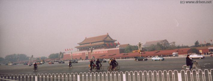
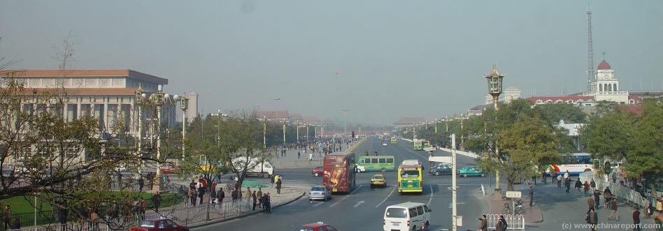
Tian An Men , or the Gate of Heavenly Peace at DongChangÁn Jie and TiananMen Squares Northern Flank. Behind the traffic at Beijing's busiest avenue , TiananMen and the Southern Buildings of the Forbidden City are clearly visible.
Welcome to the world famous and renowned TiananMen Square , the Square of Heavenly Peace at the political heart of China's People's Republic. Monuments include the Great Hall of The Peoples, Tian an Men, The Monument to the Heroes of the Revolution, the China National Flag, TiananMen The Gate and ofcourse the Famed Mao Zedong Memorial Mausoleum. Walk around the largest square parading ground in the World and enjoy the sights, sounds and sceneries.
A map of the wider TiananMen Square area plus Forbidden City Area and surroundings. A map of the wider Palace Museum / Forbidden City area , with the Palace Moat, Zhongshan Park and the Park of the Peoples Culture Included. Very Accurate Map of The Imperial Palace Museum Grounds, including names of all Pavillions and the area of Zhongshan Park and the Park of the Peoples' Culture
(Both between TiananMen en Wumen Gate)
No building left out !
TiananMen (Sq.) and Palace Museum Maps
Webstyle produced NavBar
ChinaReport.comat
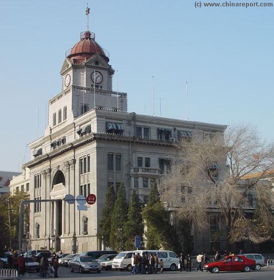
The Bank of China at West TiananMen Square, one of the few remaining buildings from the European Era in Beijing during the 19Th and 20Th Century.
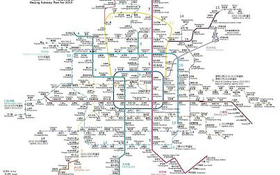
Full Map of the Beijing Subway System of 2008 AD - Click Map for FULL Version !
The Square of Heavenly Peace is located at the very Center of the City of Beijing, just South of The Palace Museum.
The Square can be accessed from all directions, North-South and West through several pathways and is reachable by Bus, Metro/Subway, Car or Taxi, Rickshaw or Bicycle and on Foot. Some daring Tourist have even been spotted on Skates, but this is hardly advisable with current traffic levels.
The Only Thing to Remember is that no vehicles are alllowed to stop, drop off passengers or park immediately at TiananMen Square, TianAnMen Gate, or the two flanks formed by the Great Hall and the National Museum. There are no Bus Stops at the Square nor a Subway Station. In other words - you can get there, but you can't get off.
The Easiest Road to The Square of Heavenly Peace
therefor leads by Subway. Get off conveniently near the Square by traveling on the Central Red Line to TiananMen East- or West-Stations, or by the Circular Blue line to end up at QianMen Station, on the very southern Tip of TiananMen Square.
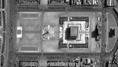
Please use the adjacent satellite image based Map of the Square of Heavenly Peace to navigate the Square, Monuments and various roads leading to and from the Square.
A View at the Square of Heavenly Peace, from the 1st Floor of Ming Tien Coffee Language, a now closed establishment with a certain grandeur.
Historic layout of The Square of Heavenly Peace
During the Times of the Emperors, the Square of Heavenly Peace was a much smaller and narrower Square, flanked on the sides by small shops, and lying in between of The Front Gate of the City in the South and The now World Famous Gate of Heavenly Peace in the North.
Once the Three Large and Colorful Gates of QianMen, Shenyangmen and the now destructed Gate of China (ZhongHuaMen)located on the Southern Half of today's Square of Heavenly Peace formed a Large Vaulted Structure which functioned as the South Gate leading to within the City Walls of the Capital.(Later during the Ching Dynasty, a further wall was erected around the southern districts of Chongwen- and Xuanwu, rendering YongDingMen the factual South Gate into the Capital).
What went on in the space between the Gate of the City Walls and the Northern End at the Gate of Heavenly Peace is not always very clear.
What is clear is that even in the earliest days of the Ming Rule and the establishment of the Ming Capital of Beijing, Eternal Peace Avenue - Chang An Jie' connected to the North End underneath the Gate of Heavenly Peace, the Southern and Ceremonial Entrance to the Palace of the Imperial Court (Forbidden City). As such it was one of the main thorough fares.
The space immediately in front of the Gate of Heavenly Peace, the South Gate of the Imperial City within which The Imperial Palace, served as the Place where the subjects, given shape in the citizens of the Capital down below, could receive the official communications from the Emperor, who's High Officials would read his message out from the High Up Platform of the Gate. Remarkably, the two White Marble Columns flanking The Gate of Heavenly Peace at the Square further refer to practice of reversed communications, the Poles being the officially designated place where the People could Petition the Emperor, and hopefully influence his policy or decision on certain matters.
South of and East of The Gate of Heavenly Peace, across from the Gate into The Imperial Ancestral Temple (Tai Miao) stood the buildings of the Imperial carriage park, after which followed a Reddened Gate of The Imperial City and a bridge over the Canal that lead south out of the Imperial City and down to the Southern City Wall. Beyond lay the extenses of East Eternal Peace Avenue - Dong Chang ' An Jie' leading away to as far as the JianguoMen Gate.
On the opposite of the Square of Heavenly Peace in the West stood an identical gate, this one without bridge and Canal, to lead away to West Eternal peace Avenue - Xi Chang' An Jie'.(Both Gates have now been removed to make way for the a wider Eternal Peace Avenue, and the Buildings of the National Museum and the Great Hall of the Peoples respectively).
Later in history during the advent of the Qing Dynasty, the Capital of Beijing saw it's first modernization, including some expansions of the Imperial City that affected the Northern Border of the Square of Heavenly Peace.
During the Reign of the Qing Dynasty the Imperial Palace with adjoining Parks & Gardens was enlarged several times, making for an elongated border of the Imperial City, which shifted both on the East Side- where the Imperial Library was constructed, and the West Side- where Zhonghai and Nanhai were connected to the Imperial Palace outer court by ways of a direct Gate and Bridge in between.
The second modernization of the City took place in the second half of the 20Th Century and the years after 1900 AD.
First, the Chinese Nation was opened to receive Foreign Influence in a large dosis by means of the English and Allied Victories in the first and second Opium Wars (1840 AD and 1856/60 AD), at the end of which Foreign Conscripts camped outside the The Gate of Heavenly Peace on the Square.
Then secondly by the Imposure of Foreign Embassies in the nearby Legations Quarter of Beijing, after the Arrow War of the Years 1856 to 1860 AD, signifying the completely giving way of Chinese Sovereignty to the Dominance of and Decision making by Foreign Powers such as Britain, France, Germany, Russia, Japan and the United States of America.
The Rule of the Foreigners was severely challenged in the Year 1900 AD, when Beijing and the Foreign Legations Section bordering the East Flank of the Square of Heavenly Peace became a central background in what was to become known as the "Boxer War". During the battles the Imperial Carriage Park was burned down, as were the Imperial Hanlin Academy of High Scholars on North Canal Street (Zheng Yi Lu) with it's priceless Library of Ancient Documents, Parts of the British Legation and the complete inventory of what was known as the Tartar Market.
After the War was through and the "7 Allied European Nations" Victorious, none of the buildings of the Eastern Flank Area of a war-torn Square of Heavenly Peace were restored and the wasteland that was created was later used for horse-riding practice by writing Foreigners and other leisure activities. Eastward, after some considerable distance, a large wall was constructed, to protect the Legations from any further attacks as they may occur.
The Wasteland remained until after the Revolution ended in 1949 AD with the Establishment of the Peoples Republic and the ensuing modernizations and enlargement of the Square.
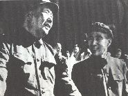
Chairman Mao and General Lin Biao on the Platform of the Gate of Heavenly Peace during May Day Ceremonies.
First to appear in the Space of the New National Square was the National Flag of China, which had been presented with due Ceremony on the October the 1st of 1949 AD. It had been there every day since. Subsequently, in accordance with the resolution of the First Plenary Session of the Chinese People's Political Consultative Conference adopted on November 30, 1949 the erection of the Monument to the Heroes of the Revolution followed, a lenghty affair that took place between August 1952 to May 1958.
Next Monuments, to be added in 1959 AD for the Tenth Celebration of the Peoples Republic of China, were the Marvelous and Monumental the Great Hall of the Peoples at the West of the Square of Heavenly Peace, shortly followed by the Construction of the Museum of the Revolution and the
Evening at The Square of Heavenly Peace with the Radiant illuminations of Gate of Heavenly Peace.
The Last and Major change to the face of The Square of Heavenly Peace to occur since The Revolution was the construction of Mao Zedong Memorial Hall between November the 24Th of 1976 AD and May the 24Th of 1977 AD when it was completed. The choice for the location for the Memorial Hall to preserve the Body of the Great Leader was made for the South Section of the Square. To make space for it, the inner-most section of the Former Front Gate, known as the Gate of China, had to be torn down.
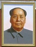
In the Place of the Old Gate and a considerable section of the space to the North beyond Rose the Mausoleum of Mao Zedong, which stands as the crowning piece of the square as a Monument until the current day. With it's completion, the complete Architecture of the Square of Heavenly Peace, all Monuments arranged and speaking in unison now proudly proclaim the Success of the Revolution in China, befought by the all mighty never relenting Communist Party of China under Guide of it's Greatest Leader of all Time, the Great Helmsman Mao Zedong.
For a short period of Time Law and Order returned to the Streets of Beijing and the Legations returned to full operations, in their process modernizing the City and the Nation beyond further. During this period of the Colonial Era in years that put a final end to the Rule of the Qing Dynasty, train lines were layed a-mass in the North-East of China, rapidly modernizing the Nation's transport network, and one of the main Stations to serve the Northern Capital was built right in the South of the Square of Heavenly Peace. This is the Old QianMen Station that still survives to this day as a reminder of the early advent of the industrial age in China. At the same Time other modernizations were made to the Buildings
A Historic Photo of the Square of Heavenly Peace taken from QianMen Tower to the North and West around the Year 1930 AD. Clearly Visible in front on the Left and West is the Building that would House the Bank of China after the Revolution of 1949 AD. In Front on the Right and East stands the low ZhongHueMen, the Gate of China that was demolished in 1976 ADto make way for the Mao Zedong Memorial Hall.
around The Square, seeing the rise of several European Styled Buildings. Still here today as remnants of that Time are a building that has served as the Beijing Office of the Bank of China for a long time after the Revolution. There was another large government office of European type architecture built away North-Western Corner of the Square of Heavenly Peace on West Eternal Peace Avenue, a part of the lot that is currently taken up by the North Wing of the Great Hall of the Peoples. On the East Flank of the Square, South of ZhongHuaMen - The Gate of China stood some further European facades of different natures.
At some Time there was also an electric tram installed at the South End of The Square of Heavenly Peace, which had it's route from North of QianMen Tower to lead into the City.
A Historic Photo of of the Gate of China, Zhonghua Men taken from the Platform of QianMen. The Gate of China was developped at the end of 1976 to make room for Mao's Mausoleum.
The Third and so far latest round of modernizations came immediately after 1949 AD, during the founding Years of the Peoples Republic of China in the early 1950's.
After Mao had held his speech, political ceremony and grand parades at the Gate of Heavenly Peace, making the Square once more the focus of Political Thinking in the Chinese Nation it was high Time for a new Square befitting the ambitions of the new and glorious Socialist Nation intended for the Future. As a result, the entire Square of Heavenly Peace was reshaped.
First of all it was enlarged, as were the boulevards leading up to it in the North and South. The widened boulevards leading to the Square, allowed for easy access for the Military Parades as well as large crowds of people attending Mass Political Rallies of the leading Communist Party, but the a price was payed by the need to demolish parts of the South Gate of the City. In a drastic and bold move it was decided to do away with the Ming Dynasty City Walls altogether, creating the First Ring Road of the New Communist Capital leading along the Path of the removed Walls.
Secondly, Grandiose Monuments to the success of the Chinese
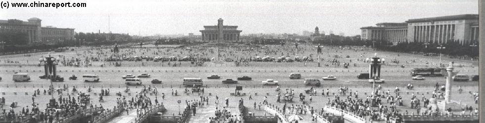
A Historic Black & White Photo of the Northern Section of Square of Heavenly Peace in 1979 AD. The Photo was taken from the Rostrum of The Gate of Heavenly Peace.
Click through adjacent Links to learn more about the Largest Square in the World and World History.
Easily navigate the various sections of the Square of Heavenly Peace, starting in the North and Ending Up in the very South around the Former Front Gate of the Imperial Capital of Emperors !
Today's Legation Quarter is the Home of the Beijing Municipality Government, the Headquarters of the Beijing Branch of the Chinese Communist Party and the heart of City and National Public Security Bureau. This Map shows both the structures of the Legations Quarter Area of Today and the locations of Former Legations + their and other Historical Remnants to be found in this corner of DongCheng District.
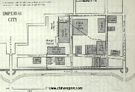
Map of The Beijing Legations Quarter depicting the Square of Heavenly Peace architecture in 1900 AD.
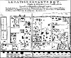
Map of The Beijing Legations Quarter in 1916 AD
Schematic Map of the 1916 AD Beijing Legation Quarter, between 1861 AD - and 1919 AD home of the Colonial Embassies in Beijing,
Map depicts the Former Legations Quarter including details of the Southern City Walls and Beijing's First Railway Station (QianMen) as well as the smaller TiananMen Square of 1916 AD. Further on this Map the Location of ALL Legations of Various European and other Colonial Nations plus Todays remaining remnants and sights of the Beijing (Former) Legation Quarter.
Short Summary of Streets in the Legations Quarter with their historic relevance is included !
Read More in the 11 Page Report on the Legations Quarter of Today.
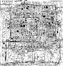
Map of Beijing in 1916 AD
Schematic Map of the the City of Beijing in 1916 AD, shortly after the 1911 Xinhai Revolution. Beijing was modernizing and China was experiencing the industrial Revolution.
Among the most noteworthy features of this Map are the QianMen Railway Station, at the Time the Main Railroad Station of Beijing.
Revolution and it's Inspiration to the Peoples of the Nation were installed in various stages on and along the Square.
Find DrBen and ChinaReport on Facebook with the latest from www.drben.net.