This page was last updated on: June 6, 2017
Hotel Beijing - First International Hotel in Beijing (constructed 1900 AD)
Elephant Stables
This Map clearly show the lay-out of Beiping - The Northern Capital (as Beijing was called at the Time), in 1916 AD, five years after the End of the Qing-Dynasty and the 1911 AD Xinghai Revolution. De-throned Emperor Pu Yi still inhabited The Imperial Palace, outside Beijing was modernizing and China was experiencing the industrial Revolution.

Among the most noteworthy features of this Map are: 1) The QianMen Railway Station, at the Time the First and Main Railroad Station of Beijing.
2) The small railway station outside and West of XizhiMen Gate, built in 1905 AD and diverting the Central Water supply of Beijing underground. Today Xizhimen Station is Beijing north Station - one of the Main Stations for Travel into Beijing's 6 Outer Suburban Districts and beyond.
3) The Imperial City and the much smaller TiananMen Square of 1916 AD. This Map is one of the Few maps that shows the Pre'-Revolutionary Lay-out of Tian'AnMen Square inlcuding the demolished ZhonghuaMen (now Mao Zedong Mausoleum). Further on this Map the First University of Beijing due East of Jingshan, the new University Campus north-west of Deshengmen, the Location of "The Legations" of Colonial Nations plus Todays remaining remnants and finally the location of the Beijing Hotel, first International Hotel built in the City in 1900 AD.

Clearly visable on this Map from the year 1916 are the Feng Shui-important Central City Axis with from South to North : YongDingMen , QianMen , TiananMen, WuMen, The Dragon Throne (inside TaiHeDian), Coal Hill and Drum- and Bell-Towers. All other former Gates are depicted and a  number of ancient landmarks & temples marked. Click sections of map to highlight individual city districts of XiCheng, DongCheng, Chongwen, Xuanwu with The Imperial Palace (Forbidden) City in the Center and the (then) Villages of Fengtai and Chaoyang in the West and East.
XiCheng and DongCheng were part of the Inner City, the Southern Districts were considered outside the Imperial Capital City proper, as they lay south of Qian Men, the Front Gate. Both Chongwen and Xuanwu were brought inside the protection of a City Wall and Moat, during the early Qing Dynasty Years.
Introduction to Map Beijing (Beiping) in 1916 AD - Beijing 1916 AD City Plan
Designates Central Axis of Imperial City Plan.
BeiHai Park's - Jade Island
Lama Temple - YongHe Gong
South Gate - Temple of Heaven & Park
QianHai
QianMen = Front Gate Inner City
Tian An Men
Drum Tower and Bell Tower
Go to www.drben.net webring
Jing Shan Imperial Garden (now a Public Park)
Altar of the Earth
Chongwen Men (Now Demolished)
Temple of Confucius
Imperial Academy & Hall of Classics
Dong Bian Men (DongNan Jiao Lou) Now Red Gate)
Altar of Agriculture (Remains)
Wu Men - 5 Phoenix Tower
Nan Hsi Men
Yun Ting Men (Now Yongding Men - Restored 2004 AD)
Chiang Tso Men
Sha KÓu Men - Sha Bridge Gate -Guan' Qu Men
He Ping Men (Now Demolished)
Shun Chi Men (XuanwuMen - Demolished)
Hsi Pien Men (Demolished)
P'Ing Tse Men (excavated remains)
Altar of the Moon
Altar of the Sun
Rice Paddies
Palace of Prince Ch'Un
Designates Imperial Family Mansion.
Yin Tai Palace (Prison Emperor Guanxu)
Hsi Chi Men (Xi Zhi Men)
De Sheng Men (Now a RingRoad Overpass + Road to Changping and Badaling)
An Ding Men (Preserved)
Tung Chi Men (Today Dong Zhi Men)
Chi Hua Men (Today Chao Yang Men)
Observatory on City Wall Platform
Hsi Tan Chi ChÁng - Market
Pei Ta
Hsi Tan Chi ChÁng - Market
Chinese Imperial & Government Structures.
Main Menu Page to all Parts of the Forbidden City
Northern Mansion (Pei Fu) - Palace of Prince Chun
Department Home Affairs 1st Republic of China
Northern Mansion - Palace of Prince Chuang
Former Peking University (1903 AD)
Imperial Gardens , later Zoo
ChinaReport.com at
To Main Menu of All Websites at DrBen.Net
Guang 'An Men (Demolished)
HanLin Academy 1860-1900 AD (Zhengyi Road - North Section)
Carriage Park of the Imperial City & Palace
Xu Wan Fu = Prince Xu TÚng Residencial Palace Mansion
Gong Wan Fu = Prince Gong Residential Palace Mansion
Fu Wan Fu = Prince Fu Residential Palace Mansion
?? Wan Fu = Prince ?? Residential Palace Mansion
Rice Paddies
TianNing Temple Pagoda - Temple of Heavenly Peace
Fayuan Si - Temple o/t Source o/t Law
NanTang - South Cathedral
QianMen Railway Station
ParliaMen Building 1st Republic of China
Xuanwu
Xicheng
Dongcheng
Chongwen
ChaoYang
Fengtai
Haidian
DonghuaMen - East (Flowery) Gate
ShenwuMen - Gate of Divine (Military) Might - North Gate
To Beijing Historic Maps - Index
Go to Next Page !
St. Savior- North Cathedral - Xishiku Cathedral
Chang'An Av.
Dashilar
QianMen
Hutong
TianQiao
Liu Lichang
Flower-Market Street
Haushi Si - West Flower Market Street Mosque
St. Joseph - DongTang - East Cathedral
HongQiao
BaiYunGuan - White Cloud Taoist temple
Bao Guo Temple
Nui Jie' Si - Ox Street Mosque
Dong Si - Eastern Mosque - Largest & Main Mosque in Beijing
Find DrBen and ChinaReport on Facebook with the latest from www.drben.net.
DrBen Nijhoff | Maak je eigen badge
Wen Tianxiang Temple
Zhi Hua Temple
Faxing Temple
Click Map Image to go to Full Version !!
Map of The City of Beijing and Wider Region in 1912 AD
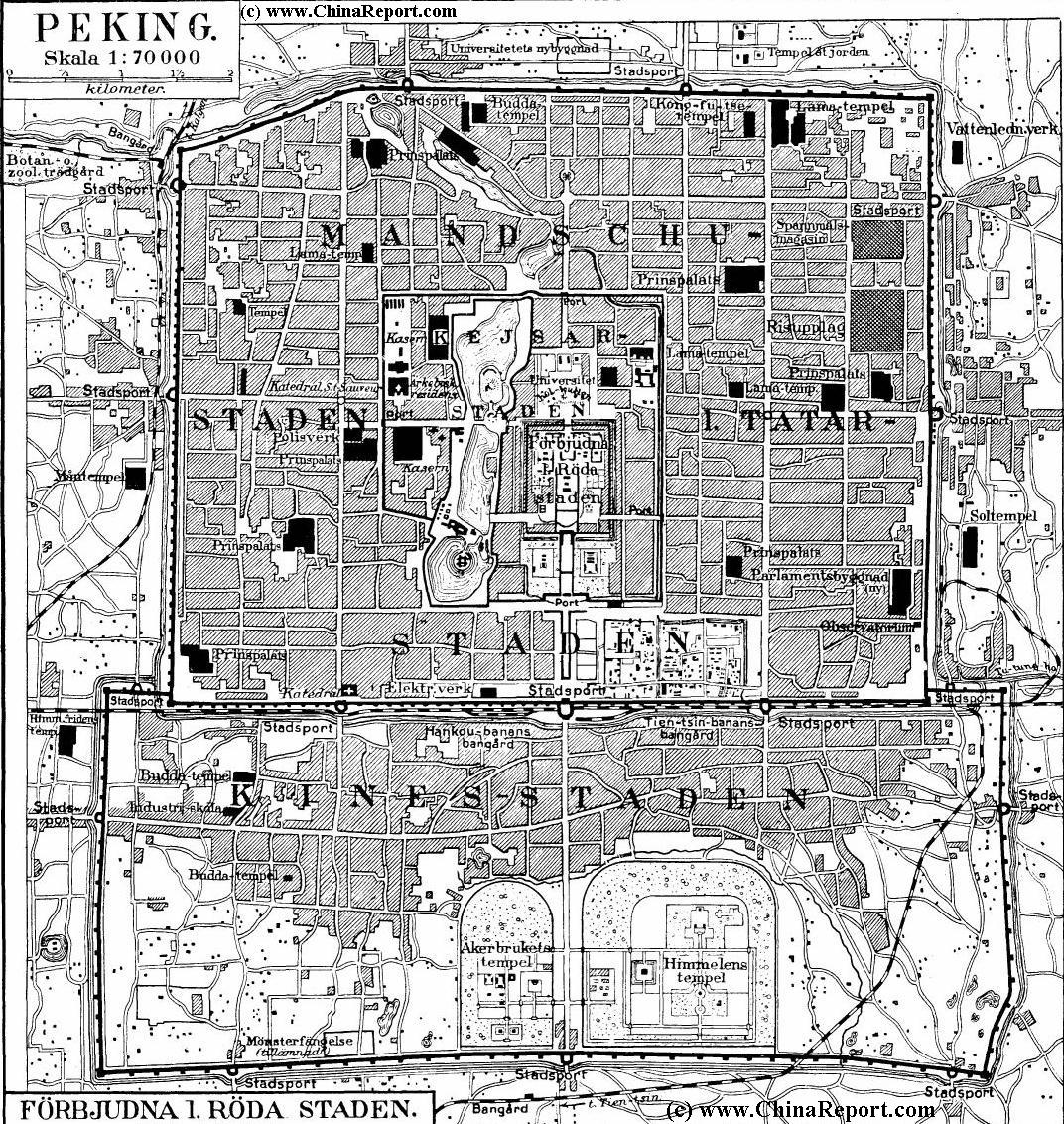
A Shematic Map of Beiping (Beijing) and immediate vicinity in the Year 1912 AD, using the Old (and oudated) naming sytem.
Map depicts major and minor roads, villages and Towns, Walled City of Beijing, Various Palaces of the Imperial Family, Temples, Mosques and Churches, The new railroad stations and lines such as Qianmen Station and Xizhimen Station both oustide the City Walls of Beijing, The Legations, buildings used by The Government of the First Republic of China, all city gates, outlying villages and roads, rivers in the region and more.
Map of Beijing and Wider Region in 1875 AD
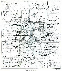
Shematic Map of Beiping (Beijing) and wider City Province in the Year 1875 AD using the Old (and outdated) naming system. Map depicts major and minor roads, villages and Towns, Walled City of Beijing, Old and
Click Map Image to go to FULL Version !!
New Summer Palaces, and many additional monuments.  There were no railroads in the area until 1899AD/1900
Beijing Landmarks
Beijing Introduction
Beijing Online Sources
Beijing
Beijing Home
Beijing Hotels
Beijing Maps - Index
Beijing Public Transport
City Province Transport
Beijing by District(s)
Chongwen
ChaoYang
Dongcheng
Fengtai
Haidian
XiCheng
Xuanwu
6 Outer Suburbs
TiananMen Square
Alphabetical Order
By Function(s)
Forbidden City
Hebei Province
Hebei Province Home
China Offline Sources
AsiaReport.com Home
China Report Home
China Online Sources
China Online Store
China Maps
China
China Photo Galleries
China Report Club
4 Rural Districts
Shijingshan
Maps of Chaoyang
Maps of Chongwen
Maps of Dongcheng
Maps of Fengtai
Maps of Xicheng
Maps of Xuanwu
Maps of Haidian
Maps of Shijingshan
Beijing Great Wall Maps
Beijing North China Maps
Historic Maps of Beijing
BJ Public Transport Maps
Altar of Agriculture (Xiannongtan)
Fasting Palace at Temple of Heaven & Park
Round Altar (Circular Altar) at Temple of Heaven & Park
Imperial Vault of Heaven Enclosure at Temple of Heaven & Park
Gate of Prayers for Good Harvests
Musical Administration at Temple of Heaven & Park